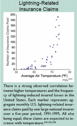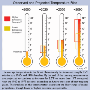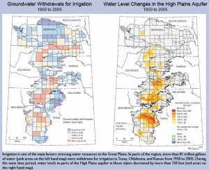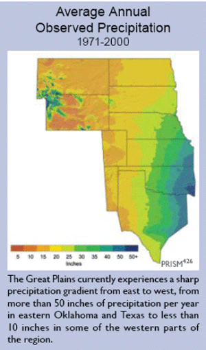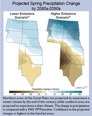
Key Messages:
• Ecosystem processes, such as those that control growth and decomposition, have been affected by climate change.
• Large-scale shifts have occurred in the ranges of species and the timing of the seasons and animal migration, and are very likely to continue.
• Fires, insect pests, disease pathogens, and invasive weed species have increased, and these trends are likely to continue.
• Deserts and drylands are likely to become hotter and drier, feeding a self-reinforcing cycle of invasive plants, fire, and erosion.
• Coastal and near-shore ecosystems are already under multiple stresses. Climate change and ocean acidification will exacerbate these stresses.
• Arctic sea ice ecosystems are already being adversely affected by the loss of summer sea ice and further changes are expected.
• The habitats of some mountain species and coldwater fish, such as salmon and trout, are very likely to contract in response to warming.
• Some of the benefits ecosystems provide to society will be threatened by climate change, while others will be enhanced.
The natural functioning of the environment provides both goods – such as food and other products that are bought and sold – and services, which our society depends upon. For example, ecosystems store large amounts of carbon in plants and soils; they regulate water flow and water quality; and they stabilize local climates. These services are not assigned a financial value, but society nonetheless depends on them. Ecosystem processes are the underpinning of these services: photosynthesis, the process by which plants capture carbon dioxide from the atmosphere and create new growth; the plant and soil processes that recycle nutrients from decomposing matter and maintain soil fertility; and the processes by which plants draw water from soils and return water to the atmosphere. These ecosystem processes are affected by climate and by the concentration of carbon dioxide in the atmosphere.70
The diversity of living things (biodiversity) in ecosystems is itself an important resource that maintains the ability of these systems to provide the services upon which society depends. Many factors affect biodiversity including: climatic conditions; the influences of competitors, predators, parasites, and diseases; disturbances such as fire; and other physical factors. Human-induced climate change, in conjunction with other stresses, is exerting major influences on natural environments and biodiversity, and these influences are generally expected to grow with increased warming.70
Ecosystem processes, such as those that control growth and decomposition, have been affected by climate change.
Climate has a strong influence on the processes that control growth and development in ecosystems. Temperature increases generally speed up plant growth, rates of decomposition, and how rapidly the cycling of nutrients occurs, though other factors, such as whether sufficient water is available, also influence these rates. The growing season is lengthening as higher temperatures occur earlier in the spring. Forest growth has risen over the past several decades as a consequence of a number of factors – young forests reaching maturity, an increased concentration of carbon dioxide in the atmosphere, a longer growing season, and increased deposition of nitrogen from the atmosphere. Based on the current understanding of these processes, the individual effects are difficult to disentangle.243
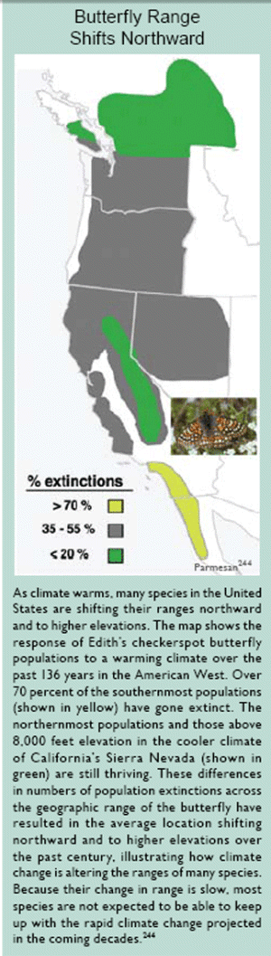
Butterfly Range Shifts Northward
As climate warms, many species in the United States are shifting their ranges northward and to higher elevations. The map shows the response of Edith’s checkerspot butterfly populations to a warming climate over the past 136 years in the American West. Over 70 percent of the southernmost populations (shown in yellow) have gone extinct. The northernmost populations and those above 8,000 feet elevation in the cooler climate of California’s Sierra Nevada (shown in green) are still thriving. These differences in numbers of population extinctions across the geographic range of the butterfly have resulted in the average location shifting northward and to higher elevations over the past century, illustrating how climate change is altering the ranges of many species. Because their change in range is slow, most species are not expected to be able to keep up with the rapid climate change projected in the coming decades.244
A higher atmospheric carbon dioxide concentration causes trees and other plants to capture more carbon from the atmosphere, but experiments show that trees put much of this extra carbon into producing fine roots and twigs, rather than new wood. The effect of carbon dioxide in increasing growth thus seems to be relatively modest, and generally is seen most strongly in young forests on fertile soils where there is also sufficient water to sustain this growth. In the future, as atmospheric carbon dioxide continues to rise, and as climate continues to change, forest growth in some regions is projected to increase, especially in relatively young forests on fertile soils.243
Forest productivity is thus projected to increase in much of the East, while it is projected to decrease in much of the West where water is scarce and projected to become more so. Wherever droughts increase, forest productivity will decrease and tree death will increase. In addition to occurring in much of the West, these conditions are projected to occur in parts of Alaska and in the eastern part of the Southeast.243
Large-scale shifts have occurred in the ranges of species and the timing of the seasons and animal migration, and are very likely to continue.
Climate change is already having impacts on animal and plant species throughout the United States. Some of the most obvious changes are related to the timing of the seasons: when plants bud in spring, when birds and other animals migrate, and so on. In the United States, spring now arrives an average of 10 days to two weeks earlier than it did 20 years ago. The growing season is lengthening over much of the continental United States. Many migratory bird species are arriving earlier. For example, a study of northeastern birds that migrate long distances found that birds wintering in the southern United States now arrive back in the Northeast an average of 13 days earlier than they did during the first half of the last century. Birds wintering in South America arrive back in the Northeast an average of four days earlier.70
Another major change is in the geographic distribution of species. The ranges of many species in the United States have shifted northward and upward in elevation. For example, the ranges of many butterfly species have expanded northward, contracted at the southern edge, and shifted to higher elevations as warming has continued. A study of Edith’s checkerspot butterfly showed that 40 percent of the populations below 2,400 feet have gone extinct, despite the availability of otherwise suitable habitat and food supply. The checkerspot’s most southern populations also have gone extinct, while new populations have been established north of the previous northern boundary for the species.70
For butterflies, birds, and other species, one of the concerns with such changes in geographic range and timing of migration is the potential for mismatches between species and the resources they need to survive. The rapidly changing landscape, such as new highways and expanding urban areas, can create barriers that limit habitat and increase species loss. Failure of synchronicity between butterflies and the resources they depend upon has led to local population extinctions of the checkerspot butterfly during extreme drought and low-snowpack years in California.70
Tree species shifts
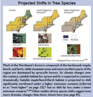
Forest tree species also are expected to shift their ranges northward and upslope in response to climate change, although specific quantitative predictions are very difficult to make because of the complexity of human land use and many other factors. This would result in major changes in the character of U.S. forests and the types of forests that will be most prevalent in different regions. In the United States, some common forests types are projected to expand, such as oak-hickory; others are projected to contract, such as maple-beech-birch. Still others, such as spruce-fir, are likely to disappear from the United States altogether.243
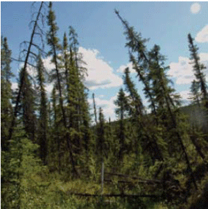
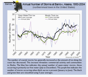
In Alaska, vegetation changes are already underway due to warming. Tree line is shifting northward into tundra, encroaching on the habitat for many migratory birds and land animals such as caribou that depend on the open tundra landscape.245
Marine species shifts and effects on fisheries
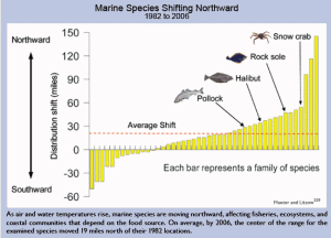
The distribution of marine fish and plankton are predominantly determined by climate, so it is not surprising that marine species in U.S. waters are moving northward and that the timing of plankton blooms is shifting. Extensive shifts in the ranges and distributions of both warmwater and coldwater species of fish have been documented.70 For example, in the waters around Alaska, climate change already is causing significant alterations in marine ecosystems with important implications for fisheries and the people who depend on them (see Alaska region).
In the Pacific, climate change is expected to cause an eastward shift in the location of tuna stocks.246 It is clear that such shifts are related to climate, including natural modes of climate variability such as the cycles of El Niño and La Niña. However, it is unclear how these modes of ocean variability will change as global climate continues to change, and therefore it is very difficult to predict quantitatively how marine fish and plankton species’ distributions might shift as a function of climate change.70
Breaking up of existing ecosystems
As warming drives changes in timing and geographic ranges for various species, it is important to note that entire communities of species do not shift intact. Rather, the range and timing of each species shifts in response to its sensitivity to climate change, its mobility, its lifespan, and the availability of the resources it needs (such as soil, moisture, food, and shelter). The speed with which species can shift their ranges is influenced by factors including their size, lifespan, and seed dispersal techniques in plants. In addition, migratory pathways must be available, such as northward flowing rivers which serve as conduits for fish. Some migratory pathways may be blocked by development and habitat fragmentation. All of these variations result in the breakup of existing ecosystems and formation of new ones, with unknown consequences.220
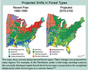
Projected Shifts in Forest Types
The maps show current and projected forest types. Major changes are projected for many regions. For example, in the Northeast, under a mid-range warming scenario, the currently dominant maple-beech-birch forest type is projected to be completely displaced by other forest types in a warmer future.243
Extinctions and climate change
Interactions among impacts of climate change and other stressors can increase the risk of species extinction. Extinction rates of plants and animals have already risen considerably, with the vast majority of these extinctions attributed to loss of habitat or over-exploitation.247 Climate change has been identified as a serious risk factor for the future, however, since it is one of the environmental stresses on species and ecosystems that is continuing to increase.247 The Intergovernmental Panel on Climate Change has estimated that if a warming of 3.5 to 5.5°F occurs, 20 to 30 percent of species that have been studied would be in climate zones that are far outside of their current ranges, and would therefore likely be at risk of extinction.248 One reason this percentage is so high is that climate change would be superimposed on other stresses including habitat loss and continued overharvesting of some species, resulting in considerable stress on populations and species.
Fires, insect pests, disease pathogens, and invasive weed species have increased, and these trends are likely to continue.
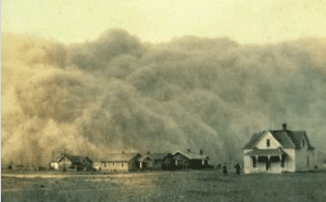
Forest fires
In the western United States, both the frequency of large wildfires and the length of the fire season have increased substantially in recent decades, due primarily to earlier spring snowmelt and higher spring and summer temperatures.294 These changes in climate have reduced the availability of moisture, drying out the vegetation that provides the fuel for fires. Alaska also has experienced large increases in fire, with the area burned more than doubling in recent decades. As in the western United States, higher air temperature is a key factor. In Alaska, for example, June air temperatures alone explained approximately 38 percent of the increase in the area burned annually from 1950 to 2003.243
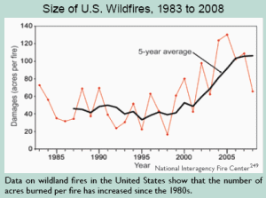
Size of U.S. Wildfires, 1983 to 2008
Data on wildland fires in the United States show that the number of acres burned per fire has increased since the 1980s.
Insect pests
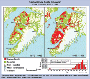
Insect pests are economically important stresses on forest ecosystems in the United States. Coupled with pathogens, they cost $1.5 billion in damage per year. Forest insect pests are sensitive to climatic variations in many stages of their lives. Changes in climate have contributed significantly to several major insect pest outbreaks in the United States and Canada over the past several decades. The mountain pine beetle has infested lodgepole pine in British Columbia. Over 33 million acres of forest have been affected, by far the largest such outbreak in recorded history. Another 1.5 million acres have been infested by pine beetle in Colorado. Spruce beetle has affected more than 2.5 million acres in Alaska (see Alaska region) and western Canada. The combination of drought and high temperatures also has led to serious insect infestations and death of piñon pine in the Southwest, and to various insect pest attacks throughout the forests of the eastern United States.243
Rising temperatures increase insect outbreaks in a number of ways. First, winter temperatures above a certain threshold allow more insects to survive the cold season that normally limits their numbers. Second, the longer warm season allows them to develop faster, sometimes completing two life cycles instead of one in a single growing season. Third, warmer conditions help expand their ranges northward. And fourth, drought stress reduces trees’ ability to resist insect attack (for example, by pushing back against boring insects with the pressure of their sap). Spruce beetle, pine beetle, spruce budworm, and woolly adelgid (which attacks eastern hemlocks) are just some of the insects that are proliferating in the United States, devastating many forests. These outbreaks are projected to increase with ongoing warming. Trees killed by insects also provide more dry fuel for wildfires.70,243,250
Disease pathogens and their carriers
One consequence of a longer, warmer growing season and less extreme cold in winter is that opportunities are created for many insect pests and disease pathogens to flourish. Accumulating evidence links the spread of disease pathogens to a warming climate. For example, a recent study showed that widespread amphibian extinctions in the mountains of Costa Rica are linked to changes in climatic conditions which are thought to have enabled the proliferation of an amphibian disease.70,251
Diseases that affect wildlife and the living things that carry these diseases have been expanding their geographic ranges as climate heats up. Depending on their specific adaptations to current climate, many parasites, and the insects, spiders, and scorpions that carry and transmit diseases, die or fail to develop below threshold temperatures. Therefore, as temperatures rise, more of these disease-carrying creatures survive. For some species, rates of reproduction, population growth, and biting, tend to increase with increasing temperatures, up to a limit. Some parasites’ development rates and infectivity periods also increase with temperature.70 An analysis of diseases among marine species found that diseases were increasing for mammals, corals, turtles, and mollusks, while no trends were detected for sharks, rays, crabs, and shrimp.70
Invasive plants
Problems involving invasive plant species arise from a mix of human-induced changes, including disturbance of the land surface (such as through over grazing or clearing natural vegetation for development), deliberate or accidental transport of non-native species, the increase in available nitrogen through over-fertilization of crops, and the rising carbon dioxide concentration and the resulting climate change.243 Human-induced climate change is not generally the initiating factor, nor the most important one, but it is becoming a more important part of the mix.
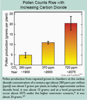
The increasing carbon dioxide concentration stimulates the growth of most plant species, and some invasive plants respond with greater growth rates than native plants. Beyond this, invasive plants appear to better tolerate a wider range of environmental conditions and may be more successful in a warming world because they can migrate and establish themselves in new sites more rapidly than native plants.70 They are also not usually dependent on external pollinators or seed dispersers to reproduce. For all of these reasons, invasive plant species present a growing problem that is extremely difficult to control once unleashed.70
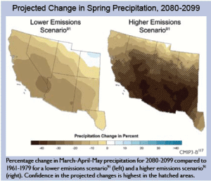
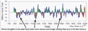
Deserts and drylands are likely to become hotter and drier, feeding a self-reinforcing cycle of invasive plants, fire, and erosion.
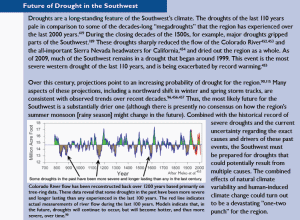
The arid Southwest is projected to become even drier in this century. There is emerging evidence that this is already underway.34 Deserts in the United States are also projected to expand to the north, east, and upward in elevation in response to projected warming and associated changes in climate.
Increased drying in the region contributes to a variety of changes that exacerbate a cycle of desertification. Increased drought conditions cause perennial plants to die due to water stress and increased susceptibility to plant diseases. At the same time, non-native grasses have invaded the region. As these grasses increase in abundance, they provide more fuel for fires, causing fire frequency to increase in a self- reinforcing cycle that leads to further losses of vegetation. When it does rain, the rain tends to come in heavy downpours, and since there is less vegetation to protect the soil, water erosion increases. Higher air temperatures and decreased soil moisture reduce soil stability, further exacerbating erosion. And with a growing population needing water for urban uses, hydroelectric generation, and agriculture, there is increasing pressure on mountain water sources that would otherwise flow to desert river areas.70,149
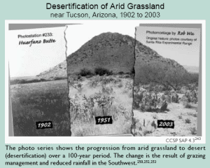
Desertification of Arid Grassland near Tucson, Arizona, 1902 to 2003
The photo series shows the progression from arid grassland to desert (desertification) over a 100-year period. The change is the result of grazing management and reduced rainfall in the Southwest.250,252,253
The response of arid lands to climate change also depends on how other factors interact with climate at local scales. Large-scale, unregulated livestock grazing in the Southwest during the late 1800s and early 1900s is widely regarded as having contributed to widespread desertification. Grazing peaked around 1920 on public lands in the West. By the 1970s, grazing had been reduced by about 70 percent, but the arid lands have been very slow to recover from its impacts. Warmer and drier climate conditions are expected to slow recovery even more. In addition, the land resource in the Southwest is currently managed more for providing water for people than for protecting the productivity of the landscape. As a result, the land resource is likely to be further degraded and its recovery hampered.243
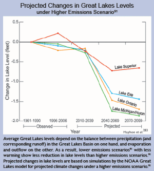
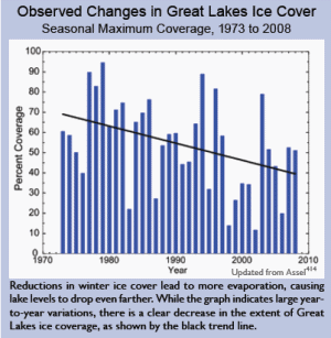
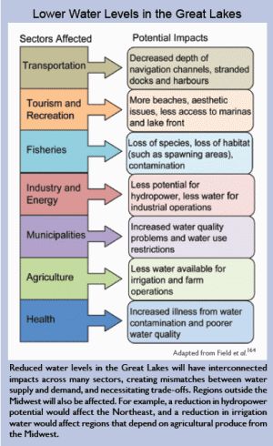
Coastal and near-shore ecosystems are already under multiple stresses. Climate change and ocean acidification will exacerbate these stresses.
Coastal and near-shore marine ecosystems are vulnerable to a host of climate change-related effects including increasing air and water temperatures, ocean acidification, changes in runoff from the land, sea-level rise, and altered currents. Some of these changes have already led to coral bleaching, shifts in species ranges, increased storm intensity in some regions, dramatic reductions in sea ice extent and thickness along the Alaskan coast,137 and other significant changes to the nation’s coastlines and marine ecosystems.70
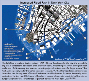
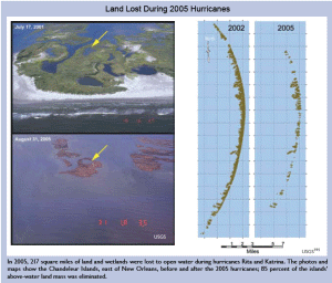
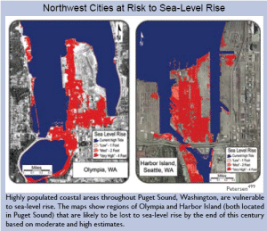
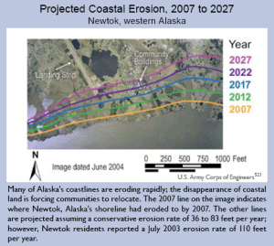
The interface between land and sea is important, as many species, including many endangered species, depend on it at some point in their life cycle. In addition, coastal areas buffer inland areas from the effects of wave action and storms.247 Coastal wetlands, intertidal areas, and other near-shore ecosystems are subject to a variety of environmental stresses.254,255 Sea-level rise, increased coastal storm intensity, and rising temperatures contribute to increased vulnerability of coastal wetland ecosystems. It has been estimated that 3 feet of sea-level rise (within the range of projections for this century) would inundate about 65 percent of the coastal marshlands and swamps in the contiguous United States.256 The combination of sea-level rise, local land sinking, and related factors already have resulted in substantially higher relative sea-level rise along the Gulf of Mexico and the mid-Atlantic coast, more so than on the Pacific Coast.43,254 In Louisiana alone, over one-third of the coastal plain that existed a century ago has since been lost,254 which is mostly due to local land sinking.70 Barrier islands are also losing land at an increasing rate257 (see Southeast region), and they are particularly important in protecting the coastline in some regions vulnerable to sea-level rise and storm surge.
Coral reefs
Coral reefs are very diverse ecosystems that support many other species by providing food and habitat. In addition to their ecological value, coral reefs provide billions of dollars in services including tourism, fish breeding habitat, and protection of coastlines. Corals face a host of challenges associated with human activities such as poorly regulated tourism, destructive fishing, and pollution, in addition to climate change-related stresses.70
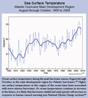
Corals are marine animals that host symbiotic algae which help nourish the animals and give the corals their color. When corals are stressed by increases in water temperatures or ultraviolet light, they lose their algae and turn white, a process called coral bleaching. If the stress persists, the corals die. Intensities and frequencies of bleaching events, clearly driven by warming in surface water, have increased substantially over the past 30 years, leading to the death or severe damage of about one-third of the world’s corals.70
The United States has extensive coral reef ecosystems in the Caribbean, Atlantic, and Pacific oceans. In 2005, the Caribbean basin experienced unprecedented water temperatures that resulted in dramatic coral bleaching with some sites in the U.S. Virgin Islands seeing 90 percent of the coral bleached. Some corals began to recover when water temperatures decreased, but later that year disease appeared, striking the previously bleached and weakened coral. To date, 50 percent of the corals in Virgin Islands National Park have died from the bleaching and disease events. In the Florida Keys, summer bleaching in 2005 was also followed by disease in September.70
But rising temperature is not the only stress coral reefs face. As the carbon dioxide concentration in the air increases, more carbon dioxide is absorbed into the world’s oceans, leading to their acidification. This makes less calcium carbonate available for corals and other sea life to build their skeletons and shells.258 If carbon dioxide concentrations continue to rise and the resulting acidification proceeds, eventually, corals and other ocean life that rely on calcium carbonate will not be able to build these skeletons and shells at all. The implications of such extreme changes in ocean ecosystems are not clear, but there is now evidence that in some ocean areas, such as along the Northwest coast, acidification is already occurring70,259 (see Coasts region for more discussion of ocean acidification).
Arctic sea ice ecosystems are already being adversely affected by the loss of summer sea ice and further changes are expected.
Perhaps most vulnerable of all to the impacts of warming are Arctic ecosystems that rely on sea ice, which is vanishing rapidly and is projected to disappear entirely in summertime within this century. Algae that bloom on the underside of the sea ice form the base of a food web linking microscopic animals and fish to seals, whales, polar bears, and people. As the sea ice disappears, so too do these algae. The ice also provides a vital platform for ice-dependent seals (such as the ringed seal) to give birth, nurse their pups, and rest. Polar bears use the ice as a platform from which to hunt their prey. The walrus rests on the ice near the continental shelf between its dives to eat clams and other shellfish. As the ice edge retreats away from the shelves to deeper areas, there will be no clams nearby.70,132,220
The Bering Sea, off the west coast of Alaska, produces our nation’s largest commercial fish harvests as well as providing food for many Native Alaskan peoples. Ultimately, the fish populations (and animals including seabirds, seals, walruses, and whales) depend on plankton blooms regulated by the extent and location of the ice edge in spring. As the sea ice continues to decline, the location, timing, and species composition of the blooms is changing. The spring melt of sea ice in the Bering Sea has long provided material that feeds the clams, shrimp, and other life forms on the ocean floor that, in turn, provide food for the walruses, gray whales, bearded seals, eider ducks, and many fish. The earlier ice melt resulting from warming, however, leads to later phytoplankton blooms that are largely consumed by microscopic animals near the sea surface, vastly decreasing the amount of food reaching the living things on the ocean floor. This will radically change the species composition of the fish and other creatures, with significant repercussions for both subsistence and commercial fishing.70
Ringed seals give birth in snow caves on the sea ice, which protect their pups from extreme cold and predators. Warming leads to earlier snow melt, which causes the snow caves to collapse before the pups are weaned. The small, exposed pups may die of hypothermia or be vulnerable to predation by arctic foxes, polar bears, gulls, and ravens. Gulls and ravens are arriving in the Arctic earlier as springs become warmer, increasing the birds’ opportunity to prey on the seal pups.70
Polar bears are the top predators of the sea ice ecosystem. Because they prey primarily on ice-associated seals, they are especially vulnerable to the disappearance of sea ice. The bears’ ability to catch seals depends on the presence of sea ice. In that habitat, polar bears take advantage of the fact that seals must surface to breathe in limited openings in the ice cover. In the open ocean, bears lack a hunting platform, seals are not restricted in where they can surface, and successful hunting is very rare. On shore, polar bears feed little, if at all.
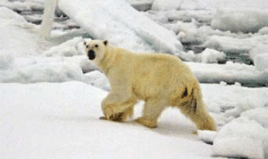
About two-thirds of the world’s polar bears are projected to be gone by the middle of this century. It is projected that there will be no wild polar bears in Alaska in 75 years.70
In addition, the rapid rate of warming in Alaska and the rest of the Arctic in recent decades is sharply reducing the snow cover in which polar bears build dens and the sea ice they use as foraging habitat. Female polar bears build snow dens in which they hibernate for four to five months each year and in which they give birth to their cubs. Born weighing only about 1 pound, the tiny cubs depend on the snow den for warmth.
About two-thirds of the world’s polar bears are projected to be gone by the middle of this century. It is projected that there will be no wild polar bears left in Alaska in 75 years.70
Continued warming will inevitably entail major changes in the sea ice ecosystem, to the point that its viability is in jeopardy. Some species will become extinct, while others might adapt to new habitats. The chances of species surviving the current changes may depend critically on the rate of change. The current rates of change in the sea ice ecosystem are very rapid relative to the life spans of animals including seals, walruses, and polar bears, and as such, are a major threat to their survival.70
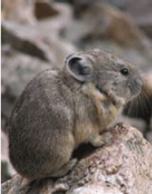
The pika, pictured above, is a small mammal whose habitat is limited to cold areas near the tops of mountains. As climate warms, little suitable habitat is left. Of 25 pika populations studied in the Great Basin between the Rocky Mountains and the Sierra Nevada, more than one-third have gone extinct in recent decades.261,262
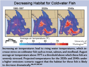
The habitats of some mountain species and coldwater fish, such as salmon and trout, are very likely to contract in response to warming.
Animal and plant species that live in the mountains are among those particularly sensitive to rapid climate change. They include animal species such as the grizzly bear, bighorn sheep, pika, mountain goat, and wolverine. Major changes have already been observed in the pika as previously reported populations have disappeared entirely as climate has warmed over recent decades.70 One reason mountain species are so vulnerable is that their suitable habitats are being compressed as climatic zones shift upward in elevation. Some species try to shift uphill with the changing climate, but may face constraints related to food, other species present, and so on. In addition, as species move up the mountains, those near the top simply run out of habitat.70
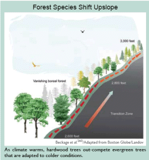
Forest Species Shift Upslope
As climate warms, hardwood trees out-compete evergreen trees that are adapted to colder conditions.
Fewer wildflowers are projected to grace the slopes of the Rocky Mountains as global warming causes earlier spring snowmelt. Larkspur, aspen fleabane, and aspen sunflower grow at an altitude of about 9,500 feet where the winter snows are deep. Once the snow melts, the flowers form buds and prepare to bloom. But warmer springs mean that the snow melts earlier, leaving the buds exposed to frost. (The percentage of buds that were frosted has doubled over the past decade.) Frost does not kill the plants, but it does make them unable to seed and reproduce, meaning there will be no next generation. Insects and other animal species depend on the flowers for food, and other species depend on those species, so the loss is likely to propagate through the food chain.236
Shifts in tree species on mountains in New England, where temperatures have risen 2 to 4°F in the last 40 years, offer another example. Some mountain tree species have shifted uphill by 350 feet in the last 40 years. Tree communities were relatively unchanged at low and high elevations, but in the transition zone in between (at about 2,600 feet elevation) the changes have been dramatic. Cold-loving tree species declined from 43 to 18 percent, while warmer-loving trees increased from 57 to 82 percent. Overall, the transition zone has shifted about 350 feet uphill in just a few decades, a surprisingly rapid rate since these are trees that live for hundreds of years. One possibility is that as trees were damaged or killed by air pollution, it left an opportunity for the warming-induced transition to occur more quickly. These results indicate that the composition of high elevation forests is changing rapidly.260
Coldwater fish
Salmon and other coldwater fish species in the United States are at particular risk from warming. Salmon are under threat from a variety of human activities, but global warming is a growing source of stress. Rising temperatures affect salmon in several important ways. As precipitation increasingly falls as rain rather than snow, it feeds floods that wash away salmon eggs incubating in the streambed. Warmer water leads eggs to hatch earlier in the year, so the young are smaller and more vulnerable to predators. Warmer conditions increase the fish’s metabolism, taking energy away from growth and forcing the fish to find more food, but earlier hatching of eggs could put them out of sync with the insects they eat. Earlier melting of snow leaves rivers and streams warmer and shallower in summer and fall. Diseases and parasites tend to flourish in warmer water. Studies suggest that up to 40 percent of Northwest salmon populations may be lost by 2050.263
Large declines in trout populations are also projected to occur around the United States. Over half of the wild trout populations are likely to disappear from the southern Appalachian Mountains because of the effects of rising stream temperatures. Losses of western trout populations may exceed 60 percent in certain regions. About 90 percent of bull trout, which live in western rivers in some of the country’s most wild places, are projected to be lost due to warming. Pennsylvania is predicted to lose 50 percent of its trout habitat in the coming decades. Projected losses of trout habitat for some warmer states, such as North Carolina and Virginia, are up to 90 percent.264
Some of the benefits ecosystems provide to society will be threatened by climate change, while others will be enhanced.
Human well-being depends on the Earth’s ecosystems and the services that they provide to sustain and fulfill human life.265 These services are important to human well-being because they contribute to basic material needs, physical and psychological health, security, and economic activity. A recent assessment reported that of 24 vital ecosystem services, 15 were being degraded by human activity.247 Climate change is one of several human-induced stresses that threaten to intensify and extend these adverse impacts to biodiversity, ecosystems, and the services they provide. Two of many possible examples follow.
Forests and carbon storage
Forests provide many services important to the well-being of Americans: air and water quality maintenance, water flow regulation, and watershed protection; wildlife habitat and biodiversity conservation; recreational opportunities and aesthetic and spiritual fulfillment; raw materials for wood and paper products; and climate regulation and carbon storage. A changing climate will alter forests and the services they provide. Most of these changes are likely to be detrimental.
In the United States, forest growth and long-lived forest products currently offset about 20 percent of U.S. fossil fuel carbon emissions.140,257 This carbon “sink” is an enormous service provided by forests and its persistence or growth will be important to limiting the atmospheric carbon dioxide concentration. The scale of the challenge of increasing this sink is very large. To offset an additional 10 percent of U.S. emissions through tree planting would require converting one-third of current croplands to forests.243
Recreational opportunities
Tourism is one of the largest economic sectors in the world, and it is also one of the fastest growing;266 the jobs created by recreational tourism provide economic benefits not only to individuals but also to communities. Slightly more than 90 percent of the U.S. population participates in some form of outdoor recreation, representing nearly 270 million participants,267 and several billion days spent each year in a wide variety of outdoor recreation activities.
Since much recreation and tourism occurs outside, increased temperature and precipitation have a direct effect on the enjoyment of these activities, and on the desired number of visitor days and associated level of visitor spending as well as tourism employment. Weather conditions are an important factor influencing tourism visits. In addition, outdoor recreation and tourism often depends on the availability and quality of natural resources,268 such as beaches, forests, wetlands, snow, and wildlife, all of which will be affected by climate change.
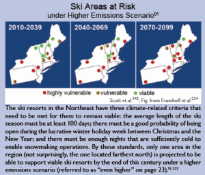
Thus, climate change can have direct effects on the natural resources that people enjoy. The length of the season for, and desirability of, several of the most popular activities – walking; visiting a beach, lakeshore, or river; sightseeing; swimming; and picnicking267 – are likely to be enhanced by small near-term increases in temperature. Other activities are likely to be harmed by even small increases in warming, such as snow- and ice-dependent activities including skiing, snowmobiling, and ice fishing.
The net economic effect of near-term climate change on recreational activities is likely to be positive. In the longer term, however, as climate change effects on ecosystems and seasonality become more pronounced, the net economic effect on tourism and recreation is not known with certainty.172
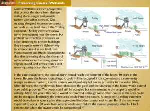
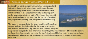
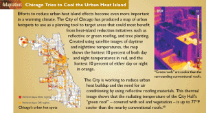
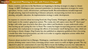
Adaptation: Preserving Coastal Wetlands
Coastal wetlands are rich ecosystems that protect the shore from damage during storm surges and provide society with other services. One strategy designed to preserve coastal wetlands as sea level rises is the “rolling easement.” Rolling easements allow some development near the shore, but prohibit construction of seawalls or other armoring to protect buildings; they recognize nature’s right-of-way to advance inland as sea level rises. Massachusetts and Rhode Island prohibit shoreline armoring along the shores of some estuaries so that ecosystems can migrate inland, and several states limit armoring along ocean shores.269,270
In the case shown here, the coastal marsh would reach the footprint of the house 40 years in the future. Because the house is on pilings, it could still be occupied if it is connected to a community sewage treatment system; a septic system would probably fail due to proximity to the water table. After 80 years, the marsh would have taken over the yard, and the footprint of the house would extend onto public property. The house could still be occupied but reinvestment in the property would be unlikely. After 100 years, this house would be removed, although some other houses in the area could still be occupied. Eventually, the entire area would return to nature. A home with a rolling easement would depreciate in value rather than appreciate like other coastal real estate. But if the loss were expected to occur 100 years from now, it would only reduce the current property value by 1 to 5 percent, for which the owner could be compensated.271
Modified from CCSP SAP 4.1271