Achaemenid conquest of the Indus Valley
by Wikipedia
Accessed: 6/22/24
Achaemenid conquest of the Indus Valley
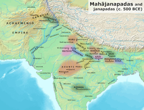
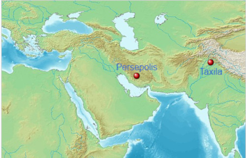
Map of ancient India, c. 500 BCE, with the Persian frontier delineated along the Indus River and the Jhelum River[1][2][3][4]
Date: c. 535/518 BCE – 323 BCE[1]
Location: Indus Valley
Result: Persian victory
Territorial changes: Annexation of the Indus Valley by the Persians
Belligerents
Achaemenid Empire; Gandhara; Kambojas
Commanders and leaders
Cyrus the Great; Darius the Great; Various
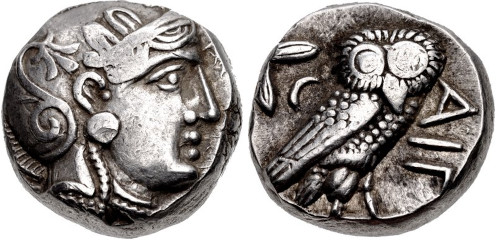
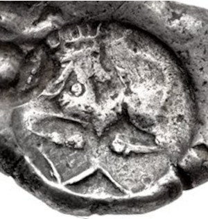
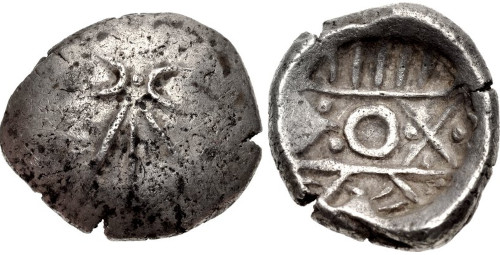
Achaemenid coin, an imitation of an Athenian coin type, of the sort found in the Kabul hoard.[5]
Around 535 BCE, the Persian king Cyrus the Great initiated a protracted campaign to absorb parts of India into his nascent Achaemenid Empire.[1] In this initial incursion, the Persian army annexed a large region to the west of the Indus River, consolidating the early eastern borders of their new realm. With a brief pause after Cyrus' death around 530 BCE, the campaign continued under Darius the Great, who began to re-conquer former provinces and further expand the Achaemenid Empire's political boundaries. Around 518 BCE, the Persian army pushed further into India to initiate a second period of conquest by annexing regions up to the Jhelum River in what is today known as Punjab.[6] At peak, the Persians managed to take control of most of modern-day Pakistan and incorporate it into their territory.
The first secure epigraphic evidence through the Behistun Inscription gives a date before or around 518 BCE. Persian penetration into the Indian subcontinent occurred in multiple stages, beginning from the northern parts of the Indus River and moving southward.[7] As mentioned in several Achaemenid-era inscriptions, the Indus Valley was formally incorporated into the Persian realm through provincial divisions: Gandāra, Hindush, and Sattagydia.
Persian rule over the Indus Valley decreased over successive rulers and formally ended with the Greek conquest of Persia, led by Alexander the Great. This brief period gave rise to independent Indian kings, such as Abisares, Porus, and Ambhi, as well as numerous gaṇasaṅghas, which would later confront the Macedonian army as it massed into the region for Alexander's Indian campaign.[1] The Achaemenid Empire set a precedence of governance through the use of satrapies,[8] which was further implemented by Alexander's Macedonian Empire, the Indo-Scythians, and the Kushan Empire.
Background and invasion
India appears to the east of the inhabited world according to Herodotus, 500 BCE.
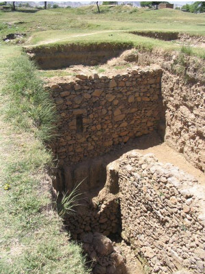
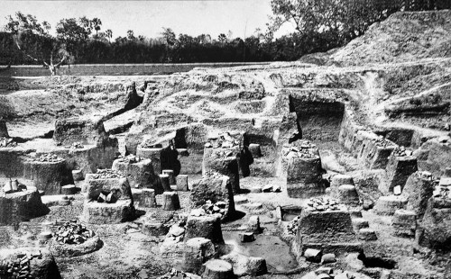
Ruins at Bhir Mound representing the city of Taxila during the Achaemenid period
For millennia, the northwestern part of India had maintained some level of trade relations with the Near East. Finally, the Achaemenid Empire underwent a considerable expansion, both east and west, during the reign of Cyrus the Great (c.600–530 BC), leading the dynasty to take a direct interest into the region of northwestern India.[1]
Cyrus the Great
The conquest is often thought to have started circa 535 BCE, during the time of Cyrus the Great (600-530 BCE).[9][10][1] Cyrus probably went as far as the banks of the Indus river and organized the conquered territories under the Satrapy of Gandara (Old Persian cuneiform: [x], Gadāra, also transliterated as Gandāra since the nasal "n" before consonants was omitted in the Old Persian script, and simplified as Gandara)[11] according to the Behistun Inscription.[12] The Province was also referred to as Paruparaesanna (Greek: Parapamisadae) in the Babylonian and Elamite versions of the Behistun inscription.[12] The geographical extent of this province was wider than the Indian Gandhara.[13] Various accounts, such as those of Xenophon or Ctesias, who wrote Indica, also suggest that Cyrus conquered parts of India.[14][1] Another Indian Province was conquered named Sattagydia ([x], Thatagus) in the Behistun inscription. It was probably contiguous to Gandhara, but its actual location is uncertain. Fleming locates it between Arachosia and the middle Indus.[15] Fleming also mentions Maka, in the area of Gedrosia, as one of the Indian satrapies.[16]
Darius I
A successor of Cyrus the Great, Darius I was back in 518 BCE. The date of 518 BCE is given by the Behistun inscription, and is also often the one given for the secure occupation of Gandhara in Punjab.[17] Darius I later conquered an additional province that he calls "Hidūš" in his inscriptions (Old Persian cuneiform: [x], H-i-du-u-s, also transliterated as Hindus since the nasal "n" before consonants was omitted in the Old Persian script, and simplified as Hindush), corresponding to the Indus Valley.[18][11][19] The Hamadan Gold and Silver Tablet inscription[20] of Darius I also refers to his conquests in India.[1]
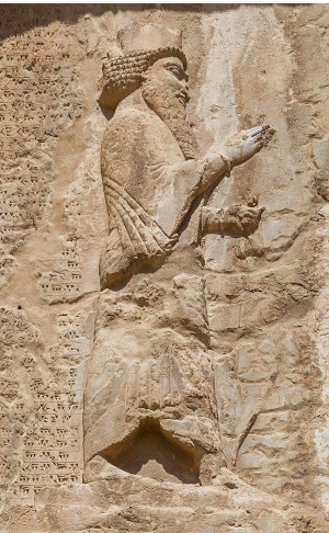
Darius I on his tomb.
The exact area of the Province of Hindush is uncertain. Some scholars have described it as the middle and lower Indus Valley and the approximate region of modern Sindh,[21] but there is no known evidence of Achaemenid presence in this region, and deposits of gold, which Herodotus says was produced in vast quantities by this Province, are also unknown in the Indus delta region.[22] Alternatively, Hindush may have been the region of Taxila and Western Punjab, where there are indications that a Persian satrapy may have existed.[22] There are few remains of Achaemenid presence in the east, but, according to Fleming, the archaeological site of Bhir Mound in Taxila remains the "most plausible candidate for the capital of Achaemenid India", based on the fact that numerous pottery styles similar to those of the Achaemenids in the East have been found there, and that "there are no other sites in the region with Bhir Mound's potential".[23]
According to Herodotus, Darius I sent the Greek explorer Scylax of Caryanda to sail down the Indus river, heading a team of spies, in order to explore the course of the Indus river. After a periplus of 30 months, Scylax is said to have returned to Egypt near the Red Sea, and the seas between the Near East and India were made use of by Darius.[24][25]
Also according to Herodotus, the territories of Gandhara, Sattagydia, Dadicae and Aparytae formed the 7th province of the Achaemenid Empire for tax-payment purposes, while Indus (called [x], "Indos" in Greek sources) formed the 20th tax region.
Achaemenid army
See also: Achaemenid army
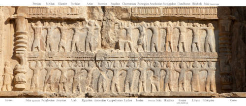
Greek Ionian (Yavanas), Scythian (Sakas) and Persian (Parasikas) soldiers of the Achaemenid army, as described on Achaemenid royal tombs from circa 500 to 338 BCE.
Throughout its existence, the Achaemenid were constantly engaging in wars. Either through conquering new territories or by quelling rebellions throughout the empire. To fulfil this need, the Achaemenid Empire had to maintain a professional standing army which levied and employed personnel from all of its satraps and territories.[26]
The Achaemenid army was not uniquely Persian. Rather it was composed of many different ethnicities that were part of the vast and diverse Achaemenid Empire. Herodotus gives a full list of the ethnicities of the Achaemenid army, in which are included Bactrians, Sakas (Scythians), Parthians, Sogdians,[27] Ionians (Greeks), Egyptians, Ethiopians, etc.[28][27] These ethnicities are likely to have been included in the Achaemenid army during the invasions of India.[27]
Inscriptions and accounts
Indian satrapies on the Statue of Darius I
[x] h-n-d-wꜣ-y Hindush ("India")[29]
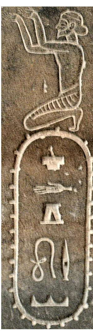
sꜣ-d-g-wꜣ-ḏꜣ Sattagydia;
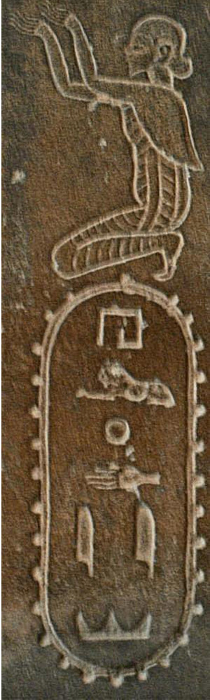
[i]h-rw-ḫ-d-y Gandara
These events were recorded in the imperial inscriptions of the Achaemenids (the Behistun inscription and the Naqsh-i-Rustam inscription, as well as the accounts of Herodotus (483–431 BCE). The Greek Scylax of Caryanda, who had been appointed by Darius I to explore the Indian Ocean from the mouth of the Indus to Suez left an account, the Periplous, of which fragments from secondary sources have survived. Hecataeus of Miletus (circa 500 BCE) also wrote about the "Indus Satrapies" of the Achaemenids.
Behistun inscription
The 'DB' Behistun inscription[30] of Darius I (circa 510 BCE) mentions Gandara ([x], Gadāra) and the adjacent territory of Sattagydia ([x], Thataguš) as part of the Achaemenid Empire:
King Darius says: These are the countries which are subject unto me, and by the grace of Ahuramazda I became king of them: Persia [Pârsa], Elam [Ûvja], Babylonia [Bâbiruš], Assyria [Athurâ], Arabia [Arabaya], Egypt [Mudrâya], the countries by the Sea, Lydia [Sparda], the Greeks [Yauna (Ionia)], Media [Mâda], Armenia [Armina], Cappadocia [Katpatuka], Parthia [Parthava], Drangiana [Zraka], Aria [Haraiva], Chorasmia [Uvârazmîy], Bactria [Bâxtriš], Sogdia [Suguda], Gandara [Gadāra], Scythia [Saka], Sattagydia [Thatagus], Arachosia [Harauvatiš] and Maka [Maka]; twenty-three lands in all.
— Behistun Inscription of Darius I.[31][32]
From the dating of the Behistun inscription, it is possible to infer that the Achaemenids first conquered the areas of Gandara and Sattagydia circa 518 BCE.
Statue of Darius inscriptions
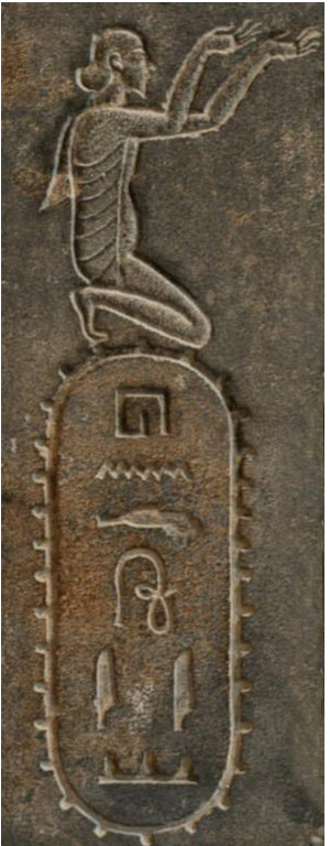
Hinduš is also mentioned as one of 24 subject countries of the Achaemenid Empire, illustrated with the drawing of a kneeling subject and a hieroglyphic cartridge reading [x] (h-n-d-w-y), on the Egyptian Statue of Darius I, now in the National Museum of Iran. Sattagydia also appears ([x], sꜣ-d-g-w-ḏ, Sattagydia), and probably Gandara ([x], h-rw-ḫ-d-y, although this could be Arachosia), with their own illustrations.[33][29]
Apadana Palace foundation tablets
Gold foundation plate of Darius I in the Apadana Palace in Persepolis with the word Hidauv, locative of "Hidus".[34]
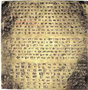
Four identical foundation tablets of gold and silver, found in two deposition boxes in the foundations of the Apadana Palace, also contained an inscription by Darius I in Old Persian cuneiform, which describes the extent of his Empire in broad geographical terms, from the Indus valley in the east to Lydia in the west, and from the Scythians beyond Sogdia in the north, to the African Kingdom of Kush in the south. This is known as the DPh inscription.[35][36] The deposition of these foundation tablets and the Apadana coin hoard found under them, is dated to circa 515 BCE.[35]
Darius the great king, king of kings, king of countries, son of Hystaspes, an Achaemenid. King Darius says: This is the kingdom which I hold, from the Sacae who are beyond Sogdia to Kush, and from Sind (Old Persian: [x], "Hidauv", locative of "Hiduš", i.e. "Indus valley") to Lydia (Old Persian: "Spardâ") - [this is] what Ahuramazda, the greatest of gods, bestowed upon me. May Ahuramazda protect me and my royal house!
— DPh inscription of Darius I in the foundations of the Apadana Palace[37]
Naqsh-e Rustam inscription
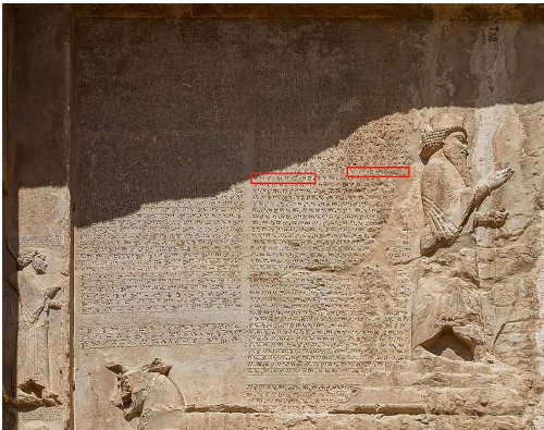
The Naqsh-e Rustam DNa inscription, on the tomb of Darius I, mentioning all three Indian territories: Sattagydia ([x], Thataguš), Gandara ([x], Gadāra) and India ([x], Hidūš) as part of the Achaemenid Empire.[38]
The DSe inscription[39] and DSm inscription[40] of Darius in Susa gives Thataguš (Sattagydia), Gadāra (Gandara) and Hiduš (Sind) among the nations that he rules.[39][29]
Hidūš ([x] in Old Persian cuneiform) also appears later as a Satrapy in the Naqsh-i-Rustam inscription at the end of the reign of Darius, who died in 486 BCE.[29] The DNa inscription[19] on Darius' tomb at Naqsh-i-Rustam near Persepolis records Gadāra (Gandāra) along with Hiduš and Thataguš (Sattagydia) in the list of satrapies.[41]
King Darius says: By the favor of Ahuramazda these are the countries which I seized outside of Persia; I ruled over them; they bore tribute to me; they did what was said to them by me; they held my law firmly; Media, Elam, Parthia, Aria, Bactria, Sogdia, Chorasmia, Drangiana, Arachosia, Sattagydia, Gandara (Gadāra), India (Hiduš), the haoma-drinking Scythians, the Scythians with pointed caps, Babylonia, Assyria, Arabia, Egypt, Armenia, Cappadocia, Lydia, the Greeks (Yauna), the Scythians across the sea (Sakâ), Thrace, the petasos-wearing Greeks [Yaunâ], the Libyans, the Nubians, the men of Maka and the Carians.
— Naqsh-e Rustam inscription of Darius I (circa 490 BCE)[42][43]
Strabo
The extent of Achaemenid territories is also affirmed by Strabo in his "Geography" (Book XV), describing the Persian holdings along the Indus:[44]
The geographical position of the tribes is as follows: along the Indus are the Paropamisadae, above whom lies the Paropamisus mountain: then, towards the south, the Arachoti: then next, towards the south, the Gedroseni, with the other tribes that occupy the seaboard; and the Indus lies, latitudinally, alongside all these places; and of these places, in part, some that lie along the Indus are held by Indians, although they formerly belonged to the Persians.
— The Geography of Strabo, Book XV, Chapter 2, 9.[44][45]
The geographical position of the tribes is as follows: along the Indus are the Paropamisadae, above whom lies the Paropamisus mountain: then, towards the south, the Arachoti: then next, towards the south, the Gedroseni, with the other tribes that occupy the seaboard; and the Indus lies, latitudinally, alongside all these places; and of these places, in part, some that lie along the Indus are held by Indians, although they formerly belonged to the Persians. Alexander took these away from the Arians and established settlements of his own, but Seleucus Nicator gave them [back] to Sandrocottus, upon terms of intermarriage and of receiving in exchange five hundred elephants. [Meaning, he gave Sandrocottus "some of the places that lie along the Indus that had previously been taken from the Indians by Alexander. He did NOT give Sandrocottus EVERYTHING on the east side of the Indus."]
— Strabo 15.2.9
Achaemenid administration
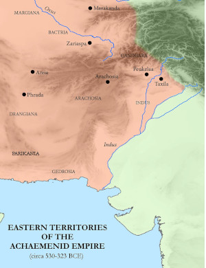
Eastern territories of the Achaemenid Empire.[2][3][46]
The names of the three Ancient Indian provinces still appear in trilingual cuneiform labels above their respective figures on the tomb of Artaxerxes II (c.358 BCE).[47][48][49]
The nature of the administration under the Achaemenids is uncertain. Even though the Indian provinces are called "satrapies" by convention, there is no evidence of there being any satraps in these provinces. When Alexander invaded the region, he did not encounter Achaemenid satraps in the Indian provinces, but local Indian rulers referred to as hyparchs ("Vice-Regents"), a term that connotes subordination to the Achaemenid rulers.[50] The local rulers may have reported to the satraps of Bactria and Arachosia.[50]
Achaemenid lists of Provinces
Darius I listed three Indian provinces: Sattagydia (Thataguš), Gandāra (Gandhara) and Hidūš (Sind),[29] in which "Sind" should be understood as "Indus Valley".[51]
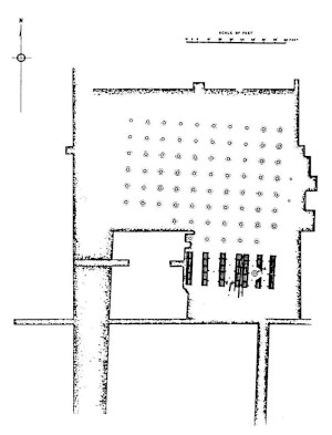
Gandhara included the entire Peshawar Valley which was bound by the Swat District in the north, Afghanistan in the West, the Indus River to the south east, and Kohat District in the south.[52] The capital of the Gandhara satrapy was Pushkalavati. Archeological excavations of Pushkalavati were conducted by Mortimer Wheeler in 1962 who discovered structures built during the Achaemenid period as well as artifacts.[52]
The Achaemenid Satrapy of Hindush incorporated the Greater Punjab region in the Indus Valley. It was bound by the Hazara region to the north, the Indus River to the west, and the Jhelum River in the south and east. The satrapy's capital was Bhir Mound in Takshashila (Taxila).[53] Bhir Mound was excavated by John Marshall between 1913 and 1934. Fortified structures and canals were found dating to the Achaemenid period, as well as ornamental jewelry.[53]
The three regions remained represented among Achaemenid Provinces on all the tombs of the Achaemenid rulers after Darius, except for the last ruler Darius III who was vanquished by Alexander at Gaugamela, suggesting that the Indians were under Achaemenid dominion at least until 338 BCE, date of the end of the reign of Artaxerxes III, before the accession of Darius III, that is, less than 10 years before the campaigns of Alexander in the East and his victory at Gaugamela.[50] The last known appearance of Gandhara in name as an Achaemenid province is on the list of the tomb of Artaxerxes II, circa 358 BCE, date of his burial.[47][48][49]
List of Herodotus
Herodotus (III-91 and III-94), gives a list with a slightly different structure, as some province which are presented separately in the Achaemenid inscriptions are grouped together by Herodotus when he described the tribute paid by each territory.[54][55][56] Herodotus presents Indos ([x]) as "the 20th province", while "the Sattagydae, Gandarii, Dadicae, and Aparytae" together form "the 7th Province".[56] According to historian A. T. Olmstead, the fact that some Achaemenid regions are grouped together in this list may have represented some loss of territory.[57]
The Hindūš province, remained loyal till Alexander's invasion.[58] Circa 400 BC, Ctesias of Cnidus related that the Persian king was receiving numerous gifts from the kings of "India" (Hindua).[29][a] Ctesias also reported Indian elephants and Indian mahouts making demonstrations of the elephant's strength at the Achaemenid court.[60]
By about 380 BC, the Persian hold on the region was weakening, but the area continued to be a part of the Achaemenid Empire until Alexander's invasion.[61]
Darius III (c. 380 – July 330 BC) still had Indian units in his army, albeit very few in comparison to his predecessors.[29] In particular he had 15 war elephants at the Battle of Gaugamela for his fight against Alexander the Great.[62]
Indian soldiers on the tomb of Darius I (c.500 BCE)
Indian soldiers on the tomb of Xerxes I (c.480 BCE)
Indian soldiers on the tomb of Artaxerxes I (c.430 BCE)
Indian soldiers on the tomb of Darius II (c.410 BCE)
Indian soldiers on the tomb of Artaxerxes II (c.370 BCE)
Indian soldiers on the tomb of Artaxerxes III (c.340 BCE)
Indian tributes
Apadana Palace
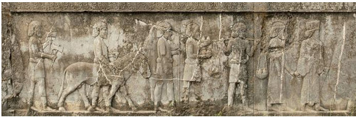
Hindush Tribute Bearers on the Apadana Staircase 8, circa 500 BCE.
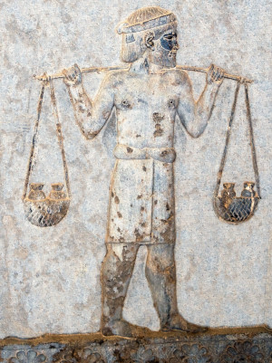
A small but heavy load: Indian tribute bearer at Apadana, probably carrying gold dust.[63] 1 liter of gold weighs 19.3kg.
The reliefs at the Apadana Palace in Persepolis describe tribute bearers from 23 satrapies visiting the Achaemenid court. These are located at the southern end of the Apadana Staircase. Among the foreigners the Arabs, the Thracians, the Bactrians, the Indians (from the Indus valley area), the Parthians, the Cappadocians, the Elamites or the Medians. The Indians from the Indus valley are bare-chested, except for their leader, and barefooted and wear the dhoti. They bring baskets with vases inside, carry axes, and drive along a donkey.[64] One man in the Indian procession carries a small but visibly heavy load of four jars on a yoke, suggesting that he was carrying some of the gold dust paid by the Indians as tribute to the Achaemenid court.[63]
According to the Naqsh-e Rustam inscription of Darius I (circa 490 BCE), there were three Achaemenid Satrapies in the subcontinent: Sattagydia, Gandara, Hidus.[42][65]
Tribute payments
See also: Districts of the Achaemenid Empire
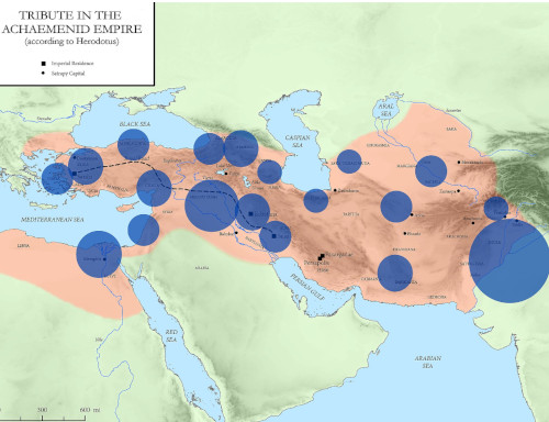
Volume of annual tribute per district, in the Achaemenid Empire, according to Herodotus.[66][67][29]
The conquered area was the most fertile and populous region of the Achaemenid Empire. An amount of tribute was fixed according to the richness of each territory.[68][66] India was already fabled for its gold.
Herodotus (who makes several comments on India) published a list of tribute-paying nations, classifying them in 20 Provinces.[69][56] The Province of Indos ([x], the Indus valley) formed the 20th Province, and was the richest and most populous of the Achaemenid Provinces.
The Indians ( Ἰνδῶν) made up the twentieth province. These are more in number than any nation known to me, and they paid a greater tribute than any other province, namely three hundred and sixty talents of gold dust.
— Herodotus, III 94.[56]
According to Herodotus, the "Indians" ('[x], Indoi)[70]), as separate from the Gandarei and the Sattagydians, formed the 20th taxation Province, and were required to supply gold dust in tribute to the Achaemenid central government for an amount of 360 Euboean talents (equivalent to about 8300 kg or 8.3 tons of gold annually, a volume of gold that would fit in a cube of side 75 cm).[68][66] The exchange rate between gold and silver at the time of Herodotus being 13 to 1, this was equal in value to the very large amount of 4680 Euboean talents of silver, equivalent to 3600 Babylonian talents of silver (equivalent in value to about 108 tons of silver annually).[68][66] The country of the "Indians" ('[x] Indoi) was the Achaemenid district paying the largest tribute, and alone represented 32% of the total tribute revenues of the whole Achaemenid Empire.[68][66][29] It also means that Indos was the richest Achaemenid region in the subcontinent, much richer than Gandara or Sattagydia.[29] However the amount of gold in question is quite enormous, so there is a possibility that Herodotus was mistaken and that his own sources actually only meant something like the gold equivalent of 360 Babylonian talents of silver.[22]
Gandaran delegation at Apadana Palace.
The territories of Gandara, Sattagydia, Dadicae (north-west of the Kashmir Valley) and the Aparytae (Afridis) are named separately, and were aggregated together for taxation purposes, forming the 7th Achaemenid Province, and paying overall a much lower tribute of 170 talents together (about 5151 kg, or 5.1 tons of silver), hence only about 1.5% of the total revenues of the Achaemenid Empire:[68][66]
The Sattagydae ([x]), Gandarii (Γανδάριοι), Dadicae, and Aparytae (Ἀπαρύται) paid together a hundred and seventy talents; this was the seventh province
— Herodotus, III 91.[56]
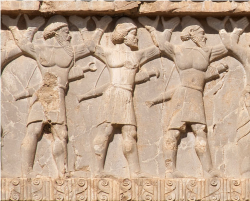
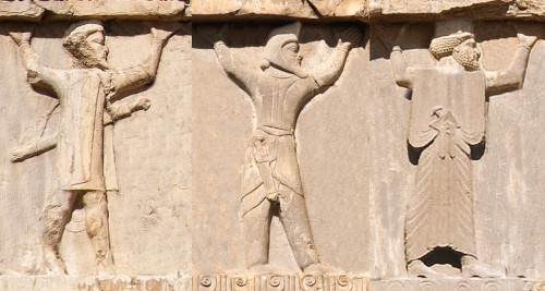
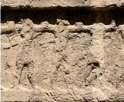
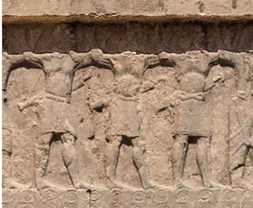
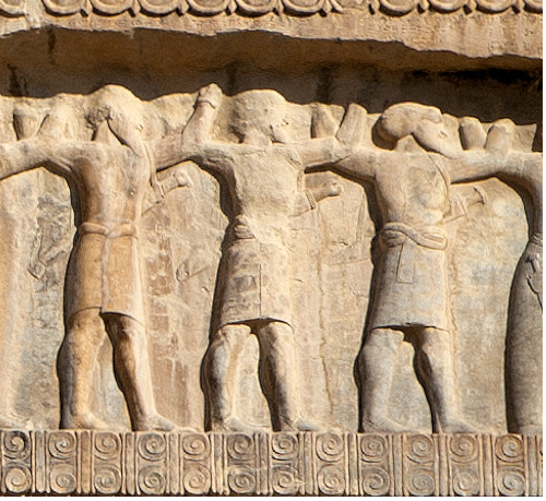
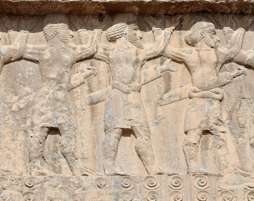
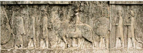
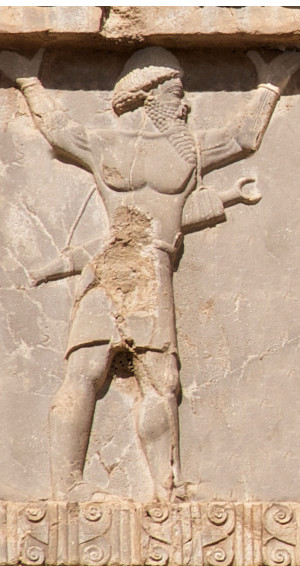
Ancient Indian soldiers of the three territories of Sattagydia, Gandhara and Hindush respectively,[71] supporting the throne of Xerxes I on his tomb at Naqsh-e Rostam.[72][73] See also complete relief. c. 480 BCE.
Indian soldiers of the Achaemenid army participated to the Second Persian invasion of Greece (480-479 BCE).
The Indians also supplied Yaka wood (teak) for the construction of Achaemenid palaces,[74][65] as well as war elephants such as those used at Gaugamela.[65] The Susa inscriptions of Darius explain that Indian ivory and teak were sold on Persian markets, and used in the construction of his palace.[1]
Contribution to Achaemenid war efforts
Second Persian invasion of Greece (480-479 BCE)
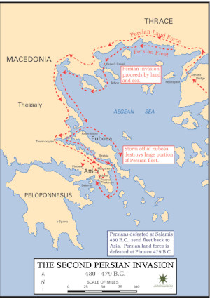
Indians were employed in the Achaemenid army of Xerxes in the Second Persian invasion of Greece (480-479 BCE). All troops were stationed in Sardis, Lydia, during the winter of 481-480 BCE to prepare for the invasion.[75][76] In the spring of 480 BCE "Indian troops marched with Xerxes's army across the Hellespont".[16][77] It was the "first-ever force from India to fight on the continent of Europe", storming Greek troops at the Battle of Thermopylae in 480 BCE, and fighting as one of the main nations until the final Battle of Platea in 479 BCE.[78][79][80]
Herodotus, in his description of the multi-ethnic Achaemenid army invading Greece, described the equipment of the Indians:[77]
The Indians wore garments of tree-wool, and carried bows of reed and iron-tipped arrows of the same. Such was their equipment; they were appointed to march under the command of Pharnazathres son of Artabates.
— Herodotus VII 65
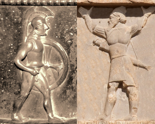
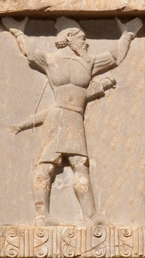
Probable Spartan hoplite (Vix crater, c. 500 BCE),[81] and a Hindush warrior of the Achaemenid army[82][83] (tomb of Xerxes I, c. 480 BCE), at the time of the Second Persian invasion of Greece (480–479 BCE).
Herodotus also explains that the Indian cavalry under the Achaemenids had an equipment similar that of their foot soldiers:
The Indians were armed in like manner as their foot; they rode swift horses and drove chariots drawn by horses and wild asses.
— Herodotus VII 86
The Gandharis had a different equipment, akin to that of the Bactrians:
The Bactrians in the army wore a headgear most like to the Median, carrying their native bows of reed, and short spears. (...) The Parthians, Chorasmians, Sogdians, Gandarians, and Dadicae in the army had the same equipment as the Bactrians. The Parthians and Chorasmians had for their commander Artabazus son of Pharnaces, the Sogdians Azanes son of Artaeus, the Gandarians and Dadicae Artyphius son of Artabanus.
— Herodotus VII 64-66
Destruction of Athens and Battle of Plataea (479 BCE)
After the first part of the campaign directly under the orders Xerxes I, the Indian troops are reported to have stayed in Greece as one of the 5 main nations among the 300,000 elite troops of General Mardonius. They fought in the last stages of the war, took part in the Destruction of Athens, but were finally vanquished at the Battle of Platea:[84]
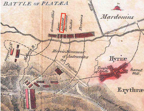
Indian corps at the Battle of Plataea, 479 BCE.
Mardonius there chose out first all the Persians called Immortals, save only Hydarnes their general, who said that he would not quit the king's person; and next, the Persian cuirassiers, and the thousand horse, and the Medes and Sacae and Bactrians and Indians, alike their footmen and the rest of the horsemen. He chose these nations entire; of the rest of his allies he picked out a few from each people, the goodliest men and those that he knew to have done some good service... Thereby the whole number, with the horsemen, grew to three hundred thousand men.
— Herodotus VIII, 113.[85][84]
At the final Battle of Platea in 479 BCE, Indians formed one of the main corps of Achaemenid troops (one of "the greatest of the nations").[79][80][78][86] They were one of the main battle corps, positioned near the center of the Achaemenid battle line, between the Bactrians and the Sakae, facing against the enemy Greek troops of "Hermione and Eretria and Styra and Chalcis".[87][79] According to modern estimates, the Bactrians, Indians and Sakae probably numbered about 20,000 men altogether, whereas the Persian troops on their left amounted to about 40,000.[88] There were also Greek allies of the Persians, positioned on the right, whom Herodotus numbers at 50,000, a number which however might be "extravagant",[88] and is nowadays estimated to around 20,000.[89] Indians also supplied part of the cavalry, the total of which was about 5,000.[90][89]
Depictions
Indian soldiers of the three territories of Gandara, Sattagydia (Tathagatus) and Hindush are shown, together with soldiers of all the other nations, supporting the throne of their Achaemenid ruler, at Naqsh-e Rostam on the tombs of Darius I, Xerxes I, Artaxerxes I and Darius II, and at Persepolis on the tombs of Artaxerxes II and Artaxerxes III. The last Achaemenid ruler Darius III never had time to finish his own tomb due to his hasty defeat by Alexander the Great, and therefore does not have such depictions.[50][73] The soldiers from India are characterized by their particular clothing, only composed of a loin cloth and sandals, with bare upper body, in contrast to all the other ethnicities of the Achaemenid army, who are fully clothed, and in contrast also to the neighbouring provinces of Bactria or Arachosia, who are also fully clothed.[50]
The three types of Indian soldiers still appear (upper right corner) among the soldiers of the Achaemenid Empire on the tomb of Artaxerxes III (who died in 338 BCE).[50][73][91]
The presence of the three ethnicities of Indian soldiers on all the tombs of the Achaemenid rulers after Darius, except for the last ruler Darius III who was vanquished by Alexander at Gaugamela, suggests that the Indians were under Achaemenid dominion at least until 338 BCE, the date of the end of the reign of Artaxerxes III, before the accession of Darius III, that is, less than 10 years before the campaigns of Alexander in the East and his victory at Gaugamela.[50]
Indians at the Battle of Gaugamela (331 BCE)
According to Arrian, Indian troops were still deployed under Darius III at the Battle of Gaugamela (331 BCE). He explains that Darius III "obtained the help of those Indians who bordered on the Bactrians, together with the Bactrians and Sogdianians themselves, all under the command of Bessus, the Satrap of Bactria".[50] The Indians in questions were probably from the area of Gandara.[50] Indian "hill-men" are also said by Arrian to have joined the Arachotians under Satrap Barsentes, and are thought to have been either the Sattagydians or the Hindush.[50]
Fifteen Indian war elephants were also part of the army of Darius III at Gaugamela.[62] They had specifically been brought from India.[92] Still, it seems they did not participate to the final battle, probably because of fatigue.[62] This was a relief for the armies of Alexander, who had no previous experience of combat against war elephants.[93] The elephants were captured with the baggage train by the Greeks after the engagement.[94]
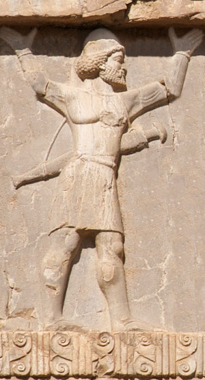
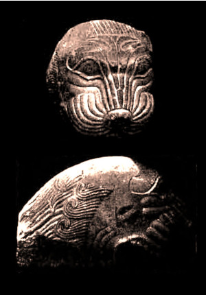
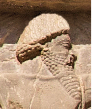
Gandaran soldier of the Achaemenid army, circa 480 BCE. Xerxes I tomb.
Gandaran soldier (enhanced detail).
Sattagydian soldier of the Achaemenid army, circa 480 BCE. Xerxes I tomb.
Sattagydian soldier (enhanced detail).
Hindush soldier of the Achaemenid army, circa 480 BCE. Xerxes I tomb.
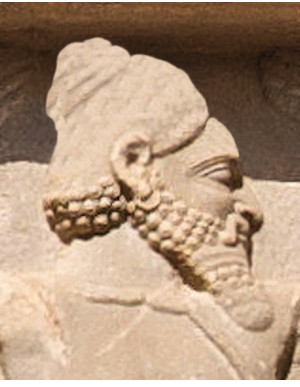
Hindush soldier (enhanced detail).
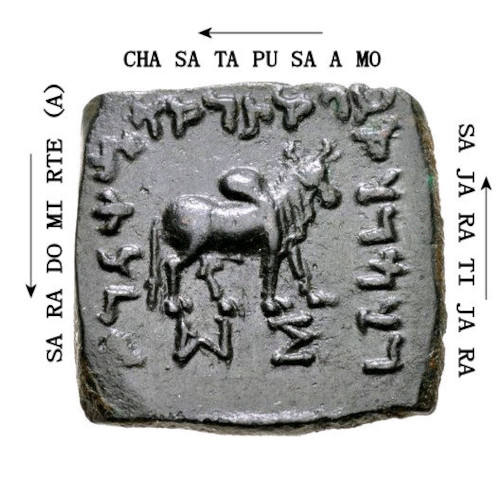
Greek and Achaemenid coinage
See also: Ancient Greek coinage and Achaemenid coinage
Strike of an Achaemenid siglos, Kabul, Afghanistan, circa 5th century BCE. Archer king type. Coins of this type were also found in the Bhir Mound hoard in Taxila.[95]
Achaemenid Empire coin minted in the Kabul Valley. Circa 500-380 BCE.[96][97]
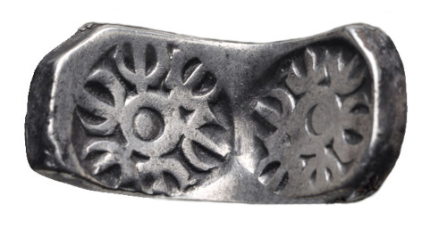
"Bent bar" minted under Achaemenid administration, of the type found in large quantities in the Chaman Hazouri hoard and the Bhir Mound hoard in Taxila.[98][99]
Coins found in the Chaman Hazouri hoard in Kabul, the Shaikhan Dehri hoard in Pushkalavati in Gandhara, near Charsadda, as well as in the Bhir Mound hoard in Taxila, have revealed numerous Achaemenid coins as well as many Greek coins from the 5th and 4th centuries BCE. These circulated in the area, at least as far as the Indus during the reign of the Achaemenids, who were in control of the areas as far as Gandhara.[100][101][97][102]
Kabul and Bhir Mound hoards
See also: Kabul hoard
The Kabul hoard, also called the Chaman Hazouri, Chaman Hazouri or Tchamani-i Hazouri hoard,[100] is a coin hoard discovered in the vicinity of Kabul, Afghanistan. The hoard, discovered in 1933, contained numerous Achaemenid coins as well as many Greek coins from the 5th and 4th centuries BCE.[97] Approximately one thousand coins were in the hoard.[100][101] The hoard is dated to approximately 380 BCE as no coins in the hoard were later than that date.[103]
This numismatic discovery has been very important in studying and dating the history of coinage of India, since it is one of the very rare instances when punch-marked coins can actually be dated, due to their association with known and dated Greek and Achaemenid coins in the hoard.[104] The hoard supports the view that punch-marked coins existed in 360 BCE, as suggested by literary evidence.[104]
Daniel Schlumberger also considers that punch-marked bars, similar to the many punch-marked bars found in north-western India, initially originated in the Achaemenid Empire, rather than in the Indian heartland:
"The punch-marked bars were up to now considered to be Indian (...) However the weight standard is considered by some expert to be Persian, and now that we see them also being uncovered in the soil of Afghanistan, we must take into account the possibility that their country of origin should not be sought beyond the Indus, but rather in the oriental provinces of the Achaemenid Empire"
— Daniel Schlumberger, quoted from Trésors Monétaires, p.42.[102]
Modern numismatists now tend to consider the Achaemenid punch-marked coins as the precursors of the Indian punch-marked coins.[105][106]
Pushkalavati hoard
See also: Shaikhan Dehri hoard
In 2007, a small coin hoard was discovered at the site of ancient Pushkalavati (the Shaikhan Dehri hoard) near Charsada in Pakistan. The hoard contained a tetradrachm minted in Athens circa 500/490-485/0 BCE, typically used as a currency for trade in the Achaemenid Empire, together with a number of local types as well as silver cast ingots. The Athens coin is the earliest known example of its type to be found so far to the east.[107][108]
According to Joe Cribb, these early Greek coins were at the origin of Indian punch-marked coins, the earliest coins developed in India, which used minting technology derived from Greek coinage.[97]