CHAPTER 15
Destroying and transporting effects of Tides and Currents – Shifting of their position – Differences in the rise of the tides – Causes of currents – Action of the sea on the British coast – Shetland Islands – Large blocks removed – Effects of lightning – Breach caused in a mass of porphyry – Isles reduced to clusters of rocks – Orkney Isles – East coast of Scotland – Stones thrown up on the Bell Rock – East coast of England – Waste of the cliffs of Holderness, Norfolk, and Suffolk – Silting up of Estuaries – Origin of submarine forests – Yarmouth estuary – Submarine forests – Suffolk coast – Dunwich – Essex coast – Estuary of the Thames – Goodwin Sands – Coast of Kent – Formation of Straits of Dover – Coast of Hants – Coast of Dorset – Portland – Origin of the Chesel Bank – Cornwall – Lionnesse tradition – Coast of Brittany
ALTHOUGH the movements of great bodies of water, termed tides and currents, are in general due to very distinct causes, we cannot consider their effects separately, for they produce, by their joint action, those changes which are subjects of geological inquiry. We may view these forces as we before considered rivers, first, as employed in destroying portions of the solid crust of the earth, and removing them to other localities; secondly, as reproductive of new strata. Some of the principal currents which traverse large regions of the globe depend on permanent winds, and these on the rotation of the earth on its axis, and its position in regard to the sun: -- they are causes, therefore, as constant as the tides themselves, and, like them, depend on no temporary or accidental circumstances, but on the laws which preside over the motions of the heavenly bodies. But, although the sum of their influence in altering the surface of the earth may be very constant throughout successive epochs. yet the points where these operations are displayed in the fullest energy shift perpetually. The height to which the tides rise, and the violence and velocity of currents, depend in a great measure on the actual configuration of the land, the contour of a long line of continental or insular coast, the depth and breadth of channels, the peculiar form of the bottom of seas-in a word, on a combination of circum. stances which are made to vary continually by many igneous and aqueous causes, and, among the rest, by tides and currents. Although these agents, therefore, of decay and reproduction, are local in reference to periods of short duration, such as those which history in general embraces, they are nevertheless universal, if we extend our views to a sufficient lapse of ages.
The tides, as is well known, rise in certain channels, bays, and estuaries, to an elevation far above the average height of the same tides in more open parts of the coast, or on islands in the main ocean. In all lakes, and in most inland seas, the tides are not perceptible. In the Mediterranean, even, deep and extensive as is that sea, they are only sensible in certain localities, and they then rarely rise more than six inches above the mean level. In the Straits of Messina, however, there is an ebb and flow every six hours, to the amount of two feet, but this elevation is partly due to the peculiar set of the currents. In islands remote from the shore, the rise of the tides is slight, as at St. Helena, for example, where it rarely exceeds three feet. [1] In the estuary of the Severn, the rise at King's Road near Bristol is forty-two feet; and at Chepstow on the Wye, a small river which opens into the same estuary, about fifty feet. All the intermediate elevations may be found at different places on our coast. Thus, at Milford Haven, the rise is thirty-six feet; at London, and the promontory of Beachy Head, eighteen feet; at the Needles, in the Isle of Wight, nine feet; at Weymouth, seven; at Lowestoff about five; at Great Yarmouth, still less.
That movements of no inconsiderable magnitude should be impressed on an expansive ocean, by winds blowing for many months in one direction, may easily be conceived, when we observe the effects produced in our own seas by the temporary action of the same cause. It is well known that a strong southwest or north-west wind, invariably raises the tides to an unusual height along the east coast of England, and in the Channel; and that a north-west wind of any continuance causes the Baltic to rise two feet and upwards above its ordinary level. Smeaton ascertained, by experiment, that in a canal four miles in length, the water was kept up four inches higher at one end than at the other, merely by the action of the wind along the canal; and Rennel informs us, that a large piece of water, ten miles broad, and generally only three feet deep, has, by a strong wind, had its waters driven to one side, and sustained so as to become six feet deep, while the windward side was laid dry. [2] As water, therefore, he observes, when pent up so that it cannot escape, acquires a higher level, so, in a place where it can escape, the same operation produces a current; and this current will extend to a greater or less distance, according to the force by which it is produced. The most extensive and best determined of all currents, is the gulf stream, which sets westward in tropical regions; and, after doubling the Cape of Good Hope, where it runs nearly at the rate of two miles an hour, inclines considerably to the north ward, along the western coast of Africa, then crosses the Atlantic, and, having accumulated in the Gulf of Mexico, passes out at the Straits of Bahama, with a velocity of four miles an hour, which is not reduced to two miles until the stream has proceeded to the distance of eighteen hundred miles in the direction of Newfoundland: Near that island it meets with a current setting southward from Baffin's Bay, on the coast of Greenland, and is thereby deflected towards the east. One branch extends in that direction, while another runs towards the north; so that fruits, plants, and wood, the produce of America and the West Indies, are drifted to the shores of Ireland, the Hebrides, and even to Spitzbergen.
In describing the destroying effects of tides and currents, it will be necessary to enter into some detail, because we have not the advantage here, as in the case of the deltas of many rivers, of viewing the aggregate mass which has resulted from the continual transportation of matter, for many centuries, at certain points. We must infer the great amount of accumulation as a corollary from the proofs adduced of the removing force; and this it will not be difficult to show is, on the whole, greater than that of running water on the land.
If we follow the eastern and southern shores of the British islands, from our Ultima Thule in Shetland, to the Land's End in Cornwall, we shall find evidence of a series of changes since the historical era, very illustrative of the kind and degree of force exerted by the agents now under consideration. In this survey we shall have an opportunity of tracing the power of the sea on islands, promontories, bays, and estuaries; on bold, lofty cliffs as well as on low shores; and on every description of rock and soil, from granite to blown sand. We shall afterwards explain by reference to other regions, some phenomena of which our own coast furnishes no examples.
Shetland Islands. -- The northernmost group of the British islands, the Shetland, are composed of a great variety of primary and trap rocks, including granite, gneiss, mica-slate, serpentine, greenstone, and many others, with some secondary rocks, chiefly sandstone and conglomerate. These isles are exposed continually to the uncontrolled violence of the Atlantic, for no land intervenes between their western shores and America. The prevalence, therefore, of strong westerly gales, causes the waves to be sometimes driven with irresistible force upon the coast, while there is also a current setting from the north. The spray of the sea aids the decomposition of the rocks, and prepares them to be breached by the mechanical force of the waves. Steep cliffs are hollowed out into deep caves and lofty arches; and almost every promontory ends in a cluster of rocks, imitating the forms of columns, pinnacles, and obelisks. Modern observations show that the reduction of continuous tracts to such insular masses is a process in which Nature is still actively engaged. "The Isle of Stenness," says Dr. Hibbert, "presents a scene of unequalled desolation. In stormy winters, huge blocks of stones are overturned, or are removed from their native beds, and hurried up a slight acclivity to a distance almost incredible. In the winter of 1802, a tabular-shaped mass, eight feet two inches by seven feet, and five feet one inch thick, was dislodged from its bed, and removed to a distance of from eighty to ninety feet. I measured the recent bed from which a block had been carried away the preceding winter (A. D. 1818), and found it to be seventeen feet and a half by seven feet, and the depth two feet eight inches. 'The removed mass had been borne to a distance of thirty feet, when it was shivered into thirteen or more lesser fragments, some of which were carried still farther, from thirty to one hundred and twenty feet. A block, nine feet two inches by six feet and a half, and four feet thick, was hurried up the acclivity to a distance of one hundred and fifty feet." [3]
At Northmavine, also, angular blocks of stone have been removed in a similar manner to considerable distances, by the waves of the sea, [4] some of which are represented in the annexed figure, No. 7.
No. 7. Stony fragments drifted by the sea. Northmavine, Shetland.
In addition to numerous examples of masses detached and driven by the tides and currents from their place, some remarkable effects of lightning are recorded in these isles. At Funzie, in Fetlar, about the middle of the last centuy, a rock of mica schist, one hundred and five feet long, ten feet broad, and in some places four feet thick, was in an instant torn by a flash of lightning from its bed, and broken into three large, and several lesser fragments. One of these, twenty-six feet long, ten feet broad, and four feet thick, was simply turned over. The second, which was twenty-eight feet long, seventeen broad, and five feet in thickness, was hurled across a high point to the distance of fifty yards. Another broken mass, about forty feet long, was thrown still farther, but in the same direction, quite into the sea. There were also many lesser fragments scattered up and down. [5]
When we thus see electricity co-operating with the violent movements of the ocean in heaping up piles of shattered rocks on dry land, and beneath the waters, we cannot but admit that a region which shall be the theatre, for myriads of ages, of the action of such disturbing causes, will present, at some future period, a scene of havoc and ruin that may compare with any now found by the geologist on the surface of our continents; raised as they all have been in former ages from the bosom of the deep. We have scarcely begun, as yet, to study the effects of a single class of the mighty instruments of change and disorder now operating on our globe; and yet geologists have presumed to resort to a nascent order of things, or to revolutions in the economy of Nature, to explain every obscure phenomenon!
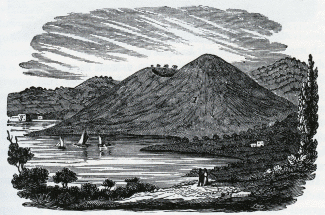
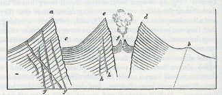
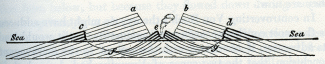
In some of the Shetland Isles, as on the west of Meikle Roe, dikes, or veins of soft granite have mouldered away; while the matrix in which they were inclosed, being of the same substance, but of a firmer texture, has remained unaltered. Thus, long narrow ravines, sometimes twenty feet wide, are laid open, and often give access to the waves. After describing some huge cavernous apertures into which the sea flows for two hundred and fifty feet in Roeness, Dr. Hibbert enumerates other ravages of the ocean. "A mass of rock, the average dimensions of which may perhaps be rated at twelve or thirteen feet square, and four and a half or five in thickness, was first moved from its bed, about fifty years ago, to a distance of thirty feet, and has since been twice turned over. But the most sublime scene is where a mural pile of porphyry, escaping the process of disintegration that is devastating the coast, appears to have been left as a sort of rampart against the inroads of the ocean; -- the Atlantic, when provoked by wintry gales, batters against it with all the force of real artillery -- the waves having, in their repeated assaults, forced themselves an entrance. This breach, named the Grind of the Navir (No. 8), is widened every winter by the overwhelming surge that, finding a passage through it, separates large stones from its sides, and forces them to a distance of no less than one hundred and eighty feet. In two or three spots, the fragments which have been detached are brought together in immense heaps, that appear as an accumulation of cubical masses, the product of some quarry." [6]
No. 8. Grind of the Navir -- Passage forced by the sea through rocks of hard porphyry.
It is evident from this example, that although the greater indestructibility of some rocks may enable them to withstand, for a longer time, the action of the elements, yet they cannot permanently resist. There are localities in Shetland, in which rocks of almost every variety of mineral composition are suffering disintegration: thus the sea makes great inroads on the clay slate of Fitfel Head, on the serpentine of the Vord Hill in Fetlar, and on the mica--schist of the Bay of Triesta, on the east coast of the same isle, which decomposes in angular blocks. The quartz rock on the east of Walls, and the gneiss and mica-schist of Garthness, suffer the same fate.
Such devastation cannot be incessantly committed for thousands of years without dividing islands, until they become at last mere clusters of rocks, the last shreds of masses once continuous. To this state many appear to have been reduced, and innumerable fantastic forms are assumed by rocks adjoining these isles, to which the name of Drongs is applied, as it is to those of similar shape in Feroe.
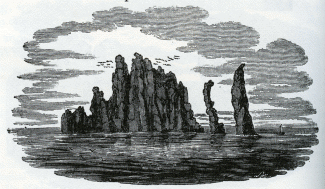
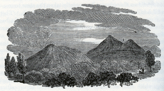
No. 9. Granitic rocks named the Drongs, between Papa Stour and Hillswick Ness
The granitic rocks (No. 9) between Papa Stour and Hillswick Ness afford an example. A still more singular cluster of rocks is seen to the south of Hillswick Ness (No. 10), which presents a variety of forms as viewed from different points, and has often been likened to a small fleet of vessels with spread sails. [7]

No. 10. Granitic Rocks to the south of Hillswick Ness, Shetland.
We may imagine that in the course of time Hillswick Ness itself may present a similar wreck, from the unequal decomposition of the rocks whereof it is composed, consisting of gneiss and mica schist, traversed in all directions by veins of felspar porphyry.
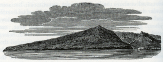
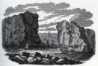
Midway between the groups of Shetland and Orkney is Fair Island, said to be composed of sandstone with high perpendicular cliffs. The current runs with such velocity, that during a calm, and when there is no swell, the rocks on its shores are white with the foam of the sea driven against them. The Orkneys, if carefully examined, would probably afford as much illustration of our present topic as the Shetland Islands. The north-east promontory of Sanda, one of these isles, has been cut off in modern times by the sea, so that it became what is now called Start Island, where a lighthouse was erected in 1807, since which time the new strait has grown broader.
East Coast of Scotland. -- To pass over to the main land of Scotland, we find that, in Inverness-shire, there have been inroads of the sea at Fort George, and others in Murrayshire, which have swept away the old town of Findhorn. On the coast of Kincardineshire, an illustration was afforded, at the close of the last century, of the effect of promontories in protecting a line of low shore. The village of Mathers, two miles south of Johnshaven, was built on an ancient shingle beach, protected by a projecting ledge of limestone rock. This was quarried for lime to such an extent, that the sea broke through, and in 1795 carried away the whole village in one night, and penetrated one hundred and fifty yards inland, where it has maintained its ground ever since, the new village having been built farther inland on the new shore. In the Bay of Montrose, we find the North Esk and the South Esk rivers pouring annually into the sea large quantities of sand and pebbles, yet they have formed no deltas; for the tides scour out the channels, and the current, setting across their mouths, sweeps away all the materials. Considerable beds of shingle, brought down by the North Esk, are seen along the beach. Proceeding southwards, we find that at Arbroath, in Forfarshire, which stands on a rock of red sandstone, gardens and houses have been carried away within the last thirty years by encroachments of the sea. It has become necessary to remove the lighthouses at the mouth of the estuary of the Tay, in the same county, at Button Ness, which were built on a tract of blown sand, the sea having encroached for three-quarters of a mile.
A good illustration was afforded, during the building of the Bell Rock Lighthouse, at the mouth of the Frith of Tay, of the power which currents in estuaries can exert at considerable depths, in scouring out the channel. The Bell Rock is a sunken reef, consisting of red sandstone, being from twelve to sixteen feet under the surface at high water, and about twelve miles from the main land. At the distance of one hundred yards, there is a depth, in all directions, of two or three fathoms at low water. The perpendicular rise and fall of the spring-tides is fifteen feet, and at neap-tides, eight feet; their velocity varying from one to three miles per hour. In 1801, during the erection of the lighthouse, six large blocks of granite, which had been landed on the reef, were removed by the force of the sea, and thrown over a rising ledge to the distance of twelve or fifteen paces; and an anchor, weighing about 22 cwt., was thrown up upon the rock. [8] Mr. Stevenson informs us moreover, that drift-stones, measuring upwards of thirty cubic feet, or more than two tons weight, have, during storms, been often thrown upon the rock from the deep water. [9]
Among the proofs that the sea has encroached both in the estuaries of the Tay and Forth, may be mentioned the submarine forests which have been traced for several miles by Dr. Fleming, along the margins of those estuaries on the north and south shores of the county of Fife. [10] The alluvial tracts, however, on which such forests grow, generally occupy spaces which may be said to be in dispute between the river and the sea, and to be alternately lost and won. Estuaries (a term which we confine to inlets entered both by rivers and tides of the sea) have a tendency to become silted up in parts; but the same tracts, after remaining dry, perhaps, for thousands of years, are again liable to be overflowed, for they are always low, and, if inhabited, must generally be secured by artificial embankments. Meanwhile the sea devours, as it advances, the high as well as the low parts of the coast, breaking down, one after another, the rocky bulwarks which protect the mouths of estuaries. The changes of territory, therefore, within the general line of coast are all of a subordinate nature, in no way tending to arrest the march of the great ocean, nor to avert the destiny eventually awaiting the whole region; they are like the petty wars and conquests of the independent states and republics of Greece, while the power of Macedon was steadily pressing on, and preparing to swallow up the whole.
On the coast of Fife, at St. Andrew's, a tract of land which intervened between the castle of Cardinal Beaton and the sea has been entirely swept away, as were the last remains of the Priory of Crail, in the same county, in 1803. On both sides of the Frith of Forth, land has been consumed; at North Berwick in particular, and at Newhaven, where an arsenal and dock, built in the reign of James IV., in the fifteenth century has been overflowed.
East Coast of England. -- If we now proceed to the English coast, we find records of numerous lands having been destroyed in Northumberland, as those near Banborough and Holy Island, and at Tynemouth Castle, which now overhangs the sea, although formerly separated from it by a strip of land. At Hartlepool, and several other parts of the coast of Durham composed of magnesian limestone, the sea has made considerable inroads. Almost the whole coast of Yorkshire, from the mouth of the Tees to that of the Humber, is in a state of gradual dilapidation. That part of the cliffs which consists of lias, the oolite series, and chalk, decays slowly. They present abrupt and naked precipices, often three hundred feet in height; and it is only at a few points that the grassy covering of the sloping talus marks a ~temporary relaxation of the erosive action of the sea. The chalk cliffs are washed into caves in the projecting headland of Flamborough, where they are decomposed by the salt vapours, and slowly crumble away. But the waste is most rapid between that promontory and Spurn Point, or the coast of Holderness, as it is called. This tract consists chiefly of beds of clay, gravel, sand, and chalk rubble. The irregular intermixture of the argillaceous beds causes many springs to be thrown out, and this facilitates the undermining process, the waves beating against them, and a strong current setting chiefly from the north. The wasteful action is very conspicuous at Dimlington Height, the loftiest point in Holderness, where the beacon stands on a cliff one hundred and forty-six feet above high water, the whole being composed of clay, with pebbles scattered through it. [11]
In the old maps of Yorkshire, we find spots, now sandbanks in the sea, marked as the ancient sites of the towns and villages of Auburn, Hartburn, and Hyde. "Of Hyde," says Pennant, "only the tradition is left; and near the village of Hornsea, a street called Hornsea Beck has long since been swallowed." [12] Owthorne and its church have also been in great part destroyed, and the village of Kilnsea; but these places are now removed farther inland. The rate of enroachment at Owthorne, at present, is about four yards a year. [13] Not unreasonable fears are entertained that at some future time the Spurn Point will become an island, and that the ocean, entering into the estuary of the Humber, will cause great devastation. [14] Pennant, after speaking of the silting up of some ancient ports in that estuary, observes, " But, in return, the sea has made most ample reprisals; the site, and even the very names of several places, once towns of note upon the Humber, are now only recorded in history; and Ravensper was at one time a rival to Hull (Madox, Ant. Exch. i., 422), and a port so very considerable in 1332, that Edward Balliol and the con· federated English barons sailed from hence to invade Scotland; and Henry IV., in 1399, made choice of this port to land at, to effect the deposal of Richard II., yet the whole of it has long since been devoured by the merciless ocean: extensive sands, dry at low water, are to be seen in their stead." [15]
Pennant describes Spurn Head as a promontory in the form of a sickle, and says the land, for some miles to the north, was "perpetually preyed on by the fury of the German Sea, which devours whole acres at a time, and exposes on the shores considerable quantities of beautiful amber." [16]
According to Bergmann, a strip of land, with several villages, was carried away near the mouth of the Humber in 1475. The maritime district of Lincolnshire consists chiefly of lands which lie below the level of the sea, being protected by embankments. Great parts of this fenny tract were, at some unknown period, a woody country, but were afterwards inundated, and are now again recovered from the sea. Some of the fens were embanked and drained by the Romans; but after their departure the sea returned, and large tracts were covered with beds of silt containing marine shells, now again converted into productive lands. Many dreadful catastrophes are recorded by incursions of the sea, whereby several parishes have been at different times overwhelmed.
We come next to the cliffs of Norfolk and Suffolk, where the decay is in general incessant and rapid. At Hunstanton, on the north, the undermining of the lower arenaceous beds at the-foot of the cliff causes masses of red and white chalk to be precipitated from above. Between Hunstanton and Weybourne, low hills, or dunes, of blown sand, are formed along the shore, from fifty to sixty feet high. They are composed of dry sand, bound in a compact mass by the long creeping roots of the plant called Marram (Arundo arenaria). Such is the present set of the tides, that the harbours of Clay, Wells, and other places, are securely defended by these barriers; affording a clear proof that it is not the strength of the material at particular points that determines whether the sea shall be progressive or stationary, but the general contour of the coast. The waves constantly undermine the low chalk cliffs, covered with sand and clay, between Weybourne and Sherringham, a certain portion of them being annually removed. At the latter town I ascertained, in 1829, some facts which throw light on the rate at which the sea gains upon the land. It was computed, when the present inn was built, in 1805, that it would require seventy years for the sea to reach the spot; the mean loss of land being calculated, from previous observations, to he somewhat less than one yard annually. The distance between the house and the sea was fifty yards; but no allowance was made for the slope of the ground being from the sea, in consequence of which, the waste was naturally accelerated every year, as the cliff grew lower, there being at each succeeding period less matter to remove when portions of equal area fell down. Between the years 1824 and 1829, no less than seventeen yards were swept away, and only a small garden was then left between the building and the sea. There is now a depth of twenty feet (sufficient to float a frigate) at one point in the harbour of that port, where, only forty-eight years ago, there stood a cliff fifty feet high, with houses upon it! If once in half a century an equal amount of change were produced at once by the momentary shock of an earthquake, history would be filled with records of such wonderful revolutions of the earth's surface, but, if the conversion of high land into deep sea be gradual, it excites only local attention. The flag-staff of the Preventive Service station, on the south side of this harbour, has, within the last fifteen years, been thrice removed inland, in consequence of the advance of the sea.
Farther to the south we find cliffs, composed, like those of Holderness before mentioned, of alternating strata of blue clay, gravel, loam, and fine sand. Although they sometimes exceed two hundred feet in height, the havoc made on the coast is most formidable. The whole site of ancient Cromer now forms part of the German Ocean, the inhabitants having gradually retreated inland to their present situation, from whence the sea still threatens to dislodge them. In the winter of 1825, a fallen mass was precipitated from near the lighthouse, which covered twelve acres, extending far into the sea, the cliff's being two hundred and fifty feet in height. [17] The undermining by springs has sometimes caused large portions of the upper part of the cliffs, with houses still standing upon them, to give way, so that it is impossible, by erecting breakwaters at the base of the cliffs, permanently to ward off the danger. On the same coast, the ancient villages of Shipden, Wimpwell, and Eccles, have disappeared; several manors and large portions of neighbouring parishes having, piece after piece, been swallowed up; nor has there been any intermission, from time immemorial, in the ravages of the sea along a line of coast twenty miles in length, in which these places stood. [18] Hills of blown sand, between Eccles and Winterton, have barred up and excluded the tide for many hundred years from the mouths of several small estuaries; but there are records of nine breaches, from twenty to one hundred and twenty yards wide, having been made through these, whereby immense damage was done to the low grounds in the interior. A few miles south of Happisburgh, also, are hills of blown sand, which extend to Yarmouth; and these are supposed to protect the coast, but in fact their formation proves that a temporary respite of the incursions of the sea on this part is permitted by the present set of the tides and currents. Were it otherwise, the land, as we have seen, would give way, though made of solid rock.
At Yarmouth, the sea has not advanced upon the sands in the slightest degree since the reign of Elizabeth. In the time of the Saxons, a great estuary extended as far as Norwich, which city is represented, even in the thirteenth and fourteenth centuries, as "situated on the banks of an arm of the sea." The sands whereon Yarmouth is built first became firm and habitable ground about the year 1008, from which time a line of dunes has gradually increased in height and breadth, stretching across the whole entrance of the ancient estuary, and obstructing the ingress of the tides so completely, that they are only admitted by the narrow passage which the river keeps open, and which has gradually shifted several miles to the south. The tides at the river's mouth only rise, at present, to the height of three or four feet. By the exclusion of the sea, thousands of acres in the interior have become cultivated lands; and, exclusive of smaller pools, upwards of sixty fresh water lakes have been formed, varying in depth from fifteen to thirty feet, and in extent from one acre to twelve hundred. [19] The Yare, and other rivers, frequently communicate with these sheets of water; and thus they are liable to be filled up gradually with lacustrine and fluviatile deposits, and to be converted into land covered with forests. When the sea at length returns (for as the whole coast gives way, this must inevitably happen sooner or later), these tracts will be again submerged, and submarine forests may then be found, as along the margins of many estuaries. We may easily conceive that such natural embankments as those thrown by the waves, and subsequently raised by winds, across the entrance of this river, may so shut out the tide, that inland places may become dry which, on the breaching of the barrier, might again be permanently overflowed even at low water; for the tides are now so depressed, even outside the barrier, that the river is almost in the condition of one which enters an inland sea. Were high tides to recur, the fresh-water would be ponded back during the flow, and would perhaps not entirely escape during the ebb. It has been observed, by Dr. Fleming, that the roots of the trees in several submarine forests in Scotland are in lacustrine silt. The stumps of the trees evidently occupy the position in which they formerly grew, and are sometimes from eight to ten feet below high water mark. The horizontality of the strata and other circumstances, preclude the supposition of a slide, and the countries in question have been from time immemorial free from violent earthquakes, which might have produced subsidences. He has, therefore, attributed the depression, with much probability, to the drainage of peaty soil on the removal of a seaward barrier. Suppose a lake (like one of those in the valley of the Yare,) to become a marsh, and a stratum of vegetable matter to be formed on the surface, of sufficient density to support trees. Let the outlet of the marsh be elevated a few feet only above the rise of the tide. All the strata below the level of the outlet would be kept constantly wet or in a semifluid state, but if the tides rise in the estuary, and the sea encroaches, portions of the gained lands are swept away, and the extremities of the alluvial and peaty strata, whereon the forest grew, are exposed to the sea, and at every ebb tide left dry to a depth equal to the increased fall of the tide. Much water, formerly prevented from escaping by the altitude of the outlet, now oozes out from the moist beds, -- the strata collapse and the surface of the morass instead of remaining at its original height, sinks below the level of the sea. [20]
Yarmouth does not project beyond the general line of coast which has been rounded off by the predominating current from the north-west. It must not be imagined, therefore, that the acquisition of new land fit for cultivation in Norfolk and Suffolk indicates any permanent growth of the eastern limits of our island, to compensate its reiterated losses. No delta can form on such a shore.
The cliffs of Suffolk, to which we next proceed, are somewhat less elevated than those of Norfolk, but composed of similar accumulations of alternating clay, sand, and gravel. From Gorleston in Suffolk, to within a few miles north of Lowestoff, the cliffs are slowly undermined. Near the last.. mentioned town, there is an inland cliff about sixty feet high, the talus being covered with turf and heath, between which and the sea is a low, flat tract of sand, called the Ness. which gains slowly on the sea. It does not seem difficult to account for the retreat of the sea at this point from its ancient limits, the base of the inland cliff. About a mile off Lowestoff lies the Holm Sand, the highest part of which is dry at low water. The current in the intervening passage, called Lowestoff Roads, is a back- water, wherein the tide, instead of obeying the general rule along this coast, runs nine hours towards the north, and only three towards the south. Here, therefore, we have an eddy, and the Holm Sand is a bank caused by the meeting of currents, where, as usual, sediment subsides. The channel called Lowestoff Roads is about a mile broad, and the depth varies from twenty to fifty-nine feet at low water. On one side, the current has hollowed out of the Holm Sand a deep curve, called the Hook, and on the other side precisely opposite, is the projecting point of the Ness. [21] As the points and bends of a river correspond to each other, sand-bars being thrown up at each point, and the greatest depth being where the river is wearing into the bend, so we find here a shoal increasing at the Ness, and deep water preserved in the Hook. We cannot doubt that, at a modern period in the history of this coast, the high cliffs on which Lowestoff stands, were once continuous across the space where the roadstead now is, and where we have stated the present depth to be fifty-nine feet at low water.
By the mean of thirty-eight observations, it has been found that the difference of high and low tide at Lowestoff is only five feet eight inches [22] -- a remarkably slight oscillation for our eastern coast, and which naturally suggests the inquiry whether, at other points where there are inland cliffs, the rise of the tides is below their average level.
The sea undermines the high cliffs a few miles north of Lowestoff, near Corton; as also two miles south of the same town, at Pakefield, a village which has been in part swept away during the present century. From thence to Dunwich the destruction is constant. At the distance of two hundred and fifty yards from the wasting cliff at Pakefield, the sea is sixteen feet deep at low water, and in the roadstead beyond, twenty-four feet. Of the gradual destruction of Dunwich, once the most considerable sea-port on this coast, we have many authentic records. Gardner, in his History of that borough, published in 1754, shows, by reference to documents beginning with Doomsday Book, that the cliffs at Dunwich, Southwold, Eastern, and Pakefield, have been always subject to wear away. At Dunwich, in particular, two tracts of land which had been taxed in the eleventh century, in the time of King Edward the Confessor, are mentioned, in the Conqueror's survey, made but a few years afterwards, as having been devoured by the sea. The losses, at a subsequent period, of a monastery -- at another of several churches -- afterwards of the old port -- then of four hundred houses at once -- of the church of St. Leonard, the high road, town-hall, gaol, and many other buildings, are mentioned, with the dates when they perished. It is stated that, in the sixteenth century, not one quarter of the town was left standing; yet the inhabitants retreating inland, the name was preserved, as has been the case with many other ports when their ancient site has been blotted out. There is, however, a church, of considerable antiquity, still standing, the last of twelve mentioned in some records. In 1740, the laying open of the churchyard of St. Nicholas and St. Francis, in the sea cliffs, is well described by Gardner, with the coffins and skeletons exposed to view, -- some lying on the beach, and rocked
In cradle of the rude imperious surge.