Notes to Arrian's Indica. [See translation of the Indica in the Indian Antiquary, ante, pp. 85-108. The main object of the Notes is to show how the localities, &c. mentioned m the text have been identified. In drawing them up I have derived great assistance from C. Muller's Geographi Graeci Minores, -- a work which contains the text of the Indica with notes, -- Dr. Smith's Dictionary of Classical Geography, and General Cunningham's Geography of Ancient India.]
by J.W. McCrindle, M.A., Patna College
December, 1876
Arrian, distinguished as a philosopher, a statesman, a soldier, and an historian, was born in Nicomedia, in Bithynia, towards the end of the first century. He was a pupil of the philosopher Epictetus, whose lectures he published. His talents recommended him to the favour of Antoninus Pius, by whom, he was raised to the consulship (A.D. 146). In his later years he retired to his native town, where he applied his, leisure to the composition of works on history. He died at an advanced age, in the reign of the emperor Marcus Aurelius. The work by which he is best known is his account of the Asiatic expedition of Alexander the Great, which is remarkable alike for accuracy, and the Xenophontic ease and clearness of its style. His work on India ([x] or [x]) may be regarded as a continuation of his Anabasis. It is not written, however, like the Anabasis, in the Attic dialect, but in the Ionic. The reason may have been that he wished his work to supersede the old and less accurate account of India written in Ionic by Ktesias of Knidos.
The Indica consists of three parts: -- the first gives a general description of India based chiefly on the accounts of the country given by Megasthenes and Eratosthenes (chaps. i.—xvii.); the second gives an account of the voyage made by Nearchus the Cretan from the Indus to the Pasitigris, based entirely on the narrative of the voyage written by Nearchus himself (chaps. xviii.—xlii.); the third contains a collections of proofs to show that the southern parts of the world are uninhabitable on account of the great heat (chap. xlii. to the end).
Chap. I. The river Kophen. -- Another form of the name, used by Strabo, Pliny, &c., is Kophes, -etis. It is now the Kabul river. In chap. iv. Arrian gives the names of its tributaries as the Malantos (Malamantos), Soastos, and Garroias. In the 6th book of the Mahabharata three rivers are named which probably correspond to them—the Suvastu, Gauri,, and Kamana. The Soastos is no doubt the Suvastu, and the Garaea the Gauri. Curtius and Strabo call the Suastus the Choaspes. According to Mannert the Suastus and the Garaea or Guraeus were identical. Lassen [Ind. Alterthums. (2nd ed.). II.673ff.] would, however, identify the Suastos with the modern Suwad or Svat, and the Garaeus with its tributary the Panjkora; and this this is the view adopted by General Cunningham. The Malamantos some would identify with the Choes (mentioned by Arrian, Anabasis IV. 25), which is probably represented by the modern Kameh or Khonar, the largest of the tributaries of the Kabul; others, however, with the Panjkora. General Cunningham, on the other hand, takes it to be the Bara, a tributary which joins the Kabul from the south. With regard to the name Kophes he remarks: -- "The name of Kophes is as old as the time of the Vedas in which the Kubha river is mentioned [Roth first pointed this out; -- conf. Lassen, ut sup. -- Ed.] as an affluent of the Indus; and, as it is not an Aryan word, I infer that the name must have been applied to the Kabul river before the Aryan occupation, or at least as early as B.C. 2500. In the classical writers we find the Choes, Kophes, and Choaspes rivers to the west of the Indus; and at the present day we have the kunar, the Kuram, and the Gomal rivers to the west, and the Kunihar river to the east of the Indus, -- all of which are derived from the Scythian ku, 'water.' It is the guttural form of the Assyrian hu in 'Euphrates,' and 'Eulaeus,' and of the Turki suand the Tibetan chu, all of which mean 'water' or 'river.'" Ptolemy the Geographer mentions a city called Kabara situated on the banks of the Kophen, and a people called Kabolitae.
Astakenoi and Assakenoi. -- It is doubtful whether these were the same or different tribes. It has been conjectured, from some slight resemblance in the name, that they may have been the ancestors of the Afghans. Their territory lay between the Indus and the Kophen, extending from their junction as far westward as the valley of the Guraios or Panjkora. Other tribes in these parts were the Masiani, Nysaei, and Hippasii.
Nysa, being the birth-place of Bacchus, was, as is well known, bestowed as a name on various places noted for the cultivation of the vine. General Cunningham refers its site to a point on the Kophes above its junction with the Choes. The city may, however, have existed only in fable. [Lassen, u. s. 141, 681.]
Massaka (other forms are Massaga, Masaga, and Mazaga.)—The Sanskrit Masaka, near the Gauri, already mentioned. Curtius states that it was defended by a rapid river on its eastern side. When attacked by Alexander, it held out for four days against all his assaults.
Peukelaitis (other forms—Peukelaetis, Peukolitae, Peukelaotis): —'‘The Greek name,” says General Cunningham, “of Peukelaotis or Peukolaitis was immediately derived from Pukkalaoti, which is the Pali or spoken form of the Sanskrit Pushkalavati. It is also called Peukelas by Arrian, and the people are named Peukalei by Dionysius Periegetes, which are both close transcripts of the Pali Pukkala. The form of Proklois, which is found in Arrian’s Periplus of the Erythroean Sea and also in Ptolemy’s Geography, is perhaps only an attempt to give the Hindi name of Pokhar, instead of the Sanskrit Pushkara." The same authority fixes its position at “the two large towns Parang and Charsada, which form part of the well-known Hashtnagar, or ‘eight cities,’ that are seated close together on the eastern bank of the lower Swat river.” The position indicated is nearly seventeen miles to the north-east of Peshawar. Pushkala, according to Prof. Wilson, is still represented by the modern Pekhely or Pakholi, in the neighhourhood of Peshawar. The distance of Peukelaitis from Taxila (now represented by the vast ruins of Manikyala) is given by Pliny at sixty miles.
CHAP. II.-- Parapamisos (other forms— Paropamisos, Paropamissos, Paropanisos). This denotes the great mountain range now called Hindu Kush, supposed to be a corrupted form of “Indicus Caucasus,” the name given to the range by the Macedonians, either to flatter Alexander, or because they regarded it as a continuation of Caucasus. Arrian, however, and others held it to be a continuation of Taurus. The mountains belonging to the range which lie to the north of the Kabul river are called Nishadha, a Sanskrit word which appears perhaps in the form Paropanisus, which is that given by Ptolemy. According to Pliny, the Scythians called Mount Caucasus Graucasis, a word which represents the Indian name of Paropamisos, Gravakshas, which Ritter translates "splendentes rupium montes." According to General Cunningham, the Mount Paresh or Aparasin of the Zendavesta corresponds with the Paropamisos of the Greeks. In modern maps Hindu Kush generally designates the eastern part of the range, and Paropamisos the western. According to Sir Alexander Burnes, the name Hindu Kush is unknown to the Afghans, but there is a particular peak and also a pass bearing that name between Afghanistan and Turkestan.
Emodos (other forms—Emoda, Emodon, Hemodes).—The name generally designated that part of the Himalayan range which extended along Nepal and Bhutan and onward towards the ocean. Lassen derives the word from the Sanskrit haimavata, in Prakrit haimota, 'snowy.’ If this be so, ‘Hemodos” is the more correct form. Another derivation refers the word to “hemadri" (hema, gold, and adri, mountain), 'the golden mountains,’—so called either because they were thought to contain gold mines, or because of the aspect they presented when their snowy peaks reflected the golden effulgence of sunset.
Imaus.—Related to the Sanskrit himavata, 'snowy.’ The name was applied at first by the Greeks to the Hindu Kush and the Himalayas, but was in course of time transferred to the Bolor range. This chain, which runs north and south, was regarded by the ancients as dividing Northern Asia into “Scythia intra Imaum’’ and “Scythia extra Imaum,” and it has formed for ages the boundary between China and Turkestan. Pliny calls Imaus a 'promontorium' of the Montes Emodi, stating at the same time that in the language of the inhabitants the name means 'snowy.’
Pattala.—The name of the Delta was properly Patalene, and Patala was its capital. This was situated at the head of the Delta, where the western stream of the Indus bifurcated. Thatha has generally been regarded as its modern representative, but General Cunningham would "almost certainly" identify it with Nirankol or Haidarabad, of which Patalpur and Patasila ('flat rock’) were old appellations. With regard to the name Patala he suggests that “it may have been derived from Patalam, the trumpet flower’’ (Bignonia syaveolens), in allusion to the trumpet shape of the province included between the eastern and western branches of the mouth of the Indus, as the two branches as they approach the sea curve outward like the mouth of a trumpet.” Ritter, however, says: -- "Patala is the designation bestowed by the Brahmans on all the provinces in the west towards sunset, in antithesis to Prasiaka (the eastern realm) in Ganges-land: for Patala is the mythological name in Sanskrit of the under-world, and consequently of the land of the west.” Arrian’s estimate of the magnitude of the Delta is somewhat excessive. The length of its base, from the Pitti to the Kori mouth, was less than 1000 stadia, while that of the Egyptian Delta was 1300.
CHAP. III. 1300 stadia.—The Olympic stadium, which was in general use throughout Greece, contained 600 Greek feet = 625 Roman feet, or 606-3/4 English feet. The Roman mile contained eight stadia, being about half a stadium less than an English mile. Not a few of the measurements given by Arrian are excessive, and it has therefore been conjectured that he may have used some standard different from the Olympic,—which, however, is hardly probable. With regard to the dimensions of India as stated in this chapter, General Cunningham observes that their close agreement with the actual size of the country is very remarkable, and shows that the Indians, even at that early date in their history, had a very accurate knowledge of the form and extent of their native land.
Schoeni.—The schoenus was ==2 Persian parasangs = 60 stadia, but was generally taken at half that length.
Chip. IV. Tributaries of the Ganges.—Seventeen are here enumerated, the Jamna being omitted, which, however, is afterwards mentioned (chap, viii.) as the Jobares. Pliny calls it the Jomanes, and Ptolemy the Diamounas. In Sanskrit it is the Jamuna (sister of Yama).
Kainas.—Some would identify this with the Kan or Kane, a tributary of the Jamna. Kan is, however, in Sanskrit Sena, and of this Kainas cannot be the Greek representative.
Erannoboas.—As Arrian informs us (chap. x.) that Palimbothra (Pataliputra, Patna) was situated at the confluence of this river with the Ganges, it must be identified with the river Son, which formerly joined the Ganges a little above Patna, where traces of its old channel are still discernible. The word no doubt represents the Sanskrit Hiranyavaha ('carrying gold’) or Hiranyabahu ('having golden arms'), which are both poetical names of the Son. It is said to be still called Hiranyavaha by the people on its banks. Megasthenes, however, and Arrian, both make the Erannoboas and the Son to be distinct rivers, and hence some would identify the former with the Gandak (Sanskrit Gandaki), which, according to Lassen, was called by the Buddhists Hiranyavati, or 'the golden.’ It is, however, too small a stream to suit the description of the Erannoboas, that it was the largest river in India after the Ganges and Indus. The Son may perhaps in the time of Megasthenes have joined the Ganges by two channels, which he may have mistaken for separate rivers.
Kosoanos.—Cosoagus is the form of the name in Pliny, and hence it has been taken to be the representative of the Sanskrit Kaushiki, the river now called the Kosi. Schwanbeck, however, thinks it represents the Sanskrit Kosavaha (= 'treasure-bearing’), and that it is therefore an epithet of the Son, like Hiranyavaha, which has the same meaning. It seems somewhat to favour this view that Arrian in his enumeration places the Kosoanos between the Erannoboas and the Son.
Sonos.—The Son, which now joins the Ganges ten miles above Dinapur. The word is considered to he a contraction of the Sanskrit Suvarna (Suvanna), 'golden,’ and may have been given as a name to the river either because its sands were yellow, or because they contained gold dust.
Sittokatis and Solomatis.—It has not been ascertained what rivers were denoted by these names. General Cunningham in one of his maps gives the Solomatis as a name of the Saranju or Sarju, a tributary of the Ghagra, while Benfey would identify it with the famous Sarasvati or Sarsuti, which, according to the legends, after disappearing underground, joined the Ganges at Allahabad.
Kondochates.—Now the Bandak,—in Sanskrit, Gandaki or Gandakavati ([x]), — because of its abounding in a kind of alligator having a horn-like projection on its nose.
Sambos.—Probably the Sarabos of Ptolemy. It may be the Sambal, a tributary of the Jamna.
Magon.—According to Mannert the Ramganga.
Agoranis.—According to Rennel the Ghagra -- a word derived from the Sanskrit Gharghara ('of gurgling sound’).
Omalis has not been identified, but Schwanbeck remarks that the word closely agrees with the Sanskrit Vimala ('stainless’), a common epithet of rivers.
Kommenases.—Rennel and Lassen identify this with the Karmanasa (bonorum operum destructriae), a small river which joins the Ganges above Baxar. According to a Hindu legend, whoever touches the water of this river loses all the merit of his good works, this being transferred to the nymph of the stream.
Kakouthis. -- Mannert takes this to be the Gumti.
Andomatis. -- Thought by Lassen to be connected with the Sanskrit Andhamati (tenebricosus) which he would identify, therefore, with the Tamasa, the two names being identical in meaning.
Madyandini may represent, Lassen thinks, the Sanskrit Madhyandina (meridionalis).
Amystis has not been identified, nor Katadupa, the city which it passes. The latter part of this word, dupa, may stand, Schwanbeck suggests, for the Sanskrit dvipa, 'an island.’
Oxymagis.—The Pazalae or Passalae, called in Sanskrit Pankala, inhabited the Doab, —through which, or the region adjacent to it, flowed the Ikshumati (‘abounding in sugar-cane’). Oxymagis very probably represented this name.
Errenysis closely corresponds to Varanasi, the name of Banaras in Sanskrit,—so called from the rivers Varana and Asi, which join the Ganges in its neighbourhood. The Mathae may be the people of Magadha. V. de Saint-Martin would fix their position in the country between the lower part of the Gumti and the Ganges, adding that “the Journal of Hiouen Thsang places their capital, Matipura, at a little distance to the east of the upper Ganges near Gangadvara, now Hardwar.”
Tributaries of the Indus: —Hydraotes.— Other forms are Rhouadis and Hyarotis. It is now called the Ravi, the name being a contraction of the Sanskrit Iravati, which means ‘abounding in water,’ or ‘ the daughter of Iravat,’ the elephant of Indra, who is said to have generated the river by striking his tusk against the rock whence it issues. His name has reference to his ‘ocean’ origin.
The name of the Kambistholae does not occur elsewhere. Schwanbeck conjectures that it may represent the Sanskrit Kapisthola, 'ape-land,’ the letter m being inserted, as in ' Palimbothra.’ Arrian errs in making the Hyphasis a tributary of the Hydraotes, for it falls into the Akesines below its junction with that river.
Hyphasis (other forms are Bibasis, Hypasis, and Hypanis.) -- In Sanskrit the Vipasa, and now the Byasa or Bias. It lost its name on being joined by the Satadru, 'the hundred- channelled,’ the Zaradros of Ptolemy, now the Satlej. The Astrobae are not mentioned by any writer except Arrian.
Saranges.—According to Schwanbeck, this word represents the Sanskrit Saranga, 'six-limbed.’ It is not known what river it designated. The Kekians, through whose country it flowed, were called in Sanskrit, according to Lassen, Sekaya.
Neudros is not known. The Attakeni are likewise unknown, unless their name is another form of Assakeni.
Hydaspes.—Bidaspes is the form in Ptolemy. In Sanskrit Vitasta, now the Behutor Jhelam; called also by the inhabitants on its banks the Bedusta, ‘widely spread.’ It is the “fabulosus Hydaspes” of Horace, and the "Medus Hydaspes” of Virgil. It formed the western boundary of the dominions of Porus.
Oxydrakai.—This name represents, according to Lassen, the Sanskrit Kshudraka. It is variously written,—Sydrakae, Syrakusae (probably a corrupt reading for Sudrakae), Sabagrae, and Sygambri, According to some accounts, this was the people among whom Alexander was severely wounded when his life was saved by Ptolemy, who in consequence received the name of Sotor. Arrian, however, refers this incident to the country of the Malli.
Akesines.—Now the Chenab: in Sanskrit Asikni, ‘dark-coloured,’—called afterwards Chandrabhaga. “This would have been hellenized into Sandrophagos,—a word so like to Androphagos or Alexandrophagos that the followers of Alexander changed the name to avoid the evil omen,—the more so, perhaps, on account of the disaster which befell the Macedonian fleet at the turbulent junction of the river with the Hydaspes.”—Dictionary of Greek and Roman Geography.
Malli.—They occupied the country between the Akesines and the Hydraotes or Iravati. The name represents the Sanskrit Malava, Multan being its modern representative.
Toutapos. Probably the lower part of the Satadru or Satlej.
Parenos.—Probably the modern Burindu.
Saparnos.—-Probably the Abbasin.
Soanus represents the Sanskrit Suvana, 'the sun,’ or ‘fire’—now the Svan.
The Abissareans.—The name may represent the Sanskrit Abisara. [Lassen, Ind. Alt. II. 163.] A king called Abisares is mentioned by Arrian in his Anabasis (iv. 7). It may be here remarked that the names of the Indian kings, as given by the Greek writers, were in general the names slightly modified of the people over whom they ruled.
Taurunum.—The modern Semlin.
Chap. V. Megasthenes.—The date of his mission to India is uncertain. Clinton assigns it to the year 303 B.C., since about that time an alliance was formed between Seleucus and Sandrakottus (Chandragupta). It is also a disputed point whether he was sent on more than one embassy, as the words of Arrian (Anab. V. 6.), [x], may mean either that he went on several missions to Sandrakottus, or merely that he had frequent interviews with him. From Arrian we further learn regarding Megasthenes that he lived with Tyburtius the satrap of Arachosia, who obtained the satrapies of Arachosia and Gedrosia 323 B.C. Sandrakottus died about B.C. 288.
Sesostris has been identified with Ramses, the third king of the nineteenth dynasty as given in the History of Manetho.
Idanthyrsos.—Strabo mentions an irruption of Skythians into Asia under a leader of this name, and Herodotos mentions an invasion which was led by Madyas. As Idanthyrsos may have been a common appellative of all the Skythian kings, it may be one and the same invasion to which both writers refer. It was made when Kyaxares reigned in Media and Psammitichus in Egypt.
Mount Meros. -- Mount Meru, the Olympus of Indian mythology. As a geographical term it designated the highland of Tartary north of the Himalaya. Siva was the Indian deity whom the Greeks identified with Bacchus, as they identified Krishna with Hercules.
The rock Aornos.—The much-vexed question of the position of this celebrated rock has been settled by General Cunningham, who has identified it with the ruined fortress of Ranigat, situated immediately above the small village of Nogram, which lies about sixteen miles north by west from Ohind, which he takes to be the Embolima of the ancients. “Ranigat,” he says, or the Queen’s rock, is a large upright block on the north edge of the fort, on which Raja Vara’s rani is said to have seated herself daily. The fort itself is attributed to Raja Vara, and some ruins at the foot of the hill are called Raja Vara’s stables . . . I think, therefore, that the hill-fort of Aornos most probably derived its name from Raja Vara, and that the mined fortress of Ranigat has a better claim to be identified with the Aomos of Alexander than either the Mahaban hill of General Abbott, or the castle of Raja Hodi proposed by General Court and Mr. Loewenthal.”
The Cave of Promethess.—Probably one of the vast caves in the neighbourhood of Bamian.
Sibae.—A fierce mountain tribe called Siapul or Siapush still exists, inhabiting the Hindu Kush, who use to this day the club, and wear the skins of goats for clothing. According to Curtius, however, the Sivae, whom he calls Sobii, occupied the country between the Hydaspes and Akesines. They may have derived their name from the god Siva. In the neighbourhood of Hardwar there is a district called Siba.
Chap. VI. The Silas.-—Other forms are Sillas and Silias. Demokritos and Aristotle doubted the story told of this river, but Lassen states that mention is made in Indian writings of a river in the northern part of India whose waters have the power of turning everything cast into them into stone, the Sanskrit word for which is sila.
Tala.—The fan-palm, the Borassus flabelli-formis of botany.
Chap. VIII.—Spatembas and his successors were the kings of Magadha, which in these early times was the most powerful kingdom in India: Palimbothra was its capital.
Boudyas.—This is no doubt, the name of Buddha hellenized.
Souraseni.—This name represents the Sanskrit Surasena, which designated the country about Methora, now Mathura, famous as the birthplace and scene of the adventures of Krishna, whom the Greeks identified with Hercules. Methora is mentioned by Pliny, who says, Amnis Jomanes in Gangem per Palibothros decurrit inter oppida Methora et Charisobora." Chrysobora and Kyrisobora are various readings for Charisobora, which is doubtless another form of Arrian’s Kleisobora. This word may represent, perhaps, the Sanskrit Krishnaputra. Jobares is the Jamuna. The Palibothri, in the passage quoted, must be taken to denote the subjects of the realm of which Palibothra was the capital, and not merely the inhabitants of that city, as some have supposed.
Pandaea.—Pliny mentions a tribe called Pandae, who alone of the Indians were in the habit of having female sovereigns. Th, name undoubtedly points to the famous dynasty of the Pandavas, which extended so widely over India. In the south there was a district called Pandavi regio, while another of the same name is placed by Ptolemy in the Panjab on the Bidaspes (Bias).
Margarita.—This word cannot be traced to Sanskrit. Murvarid is, said to be a name in Persian for the pearl.
Palimbothra.—The Sanskrit Pataliputra, now Patna, sometimes still called Pataliputra. The name means ‘the son of the Patali, or trumpet flower (Bignonia suaveolens).' Its earliest name was Kausambi, so called as having been founded by Kusa, the father of the celebrated sage Visvamitra. It was subsequently called also Pushpapura or Kusumapura, 'the city of flowers.’ Megasthenes and Eratosthenes give its distance from the mouth of the Ganges at 6000 stadia.
The Prasians.—“Strabo and Pliny,” says General Cunningham, agree with Arrian in calling the people of Palibothra by the name of Prasii which modern writers have unanimously referred to the Sanskrit Prachya or 'eastern.’ But it seems to me that Prasii is only the Greek form of Palasa or Parasa, which is an actual and well-known name of Magadha, of which Palibothra was the capital. It obtained this name from the Palasa, or Butea frondosa, which still grows as luxuriantly in the province as in the time of Hiwen Thsang. The common form of the name is Paras, or when quickly pronounced Pras, which I take to be the true original of the Greek Prasii. This derivation is supported by the spelling of the name given by Curtius, who calls the people Pharrasii, which is an almost exact transcript of the Indian name Parasiya. The Praxiakos of AElian is only the derivative from Palasaka.
Chap. XXI. --According to Vincent, the expedition started on the 23rd of October 327 B.C.; the text indicates the year 326, but the correct date is 325. The lacuna marked by the asterisks has been supplied by inserting the name of the Macedonian month Dius. The Ephesians adopted the names of the months used by the Macedonians, and so began their year with the month Dius, the first day of which corresponds to the 24th of September. The harbour from which the expedition sailed was distant from the sea 150 stadia. It was probably in the island called by Arrian, in the Anabasis (vi. 19) Killuta, in the western arm of the Indus,—that now called the Pitti mouth.
Kaumara may perhaps be represented by the modern Khau, the name of one of the mouths of the Indus in the part through which the expedition passed.
Koreestis. —This name does not occur elsewhere. Regarding the sunken reef encountered by the fleet after leaving this place, Sir Alexander Burnes says: "Near the mouth of the river we passed a rock stretching across the stream, which is particularly mentioned by Nearchus, who calls it a dangerous rock, and is the more remarkable since there is not even a stone below Tatta, in any other part of the Indus." The rock, he adds, is at a distance of six miles up the Pitti. ‘‘It is vain," says Captain Wood in the narrative of his Journey to the Source of the Oxus, in the delta of such a river (as the Indus), to identify existing localities with descriptions handed down to us by the historians of Alexander the Great .... (but) Burnes has, I think, shown that the mouth by which the Grecian fleet left the Indus was the modern Piti. The ‘dangerous rock’ of Nearchus completely identifies the spot, and as it is still in existence, without any other within a circle of many miles, we can wish for no stronger evidence.” With regard to the canal dug through this rock, Burnes remarks: "The Greek admiral only availed himself of the experience of the people, for it is yet customary among the natives of Sind to dig shallow canals and leave the tides or river to deepen them; and a distance of five stadia, or half a mile, would call for not great labour. It is not to be that sandbanks will continue unaltered for centuries, but I may observe that there was a large bank contiguous to the island, between it and which a passage like that of Nearchus might have been dug with the greatest advantage.” The same author thus describes the mouth of the Piti: -- "Beginning from the westward we have the Pitti month, an embouchure of the Buggaur, that falls into what may be called the Bay of Karachi. It has no bar, but a large sandbank together with an island outside prevent a direct passage into it from the sea, and narrow the chamnel to about half a mile at its mouth.”
Krokala.—"Karachi,” says General Cunningham, must have been on the eastern frontier of the Arabitae,—a deduction which is admitted by the common consent of all inquirers, who have agreed in identifying the Kolaka of Ptolemy, and the sandy island of Krokola where Nearchus tarried with his fleet for one day, with a small island in the bay of Karachi. Krokala is further described as lying off the mainland of the Arabii. It was 150 stadia, or 17-1/4 miles, from the western mouth of the Indus,—which agrees exactly with the relative positions of Karachi and the mouth of the Ghara river, if, as we may fairly assume, the present coast-line has advanced five or six miles during the twenty-one centuries that have elapsed since the death of Alexander. The identification is confirmed by the fact that the district in which Karachi is situated is called Karkalla to this day. On leaving Krokala, Nearchus had Mount Eiros (Manora) on his right hand, and a low flat island on his left, -- which is a very accurate description of the entrance to Karachi harbour.”
Arabii.— The name is variously written, -- Arabitae, Arbii, Arabies, Arbies, Aribes, Arbiti. The name of their river has also several forms,— Arabis, Arabius, Artabis, Artabius. It is now called the Purali, the river which flows through the present district of Las into the bay of Sonmiyani.
Oritae. The name in Curtius is Horitae. General Cunningham identifies them with the people on the Aghor river, whom he says the Greeks would have named Agoritae or Aoritae, by the suppression of the guttural, of which a trace still remains in the initial aspirate of 'Horitae.' Some would connect the name with Haur, a town which lay on the route to Firabaz, in Mekran.
Bibakta.—The form of the name is Bibaga in Pliny, who gives its distance from Krokala at twelve miles. Vincent would refer it to the island now called Chilney,—which, however, is too distant.
Sangada. This name D’Anville thought survived in that of a race of noted pirates who infested the stores of the gulf of Kachh, called the Sangadians or Sangarians.
Chap. XXII. —The coast from Karachi to the Purali has undergone considerable changes, so that the position of the places mentioned in this chapter cannot be precisely determined. ‘'From Cape Monze to Sonmiyani,” says Blair, ‘the coast bears evident marks of having suffered considerable alterations from the encroachments of the sea. We found trees which had been washed down, and which afforded us a supply of fuel. In some parts I saw imperfect creeks in a parallel direction with the coast. These might probably be the vestiges of that narrow channel through which the Greek galleys passed.”
Domae.—This island is not known, but it probably lay near the rocky headland of Irus, now called Manora, which protects the port of Karachi from the sea and bad weather.
Morontobari.—‘*The name of Morontobara,” says General Cunningham, “I would identify with Muari, which is now applied to the headland of Ras Muari or Cape Monze, the last point of the Pab range of motmtains. Bara, or Bari means a roadstead or haven; and Moranta is evidently connected with the Persian Mard, a man, of which the feminine is still preserved in Kasmiri, as Mahrin, a woman. From the distances given by Arrian, I am inclined to fix it at the month of the Bahar rivulet, a small stream which falls into the sea about midway between Cape Monze and Sonmiyani." Women's Haven is mentioned by Ptolemy and Ammianus Marcellinus. There is in the neighbourhood a mountain now called Mor, which may be a remnant of the name Morontobari. The channel through which the fleet passed after leaving this place no longer exists, and the island has of course disappeared.
Haven at the mouth of the Arabis. —The Purali discharges its waters into the bay of Sonmiyani, as has been already mentioned. "Sonmiyani,” says Kempthorne, "is a small town or fishing village situated at the mouth of a creek which runs up some distance inland. It is governed by a sheikh, and the inhabitants appear to be very poor, chiefly subsisting on dried fish and rice. A very extensive bar or sandbank runs across the month of this inlet, and none but vessels of small burden can get over it even at high water, but inside the water is deep.” The inhabitants of the present day are as badly off for water as their predecessors of old. Everything,” says one who visited the place, "is scarce, even water, which is procured by digging a hole five or six feet deep, and as many in diameter, in a place which was formerly a swamp; and if the water oozes, which sometimes it does not, it serves them that day, and perhaps the next, when it turns quite brackish, owing to the nitrous quality of the earth.”
CHAP. XXIII. Pagali.—Another form is Pegadae, met with in Philostratus. who wrote a work on India.
Kabana.—To judge from the distances given, this place should be near the stream now called Agbor, on which is situated Harkana. It is probably the Kaeamba of Ptolemy.
Kokala must have been situated near the headland now called Ras Katchari.
CHAP. XXIV. Tomeros.—From the distances given, this must be identified with the Maklow or Hingal river; some would, however, make it the Bhusal. The form of the name in Pliny is Tomberus, and in Mela—Tubero. These authors mention another river in connection with the Tomerus, -- the Arosapes or Arusaces.
XXV. Malana.—Its modern representative is doubtless Ras Malin or Malen.
The Length of the Voyage, 1600 stadia. -- In reality the length is only between 1000 and 1100 stadia, even when allowance is made for the winding of the coast. Probably the difficulty of the navigation made the distances appear much greater than the reality.
Chap. XXVI. The Gedrosians.—Their country, which corresponds generally to Mekran, was called Gedrosia, Kedrosia, Gadrosia, or Gadrusia. The people were an Arianian race akin to the Arachosii, Arii, and Drangiani.
Bagisara.— ‘‘This place,” says Kempthorne, ‘‘is now known by the name of Arabah or Hormarah Bay, and is deep and commodious with good anchorage, sheltered from all winds but those from the southward and eastward. The point which forms this bay is very high and precipitous, and runs out some distance into the sea.... Rather a large fishing village is situated on a low sandy isthmus about one mile across, which divides the bay from another. .... The only articles of provision we could obtain from the inhabitants were a few fowls, some dried fish, and goats. They grow no kind of vegetable or corn, a few water-melons being the only thing these desolate regions bring forth. Sandy deserts extend into the interior as far as the eye can reach, and at the back of these rise high mountains.”
The Rhapua of Ptolemy corresponds to the Bagisara or Pasira of Arrian, and evidently survives in the present name of the bay and the headland of Araba.
Kolta. —A place unknown. It was situated on the other side of the isthmus which connects Ras Araba with the mainland.
Kalybi.—A different form is Kalami or Kalamae. Situated on the river now called Kalami, or Kumra, or Kurmut.
Karnine (other forms—Karbine, Karmina). The coast was probably called Karmin, if Karmis is represented in Kurmat. The island lying twelve miles off the month of the Kalami is now called Astola or Sanga-dip, which Kempthorne thus describes: -- "Ashtola is a small desolate island about four or five miles in circumference, situated twelve miles from the coast of Mekran. Its cliffs rise rather abruptly from the sea to the height of about 300 feet, and it is inaccessible except in one place, which is a sandy beach about one mile in extent on the northern side. Great quantities of turtle frequent this island for the purpose of depositing their eggs. Nearchus anchored off it and called it Karnine. He says also that he received hospitable entertainment from its inhabitants, their presents being cattle and fish; but not a vestige of any habitation now remains. The Arabs come to this island and kill immense numbers of these turtles,—not for the purpose of food, but they traffic with the shell to China, where it is made into a kind of paste and then into combs, ornaments, &c., in imitation of tortoise-shell. The carcasses caused a stench almost unbearable. The only land animals we could see on the island were rats, and they were swarming. They feed chiefly on the dead turtle. The island was once famous as the rendezvous of the Jowassimee pirates.” Vincent quotes Blair to this effect regarding the island:—“We were warned by the natives at Passara that it would be dangerous to approach the island of Asthola, as it was enchanted, and that a ship had been turned into a rock. The superstitious story did not deter us; we visited the island, found plenty of excellent turtle, and saw the rock alluded to, which at a distance had the appearance of a ship under sail. The story was probably told to prevent our disturbing the turtle. It has, however, some affinity to the tale of Nearchus’s transport.” As the enchanted island mentioned afterwards (chap, xxxi.), under the name of Nosala, was 100 stadia distant from the coast, it was probably the same as Karnine.
Kissa.—Another form is Kysa.
Mosarna.—The place according to Ptolemy is 900 stadia distant from the Kalami river, but according to Marcianus 1300 stadia. It must have been situated in the neighbourhood of Cape Passence. The distances here are so greatly exaggerated that the text is suspected to be corrupt or disturbed. From Mosarna to Kophas the distance is represented as 1750 stadia, and yet the distance from Cape Passence to Ras Koppa (the Kephas of the text) is barely 500 stadia.
Chap. XXVII. Balomon.— The name does not occur elsewhere.
Barna.—This place is called in Ptolemy and Marcianus Badera or Bodera, and may have been situated near the cape now called Chemaul Bunder.
Dendrobosa—In Ptolemy a place is mentioned called Derenoibila, which may be the same as this. The old name perhaps survives in the modern Daram or Duram, the name of a highland on part of the coast between Cape Passence and Guadel.
Kyiza.—According to Ptolemy and Marcianus this place lay 400 stadia to the west of the promontory of Alambator (now Ras Guadel). Some trace of the word may be recognized in Ras Ghunse, which now designates a point of land situated about those parts.
The little town attacked by Nearchus.—The promontory in its neighbourhood called Bagia is mentioned by Ptolemy and Marcianus, the latter of whom gives its distance from Kyiza at 260 stadia, which is but half the distance as given by Arrian. To the west of this was the river Kaudryaces or Hydriaces, the modern Baghwar Dasti or Muhani river, which falls into the Bay of Gwattar.
Chap. XXIX. Talmena.—A name not found elsewhere. To judge by the distance assigned, it must be placed on what is now called Chaubar Bay, on the shores of which are three towns, one being called Tiz,—perhaps the modern representative of Tisa, a place in those parts mentioned by Ptolemy, and which may have been the Talmena of Arrian.
Kanasis.—The name is not found elsewhere. It must have been situated on a bay enclosed within the two headlands Ras Fuggem and Ras Godem.
Kanate probably stood on the site of the modern Kungoun, which is near Ras Kalat, and not far from the river Bunth.
Troes.—Erratum for Troi; another form is Tai.
Dagasira.—The place in Ptolemy is called Agris polis,—in Marcianus -- Agrisa. The modern name is Girishk.
10,000 stadia.—The length of the coast line of the Ichthyophagi is given by Strabo at 7300 stadia only. “This description of the natives, with that of their mode of living and the country they inhabit, is strictly correct even to the present day.” (Kempthome.)
Chap. XXX.— In illustration of the statements in the text regarding whales may be compared Strabo, XV. ii. 12, 13.
Chap. XXXII.— Karmania extended from Cape Jask to Ras Nabend, and comprehended the districts now called Moghostan, Kirman, and Laristan, Its metropolis, according to Ptolemy, was Karmana, now Kirman, which gives its name to the whole province. The first port in Karmania reached by the expedition was in the neighbourhood of Cape Jask, where the coast is described as being very rocky, and dangerous to mariners on account of shoals and rocks under water. Kempthorne says: "The cliffs along this part of the coast are very high, and in many places almost perpendicular. Some have a singular appearance, one near Jask being exactly of the shape of a quoin or wedge; and another is a very remarkable peak, being formed by three stones, as if placed by human hands, one on the top of the other. It is very high, and has the resemblance of a chimney.”
Bados.—Erratum for Badis. It is near Jask, beyond which was the promontory now called Raj Keragi or Cape Bombarak, which marks the entrance to the Straits of Ormus.
Maketa.——How Ras Mussendum, in Oman -- about fifty miles, according to Pliny, from the opposite coast of Karmania. It figures in Lalla Rookh as “Selama's sainted cape.”
Chap. XXXIII. Neoptana.—This place is not mentioned elsewhere, but must have been situated somewhere in the neighbourhood of the village of Karun.
The Anamis (other forms—Ananis, Andanis, Andamis).—It is now called the Nurab.
Harmozia (other forms—Hormazia, Armizia regio). -- The name was transferred from the mainland to the island now called Ormus when the inhabitants fled thither to escape from the Moghals. It is called by Arrian Organa (chap. xxxvii.). The Arabians called it Djerun, a name which it continued to bear up to the 12th century. Pliny mentions an island called Oguris, of which perhaps Djerun is a corruption. He ascribes to it the honour of having been the birthplace of Erythres. The description, however, which, he gives of it is more applicable to the island called by Arrian (chap, xxxvii.) Oarakta (now Kishm) than to Ormus. Arrian’s description of Harmozia is still applicable to the region adjacent to the Minab. “It is termed,” says Kempthorne, “ the Paradise of Persia. It is certainly most beautifully fertile, and abounds in orange groves, orchards containing apples, pears, peaches, and apricots, with vineyards producing a delicious grape, from which was made at one time a wine called Amber rosolia, generally considered the white wine of Kishma; but no wine is made here now.” The old name of Kishma—Oarakta—is preserved in one of its modern names, Vrokt or Brokt.
Chap. XXXVII. The island sacred to Poseidon. —The island now called Angar, or Hanjam, to the south of Kishm.It is described as being nearly destitute of vegetation and uninhabited. Its hills, of volcanic origin, rise to a height of 300 feet. The other island, distant from the mainland about 300 stadia, is now called the Great Tombo, near which is a smaller island called Little Tombo. They are low, flat, and uninhabited. They are 25 miles distant from the western extremity of Kishm.
Pylora.—How Polior.
Sisidone (other forms—Prosidodone, pro-Sidodone, pros Sidone, pros Dodone). Kempthorne thought this was the small fishing village now called Mogos, situated in a bay of the same name. The name may perhaps be preserved in the name of a village in the same neighbourhood, called Dnan Tarsia—now Rasel Djard —described as high and rugged, and of a reddish colour.
Kataka.—Now the island called Kaes or Kenn. Its character has altered, as it is now covered with dwarf trees, and grows wheat and tobacco. It supplies ships with refreshment, chiefly goats and sheep and a few vegetables.
Chap. XXXVIII.—The boundary between Karmania and Persis was formed by a range of mountains opposite the island of Kataka. Ptolemy, however, makes Karmania extend much further, to the river Bagradas, now called the Naban or Nabend.
Kaekander (other forms—Kekander, Kikander, Kaskandrus, Karkundrus, Karskandrus, Sasaekander). This island, which is now called Inderabia or Andaravia, is about four or five miles from the mainland, having a small town on the north side, where is a safe and commodious harbour. The other island mentioned immediately after is probably that now called Busheab. It is, according to Kempthorne, a low, flat island about eleven miles from the mainland, containing a small town principally inhabited by Arabs, who live on fish and dates. The harbour has good anchorage even for large vessels.
Apostana.—Near a place now called Schevar. It is thought that the name may he traced in Dahr Asban, an adjacent mountain ridge of which Ochus was probably the southern extremity.
The bay with numerous villages on its shores is that on which Naban or Nabend is now situated. It is not far from the river called by Ptolemy the Bagradas. The place abounds with palm-trees, as of old.
Grogana.—How Konkan or Konaun. The bay lacks depth of water, still a stream falls into it—the Areon of the text. To the northwest of this place in the interior lay Pasargada, the ancient capital of Persia and the burial-place of Cyrus.
Sitakus.—The Sitiogagus of Pliny, who, states that from its mouth an ascent could be made to Pasargada in seven days; but this is manifestly an error. It is now represented by a stream called Sita-Khegian.
Chap. XXXIX. Hieratis.—The changes which have taken place along the coast have been so considerable that it is difficult to explain this part of the narrative consistently with the now existing state of things.
Mesambria.—The peninsula lies so low that at times of high tide it is all but submerged. The modern Abu-Shahr or Bushir is situated on it.
Taoke, on the river Granis.—Nearchus, it is probable, put into the mouth of the river now called the Kisht. A town exists in the neighbourhood called Gra or Gran, which may have received its name from the Granis. The | royal city (or rather palace) 200 stadia distant from this river is mentioned by Strabo, XV. 3, 3, as being situate on the coast.
Rogonis.—It is written Rhogomanis by Ammianus Marcellinus, who mentions it as one of the four largest rivers in Persia, the other three being the Vatrachitis; Brisoana, and Bagrada.
Brizana.—Its position cannot be fixed with certainty.
Oroatis.—Another form is Arosis. It answers to the Zarotis of Pliny, who states that the navigation at its mouth was difficult, except to those well acquainted with it. It formed the boundary between Persis and Susiana. The form Oroatis corresponds to the Zend word aurwat, ‘swift.’ It is now called the Tab.
Chap. XL. Uxii.—They are mentioned by the author in the Anabasis, bk. vii. 15, 3.
Persis has three different climates.—On this point compare Strabo, bk. xv. 3, 1.
Ambassadors from the Euxine Sea.-- It has been conjectured that the text here is imperfect; Schmieder opines that the story about the ambassadors is a fiction.
Chap. XLI. Kataderbis.—This is the bay which receives the streams of the Mensureh and Dorak; at its entrance lie two islands, Bunah and Deri, one of which is the Margastana of Arrian.
Diridotis.—This is called by other writers Teredon, and is said to have been founded by Nabuchodonosor. Mannert places it on the island now called Bubian; Colonel Chesney, however, fixes its position at Jebel Sanam, a gigantic mound near the Pallacopas branch of the Euphrates, considerably to the north of the embouchure of the present Euphrates. Nearchus had evidently passed unawares the main stream formed by the junction of the Euphrates and Tigris (called by some the Pasitigris), and sailed too far westward. Hence he had to retrace his course, as mentioned in the next chapter.
Chap. XLII. Pasitigris.—The Eulaeus, now called the Karun, one arm of which united with the Tigris, while the other fell into the sea by an independent mouth. It is the Ulai of the prophet Daniel. Pas is said to be an old Persian word meaning small. By some writers the name Pasitigris was applied to the united stream of the Tigris and Euphrates, now called the Shat-el-Arab.
The distance from where they entered the lake to where they entered the river was 600 stadia.— A reconsideration of this passage has led me to adopt the view of those who place Aginis on the Tigris, and not on the Pasitigris. I would therefore now translate thus:—“The ascent from the southern (end of the) lake to where the river Tigris falls into it is 600 stadia." The fleet, therefore, could not have visited Aginis. The courses of the rivers and the conformation of the country have all undergone great changes, and hence the identification of localities is a matter of difficulty and uncertainty. The distance from Aginis to Susa appears to me to be much under-estimated.
The following extract from Strabo will illustrate this part of the narrative:—
Polycletus says that the Choaspes, and the Eulaeus, and the Tigris also enter a lake, and thence discharge themselves into the sea; that on the side of the lake is a mart, as the rivers do not receive the merchandize from the sea, nor convey it down to the sea, on account of dams in the river, purposely constructed; and that the goods are transported by land, a distance of 800 stadia, to Susis: according to others, the rivers which flow through Susis discharge themselves by the intermediate canals of the Euphrates into the single stream of the Tigris, which on this account has at its mouth the name of Pasitigris. According to Nearchus, the sea-coast of Susis is swampy and terminates at the river Euphrates; at its mouth is a village which receives the merchandize from Arabia, for the coast of Arabia approaches close to the mouths of the Euphrates and the Pasitigris; the whole intermediate space is occupied by a lake which receives the Tigris. On sailing up the Pasitigris 150 stadia is a bridge of rafts leading to Susa from Persia, and is distant from Susa 60 (600?) stadia; the Pasitigris is distant from the Oroatis about 2000 stadia; the ascent through the lake to the mouth of the Tigris is 600 stadia; near the mouth stands the Susian village Aginis, distant from Susa 500 stadia; the journey by water from the mouth of the Euphrates up to Babylon, through a well-inhabited tract of country, is a distance of more than 3000 stadia."—Book xv. 3, Bohn’s translation.
The Bridge.—This according to Ritter and Rawlinson, was formed at a point near the modern village of Ahwaz. Arrowsmith places Aginis at Ahwaz.
Chap. XLIII.—The 3rd part of the Indica, the purport of which is to prove that the southern parts of the world are uninhabitable, begins, with this chapter.
The troops sent by Ptolemy. —It is not known when or wherefore Ptolemy sent troops on this expedition.
Freda Bedi Cont'd (#3)
Re: Freda Bedi Cont'd (#3)
![]() by admin » Fri Sep 03, 2021 7:58 am
by admin » Fri Sep 03, 2021 7:58 am
- admin
- Site Admin
- Posts: 41342
- Joined: Thu Aug 01, 2013 5:21 am
Re: Freda Bedi Cont'd (#3)
![]() by admin » Sat Sep 04, 2021 12:18 am
by admin » Sat Sep 04, 2021 12:18 am
Kanishka
by Wikipedia
Accessed: 9/3/21
Kanishka I
Kushan emperor
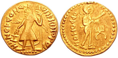
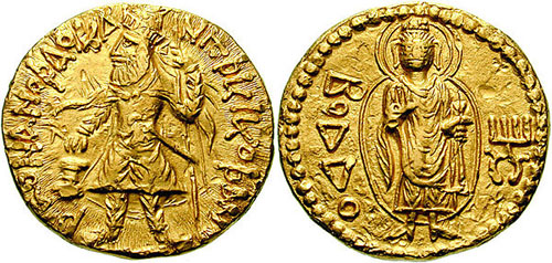
Gold coin of Kanishka. Greco-Bactrian legend: [x] Shaonanoshao Kanishki Koshano "King of Kings, Kanishka the Kushan". British Museum.
Reign: 2nd century (120-144)
Predecessor: Vima Kadphises
Successor: Huvishka
Born: c. 70, Kapisi
Died: 144 (aged 73-74)
Dynasty: Kushan dynasty
Religion: Buddhism
Kanishka I (Sanskrit: [x]; Greco-Bactrian: [x] Kanēške; Kharosthi: [x] Ka-ṇi-ṣka, Kaṇiṣka;[1] Brahmi: Kā-ṇi-ṣka), or Kanishka the Great, an emperor of the Kushan dynasty in the second century (c. 127–150 CE),[2] is famous for his military, political, and spiritual achievements. A descendant of Kujula Kadphises, founder of the Kushan empire, Kanishka came to rule an empire in Gandhara extending to Pataliputra on the Gangetic plain. The main capital of his empire was located at Puruṣapura (Peshawar) in Gandhara, with another major capital at Kapisa. Coins of Kanishka were found in Tripuri (jabalpur madhya pradesh)
His conquests and patronage of Buddhism played an important role in the development of the Silk Road, and in the transmission of Mahayana Buddhism from Gandhara across the Karakoram range to China. Around 127 CE, he replaced Greek by Bactrian as the official language of administration in the empire.[3]
Earlier scholars believed that Kanishka ascended the Kushan throne in 78 CE, and that this date was used as the beginning of the Saka calendar era. However, historians no longer regard this date as that of Kanishka's accession. Falk estimates that Kanishka came to the throne in 127 CE.[4]
Genealogy
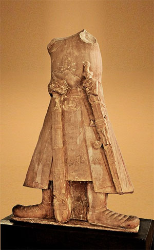
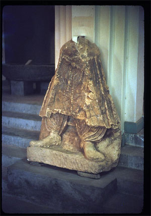
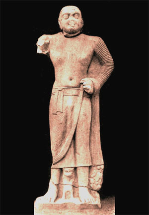
Mathura statue of Kanishka. The Kanishka statue in the Mathura Museum. There is a dedicatory inscription along the bottom of the coat.
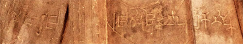
The inscription is in middle Brahmi script:
Mahārāja Rājadhirāja Devaputra Kāṇiṣka
"The Great King, King of Kings, Son of God, Kanishka".[5]
Mathura art, Mathura Museum
Kanishka was a Kushan of probable Yuezhi ethnicity.[6] His native language is unknown. The Rabatak inscription uses a Greek script, to write a language described as Arya (αρια) – most likely a form of Bactrian native to Ariana, which was an Eastern Iranian language of the Middle Iranian period.[7] However, this was likely adopted by the Kushans to facilitate communication with local subjects. It is not certain, what language the Kushan elite spoke among themselves.
Kanishka was the successor of Vima Kadphises, as demonstrated by an impressive genealogy of the Kushan kings, known as the Rabatak inscription.[8][9] The connection of Kanishka with other Kushan rulers is described in the Rabatak inscription as Kanishka makes the list of the kings who ruled up to his time: Kujula Kadphises as his great-grandfather, Vima Taktu as his grandfather, Vima Kadphises as his father, and himself Kanishka: "for King Kujula Kadphises (his) great grandfather, and for King Vima Taktu (his) grandfather, and for King Vima Kadphises (his) father, and *also for himself, King Kanishka".[10]
Conquests in South and Central Asia
Kanishka's empire was certainly vast. It extended from southern Uzbekistan and Tajikistan, north of the Amu Darya (Oxus) in the north west to Northern India, as far as Mathura in the south east (the Rabatak inscription even claims he held Pataliputra and Sri Champa), and his territory also included Kashmir, where there was a town Kanishkapur (modern day Kanispora), named after him not far from the Baramula Pass and which still contains the base of a large stupa.
Knowledge of his hold over Central Asia is less well established. The Book of the Later Han, Hou Hanshu, states that general Ban Chao fought battles near Khotan with a Kushan army of 70,000 men led by an otherwise unknown Kushan viceroy named Xie (Chinese:[x]) in 90 AD. Ban Chao claimed to be victorious, forcing the Kushans to retreat by use of a scorched-earth policy. The territories of Kashgar, Khotan and Yarkand were Chinese dependencies in the Tarim Basin, modern Xinjiang. Several coins of Kanishka have been found in the Tarim Basin.[11]
Controlling both the land (the Silk Road) and sea trade routes between South Asia and Rome seems to have been one of Kanishka's chief imperial goals.
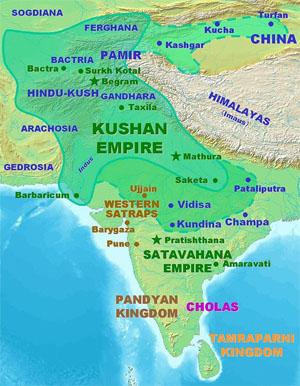
Kushan territories (full line) and maximum extent of Kushan dominions under Kanishka (dotted line), according to the Rabatak inscription.[12]
Probable statue of Kanishka, Surkh Kotal, 2nd century CE. Kabul Museum.[13]
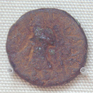
Bronze coin of Kanishka, found in Khotan, modern China.
Samatata coinage of king Vira Jadamarah, in imitation of the Kushan coinage of Kanishka I. Bengal, circa 2nd-3rd century CE.[14]
Kanishka's coins
Kanishka's coins portray images of Indian, Greek, Iranian and even Sumero-Elamite divinities, demonstrating the religious syncretism in his beliefs. Kanishka's coins from the beginning of his reign bear legends in Greek language and script and depict Greek divinities. Later coins bear legends in Bactrian, the Iranian language that the Kushans evidently spoke, and Greek divinities were replaced by corresponding Iranian ones. All of Kanishka's coins – even ones with a legend in the Bactrian language – were written in a modified Greek script that had one additional glyph ([x]) to represent /[x]/ (sh), as in the word 'Kushan' and 'Kanishka'.
On his coins, the king is typically depicted as a bearded man in a long coat and trousers gathered at the ankle, with flames emanating from his shoulders. He wears large rounded boots, and is armed with a long sword as well as a lance. He is frequently seen to be making a sacrifice on a small altar. The lower halfIranian and Indic of a lifesize limestone relief of Kanishka similarly attired, with a stiff embroidered surplice beneath his coat and spurs attached to his boots under the light gathered folds of his trousers, survived in the Kabul Museum until it was destroyed by the Taliban.[15]
Hellenistic phase
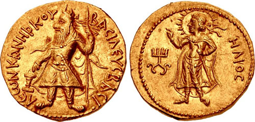
Gold coin of Kanishka I with Greek legend and Hellenistic divinity Helios. (c. 120 AD).
Obverse: Kanishka standing, clad in heavy Kushan coat and long boots, flames emanating from shoulders, holding a standard in his left hand, and making a sacrifice over an altar. Greek legend [x]"[coin] of Kanishka, king of kings".
Reverse: Standing Helios in Hellenistic style, forming a benediction gesture with the right hand. Legend in Greek script: [x] Helios. Kanishka monogram (tamgha) to the left.
A few coins at the beginning of his reign have a legend in the Greek language and script: [x], basileus basileon kaneshkou "[coin] of Kanishka, king of kings."
Greek deities, with Greek names are represented on these early coins:
• [x] (ēlios, Hēlios), [x] (ēphaēstos, Hephaistos), [x] (salēnē, Selene), [x] (anēmos, Anemos)
The inscriptions in Greek are full of spelling and syntactical errors.
Iranian / Indic phase
Following the transition to the Bactrian language on coins, Iranian and Indic divinities replace the Greek ones:
• [x] (ardoxsho, Ashi Vanghuhi)
• [x] (lrooaspo, Drvaspa)
• [x] (adsho, Atar)
• [x] (pharro, personified khwarenah)
• ΜΑΟ (mao, Mah)
• [x], (mithro, miiro, mioro, miuro, variants of Mithra)
• [x] (mozdaooano, "Mazda the victorious?")
• ΝΑΝΑ, ΝΑΝΑΙΑ, [x] (variants of pan-Asiatic Nana, Sogdian nny, in a Zoroastrian context Aredvi Sura Anahita)
• [x] (manaobago, Vohu Manah )
• [x] (oado, Vata)
• [x] (orlagno, Verethragna)
Only a few Buddhist divinities were used as well:
• [x] (boddo, Buddha),
• [x] (shakamano boddho, Shakyamuni Buddha)
• [x] (metrago boddo, the bodhisattava Maitreya)
Only a few Hindu divinities were used as well:
[x] (oesho, Shiva). A recent study indicate that oesho may be Avestan Vayu conflated with Shiva.[16][17]
Kanishka and Buddhism
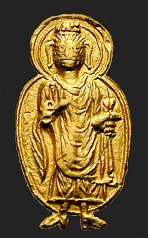
Gold coin of Kanishka I with a representation of the Buddha (c.120 AD).
Obv: Kanishka standing.., clad in heavy Kushan coat and long boots, flames emanating from shoulders, holding standard in his left hand, and making a sacrifice over an altar. Kushan-language legend in Greek script (with the addition of the Kushan [x] "sh" letter): [x] ("Shaonanoshao Kanishki Koshano"): "King of Kings, Kanishka the Kushan".
Rev: Standing Buddha in Hellenistic style, forming the gesture of "no fear" (abhaya mudra) with his right hand, and holding a pleat of his robe in his left hand. Legend in Greek script: [x] "Boddo", for the Buddha. Kanishka monogram (tamgha) to the right.
Kanishka's reputation in Buddhist tradition regarded with utmost importance as he not only believed in Buddhism but also encouraged its teachings as well. As a proof of it, he administered the 4th Buddhist Council in Kashmir as the head of the council. It was presided by Vasumitra and Ashwaghosha. Images of the Buddha based on 32 physical signs were made during his time.
He encouraged both Gandhara school of Greco-Buddhist Art and the Mathura school of Hindu art (an inescapable religious syncretism pervades Kushana rule). Kanishka personally seems to have embraced both Buddhism and the Persian attributes but he favored Buddhism more as it can be proven by his devotion to the Buddhist teachings and prayer styles depicted in various books related to kushan empire.
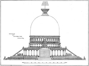
His greatest contribution to Buddhist architecture was the Kanishka stupa at Purushapura, modern day Peshawar. Archaeologists who rediscovered the base of it in 1908–1909 estimated that this stupa had a diameter of 286 feet (87 metres). Reports of Chinese pilgrims such as Xuanzang indicate that its height was 600 to 700 (Chinese) "feet" (= roughly 180–210 metres or 591–689 ft.) and was covered with jewels.[18] Certainly this immense multi-storied building ranks among the wonders of the ancient world.
Kanishka is said to have been particularly close to the Buddhist scholar Ashvaghosha, who became his religious advisor in his later years.
Buddhist coinage
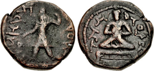
The Buddhist coins of Kanishka are comparatively rare (well under one percent of all known coins of Kanishka). Several show Kanishka on the obverse and the Buddha standing on the reverse. A few also show the Shakyamuni Buddha and Maitreya. Like all coins of Kanishka, the design is rather rough and proportions tend to be imprecise; the image of the Buddha is often slightly overdone, with oversize ears and feet spread apart in the same fashion as the Kushan king.
Three types of Kanishka's Buddhist coins are known:
Standing Buddha
Depiction of the Buddha enveloped in a mandala in Kanishka's coinage. The mandorla is normally considered as a late evolution in Gandhara art.[19]
Only six Kushan coins of the Buddha are known in gold (the sixth one is the centerpiece of an ancient piece of jewellery, consisting of a Kanishka Buddha coin decorated with a ring of heart-shaped ruby stones). All these coins were minted in gold under Kanishka I, and are in two different denominations: a dinar of about 8 gm, roughly similar to a Roman aureus, and a quarter dinar of about 2 gm. (about the size of an obol).
The Buddha is represented wearing the monastic robe, the antaravasaka, the uttarasanga, and the overcoat sanghati.
The ears are extremely large and long, a symbolic exaggeration possibly rendered necessary by the small size of the coins, but otherwise visible in some later Gandharan statues of the Buddha typically dated to the 3rd–4th century CE (illustration, left). He has an abundant topknot covering the usnisha, often highly stylised in a curly or often globular manner, also visible on later Buddha statues of Gandhara.
In general, the representation of the Buddha on these coins is already highly symbolic, and quite distinct from the more naturalistic and Hellenistic images seen in early Gandhara sculptures. On several designs a mustache is apparent. The palm of his right hand bears the Chakra mark, and his brow bear the urna. An aureola, formed by one, two or three lines, surrounds him.
The full gown worn by the Buddha on the coins, covering both shoulders, suggests a Gandharan model rather than a Mathuran one.
"Shakyamuni Buddha"
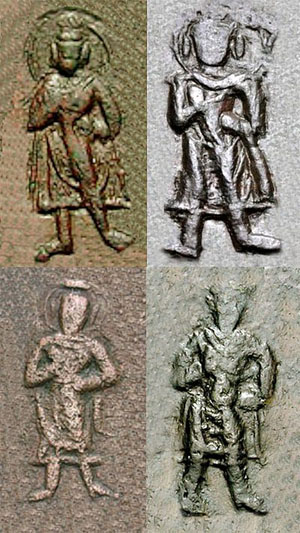
Depictions of the "Shakyamuni Buddha" (with legend [x] "Shakamano Boddo") in Kanishka's coinage.
The Shakyamuni Buddha (with the legend "Sakamano Boudo", i.e. Shakamuni Buddha, another name for the historic Buddha Siddharta Gautama), standing to front, with left hand on hip and forming the abhaya mudra with the right hand. All these coins are in copper only, and usually rather worn.
The gown of the Shakyamuni Buddha is quite light compared to that on the coins in the name of Buddha, clearly showing the outline of the body, in a nearly transparent way. These are probably the first two layers of monastic clothing the antaravasaka and the uttarasanga. Also, his gown is folded over the left arm (rather than being held in the left hand as above), a feature only otherwise known in the Bimaran casket and suggestive of a scarf-like uttariya. He has an abundant topknot covering the ushnisha, and a simple or double halo, sometimes radiating, surrounds his head.
"Maitreya Buddha"
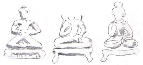
Depictions of "Maitreya" (with legend [x] "Metrago Boddo") in Kanishka's coinage.
The Bodhisattva Maitreya (with the legend "Metrago Boudo") cross-legged on a throne, holding a water pot, and also forming the Abhaya mudra. These coins are only known in copper and are quite worn out . On the clearest coins, Maitreya seems to be wearing the armbands of an Indian prince, a feature often seen on the statuary of Maitreya. The throne is decorated with small columns, suggesting that the coin representation of Maitreya was directly copied from pre-existing statuary with such well-known features.
The qualification of "Buddha" for Maitreya is inaccurate, as he is instead a Bodhisattva (he is the Buddha of the future).
The iconography of these three types is very different from that of the other deities depicted in Kanishka's coinage. Whether Kanishka's deities are all shown from the side, the Buddhas only are shown frontally, indicating that they were copied from contemporary frontal representations of the standing and seated Buddhas in statuary.[20] Both representations of the Buddha and Shakyamuni have both shoulders covered by their monastic gown, indicating that the statues used as models were from the Gandhara school of art, rather than Mathura.
Buddhist statuary under Kanishka
See also: Kushan art
Several Buddhist statues are directly connected to the reign of Kanishka, such as several Bodhisattva statues from the Art of Mathura, while a few other from Gandhara are inscribed with a date in an era which is now thought to be the Yavana era, starting in 186 to 175 BCE.[21]
Dated statuary under Kanishka
Kosambi Bodhisattva, inscribed "Year 2 of Kanishka".[22]
Bala Bodhisattva, Sarnath, inscribed "Year 3 of Kanishka".[23]
"Kimbell seated Buddha", with inscription "year 4 of Kanishka" (131 CE).[24][25] Another similar statue has "Year 32 of Kanishka".[26]
Gandhara Buddhist Triad from Sahr-i-Bahlol, circa 132 CE, similar to the dated Brussels Buddha.[27] Peshawar Museum.[28][29]
Image of a Nāga between two Nāgīs, inscribed in "the year 8 of Emperor Kanishka". 135 CE.[30][31][32]
Buddha from Loriyan Tangai with inscription mentionning the "year 318", thought to be 143 CE.[21]
A Buddha from Loriyan Tangai from the same period.[21]
Kanishka stupa
Main articles: Kanishka stupa and Kanishka casket
Kanishka casket
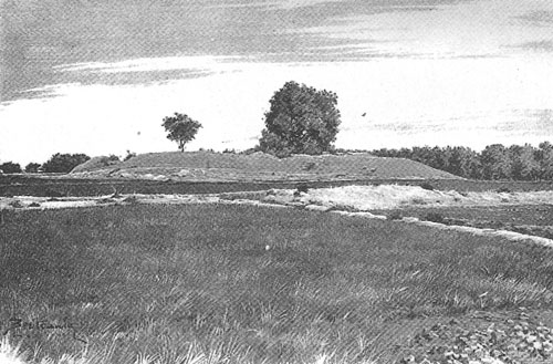
Remnants of the Kanishka stupa.
Kanishka, surrounded by the Iranian Sun-God and Moon-God (detail)
Relics from Kanishka's stupa in Peshawar, sent by the British to Mandalay, Burma in 1910.
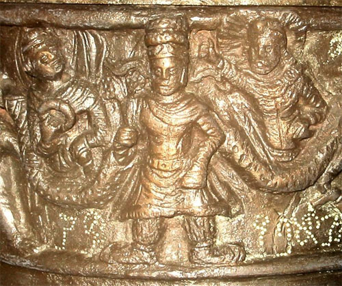
The "Kanishka casket", dated to 127 CE, with the Buddha surrounded by Brahma and Indra, and Kanishka standing at the center of the lower part, British Museum.
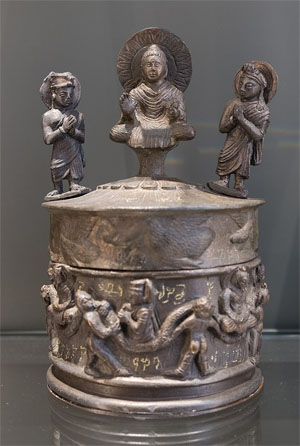
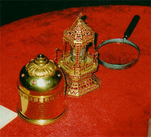
The "Kanishka casket" or "Kanishka reliquary", dated to the first year of Kanishka's reign in 127 CE, was discovered in a deposit chamber under Kanishka stupa, during the archaeological excavations in 1908–1909 in Shah-Ji-Ki-Dheri, just outside the present-day Ganj Gate of the old city of Peshawar.[33][34] It is today at the Peshawar Museum, and a copy is in the British Museum. It is said to have contained three bone fragments of the Buddha, which are now housed in Mandalay, Burma.
The casket is dedicated in Kharoshthi. The inscription reads:
The text is signed by the maker, a Greek artist named Agesilas, who oversaw work at Kanishka's stupas (caitya), confirming the direct involvement of Greeks with Buddhist realisations at such a late date: "The servant Agisalaos, the superintendent of works at the vihara of Kanishka in the monastery of Mahasena" ("dasa agisala nava-karmi ana*kaniskasa vihara mahasenasa sangharame").
The lid of the casket shows the Buddha on a lotus pedestal, and worshipped by Brahma and Indra. The edge of the lid is decorated by a frieze of flying geese. The body of the casket represents a Kushan monarch, probably Kanishka in person, with the Iranian sun and moon gods on his side. On the sides are two images of a seated Buddha, worshiped by royal figures, can be assumed as Kanishka. A garland, supported by cherubs goes around the scene in typical Hellenistic style.
The attribution of the casket to Kanishka has been recently disputed, essentially on stylistic ground (for example the ruler shown on the casket is not bearded, to the contrary of Kanishka). Instead, the casket is often attributed to Kanishka's successor Huvishka.
Kanishka in Buddhist tradition
Kanishka inaugurates Mahayana Buddhism
In Buddhist tradition, Kanishka is often described as an aggressive, hot tempered, rigid, strict, and a bit harsh kind of King before he got converted to Buddhism of which he was very fond, and after his conversion to Buddhism, he became an openhearted, benevolent, and faithful ruler. As in the Sri-dharma-pitaka-nidana sutra:
"At this time the King of Ngan-si (Pahlava) was very aggressive and of a violent nature....There was a bhikshu (monk) arhat who seeing the harsh deeds done by the king wished to make him repent. So by his supernatural force he caused the king to see the torments of hell. The king was terrified and repented and cried terribly and hence dissolved all his negatives within him and got self realised for the first time in life ." Śri-dharma-piṭaka-nidāna sūtra[35]
Additionally, the arrival of Kanishka was reportedly foretold or was predicted by the Buddha, as well as the construction of his stupa:
Coin of Kanishka with the Bodhisattva Maitreya "Metrago Boudo".
The Ahin Posh stupa was dedicated in the 2nd century CE and contained coins of Kaniska
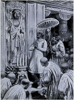
The same story is repeated in a Khotanese scroll found at Dunhuang, which first described how Kanishka would arrive 400 years after the death of the Buddha. The account also describes how Kanishka came to raise his stupa:
Chinese pilgrims to India, such as Xuanzang, who travelled there around 630 CE also relays the story:
King Kanishka because of his deeds was highly respected, regarded, honored by all the people he ruled and governed and was regarded the greatest king who ever lived because of his kindness, humbleness and sense of equality and self-righteousness among all aspects. Thus such great deeds and character of the king Kanishka made his name immortal and thus he was regarded "THE KING OF KINGS"[38]
Transmission of Buddhism to China
Main article: Silk Road transmission of Buddhism
Buddhist monks from the region of Gandhara played a key role in the development and the transmission of Buddhist ideas in the direction of northern Asia from the middle of the 2nd century CE. The Kushan monk, Lokaksema (c. 178 CE), became the first translator of Mahayana Buddhist scriptures into Chinese and established a translation bureau at the Chinese capital Loyang. Central Asian and East Asian Buddhist monks appear to have maintained strong exchanges for the following centuries.
Kanishka was probably succeeded by Huvishka. How and when this came about is still uncertain. It is a fact that there was only one king named Kanishka in the whole Kushan legacy. The inscription on The Sacred Rock of Hunza also shows the signs of Kanishka.
See also
• Menander I
• Greco-Buddhism
Footnotes
1. B.N. Mukhjerjee, Shāh-jī-kī-ḍherī Casket Inscription, The British Museum Quarterly, Vol. 28, No. 1/2 (Summer, 1964), pp. 39-46
2. Bracey, Robert (2017). "The Date of Kanishka since 1960 (Indian Historical Review, 2017, 44(1), 1-41)". Indian Historical Review. 44: 1–41.
3. The Kushans at first retained the Greek language for administrative purposes but soon began to use Bactrian. The Bactrian Rabatak inscription (discovered in 1993 and deciphered in 2000) records that the Kushan king Kanishka the Great (c. 127 AD), discarded Greek (Ionian) as the language of administration and adopted Bactrian ("Arya language"), from Falk (2001): "The yuga of Sphujiddhvaja and the era of the Kuṣâṇas." Harry Falk. Silk Road Art and Archaeology VII, p. 133.
4. Falk (2001), pp. 121–136. Falk (2004), pp. 167–176.
5. Puri, Baij Nath (1965). India under the Kushāṇas. Bharatiya Vidya Bhavan.
6. Findeisen, Raoul David; Isay, Gad C.; Katz-Goehr, Amira (2009). At Home in Many Worlds: Reading, Writing and Translating from Chinese and Jewish Cultures : Essays in Honour of Irene Eber. Otto Harrassowitz Verlag. p. 138. ISBN 9783447061353.
7. Gnoli (2002), pp. 84–90.
8. Sims-Williams and Cribb (1995/6), pp.75–142.
9. Sims-Williams (1998), pp. 79–83.
10. Sims-Williams and Cribb (1995/6), p. 80.
11. Hill (2009), p. 11.
12. "The Rabatak inscription claims that in the year 1 Kanishka I's authority was proclaimed in India, in all the satrapies and in different cities like Koonadeano (Kundina), Ozeno (Ujjain), Kozambo (Kausambi), Zagedo (Saketa), Palabotro (Pataliputra) and Ziri-Tambo (Janjgir-Champa). These cities lay to the east and south of Mathura, up to which locality Wima had already carried his victorious arm. Therefore they must have been captured or subdued by Kanishka I himself." Ancient Indian Inscriptions, S. R. Goyal, p. 93. See also the analysis of Sims-Williams and J. Cribb, who had a central role in the decipherment: "A new Bactrian inscription of Kanishka the Great", in Silk Road Art and Archaeology No. 4, 1995–1996. Also see, Mukherjee, B. N. "The Great Kushanan Testament", Indian Museum Bulletin.
13. Lo Muzio, Ciro (2012). "Remarks on the Paintings from the Buddhist Monastery of Fayaz Tepe (Southern Uzbekistan)". Bulletin of the Asia Institute. 22: 189–206.
14. "Samatata coin". British Museum.
15. Wood (2002), illus. p. 39.
16. Sims-Williams (online) Encyclopedia Iranica.
17. H. Humbach, 1975, p.402-408. K. Tanabe, 1997, p.277, M. Carter, 1995, p. 152. J. Cribb, 1997, p. 40. References cited in De l'Indus à l'Oxus.
18. Dobbins (1971).
19. "In Gandhara the appearance of a halo surrounding an entire figure occurs only in the latest phases of artistic production, in the fifth and sixth centuries. By this time in Afghanistan the halo/mandorla had become quite common and is the format that took hold at Central Asian Buddhist sites." in "Metropolitan Museum of Art". http://www.metmuseum.org.
20. The Crossroads of Asia, p. 201. (Full[citation needed] here.)
21. Rhi, Juhyung (2017). Problems of Chronology in Gandharan. Positionning Gandharan Buddhas in Chronology (PDF). Oxford: Archaeopress Archaeology. pp. 35–51.
22. Early History of Kausambi p.xxi
23. Epigraphia Indica 8 p.179
24. Seated Buddha with inscription starting with [x] Maharajasya Kanishkasya Sam 4 "Year 4 of the Great King Kanishka" in "Seated Buddha with Two Attendants". http://www.kimbellart.org. Kimbell Art Museum.
25. "The Buddhist Triad, from Haryana or Mathura, Year 4 of Kaniska (ad 82). Kimbell Art Museum, Fort Worth." in Museum (Singapore), Asian Civilisations; Krishnan, Gauri Parimoo (2007). The Divine Within: Art & Living Culture of India & South Asia. World Scientific Pub. p. 113. ISBN 9789810567057.
26. Behrendt, Kurt A. (2007). The Art of Gandhara in the Metropolitan Museum of Art. Metropolitan Museum of Art. p. 48, Fig. 18. ISBN 9781588392244.
27. FUSSMAN, Gérard (1974). "Documents Epigraphiques Kouchans". Bulletin de l'École française d'Extrême-Orient. 61: 54–57. doi:10.3406/befeo.1974.5193. ISSN 0336-1519. JSTOR 43732476.
28. Rhi, Juhyung. Identifying Several Visual Types of Gandharan Buddha Images. Archives of Asian Art 58 (2008). pp. 53–56.
29. The Classical Art Research Centre, University of Oxford (2018). Problems of Chronology in Gandhāran Art: Proceedings of the First International Workshop of the Gandhāra Connections Project, University of Oxford, 23rd-24th March, 2017. Archaeopress. p. 45, notes 28, 29.
30. Sircar, Dineschandra (1971). Studies in the Religious Life of Ancient and Medieval India. Motilal Banarsidass Publ. ISBN 978-81-208-2790-5.
31. Sastri, H. krishna (1923). Epigraphia Indica Vol-17. pp. 11–15.
32. Luders, Heinrich (1961). Mathura Inscriptions. pp. 148–149.
33. Hargreaves (1910–11), pp. 25–32.
34. Spooner, (1908–9), pp. 38–59.
35. Kumar (1973), p. 95.
36. Kumar (1973), p. 91.
37. Kumar (1973). p. 89.
38. Xuanzang, quoted in: Kumar (1973), p. 93.
References
• Bopearachchi, Osmund (2003). De l'Indus à l'Oxus, Archéologie de l'Asie Centrale (in French). Lattes: Association imago-musée de Lattes. ISBN 978-2-9516679-2-1.
• Chavannes, Édouard. (1906) "Trois Généraux Chinois de la dynastie des Han Orientaux. Pan Tch'ao (32–102 p. C.); – son fils Pan Yong; – Leang K'in (112 p. C.). Chapitre LXXVII du Heou Han chou." T'oung pao 7, (1906) p. 232 and note 3.
• Dobbins, K. Walton. (1971). The Stūpa and Vihāra of Kanishka I. The Asiatic Society of Bengal Monograph Series, Vol. XVIII. Calcutta.
• Falk, Harry (2001): "The yuga of Sphujiddhvaja and the era of the Kuṣâṇas." In: Silk Road Art and Archaeology VII, pp. 121–136.
• Falk, Harry (2004): "The Kaniṣka era in Gupta records." In: Silk Road Art and Archaeology X (2004), pp. 167–176.
• Foucher, M. A. 1901. "Notes sur la geographie ancienne du Gandhâra (commentaire à un chapitre de Hiuen-Tsang)." BEFEO No. 4, Oct. 1901, pp. 322–369.
• Gnoli, Gherardo (2002). "The "Aryan" Language." JSAI 26 (2002).
• Hargreaves, H. (1910–11): "Excavations at Shāh-jī-kī Dhērī"; Archaeological Survey of India, 1910–11.
• Hill, John E. (2009) Through the Jade Gate to Rome: A Study of the Silk Routes during the Later Han Dynasty, 1st to 2nd centuries CE. BookSurge, Charleston, South Carolina. ISBN 978-1-4392-2134-1.
• Kulke, Hermann; Rothermund, Dietmar (1998). A history of India. London; New York: Routledge. ISBN 978-0-415-15481-9.
• Kumar, Baldev. 1973. The Early Kuṣāṇas. New Delhi, Sterling Publishers.
• Sims-Williams, Nicholas and Joe Cribb (1995/6): "A New Bactrian Inscription of Kanishka the Great." Silk Road Art and Archaeology 4 (1996), pp. 75–142.
• Sims-Williams, Nicholas (1998): "Further notes on the Bactrian inscription of Rabatak, with an Appendix on the names of Kujula Kadphises and Vima Taktu in Chinese." Proceedings of the Third European Conference of Iranian Studies Part 1: Old and Middle Iranian Studies. Edited by Nicholas Sims-Williams. Wiesbaden. 1998, pp. 79–93.
• Sims-Williams, Nicholas. Sims-Williams, Nicolas. "Bactrian Language". Encyclopaedia Iranica. 3. London: Routledge & Kegan Paul. Accessed: 20/12/2010
• Spooner, D. B. (1908–9): "Excavations at Shāh-jī-kī Dhērī."; Archaeological Survey of India, 1908-9.
• Wood, Frances (2003). The Silk Road: Two Thousand Years in the Heart of Asia. University of California Press. Hbk (2003), ISBN 978-0-520-23786-5; pbk. (2004) ISBN 978-0-520-24340-8
External links
• Media related to Kanishka I at Wikimedia Commons
• A rough guide to Kushana history.
• Online Catalogue of Kanishka's Coins
• Coins of Kanishka
• Controversy regarding the beginning of the Kanishka Era.
• Kanishka Buddhist coins
• Photograph of the Kanishka casket
1. From the dated inscription on the Rukhana reliquary
2. Richard Salomon (July–September 1996). "An Inscribed Silver Buddhist Reliquary of the Time of King Kharaosta and Prince Indravarman". Journal of the American Oriental Society. 116 (3): 418–452 [442]. JSTOR 605147.
3. Richard Salomon (1995) [Published online: 9 Aug 2010]. "A Kharosthī Reliquary Inscription of the Time of the Apraca Prince Visnuvarma". South Asian Studies. 11 (1): 27–32. doi:10.1080/02666030.1995.9628492.
4. Jongeward, David; Cribb, Joe (2014). Kushan, Kushano-Sasanian, and Kidarite Coins A Catalogue of Coins From the American Numismatic Society by David Jongeward and Joe Cribb with Peter Donovan. p. 4.
by Wikipedia
Accessed: 9/3/21
Kanishka I
Kushan emperor
Gold coin of Kanishka. Greco-Bactrian legend: [x] Shaonanoshao Kanishki Koshano "King of Kings, Kanishka the Kushan". British Museum.
Reign: 2nd century (120-144)
Predecessor: Vima Kadphises
Successor: Huvishka
Born: c. 70, Kapisi
Died: 144 (aged 73-74)
Dynasty: Kushan dynasty
Religion: Buddhism
Kanishka I (Sanskrit: [x]; Greco-Bactrian: [x] Kanēške; Kharosthi: [x] Ka-ṇi-ṣka, Kaṇiṣka;[1] Brahmi: Kā-ṇi-ṣka), or Kanishka the Great, an emperor of the Kushan dynasty in the second century (c. 127–150 CE),[2] is famous for his military, political, and spiritual achievements. A descendant of Kujula Kadphises, founder of the Kushan empire, Kanishka came to rule an empire in Gandhara extending to Pataliputra on the Gangetic plain. The main capital of his empire was located at Puruṣapura (Peshawar) in Gandhara, with another major capital at Kapisa. Coins of Kanishka were found in Tripuri (jabalpur madhya pradesh)
His conquests and patronage of Buddhism played an important role in the development of the Silk Road, and in the transmission of Mahayana Buddhism from Gandhara across the Karakoram range to China. Around 127 CE, he replaced Greek by Bactrian as the official language of administration in the empire.[3]
Earlier scholars believed that Kanishka ascended the Kushan throne in 78 CE, and that this date was used as the beginning of the Saka calendar era. However, historians no longer regard this date as that of Kanishka's accession. Falk estimates that Kanishka came to the throne in 127 CE.[4]
Genealogy
Mathura statue of Kanishka. The Kanishka statue in the Mathura Museum. There is a dedicatory inscription along the bottom of the coat.
The inscription is in middle Brahmi script:
Mahārāja Rājadhirāja Devaputra Kāṇiṣka
"The Great King, King of Kings, Son of God, Kanishka".[5]
Mathura art, Mathura Museum
Kanishka was a Kushan of probable Yuezhi ethnicity.[6] His native language is unknown. The Rabatak inscription uses a Greek script, to write a language described as Arya (αρια) – most likely a form of Bactrian native to Ariana, which was an Eastern Iranian language of the Middle Iranian period.[7] However, this was likely adopted by the Kushans to facilitate communication with local subjects. It is not certain, what language the Kushan elite spoke among themselves.
Kanishka was the successor of Vima Kadphises, as demonstrated by an impressive genealogy of the Kushan kings, known as the Rabatak inscription.[8][9] The connection of Kanishka with other Kushan rulers is described in the Rabatak inscription as Kanishka makes the list of the kings who ruled up to his time: Kujula Kadphises as his great-grandfather, Vima Taktu as his grandfather, Vima Kadphises as his father, and himself Kanishka: "for King Kujula Kadphises (his) great grandfather, and for King Vima Taktu (his) grandfather, and for King Vima Kadphises (his) father, and *also for himself, King Kanishka".[10]
Conquests in South and Central Asia
Kanishka's empire was certainly vast. It extended from southern Uzbekistan and Tajikistan, north of the Amu Darya (Oxus) in the north west to Northern India, as far as Mathura in the south east (the Rabatak inscription even claims he held Pataliputra and Sri Champa), and his territory also included Kashmir, where there was a town Kanishkapur (modern day Kanispora), named after him not far from the Baramula Pass and which still contains the base of a large stupa.
Knowledge of his hold over Central Asia is less well established. The Book of the Later Han, Hou Hanshu, states that general Ban Chao fought battles near Khotan with a Kushan army of 70,000 men led by an otherwise unknown Kushan viceroy named Xie (Chinese:[x]) in 90 AD. Ban Chao claimed to be victorious, forcing the Kushans to retreat by use of a scorched-earth policy. The territories of Kashgar, Khotan and Yarkand were Chinese dependencies in the Tarim Basin, modern Xinjiang. Several coins of Kanishka have been found in the Tarim Basin.[11]
Controlling both the land (the Silk Road) and sea trade routes between South Asia and Rome seems to have been one of Kanishka's chief imperial goals.
Kushan territories (full line) and maximum extent of Kushan dominions under Kanishka (dotted line), according to the Rabatak inscription.[12]
Probable statue of Kanishka, Surkh Kotal, 2nd century CE. Kabul Museum.[13]
Bronze coin of Kanishka, found in Khotan, modern China.
Samatata coinage of king Vira Jadamarah, in imitation of the Kushan coinage of Kanishka I. Bengal, circa 2nd-3rd century CE.[14]
Kanishka's coins
Kanishka's coins portray images of Indian, Greek, Iranian and even Sumero-Elamite divinities, demonstrating the religious syncretism in his beliefs. Kanishka's coins from the beginning of his reign bear legends in Greek language and script and depict Greek divinities. Later coins bear legends in Bactrian, the Iranian language that the Kushans evidently spoke, and Greek divinities were replaced by corresponding Iranian ones. All of Kanishka's coins – even ones with a legend in the Bactrian language – were written in a modified Greek script that had one additional glyph ([x]) to represent /[x]/ (sh), as in the word 'Kushan' and 'Kanishka'.
On his coins, the king is typically depicted as a bearded man in a long coat and trousers gathered at the ankle, with flames emanating from his shoulders. He wears large rounded boots, and is armed with a long sword as well as a lance. He is frequently seen to be making a sacrifice on a small altar. The lower halfIranian and Indic of a lifesize limestone relief of Kanishka similarly attired, with a stiff embroidered surplice beneath his coat and spurs attached to his boots under the light gathered folds of his trousers, survived in the Kabul Museum until it was destroyed by the Taliban.[15]
Hellenistic phase
Gold coin of Kanishka I with Greek legend and Hellenistic divinity Helios. (c. 120 AD).
Obverse: Kanishka standing, clad in heavy Kushan coat and long boots, flames emanating from shoulders, holding a standard in his left hand, and making a sacrifice over an altar. Greek legend [x]"[coin] of Kanishka, king of kings".
Reverse: Standing Helios in Hellenistic style, forming a benediction gesture with the right hand. Legend in Greek script: [x] Helios. Kanishka monogram (tamgha) to the left.
A few coins at the beginning of his reign have a legend in the Greek language and script: [x], basileus basileon kaneshkou "[coin] of Kanishka, king of kings."
Greek deities, with Greek names are represented on these early coins:
• [x] (ēlios, Hēlios), [x] (ēphaēstos, Hephaistos), [x] (salēnē, Selene), [x] (anēmos, Anemos)
The inscriptions in Greek are full of spelling and syntactical errors.
Iranian / Indic phase
Following the transition to the Bactrian language on coins, Iranian and Indic divinities replace the Greek ones:
• [x] (ardoxsho, Ashi Vanghuhi)
• [x] (lrooaspo, Drvaspa)
• [x] (adsho, Atar)
• [x] (pharro, personified khwarenah)
• ΜΑΟ (mao, Mah)
• [x], (mithro, miiro, mioro, miuro, variants of Mithra)
• [x] (mozdaooano, "Mazda the victorious?")
• ΝΑΝΑ, ΝΑΝΑΙΑ, [x] (variants of pan-Asiatic Nana, Sogdian nny, in a Zoroastrian context Aredvi Sura Anahita)
• [x] (manaobago, Vohu Manah )
• [x] (oado, Vata)
• [x] (orlagno, Verethragna)
Only a few Buddhist divinities were used as well:
• [x] (boddo, Buddha),
• [x] (shakamano boddho, Shakyamuni Buddha)
• [x] (metrago boddo, the bodhisattava Maitreya)
Only a few Hindu divinities were used as well:
[x] (oesho, Shiva). A recent study indicate that oesho may be Avestan Vayu conflated with Shiva.[16][17]
Kanishka and Buddhism
Gold coin of Kanishka I with a representation of the Buddha (c.120 AD).
Obv: Kanishka standing.., clad in heavy Kushan coat and long boots, flames emanating from shoulders, holding standard in his left hand, and making a sacrifice over an altar. Kushan-language legend in Greek script (with the addition of the Kushan [x] "sh" letter): [x] ("Shaonanoshao Kanishki Koshano"): "King of Kings, Kanishka the Kushan".
Rev: Standing Buddha in Hellenistic style, forming the gesture of "no fear" (abhaya mudra) with his right hand, and holding a pleat of his robe in his left hand. Legend in Greek script: [x] "Boddo", for the Buddha. Kanishka monogram (tamgha) to the right.
Kanishka's reputation in Buddhist tradition regarded with utmost importance as he not only believed in Buddhism but also encouraged its teachings as well. As a proof of it, he administered the 4th Buddhist Council in Kashmir as the head of the council. It was presided by Vasumitra and Ashwaghosha. Images of the Buddha based on 32 physical signs were made during his time.
He encouraged both Gandhara school of Greco-Buddhist Art and the Mathura school of Hindu art (an inescapable religious syncretism pervades Kushana rule). Kanishka personally seems to have embraced both Buddhism and the Persian attributes but he favored Buddhism more as it can be proven by his devotion to the Buddhist teachings and prayer styles depicted in various books related to kushan empire.
His greatest contribution to Buddhist architecture was the Kanishka stupa at Purushapura, modern day Peshawar. Archaeologists who rediscovered the base of it in 1908–1909 estimated that this stupa had a diameter of 286 feet (87 metres). Reports of Chinese pilgrims such as Xuanzang indicate that its height was 600 to 700 (Chinese) "feet" (= roughly 180–210 metres or 591–689 ft.) and was covered with jewels.[18] Certainly this immense multi-storied building ranks among the wonders of the ancient world.
Kanishka is said to have been particularly close to the Buddhist scholar Ashvaghosha, who became his religious advisor in his later years.
Buddhist coinage
The Buddhist coins of Kanishka are comparatively rare (well under one percent of all known coins of Kanishka). Several show Kanishka on the obverse and the Buddha standing on the reverse. A few also show the Shakyamuni Buddha and Maitreya. Like all coins of Kanishka, the design is rather rough and proportions tend to be imprecise; the image of the Buddha is often slightly overdone, with oversize ears and feet spread apart in the same fashion as the Kushan king.
Three types of Kanishka's Buddhist coins are known:
Standing Buddha
Depiction of the Buddha enveloped in a mandala in Kanishka's coinage. The mandorla is normally considered as a late evolution in Gandhara art.[19]
Only six Kushan coins of the Buddha are known in gold (the sixth one is the centerpiece of an ancient piece of jewellery, consisting of a Kanishka Buddha coin decorated with a ring of heart-shaped ruby stones). All these coins were minted in gold under Kanishka I, and are in two different denominations: a dinar of about 8 gm, roughly similar to a Roman aureus, and a quarter dinar of about 2 gm. (about the size of an obol).
The Buddha is represented wearing the monastic robe, the antaravasaka, the uttarasanga, and the overcoat sanghati.
The ears are extremely large and long, a symbolic exaggeration possibly rendered necessary by the small size of the coins, but otherwise visible in some later Gandharan statues of the Buddha typically dated to the 3rd–4th century CE (illustration, left). He has an abundant topknot covering the usnisha, often highly stylised in a curly or often globular manner, also visible on later Buddha statues of Gandhara.
In general, the representation of the Buddha on these coins is already highly symbolic, and quite distinct from the more naturalistic and Hellenistic images seen in early Gandhara sculptures. On several designs a mustache is apparent. The palm of his right hand bears the Chakra mark, and his brow bear the urna. An aureola, formed by one, two or three lines, surrounds him.
The full gown worn by the Buddha on the coins, covering both shoulders, suggests a Gandharan model rather than a Mathuran one.
"Shakyamuni Buddha"
Depictions of the "Shakyamuni Buddha" (with legend [x] "Shakamano Boddo") in Kanishka's coinage.
The Shakyamuni Buddha (with the legend "Sakamano Boudo", i.e. Shakamuni Buddha, another name for the historic Buddha Siddharta Gautama), standing to front, with left hand on hip and forming the abhaya mudra with the right hand. All these coins are in copper only, and usually rather worn.
The gown of the Shakyamuni Buddha is quite light compared to that on the coins in the name of Buddha, clearly showing the outline of the body, in a nearly transparent way. These are probably the first two layers of monastic clothing the antaravasaka and the uttarasanga. Also, his gown is folded over the left arm (rather than being held in the left hand as above), a feature only otherwise known in the Bimaran casket and suggestive of a scarf-like uttariya. He has an abundant topknot covering the ushnisha, and a simple or double halo, sometimes radiating, surrounds his head.
"Maitreya Buddha"
Depictions of "Maitreya" (with legend [x] "Metrago Boddo") in Kanishka's coinage.
The Bodhisattva Maitreya (with the legend "Metrago Boudo") cross-legged on a throne, holding a water pot, and also forming the Abhaya mudra. These coins are only known in copper and are quite worn out . On the clearest coins, Maitreya seems to be wearing the armbands of an Indian prince, a feature often seen on the statuary of Maitreya. The throne is decorated with small columns, suggesting that the coin representation of Maitreya was directly copied from pre-existing statuary with such well-known features.
The qualification of "Buddha" for Maitreya is inaccurate, as he is instead a Bodhisattva (he is the Buddha of the future).
The iconography of these three types is very different from that of the other deities depicted in Kanishka's coinage. Whether Kanishka's deities are all shown from the side, the Buddhas only are shown frontally, indicating that they were copied from contemporary frontal representations of the standing and seated Buddhas in statuary.[20] Both representations of the Buddha and Shakyamuni have both shoulders covered by their monastic gown, indicating that the statues used as models were from the Gandhara school of art, rather than Mathura.
Buddhist statuary under Kanishka
See also: Kushan art
Several Buddhist statues are directly connected to the reign of Kanishka, such as several Bodhisattva statues from the Art of Mathura, while a few other from Gandhara are inscribed with a date in an era which is now thought to be the Yavana era, starting in 186 to 175 BCE.[21]
Dated statuary under Kanishka
Kosambi Bodhisattva, inscribed "Year 2 of Kanishka".[22]
Bala Bodhisattva, Sarnath, inscribed "Year 3 of Kanishka".[23]
"Kimbell seated Buddha", with inscription "year 4 of Kanishka" (131 CE).[24][25] Another similar statue has "Year 32 of Kanishka".[26]
Gandhara Buddhist Triad from Sahr-i-Bahlol, circa 132 CE, similar to the dated Brussels Buddha.[27] Peshawar Museum.[28][29]
Image of a Nāga between two Nāgīs, inscribed in "the year 8 of Emperor Kanishka". 135 CE.[30][31][32]
Buddha from Loriyan Tangai with inscription mentionning the "year 318", thought to be 143 CE.[21]
A Buddha from Loriyan Tangai from the same period.[21]
Kanishka stupa
Main articles: Kanishka stupa and Kanishka casket
Kanishka casket
Remnants of the Kanishka stupa.
Kanishka, surrounded by the Iranian Sun-God and Moon-God (detail)
Relics from Kanishka's stupa in Peshawar, sent by the British to Mandalay, Burma in 1910.
The "Kanishka casket", dated to 127 CE, with the Buddha surrounded by Brahma and Indra, and Kanishka standing at the center of the lower part, British Museum.
The "Kanishka casket" or "Kanishka reliquary", dated to the first year of Kanishka's reign in 127 CE, was discovered in a deposit chamber under Kanishka stupa, during the archaeological excavations in 1908–1909 in Shah-Ji-Ki-Dheri, just outside the present-day Ganj Gate of the old city of Peshawar.[33][34] It is today at the Peshawar Museum, and a copy is in the British Museum. It is said to have contained three bone fragments of the Buddha, which are now housed in Mandalay, Burma.
The casket is dedicated in Kharoshthi. The inscription reads:
"(*mahara)jasa kanishkasa kanishka-pure nagare aya gadha-karae deya-dharme sarva-satvana hita-suhartha bhavatu mahasenasa sagharaki dasa agisala nava-karmi ana*kanishkasa vihare mahasenasa sangharame"
The text is signed by the maker, a Greek artist named Agesilas, who oversaw work at Kanishka's stupas (caitya), confirming the direct involvement of Greeks with Buddhist realisations at such a late date: "The servant Agisalaos, the superintendent of works at the vihara of Kanishka in the monastery of Mahasena" ("dasa agisala nava-karmi ana*kaniskasa vihara mahasenasa sangharame").
The lid of the casket shows the Buddha on a lotus pedestal, and worshipped by Brahma and Indra. The edge of the lid is decorated by a frieze of flying geese. The body of the casket represents a Kushan monarch, probably Kanishka in person, with the Iranian sun and moon gods on his side. On the sides are two images of a seated Buddha, worshiped by royal figures, can be assumed as Kanishka. A garland, supported by cherubs goes around the scene in typical Hellenistic style.
The attribution of the casket to Kanishka has been recently disputed, essentially on stylistic ground (for example the ruler shown on the casket is not bearded, to the contrary of Kanishka). Instead, the casket is often attributed to Kanishka's successor Huvishka.
Kanishka in Buddhist tradition
Kanishka inaugurates Mahayana Buddhism
In Buddhist tradition, Kanishka is often described as an aggressive, hot tempered, rigid, strict, and a bit harsh kind of King before he got converted to Buddhism of which he was very fond, and after his conversion to Buddhism, he became an openhearted, benevolent, and faithful ruler. As in the Sri-dharma-pitaka-nidana sutra:
"At this time the King of Ngan-si (Pahlava) was very aggressive and of a violent nature....There was a bhikshu (monk) arhat who seeing the harsh deeds done by the king wished to make him repent. So by his supernatural force he caused the king to see the torments of hell. The king was terrified and repented and cried terribly and hence dissolved all his negatives within him and got self realised for the first time in life ." Śri-dharma-piṭaka-nidāna sūtra[35]
Additionally, the arrival of Kanishka was reportedly foretold or was predicted by the Buddha, as well as the construction of his stupa:
". . . the Buddha, pointing to a small boy making a mud tope....[said] that on that spot Kaṇiṣka would erect a tope by his name." Vinaya sutra[36]
Coin of Kanishka with the Bodhisattva Maitreya "Metrago Boudo".
The Ahin Posh stupa was dedicated in the 2nd century CE and contained coins of Kaniska
The same story is repeated in a Khotanese scroll found at Dunhuang, which first described how Kanishka would arrive 400 years after the death of the Buddha. The account also describes how Kanishka came to raise his stupa:
"A desire thus arose in [Kanishka to build a vast stupa]....at that time the four world-regents learnt the mind of the king. So for his sake they took the form of young boys....[and] began a stūpa of mud....the boys said to [Kanishka] 'We are making the Kaṇiṣka-stūpa.'....At that time the boys changed their form....[and] said to him, 'Great king, by you according to the Buddha's prophecy is a Saṅghārāma to be built wholly (?) with a large stūpa and hither relics must be invited which the meritorious good beings...will bring."[37]
Chinese pilgrims to India, such as Xuanzang, who travelled there around 630 CE also relays the story:
"Kaṇiṣka became sovereign of all Jambudvīpa (Indian subcontinent) but he did not believe in Karma, but he treated Buddhism with honor and respect as he himself converted to Buddhism intrigued by the teachings and scriptures of it. When he was hunting in the wild country a white hare appeared; the king gave a chase and the hare suddenly disappeared at [the site of the future stupa]....[when the construction of the stūpa was not going as planned] the king lost his patience and took the matter in his own hands and started resurrecting the plans precisely, thus completing the stupas with utmost perfection and perseverance. These two stupas are still in existence and were resorted to for cures by people afflicted with diseases."
King Kanishka because of his deeds was highly respected, regarded, honored by all the people he ruled and governed and was regarded the greatest king who ever lived because of his kindness, humbleness and sense of equality and self-righteousness among all aspects. Thus such great deeds and character of the king Kanishka made his name immortal and thus he was regarded "THE KING OF KINGS"[38]
Transmission of Buddhism to China
Main article: Silk Road transmission of Buddhism
Buddhist monks from the region of Gandhara played a key role in the development and the transmission of Buddhist ideas in the direction of northern Asia from the middle of the 2nd century CE. The Kushan monk, Lokaksema (c. 178 CE), became the first translator of Mahayana Buddhist scriptures into Chinese and established a translation bureau at the Chinese capital Loyang. Central Asian and East Asian Buddhist monks appear to have maintained strong exchanges for the following centuries.
Kanishka was probably succeeded by Huvishka. How and when this came about is still uncertain. It is a fact that there was only one king named Kanishka in the whole Kushan legacy. The inscription on The Sacred Rock of Hunza also shows the signs of Kanishka.
See also
• Menander I
• Greco-Buddhism
Footnotes
1. B.N. Mukhjerjee, Shāh-jī-kī-ḍherī Casket Inscription, The British Museum Quarterly, Vol. 28, No. 1/2 (Summer, 1964), pp. 39-46
2. Bracey, Robert (2017). "The Date of Kanishka since 1960 (Indian Historical Review, 2017, 44(1), 1-41)". Indian Historical Review. 44: 1–41.
3. The Kushans at first retained the Greek language for administrative purposes but soon began to use Bactrian. The Bactrian Rabatak inscription (discovered in 1993 and deciphered in 2000) records that the Kushan king Kanishka the Great (c. 127 AD), discarded Greek (Ionian) as the language of administration and adopted Bactrian ("Arya language"), from Falk (2001): "The yuga of Sphujiddhvaja and the era of the Kuṣâṇas." Harry Falk. Silk Road Art and Archaeology VII, p. 133.
4. Falk (2001), pp. 121–136. Falk (2004), pp. 167–176.
5. Puri, Baij Nath (1965). India under the Kushāṇas. Bharatiya Vidya Bhavan.
6. Findeisen, Raoul David; Isay, Gad C.; Katz-Goehr, Amira (2009). At Home in Many Worlds: Reading, Writing and Translating from Chinese and Jewish Cultures : Essays in Honour of Irene Eber. Otto Harrassowitz Verlag. p. 138. ISBN 9783447061353.
7. Gnoli (2002), pp. 84–90.
8. Sims-Williams and Cribb (1995/6), pp.75–142.
9. Sims-Williams (1998), pp. 79–83.
10. Sims-Williams and Cribb (1995/6), p. 80.
11. Hill (2009), p. 11.
12. "The Rabatak inscription claims that in the year 1 Kanishka I's authority was proclaimed in India, in all the satrapies and in different cities like Koonadeano (Kundina), Ozeno (Ujjain), Kozambo (Kausambi), Zagedo (Saketa), Palabotro (Pataliputra) and Ziri-Tambo (Janjgir-Champa). These cities lay to the east and south of Mathura, up to which locality Wima had already carried his victorious arm. Therefore they must have been captured or subdued by Kanishka I himself." Ancient Indian Inscriptions, S. R. Goyal, p. 93. See also the analysis of Sims-Williams and J. Cribb, who had a central role in the decipherment: "A new Bactrian inscription of Kanishka the Great", in Silk Road Art and Archaeology No. 4, 1995–1996. Also see, Mukherjee, B. N. "The Great Kushanan Testament", Indian Museum Bulletin.
13. Lo Muzio, Ciro (2012). "Remarks on the Paintings from the Buddhist Monastery of Fayaz Tepe (Southern Uzbekistan)". Bulletin of the Asia Institute. 22: 189–206.
14. "Samatata coin". British Museum.
15. Wood (2002), illus. p. 39.
16. Sims-Williams (online) Encyclopedia Iranica.
17. H. Humbach, 1975, p.402-408. K. Tanabe, 1997, p.277, M. Carter, 1995, p. 152. J. Cribb, 1997, p. 40. References cited in De l'Indus à l'Oxus.
18. Dobbins (1971).
19. "In Gandhara the appearance of a halo surrounding an entire figure occurs only in the latest phases of artistic production, in the fifth and sixth centuries. By this time in Afghanistan the halo/mandorla had become quite common and is the format that took hold at Central Asian Buddhist sites." in "Metropolitan Museum of Art". http://www.metmuseum.org.
20. The Crossroads of Asia, p. 201. (Full[citation needed] here.)
21. Rhi, Juhyung (2017). Problems of Chronology in Gandharan. Positionning Gandharan Buddhas in Chronology (PDF). Oxford: Archaeopress Archaeology. pp. 35–51.
22. Early History of Kausambi p.xxi
23. Epigraphia Indica 8 p.179
24. Seated Buddha with inscription starting with [x] Maharajasya Kanishkasya Sam 4 "Year 4 of the Great King Kanishka" in "Seated Buddha with Two Attendants". http://www.kimbellart.org. Kimbell Art Museum.
25. "The Buddhist Triad, from Haryana or Mathura, Year 4 of Kaniska (ad 82). Kimbell Art Museum, Fort Worth." in Museum (Singapore), Asian Civilisations; Krishnan, Gauri Parimoo (2007). The Divine Within: Art & Living Culture of India & South Asia. World Scientific Pub. p. 113. ISBN 9789810567057.
26. Behrendt, Kurt A. (2007). The Art of Gandhara in the Metropolitan Museum of Art. Metropolitan Museum of Art. p. 48, Fig. 18. ISBN 9781588392244.
27. FUSSMAN, Gérard (1974). "Documents Epigraphiques Kouchans". Bulletin de l'École française d'Extrême-Orient. 61: 54–57. doi:10.3406/befeo.1974.5193. ISSN 0336-1519. JSTOR 43732476.
28. Rhi, Juhyung. Identifying Several Visual Types of Gandharan Buddha Images. Archives of Asian Art 58 (2008). pp. 53–56.
29. The Classical Art Research Centre, University of Oxford (2018). Problems of Chronology in Gandhāran Art: Proceedings of the First International Workshop of the Gandhāra Connections Project, University of Oxford, 23rd-24th March, 2017. Archaeopress. p. 45, notes 28, 29.
30. Sircar, Dineschandra (1971). Studies in the Religious Life of Ancient and Medieval India. Motilal Banarsidass Publ. ISBN 978-81-208-2790-5.
31. Sastri, H. krishna (1923). Epigraphia Indica Vol-17. pp. 11–15.
32. Luders, Heinrich (1961). Mathura Inscriptions. pp. 148–149.
33. Hargreaves (1910–11), pp. 25–32.
34. Spooner, (1908–9), pp. 38–59.
35. Kumar (1973), p. 95.
36. Kumar (1973), p. 91.
37. Kumar (1973). p. 89.
38. Xuanzang, quoted in: Kumar (1973), p. 93.
References
• Bopearachchi, Osmund (2003). De l'Indus à l'Oxus, Archéologie de l'Asie Centrale (in French). Lattes: Association imago-musée de Lattes. ISBN 978-2-9516679-2-1.
• Chavannes, Édouard. (1906) "Trois Généraux Chinois de la dynastie des Han Orientaux. Pan Tch'ao (32–102 p. C.); – son fils Pan Yong; – Leang K'in (112 p. C.). Chapitre LXXVII du Heou Han chou." T'oung pao 7, (1906) p. 232 and note 3.
• Dobbins, K. Walton. (1971). The Stūpa and Vihāra of Kanishka I. The Asiatic Society of Bengal Monograph Series, Vol. XVIII. Calcutta.
• Falk, Harry (2001): "The yuga of Sphujiddhvaja and the era of the Kuṣâṇas." In: Silk Road Art and Archaeology VII, pp. 121–136.
• Falk, Harry (2004): "The Kaniṣka era in Gupta records." In: Silk Road Art and Archaeology X (2004), pp. 167–176.
• Foucher, M. A. 1901. "Notes sur la geographie ancienne du Gandhâra (commentaire à un chapitre de Hiuen-Tsang)." BEFEO No. 4, Oct. 1901, pp. 322–369.
• Gnoli, Gherardo (2002). "The "Aryan" Language." JSAI 26 (2002).
• Hargreaves, H. (1910–11): "Excavations at Shāh-jī-kī Dhērī"; Archaeological Survey of India, 1910–11.
• Hill, John E. (2009) Through the Jade Gate to Rome: A Study of the Silk Routes during the Later Han Dynasty, 1st to 2nd centuries CE. BookSurge, Charleston, South Carolina. ISBN 978-1-4392-2134-1.
• Kulke, Hermann; Rothermund, Dietmar (1998). A history of India. London; New York: Routledge. ISBN 978-0-415-15481-9.
• Kumar, Baldev. 1973. The Early Kuṣāṇas. New Delhi, Sterling Publishers.
• Sims-Williams, Nicholas and Joe Cribb (1995/6): "A New Bactrian Inscription of Kanishka the Great." Silk Road Art and Archaeology 4 (1996), pp. 75–142.
• Sims-Williams, Nicholas (1998): "Further notes on the Bactrian inscription of Rabatak, with an Appendix on the names of Kujula Kadphises and Vima Taktu in Chinese." Proceedings of the Third European Conference of Iranian Studies Part 1: Old and Middle Iranian Studies. Edited by Nicholas Sims-Williams. Wiesbaden. 1998, pp. 79–93.
• Sims-Williams, Nicholas. Sims-Williams, Nicolas. "Bactrian Language". Encyclopaedia Iranica. 3. London: Routledge & Kegan Paul. Accessed: 20/12/2010
• Spooner, D. B. (1908–9): "Excavations at Shāh-jī-kī Dhērī."; Archaeological Survey of India, 1908-9.
• Wood, Frances (2003). The Silk Road: Two Thousand Years in the Heart of Asia. University of California Press. Hbk (2003), ISBN 978-0-520-23786-5; pbk. (2004) ISBN 978-0-520-24340-8
External links
• Media related to Kanishka I at Wikimedia Commons
• A rough guide to Kushana history.
• Online Catalogue of Kanishka's Coins
• Coins of Kanishka
• Controversy regarding the beginning of the Kanishka Era.
• Kanishka Buddhist coins
• Photograph of the Kanishka casket
1. From the dated inscription on the Rukhana reliquary
2. Richard Salomon (July–September 1996). "An Inscribed Silver Buddhist Reliquary of the Time of King Kharaosta and Prince Indravarman". Journal of the American Oriental Society. 116 (3): 418–452 [442]. JSTOR 605147.
3. Richard Salomon (1995) [Published online: 9 Aug 2010]. "A Kharosthī Reliquary Inscription of the Time of the Apraca Prince Visnuvarma". South Asian Studies. 11 (1): 27–32. doi:10.1080/02666030.1995.9628492.
4. Jongeward, David; Cribb, Joe (2014). Kushan, Kushano-Sasanian, and Kidarite Coins A Catalogue of Coins From the American Numismatic Society by David Jongeward and Joe Cribb with Peter Donovan. p. 4.
- admin
- Site Admin
- Posts: 41342
- Joined: Thu Aug 01, 2013 5:21 am
Re: Freda Bedi Cont'd (#3)
![]() by admin » Sat Sep 04, 2021 12:32 am
by admin » Sat Sep 04, 2021 12:32 am
Greco-Buddhism
by Wikipedia
Accessed: 9/3/21
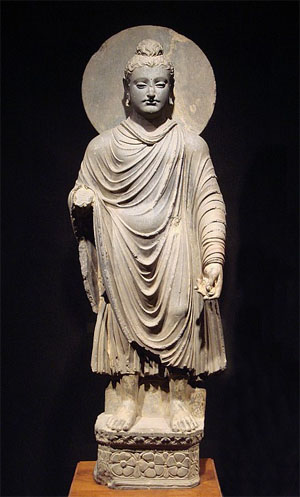
Gautama Buddha in Greco-Buddhist style, 1st–2nd century CE, Gandhara (Peshawar basin, modern day Pakistan).
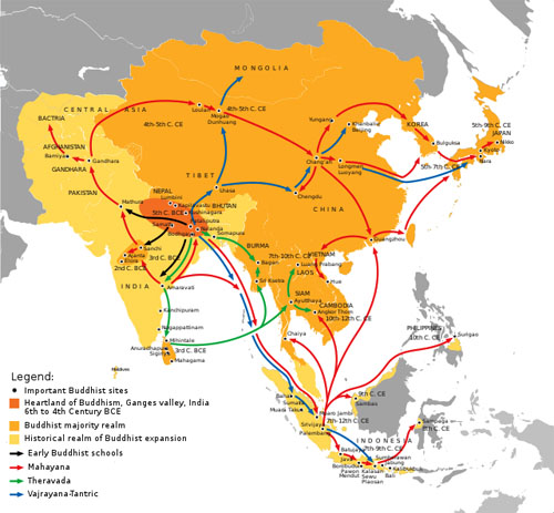
Buddhist expansion in Asia: Mahayana Buddhism first entered the Chinese Empire (Han dynasty) through Silk Road during the Kushan Era. The overland and maritime "Silk Roads" were interlinked and complementary, forming what scholars have called the "great circle of Buddhism".[1]
Greco-Buddhism, or Graeco-Buddhism, is the cultural syncretism between Hellenistic culture and Buddhism, which developed between the fourth century BCE and the fifth century CE in Bactria (modern-day Afghanistan and Tajikistan) and the Gandhara (modern-day Pakistan). It was a cultural consequence of a long chain of interactions begun by Greek forays into India (which originally meant the Indus region alone, not the rest of South Asia) from the time of Alexander the Great. The Macedonian satraps were then conquered by the Mauryan Empire, under the reign of Chandragupta Maurya. The Mauryan Emperor Ashoka would convert to Buddhism and spread the religious philosophy throughout his domain, as recorded in the Edicts of Ashoka.
Following the collapse of the Mauryan Empire, Greco-Buddhism continued to flourish under the Greco-Bactrian Kingdom, Indo-Greek Kingdoms, and Kushan Empire. Mahayana Buddhism was spread from Sanchi and Mathura in India into Gandhara and then Central Asia during the Mauryan Era, where it became the most prevalent branch of Buddhism in Central Asia. Mahayana Buddhism was later transmitted through the Silk Road into the Han Dynasty during the Kushan era under the reign of Emperor Kanishka.[clarification needed][Did Mahayana replace Greco-Buddhism? This intro suggests they are two names for the same thing.]
Historical outline
See also: History of Buddhism
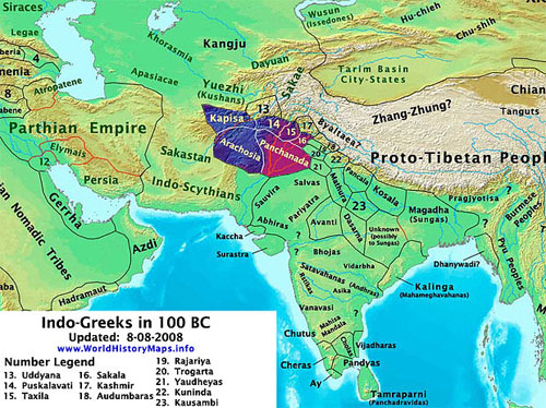
The Indo-Greek Kingdoms in 100 BCE.[2][3][4]
The introduction of Hellenistic Greece started when Alexander the Great conquered the Achaemenid Empire and further regions of Central Asia in 334 BCE. Alexander would then venture into Punjab (land of five rivers), which was conquered by Darius the Great before him. Alexander crossed the Indus and Jhelum River when defeating Porus and appointing him as a satrap following the Battle of the Hydaspes. Alexander's army would mutiny and retreat along the Beas River when confronted by the Nanda Empire, thus wouldn't conquer Punjab entirely.
Alexander founded several cities in his new territories in the areas of the Amu Darya and Bactria, and Greek settlements further extended to the Khyber Pass, Gandhara (see Taxila), and the Punjab. Following Alexander's death on June 10, 323 BCE, the Diadochi or "successors" founded their own kingdoms. General Seleucus set up the Seleucid Empire in Anatolia and Central Asia and extended as far as India.
The Mauryan Empire, founded by Chandragupta Maurya, would first conquer the Nanda Empire. Chandragupta would then defeat the Seleucid Empire during the Seleucid-Mauryan War. This resulted in the transfer of the Macedonian satraps in the Indus Valley and Gandhara to the Mauryan Empire. Furthermore, a marriage alliance was enacted which granted Seleucus's daughter as Chandragupta's wife for diplomatic relations. The conflict additionally led to the transfer of 500 war elephants to the Seleucid Empire from the Mauryan Empire, presumably as expenses of lives lost and damages sustained.
The Mauryan Emperor Ashoka established the largest Indian empire. Following the destructive Kalinga War, Ashoka converted to Buddhism. Abandoning an expansionist agenda, Ashoka would adopt humanitarian reformation in place.[5] As ascribed in the Edicts of Ashoka, the Emperor spread Dharma as Buddhism throughout his empire. Ashoka claims to have converted many, including the Greek populations within his realm to Buddhism:
The decline and overthrow of the Mauryans by the Shunga Empire, and of the revolt of Bactria in the Seleucid Empire led to the formation of the Greco-Bactrian Kingdom (250–125 BCE). The Greco-Bactrians were followed by the Indo-Greek Kingdom (180 BCE – CE 10). Even though the region was conquered by the Indo-Scythians and the Kushan Empire (1st–3rd centuries CE), Buddhism continued to thrive.
Buddhism in India was a major religion for centuries until a major Hindu revival from around the 5th century, with remaining strongholds such as Bengal largely ended during the Islamic invasions of India.
Cultural interaction
See also: Hellenistic influence on Indian art
The length of the Greek presence in Central Asia and northern India provided opportunities for interaction, not only on the artistic but also on the religious plane.
Alexander the Great in Bactria and India (331–325 BCE)
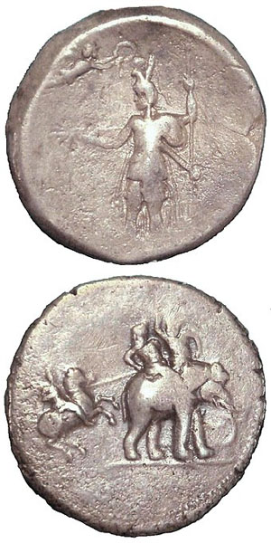
"Victory coin" of Alexander the Great, minted in Babylon c. 322 BCE, following his campaigns in India.
Obverse: Alexander being crowned by Nike.
Reverse: Alexander attacking King Porus on his elephant.
Silver. British Museum.
When Alexander invaded Bactria and Gandhara, these areas may already have been under Sramanic influence, likely Buddhist and Jain. According to a legend preserved in the Pali Canon, two merchant brothers from Kamsabhoga in Bactria, Tapassu and Bhallika, visited Gautama Buddha and became his disciples. The legend states that they then returned home and spread the Buddha's teaching.[7]
In 326 BCE, Alexander conquered the Northern region of India. King Ambhi of Taxila, known as Taxiles, surrendered his city, a notable Buddhist center, to Alexander. Alexander fought an epic battle against King Porus of Pauravas in Punjab, the Battle of the Hydaspes in 326 BCE.
Mauryan empire (322–183 BC)
See also: Greco-Buddhist monasticism
The Indian emperor Chandragupta Maurya, founder of the Maurya Empire, reconquered around 322 BC the northwest Indian territory that had been lost to Alexander the Great. However, contacts were kept with his Greco-Iranian neighbors in the Seleucid Empire. Emperor Seleucus I Nicator came to a marital agreement as part of a peace treaty,[8] and several Greeks, such as the historian Megasthenes, resided at the Mauryan court.
The Hellenistic Pataliputra capital, discovered in Pataliputra, capital of the Maurya Empire, dated to the 3rd century BC.
Chandragupta's grandson Ashoka embraced the Buddhist faith and became a great proselytizer in the line of the traditional Pali canon of Theravada Buddhism, insisting on non-violence to humans and animals (ahimsa), and general precepts regulating the life of laypeople.
According to the Edicts of Ashoka, set in stone, some of them written in Greek[9] and some in Aramaic, the official language of the Achaemenids, he sent Buddhist emissaries to the Greek lands in Asia and as far as the Mediterranean. The edicts name each of the rulers of the Hellenistic period:
Ashoka also claims he converted to Buddhism Greek populations within his realm:
Finally, some of the emissaries of Ashoka, such as the famous Dharmaraksita, are described in Pali sources as leading Greek ("Yona") Buddhist monks active in Buddhist proselytism (the Mahavamsa, XII[11]), founding the eponymous Dharmaguptaka school of Buddhism.[12]
Greek presence in Bactria (325–125 BC)
Main article: Greco-Bactrian Kingdom
The Greco-Bactrian city of Ai-Khanoum (c. 300–145 BC) was located at the doorstep of India.
Alexander had established in Bactria several cities (Ai-Khanoum, Bagram) and an administration that were to last more than two centuries under the Seleucid Empire and the Greco-Bactrian Kingdom, all the time in direct contact with Indian territory. The Greeks sent ambassadors to the court of the Maurya Empire, such as the historian Megasthenes under Chandragupta Maurya, and later Deimachus under his son Bindusara, who reported extensively on the civilization of the Indians. Megasthenes sent detailed reports on Indian religions, which were circulated and quoted throughout the Classical world for centuries:[13]
The Greco-Bactrians maintained a strong Hellenistic culture at the door of India during the rule of the Maurya Empire in India, as exemplified by the archaeological site of Ai-Khanoum. When the Maurya Empire was toppled by the Shunga Empire around 180 BC, the Greco-Bactrians expanded into India, where they established the Indo-Greek Kingdom, under which Buddhism was able to flourish.
Indo-Greek Kingdom and Buddhism (180 BC – AD 10)
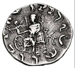
Greek Gods and the "Wheel of the Law" or Dharmachakra: Zeus holding Nike, who hands a victory wreath over a Dharmachakra (coin of Menander II).
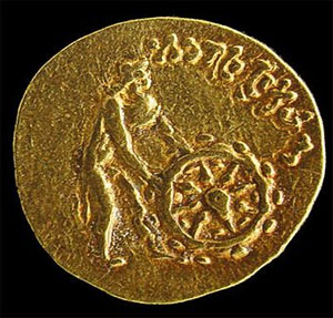
Greek Gods and the "Wheel of the Law" or Dharmachakra: Divinity wearing chlamys and petasus pushing a Dharmachakra, with legend "He who sets in motion the Wheel of the Law" (Tillya Tepe Buddhist coin).
Main article: Indo-Greek Kingdom
The Greco-Bactrians conquered parts of North India from 180 BC, whence they are known as the Indo-Greeks. They controlled various areas of the northern Indian territory until AD 10.
Buddhism prospered under the Indo-Greek kings, and it has been suggested that their invasion of India was intended to protect the Buddhist faith from the religious persecutions of the Shungas (185–73 BC), who had overthrown the Mauryans. Zarmanochegas was a śramana (possibly, but not necessarily a Buddhist) who, according to ancient historians such as Strabo, Cassius Dio and Nicolaus of Damascus traveled to Antioch and Athens while Augustus (died AD 14) was ruling the Roman Empire.[15][16]
Coinage
The coins of the Indo-Greek king Menander I (reigned 160–135 BC), found from Afghanistan to central India, bear the inscription "Saviour King Menander" in Greek on the front. Several Indo-Greek kings after Menander, such as Zoilos I, Strato I, Heliokles II, Theophilos, Peukolaos, Menander II and Archebius display on their coins the title "Maharajasa Dharmika" (lit. "King of the Dharma") in Prakrit written in Kharoshthi.
Some of the coins of Menander I and Menander II incorporate the Buddhist symbol of the eight-spoked wheel, associated with the Greek symbols of victory, either the palm of victory, or the victory wreath handed over by the goddess Nike. According to the Milinda Pañha, at the end of his reign Menander I became a Buddhist arhat,[17] a fact also echoed by Plutarch, who explains that his relics were shared and enshrined.[18]
A coin of Menander I (r.160–135 BC) with a dharmacakra and a palm.
The ubiquitous symbol of the elephant in Indo-Greek coinage may also have been associated with Buddhism, as suggested by the parallel between coins of Antialcidas and Menander II, where the elephant in the coins of Antialcidas holds the same relationship to Zeus and Nike as the Buddhist wheel on the coins of Menander II. When the Zoroastrian Indo-Parthian Kingdom invaded North India in the 1st century AD, they adopted a large part of the symbolism of Indo-Greek coinage, but refrained from ever using the elephant, suggesting that its meaning was not merely geographical.
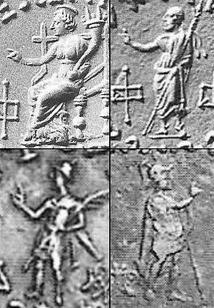
Vitarka Mudra gestures on Indo-Greek coinage. Top: Divinities Tyche and Zeus. Bottom: Depiction of the Indo-Greek kings Nicias and Menander II.
Finally, after the reign of Menander I, several Indo-Greek rulers, such as Amyntas Nikator, Nicias, Peukolaos, Hermaeus, Hippostratos and Menander II, depicted themselves or their Greek deities forming with the right hand a benediction gesture identical to the Buddhist vitarka mudra (thumb and index joined together, with other fingers extended), which in Buddhism signifies the transmission of Buddha's teaching.
Cities
According to Ptolemy, Greek cities were founded by the Greco-Bactrians in northern India. Menander established his capital in Sagala (modern Sialkot, Punjab, Pakistan) one of the centers of the blossoming Buddhist culture.[19] A large Greek city built by Demetrius and rebuilt by Menander has been excavated at the archaeological site of Sirkap near Taxila, where Buddhist stupas were standing side-by-side with Hindu and Greek temples, indicating religious tolerance and syncretism.
Scriptures
Evidence of direct religious interaction between Greek and Buddhist thought during the period include the Milinda Pañha or "Questions of Menander", a Pali-language discourse in the Platonic style held between Menander I and the Buddhist monk Nagasena.
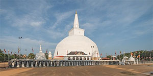
According to the Mahavamsa, the Ruwanwelisaya in Anuradhapura, Sri Lanka, was dedicated by a 30,000-strong Yona delegation from Alexandria on the Caucasus around 130 BC.
The Mahavamsa, chapter 29, records that during Menander's reign, a Greek thera (elder monk) named Mahadharmaraksita led 30,000 Buddhist monks from "the Greek city of Alexandria" (possibly Alexandria on the Caucasus, around 150 kilometres (93 mi) north of today's Kabul in Afghanistan), to Sri Lanka for the dedication of a stupa, indicating that Buddhism flourished in Menander's territory and that Greeks took a very active part in it.[20]
Several Buddhist dedications by Greeks in India are recorded, such as that of the Greek meridarch (civil governor of a province) named Theodorus, describing in Kharosthi how he enshrined relics of the Buddha. The inscriptions were found on a vase inside a stupa, dated to the reign of Menander or one of his successors in the 1st century BC.[21] Finally, Buddhist tradition recognizes Menander as one of the great benefactors of the faith, together with Ashoka and Kanishka the Great.
Buddhist manuscripts in cursive Greek have been found in Afghanistan, praising various Buddhas and including mentions of the Mahayana figure of "Lokesvararaja Buddha" (λωγοασφαροραζοβοδδο). These manuscripts have been dated later than the 2nd century AD.[22]
Kushan empire (1st–3rd century AD)
Main article: Kushan Empire
The Kushan Empire, one of the five tribes of the Yuezhi, settled in Bactria around 125 BC, displacing the Greco-Bactrians and invading the northern parts of Pakistan and India from around AD 1. By that time they had already been in contact with Greek culture and the Indo-Greek kingdoms for more than a century. They used the Greek script to write their language, as exemplified by their coins and their adoption of the Greek alphabet.
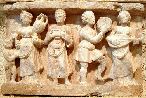
Hellenistic culture in the Indian subcontinent: Greek clothes, amphoras, wine and music. Detail from Chakhil-i-Ghoundi Stupa, Hadda, Gandhara, 1st century AD.
The Kushan King Kanishka, who honored Zoroastrian, Greek and Brahmanic deities as well as the Buddha and was famous for his religious syncretism, convened the Fourth Buddhist council around 100 in Kashmir in order to redact the Sarvastivadin canon. Some of Kanishka's coins bear the earliest representations of the Buddha on a coin (around 120), in Hellenistic style and with the word "Boddo" in Greek script.
Kanishka also had the original Gandhari Prakrit Mahāyāna sūtras translated into Sanskrit, "a turning point in the evolution of the Buddhist literary canon"[23]
The Kanishka casket, dated to the first year of Kanishka's reign in 127, was signed by a Greek artist named Agesilas, who oversaw work at Kanishka's stupas (cetiya), confirming the direct involvement of Greeks with Buddhist realizations at such a late date.
Philosophical influences
Several Greek philosophers, including Pyrrho, Anaxarchus, and Onesicritus accompanied Alexander in his eastern campaigns. During the 18 months they were in India, they were able to interact with Indian philosophers who pursued asceticism, generally described as gymnosophists ("naked philosophers").[24]
Pyrrhonism
Main article: Similarities between Pyrrhonism and Buddhism
Pyrrho returned to Greece and founded Pyrrhonism, considered by modern scholars as the first Western school of skepticism.[25] The Greek biographer Diogenes Laërtius explained that Pyrrho's equanimity and detachment from the world were acquired in India.[25][26]
Pyrrho was directly influenced by Buddhism in developing his philosophy, which is based on Pyrrho's interpretation of the Buddhist three marks of existence.[25][27]
Cynicism
Another of these philosophers, Onesicritus, a Cynic, is said by Strabo to have learnt in India the following precepts: "That nothing that happens to a man is bad or good, opinions being merely dreams. ... That the best philosophy [is] that which liberates the mind from [both] pleasure and grief".[14] Cynicism, particularly the Cynic Peregrinus Proteus was further influenced by the tales of the gymnosophists, particularly the examples set by Kalanos, Dandamis, and Zarmanochegas.[citation needed]
Cyrenaicism
The Cyrenaic philosopher Hegesias of Cyrene, from the city of Cyrene where Magas of Cyrene ruled, is thought by some to have been influenced by the teachings of Ashoka's Buddhist missionaries.[28]
Artistic influences
Main article: Greco-Buddhist art
Numerous works of Greco-Buddhist art display the intermixing of Greek and Buddhist influences in such creation centers as Gandhara. The subject matter of Gandharan art was definitely Buddhist, while most motifs were of Western Asiatic or Hellenistic origin.
Anthropomorphic representation of the Buddha
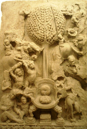
An aniconic representation of Mara's assault on the Buddha, 2nd century AD, Amaravathi village, Guntur district, India.
Although there is still some debate, the first anthropomorphic representations of the Buddha himself are often considered a result of the Greco-Buddhist interaction. Before this innovation, Buddhist art was "aniconic": the Buddha was only represented through his symbols (an empty throne, the Bodhi Tree, Buddha footprints, the Dharmachakra).
This reluctance towards anthropomorphic representations of the Buddha, and the sophisticated development of aniconic symbols to avoid it (even in narrative scenes where other human figures would appear), seem to be connected to one of the Buddha's sayings reported in the Digha Nikaya that discouraged representations of himself after the extinction of his body.[29]
Probably not feeling bound by these restrictions, and because of "their cult of form, the Greeks were the first to attempt a sculptural representation of the Buddha".[30] In many parts of the Ancient World, the Greeks did develop syncretic divinities, that could become a common religious focus for populations with different traditions: a well-known example is Serapis, introduced by Ptolemy I Soter in Egypt, who combined aspects of Greek and Egyptian Gods. In India as well, it was only natural for the Greeks to create a single common divinity by combining the image of a Greek god-king (Apollo, or possibly the deified founder of the Indo-Greek Kingdom, Demetrius I of Bactria), with the traditional physical characteristics of the Buddha.
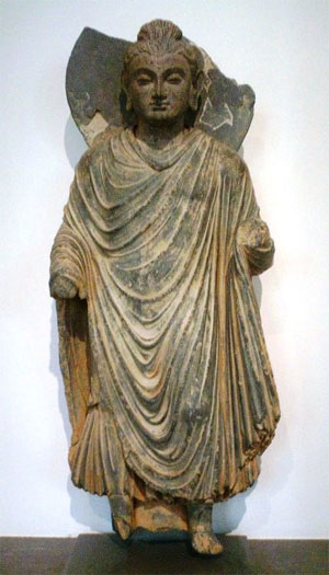
Standing Buddha, Gandhara, 1st century AD.
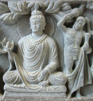
Herculean depiction of Vajrapani (right), as the protector of the Buddha, 2nd century AD Gandhara, British Museum.
Many of the stylistic elements in the representations of the Buddha point to Greek influence: himation, the contrapposto stance of the upright figures, such as the 1st–2nd century Gandhara standing Buddhas, the stylized curly hair and ushnisha apparently derived from the style of the Apollo Belvedere (330 BC) and the measured quality of the faces, all rendered with strong artistic realism. A large quantity of sculptures combining Buddhist and purely Hellenistic styles and iconography were excavated at the modern site of Hadda, Afghanistan. The curly hair of Buddha is described in the famous list of the physical characteristics of the Buddha in the Buddhist sutras. The hair with curls turning to the right is first described in the Pāli canon; we find the same description in the Dāsāṣṭasāhasrikā prajñāpāramitā.[citation needed]
Greek artists were most probably the authors of these early representations of the Buddha, in particular the standing statues, which display "a realistic treatment of the folds and on some even a hint of modelled volume that characterizes the best Greek work. This is Classical or Hellenistic Greek, not archaizing Greek transmitted by Persia or Bactria, nor distinctively Roman."[31]
The Greek stylistic influence on the representation of the Buddha, through its idealistic realism, also permitted a very accessible, understandable and attractive visualization of the ultimate state of enlightenment described by Buddhism, allowing it to reach a wider audience:
During the following centuries, this anthropomorphic representation of the Buddha defined the canon of Buddhist art, but progressively evolved to incorporate more Indian and Asian elements.
Hellenized Buddhist pantheon
See also: Buddhist art and Greco-Buddhist art
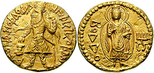
A Buddhist coin of Kanishka I, with legend ΒΟΔΔΟ "Boddo" (=the Buddha) in Greek script on the reverse.
Several other Buddhist deities may have been influenced by Greek gods. For example, Heracles with a lion-skin, the protector deity of Demetrius I of Bactria, "served as an artistic model for Vajrapani, a protector of the Buddha".[33][34] In Japan, this expression further translated into the wrath-filled and muscular Niō guardian gods of the Buddha, standing today at the entrance of many Buddhist temples.
According to Katsumi Tanabe, professor at Chūō University, Japan, besides Vajrapani, Greek influence also appears in several other gods of the Mahayana pantheon such as the Japanese Fūjin, inspired from the Greek divinity Boreas through the Greco-Buddhist Wardo, or the mother deity Hariti inspired by Tyche.[35]
In addition, forms such as garland-bearing cherubs, vine scrolls, and such semihuman creatures as the centaur and triton, are part of the repertory of Hellenistic art introduced by Greco-Roman artists in the service of the Kushan court.
Exchanges
Gandharan proselytism in the East
See also: Silk Road transmission of Buddhism, Greco-Buddhist monasticism, and Dayuan
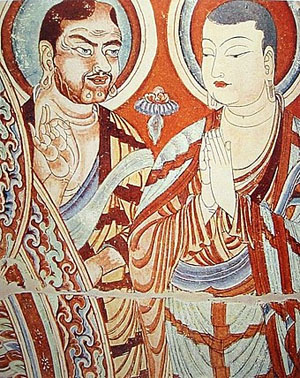
Blue-eyed Central Asian monk teaching East-Asian monk. A fresco from the Bezeklik Thousand Buddha Caves, dated to the 9th or 10th century (Kara-Khoja Kingdom).
Greek monks played a direct role in the upper hierarchy of Buddhism, and in its early dissemination. During the rule (165–135 BC) of the Greco-Bactrian King Menander I (Pali: "Milinda"), Mahadharmaraksita (literally translated as 'Great Teacher/Preserver of the Dharma') was "a Greek (Pali: Yona, lit. Ionian) Buddhist head monk," according to the Mahavamsa (Chap. XXIX), who led 30,000 Buddhist monks from "the Greek city of Alasandra" (Alexandria of the Caucasus, around 150 km north of today's Kabul in Afghanistan), to Sri Lanka for the dedication of the Great Stupa in Anuradhapura. Dharmaraksita (Sanskrit), or Dhammarakkhita (Pali) (translation: Protected by the Dharma), was one of the missionaries sent by the Mauryan emperor Ashoka to proselytize the Buddhist faith. He is described as being a Greek (Pali: "Yona", lit. "Ionian") in the Mahavamsa, and his activities are indicative of the strength of the Hellenistic Greek involvement during the formative centuries of Buddhism. Indeed, Menander I was famously converted to Buddhism by Nagasena, who was a student of the Greek Buddhist monk Dharmaraksita. Menander is said to have reached enlightenment as an arhat under Nagasena's guidance and is recorded as a great patron of Buddhism. The dialogue of the Greek King Menander I (Pali "Milinda") with the monk Nagasena comprises the Pali Buddhist work known as the Milinda Panha.
Buddhist monks from the region of Gandhara in Pakistan , where Greco-Buddhism was most influential, later played a key role in the development and the transmission of Buddhist ideas in the direction of northern Asia. Greco-Buddhist Kushan monks such as Lokaksema (c. AD 178) travelled to the Chinese capital of Loyang, where they became the first translators of Buddhist scriptures into Chinese.[36] Central Asian and East Asian Buddhist monks appear to have maintained strong exchanges until around the 10th century, as indicated by the Bezeklik Thousand Buddha Caves frescos from the Tarim Basin. In legend too Bodhidharma, the founder of Chán-Buddhism, which later became Zen, and the legendary originator of the physical training of the Shaolin monks that led to the creation of Shaolin Kung Fu, is described as a Buddhist monk from Central Asia in the first Chinese references to him (Yan Xuan-Zhi in 547).[37] Throughout Buddhist art, Bodhidharma is depicted as a rather ill-tempered, profusely bearded and wide-eyed barbarian, and he is referred as "The Blue-Eyed Barbarian" (碧眼胡; Bìyǎn hú) in Chinese Chan texts.[38] In 485, according to the 7th century Chinese historical treatise Liang Shu, five monks from Gandhara travelled to the country of Fusang ("The country of the extreme East" beyond the sea, probably eastern Japan), where they introduced Buddhism:
Two half-brothers from Gandhara, Asanga and Vasubandhu (4th century), created the Yogacara or "Mind-only" school of Mahayana Buddhism, which through one of its major texts, the Lankavatara Sutra, became a founding block of Mahayana, and particularly Zen, philosophy.
Greco-Buddhism in the West
Kandahar Bilingual Rock Inscription (Greek and Aramaic) 3rd century BC by Indian Buddhist King Ashoka. This edict advocates the adoption of "godliness" using the Greek term Eusebeia for Dharma. Kabul Museum.
Intense westward physical exchange at that time along the Silk Road is confirmed by the Roman craze for silk from the 1st century BC to the point that the Senate issued, in vain, several edicts to prohibit the wearing of silk, on economic and moral grounds. This is attested by at least three authors: Strabo (64/63 BC – c. AD 24), Seneca the Younger (c. 3 BC – AD 65), and Pliny the Elder (AD 23–79). The aforementioned Strabo and Plutarch (c. 45–125) also wrote about Indo-Greek Buddhist king Menander, confirming that information about the Indo-Greek Buddhists was circulating throughout the Hellenistic world.
Zarmanochegas (Zarmarus) (Ζαρμανοχηγὰς) was a monk of the Sramana tradition (possibly, but not necessarily a Buddhist) who, according to ancient historians such as Strabo and Dio Cassius, met Nicholas of Damascus in Antioch while Augustus (died AD 14) was ruling the Roman Empire, and shortly thereafter proceeded to Athens where he burnt himself to death.[15][16] His story and tomb in Athens were well-known over a century later. Plutarch (died AD 120) in his Life of Alexander, after discussing the self-immolation of Calanus of India (Kalanos) witnessed by Alexander writes: "The same thing was done long after by another Indian who came with Caesar to Athens, where they still show you 'the Indian's Monument,'"[39] referring to Zarmanochegas' tomb in Roman Athens.
Another century later the Christian church father Clement of Alexandria (died 215) mentioned Buddha by name in his Stromata (Bk I, Ch XV): "The Indian gymnosophists are also in the number, and the other barbarian philosophers. And of these there are two classes, some of them called Sarmanæ and others Brahmins. And those of the Sarmanæ who are called "Hylobii" neither inhabit cities, nor have roofs over them, but are clothed in the bark of trees, feed on nuts, and drink water in their hands. Like those called Encratites in the present day, they know not marriage nor begetting of children. Some, too, of the Indians obey the precepts of Buddha (Βούττα) whom, on account of his extraordinary sanctity, they have raised to divine honours."[40]
Indian gravestones from the Ptolemaic period have been found in Alexandria in Egypt.[41] The presence of Buddhists in Alexandria at this time is important, since "It was later in this very place that some of the most active centers of Christianity were established".[42]
The pre-Christian monastic order of the Therapeutae is possibly a deformation of the Pāli word "Theravāda",[43] a form of Buddhism, and the movement may have "almost entirely drawn (its) inspiration from the teaching and practices of Buddhist asceticism".[42] They may even have been descendants of Asoka's emissaries to the West.[44] While Philo of Alexandria's description of the doctrines and practices of the Therapeutae leaves great ambiguity about what religion they are associated with, analysis by religious scholar Ullrich R. Kleinhempel indicates that the most likely religion the Therapeutae practiced was Buddhism.[45]
Buddhism and Christianity
Main articles: Buddhism and Christianity and Buddhist influences on Christianity
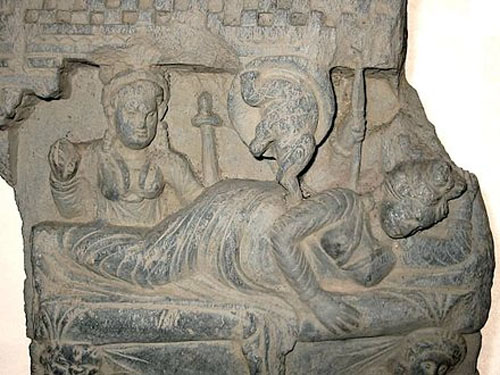
Queen Māyā's white elephant dream, and the conception of the Buddha. Gandhara, 2nd–3rd century AD.
Although the philosophical systems of Buddhism and Christianity have evolved in rather different ways, the moral precepts advocated by Buddhism from the time of Ashoka through his edicts do have some similarities with the Christian moral precepts developed more than two centuries later: respect for life, respect for the weak, rejection of violence, pardon to sinners, tolerance.
One theory is that these similarities may indicate the propagation of Buddhist ideals into the Western World, with the Greeks acting as intermediaries and religious syncretists.[46]
The story of the birth of the Buddha was well known in the West, and possibly influenced the story of the birth of Jesus: Saint Jerome (4th century) mentions the birth of the Buddha, who he says "was born from the side of a virgin,"[47] and the influential early Christian church father Clement of Alexandria (died 215) mentioned Buddha (Βούττα) in his Stromata (Bk I, Ch XV).[40] The legend of Christian saints Barlaam and Josaphat draws on the life of the Buddha.[48]
See also
• Greco-Bactrian Kingdom
• Gandharan Buddhism
• Gandhāran Buddhist texts
• Greco-Buddhist Art
• Indo-Greek Kingdom
• Milinda Pañha
• Nāgasena
• Religions of the Indo-Greeks
• Silk road transmission of Buddhism
• Buddhism in Central Asia
• Buddhas of Bamyan
• Kushan Empire
• Ancient Greece–Ancient India relations
• Index of Buddhism-related articles
Notes
1. Acri, Andrea (20 December 2018). "Maritime Buddhism". Oxford Research Encyclopedia of Religion. Oxford: Oxford University Press. doi:10.1093/acrefore/9780199340378.013.638. ISBN 9780199340378. Archived from the original on 19 February 2019. Retrieved 30 May 2021.
2. Davies, Cuthbert Collin (1959). An Historical Atlas of the Indian Peninsula. Oxford University Press.
3. Narain, A.K. (1976). The Coin Types of the Indo-Greek Kings, 256-54 B.C. Ares. ISBN 0-89005-109-7.
4. Stier, Hans Erich; Kirsten, Ernst; Aner, Ekkehard (1978). Grosser Atlas zur Weltgeschichte: Vorzeit, Altertum, Mittelalter, Neuzeit. Georg Westermann Verlag. ISBN 3-14-100919-8.
5. Draper, Gerald (1995). "The Contribution of the Emperor Asoka Maurya to the Development of the Humanitarian Ideal in Warfare". International Review of the Red Cross. 35 (305): 192–206. doi:10.1017/S0020860400090604.
6. Rock Edict Nb13 (S. Dhammika)
7. Foltz, Religions of the Silk Road, p. 43
8. "The whole region from Phrygia to the Indus was subject to Seleucus. He crossed the Indus and waged war with Sandrocottus [Chandragupta], king of the Indians, who dwelt on the banks of that stream until they came to an understanding with each other and contracted a marriage relationship. Some of these exploits were performed before the death of Antigonus and some afterward." AppianHistory of Rome, The Syrian Wars 55
9. For an English translation of the Greek edicts: Religions and Trade: Religious Formation, Transformation and Cross-Cultural Exchange between East and West. BRILL. 2 December 2013. pp. 65–. ISBN 978-90-04-25530-2.
10. Rock Edict Nb.13, Full text of the Edicts of Ashoka. See Rock Edict 13 Archived 2013-10-28 at the Wayback Machine
11. "Chapter XII". 20 October 2014. Archived from the original on 2014-10-20.
12. "Abstract Sujato: Sects & Sectarianism". http://www.congress-on-buddhist-women.org.
13. Surviving fragments of Megasthenes:Full text
14. Strabo, XV.I.65: "Strabo XV.1". Perseus.tufts.edu. Retrieved 2010-09-01.
15. Strabo, xv, 1, on the immolation of the Sramana in Athens (Paragraph 73).
16. Dio Cassius, liv, 9.
17. Extract of the Milinda Panha: "And afterwards, taking delight in the wisdom of the Elder, he handed over his kingdom to his son, and abandoning the household life for the houseless state, grew great in insight, and himself attained to Arahatship!" (The Questions of King Milinda, Translation by T. W. Rhys Davids, 1890)
18. Plutarch on Menander: "But when one Menander, who had reigned graciously over the Bactrians, died afterwards in the camp, the cities indeed by common consent celebrated his funerals; but coming to a contest about his relics, they were difficultly at last brought to this agreement, that his ashes being distributed, everyone should carry away an equal share, and they should all erect monuments to him." (Plutarch, "Political Precepts" Praec. reip. ger. 28, 6) p147–148 Full text
19. Milinda Panha, Chap. I
20. Thomas McEvilley (7 February 2012). The Shape of Ancient Thought: Comparative Studies in Greek and Indian Philosophies. Constable & Robinson. pp. 558–. ISBN 978-1-58115-933-2.
21. Tarn, William Woodthorpe (24 June 2010). The Greeks in Bactria and India. Cambridge University Press. p. 391. ISBN 978-1-108-00941-6.
22. Nicholas Sims-Williams, "A Bactrian Buddhist Manuscript"
23. Foltz, Religions of the Silk Road, p. 45
24. Stoneman, Richard (2019). "The Indian Philosophers and the Greeks". The Greek Experience of India: From Alexander to the Indo-Greeks. Oxford and Princeton: Princeton University Press. pp. 289–331. doi:10.1515/9780691185385-015. ISBN 978-0-691-15403-9. JSTOR j.ctv3znwg5. LCCN 2018958249. S2CID 166488882.
25. Stoneman, Richard (2019). "Two Hundred Years of Debate: Greek and Indian Thought". The Greek Experience of India: From Alexander to the Indo-Greeks. Oxford and Princeton: Princeton University Press. pp. 346–355. doi:10.1515/9780691185385-016. ISBN 978-0-691-15403-9. JSTOR j.ctv3znwg5. LCCN 2018958249. S2CID 166488882.
26. "He would withdraw from the world and live in solitude, rarely showing himself to his relatives; this is because he had heard an Indian reproach Anaxarchus, telling him that he would never be able to teach others what is good while he himself danced attendance on kings in their court. He would maintain the same composure at all times." (Diogenes Laertius, IX.63 on Pyrrhon)
27. Beckwith, Christopher I. (2015). Greek Buddha: Pyrrho's Encounter with Early Buddhism in Central Asia (PDF). Princeton University Press. p. 28. ISBN 9781400866328.
28. "The philosopher Hegesias of Cyrene (nicknamed Peisithanatos, "The advocate of death") was a contemporary of Magas and was probably influenced by the teachings of the Buddhist missionaries to Cyrene and Alexandria. His influence was such that he was ultimately prohibited from teaching." Lafont, Jean-Marie (2000). "La découverte du bouddhisme par le monde européen". Les Dossiers d'Archéologie (in French). No. 254: 78–85 [p. 78]. ISSN 1141-7137.
29. "Due to the statement of the Master in the Dighanikaya disfavouring his representation in human form after the extinction of body, reluctance prevailed for some time". Also "Hinayanis opposed image worship of the Master due to canonical restrictions". R.C. Sharma, in "The Art of Mathura, India", Tokyo National Museum 2002, p.11
30. Linssen; Robert (1958). Living Zen. London: Allen & Unwin. p. 206.
31. Boardman p. 126
32. 14th Dalai Lama, foreword to "Echoes of Alexander the Great", 2000.
33. Foltz (2010). Religions of the Silk Road. p. 44.
34. See Images of the Herakles-influenced Vajrapani: "Image 1". Archived from the original on December 16, 2013, "Image 2". Archived from the original on March 13, 2004.
35. Tanabe, Katsumi (2003). Alexander the Great: East-West Cultural Contact from Greece to Japan. Tokyo: NHK Puromōshon and Tokyo National Museum. OCLC 937316326.
36. Foltz, Richard (2010). Religions of the Silk Road (2nd ed.). Palgrave Macmillan. p. 46. ISBN 978-0-230-62125-1.
37. Broughton, Jeffrey L. (1999). The Bodhidharma Anthology: The Earliest Records of Zen. Berkeley: University of California Press. pp. 54–55. ISBN 0-520-21972-4.
38. Soothill, William Edward; Hodous, Lewis (1995). A Dictionary of Chinese Buddhist Terms(PDF). London: RoutledgeCurzon. Archived from the original (PDF) on March 3, 2014.
39. Plutarch. "Life of Alexander". The Lives of the Noble Grecians and Romans. The Modern Library. Translated by Dryden, John; Clough, Arthur Hugh. New York: Random House. p. 850.
40. "Clement of Alexandria Stromata. BkI, Ch XV". Retrieved 19 Dec 2012.
41. Tarn. The Greeks in Bactria and India. p. 370.
42. Linssen; Robert (1958). Living Zen. London: Allen & Unwin. p. 208.
43. According to the linguist Zacharias P. Thundy[full citation needed]
44. Gruber, Elmar R.; Kersten, Holger (1995). The Original Jesus. Shaftesbury: Element Books. ISBN 1-85230-835-4.
45. Ullrich R . Kleinhempel, "Traces of Buddhist Presence in Alexandria: Philo and the "Therapeutae"", Научно-теоретический журнал 2019 https://www.academia.edu/39841429/Trace ... erapeutae_
46. Foltz. Religions of the Silk Road. p. 44. Certain Indian notions may have made their way westward into the budding Christianity of the Mediterranean world through the channels of the Greek diaspora
47. McEvilley, p391
48. Walbridge, John (2001). The Wisdom of the Mystic East: Suhrawardī and Platonic Orientalism. p. 129. The form Būdhīsaf is the original, as shown by Sogdian form Pwtysfi and the early New Persian form Bwdysf On the Christian versions see A. S. Geden, Encyclopaedia of Religion and Ethics, s.v. "Josaphat, Barlaam and," and M. P. Alfaric, ..."
References
• Vassiliades, Demetrios Th. 2016. Greeks and Buddhism. Athens, Indo-Hellenic Society for Culture & Development ELINEPA.
• Alexander the Great: East-West Cultural Contacts from Greece to Japan. Tokyo: NHK Puromōshon and Tokyo National Museum, 2003.
• Baums, Stefan. 2012. “Catalog and Revised Texts and Translations of Gandharan Reliquary Inscriptions.” In: David Jongeward, Elizabeth Errington, Richard Salomon and Stefan Baums, Gandharan Buddhist Reliquaries, p. 204, Seattle: Early Buddhist Manuscripts Project (Gandharan Studies, Volume 1).
• Baums, Stefan, and Andrew Glass. 2002– . Catalog of Gāndhārī Texts, no. CKI 32
• Jerry H. Bentley. Old World Encounters: Cross-cultural Contacts and Exchanges in Pre-modern Times. Oxford–NY: Oxford University Press, 1993. ISBN 0-19-507639-7
• John Boardman. The Diffusion of Classical Art in Antiquity. Princeton, NJ: Princeton University Press, 1994. ISBN 0-691-03680-2
• Shravasti Dhammika, trans. The Edicts of King Asoka: An English Rendering. Kandy, Sri Lanka: Buddhist Publication Society, 1993. ISBN 955-24-0104-6
• Richard Foltz. Religions of the Silk Road, 2nd edition, New York: Palgrave Macmillan, 2010 ISBN 978-0-230-62125-1
• Georgios T. Halkias, “When the Greeks Converted the Buddha: Asymmetrical Transfers of Knowledge in Indo-Greek Cultures”, in Trade and Religions: Religious Formation, Transformation and Cross-Cultural Exchange between East and West, ed. Volker Rabens. Leiden: Brill, 2013, p. 65–115.
• Robert Linssen. Living Zen. NY: Grove Press, 1958. ISBN 0-8021-3136-0
• Lowenstein, Tom (1996). The vision of the Buddha. Duncan Baird Publishers. ISBN 1-903296-91-9.
• Thomas McEvilley. The Shape of Ancient Thought: Comparative Studies in Greek and Indian Philosophies. NY: Allworth Press and the School of Visual Arts, 2002. ISBN 1-58115-203-5
• William Woodthorpe Tarn. The Greeks in Bactria and India. Cambridge: Cambridge University Press, 1951, ISBN 81-215-0220-9
• Marian Wenzel. Echoes of Alexander the Great: Silk Route Portraits from Gandhara, foreword by the Dalai Lama. Eklisa Anstalt, 2000. ISBN 1-58886-014-0
• Paul Williams. Mahāyāna Buddhism: the Doctrinal Foundations. London–NY: Routledge, 1989. ISBN 0-415-02537-0
External links
• UNESCO: Threatened Greco-Buddhist art
• Alexander the Great: East-West Cultural contacts from Greece to Japan (Japanese)
• The Hellenistic age
• The Kanishka Buddhist coins
• Interim period: Mathura as the Vaishnava-Buddhist seat of culture and learning
by Wikipedia
Accessed: 9/3/21
Gautama Buddha in Greco-Buddhist style, 1st–2nd century CE, Gandhara (Peshawar basin, modern day Pakistan).
Buddhist expansion in Asia: Mahayana Buddhism first entered the Chinese Empire (Han dynasty) through Silk Road during the Kushan Era. The overland and maritime "Silk Roads" were interlinked and complementary, forming what scholars have called the "great circle of Buddhism".[1]
Greco-Buddhism, or Graeco-Buddhism, is the cultural syncretism between Hellenistic culture and Buddhism, which developed between the fourth century BCE and the fifth century CE in Bactria (modern-day Afghanistan and Tajikistan) and the Gandhara (modern-day Pakistan). It was a cultural consequence of a long chain of interactions begun by Greek forays into India (which originally meant the Indus region alone, not the rest of South Asia) from the time of Alexander the Great. The Macedonian satraps were then conquered by the Mauryan Empire, under the reign of Chandragupta Maurya. The Mauryan Emperor Ashoka would convert to Buddhism and spread the religious philosophy throughout his domain, as recorded in the Edicts of Ashoka.
Following the collapse of the Mauryan Empire, Greco-Buddhism continued to flourish under the Greco-Bactrian Kingdom, Indo-Greek Kingdoms, and Kushan Empire. Mahayana Buddhism was spread from Sanchi and Mathura in India into Gandhara and then Central Asia during the Mauryan Era, where it became the most prevalent branch of Buddhism in Central Asia. Mahayana Buddhism was later transmitted through the Silk Road into the Han Dynasty during the Kushan era under the reign of Emperor Kanishka.[clarification needed][Did Mahayana replace Greco-Buddhism? This intro suggests they are two names for the same thing.]
Historical outline
See also: History of Buddhism
The Indo-Greek Kingdoms in 100 BCE.[2][3][4]
The introduction of Hellenistic Greece started when Alexander the Great conquered the Achaemenid Empire and further regions of Central Asia in 334 BCE. Alexander would then venture into Punjab (land of five rivers), which was conquered by Darius the Great before him. Alexander crossed the Indus and Jhelum River when defeating Porus and appointing him as a satrap following the Battle of the Hydaspes. Alexander's army would mutiny and retreat along the Beas River when confronted by the Nanda Empire, thus wouldn't conquer Punjab entirely.
Alexander founded several cities in his new territories in the areas of the Amu Darya and Bactria, and Greek settlements further extended to the Khyber Pass, Gandhara (see Taxila), and the Punjab. Following Alexander's death on June 10, 323 BCE, the Diadochi or "successors" founded their own kingdoms. General Seleucus set up the Seleucid Empire in Anatolia and Central Asia and extended as far as India.
The Mauryan Empire, founded by Chandragupta Maurya, would first conquer the Nanda Empire. Chandragupta would then defeat the Seleucid Empire during the Seleucid-Mauryan War. This resulted in the transfer of the Macedonian satraps in the Indus Valley and Gandhara to the Mauryan Empire. Furthermore, a marriage alliance was enacted which granted Seleucus's daughter as Chandragupta's wife for diplomatic relations. The conflict additionally led to the transfer of 500 war elephants to the Seleucid Empire from the Mauryan Empire, presumably as expenses of lives lost and damages sustained.
The Mauryan Emperor Ashoka established the largest Indian empire. Following the destructive Kalinga War, Ashoka converted to Buddhism. Abandoning an expansionist agenda, Ashoka would adopt humanitarian reformation in place.[5] As ascribed in the Edicts of Ashoka, the Emperor spread Dharma as Buddhism throughout his empire. Ashoka claims to have converted many, including the Greek populations within his realm to Buddhism:
Here in the king's domain among the Greeks, the Kambojas, the Nabhakas, the Nabhapamkits, the Bhojas, the Pitinikas, the Andhras, and the Palidas, everywhere people are following Beloved-of-the-Gods' instructions in Dharma.[6]
The decline and overthrow of the Mauryans by the Shunga Empire, and of the revolt of Bactria in the Seleucid Empire led to the formation of the Greco-Bactrian Kingdom (250–125 BCE). The Greco-Bactrians were followed by the Indo-Greek Kingdom (180 BCE – CE 10). Even though the region was conquered by the Indo-Scythians and the Kushan Empire (1st–3rd centuries CE), Buddhism continued to thrive.
Buddhism in India was a major religion for centuries until a major Hindu revival from around the 5th century, with remaining strongholds such as Bengal largely ended during the Islamic invasions of India.
Cultural interaction
See also: Hellenistic influence on Indian art
The length of the Greek presence in Central Asia and northern India provided opportunities for interaction, not only on the artistic but also on the religious plane.
Alexander the Great in Bactria and India (331–325 BCE)
"Victory coin" of Alexander the Great, minted in Babylon c. 322 BCE, following his campaigns in India.
Obverse: Alexander being crowned by Nike.
Reverse: Alexander attacking King Porus on his elephant.
Silver. British Museum.
When Alexander invaded Bactria and Gandhara, these areas may already have been under Sramanic influence, likely Buddhist and Jain. According to a legend preserved in the Pali Canon, two merchant brothers from Kamsabhoga in Bactria, Tapassu and Bhallika, visited Gautama Buddha and became his disciples. The legend states that they then returned home and spread the Buddha's teaching.[7]
In 326 BCE, Alexander conquered the Northern region of India. King Ambhi of Taxila, known as Taxiles, surrendered his city, a notable Buddhist center, to Alexander. Alexander fought an epic battle against King Porus of Pauravas in Punjab, the Battle of the Hydaspes in 326 BCE.
Mauryan empire (322–183 BC)
See also: Greco-Buddhist monasticism
The Indian emperor Chandragupta Maurya, founder of the Maurya Empire, reconquered around 322 BC the northwest Indian territory that had been lost to Alexander the Great. However, contacts were kept with his Greco-Iranian neighbors in the Seleucid Empire. Emperor Seleucus I Nicator came to a marital agreement as part of a peace treaty,[8] and several Greeks, such as the historian Megasthenes, resided at the Mauryan court.
The Hellenistic Pataliputra capital, discovered in Pataliputra, capital of the Maurya Empire, dated to the 3rd century BC.
Chandragupta's grandson Ashoka embraced the Buddhist faith and became a great proselytizer in the line of the traditional Pali canon of Theravada Buddhism, insisting on non-violence to humans and animals (ahimsa), and general precepts regulating the life of laypeople.
According to the Edicts of Ashoka, set in stone, some of them written in Greek[9] and some in Aramaic, the official language of the Achaemenids, he sent Buddhist emissaries to the Greek lands in Asia and as far as the Mediterranean. The edicts name each of the rulers of the Hellenistic period:
The conquest by Dharma has been won here, on the borders, and even six hundred yojanas [4,000 miles] away, where the Greek king Antiochos (Antiyoga) rules, and beyond there where the four kings named Ptolemy (Turamaya), Antigonos (Antikini), Magas (Maka) and Alexander (Alikasu[n]dara) rule, likewise in the south among the Cholas, the Pandyas, and as far as Tamraparni.[10]
Ashoka also claims he converted to Buddhism Greek populations within his realm:
Here in the king's domain among the Greeks, the Kambojas, the Nabhakas, the Nabhapamkits, the Bhojas, the Pitinikas, the Andhras and the Palidas, everywhere people are following Beloved-of-the-Gods' instructions in Dharma.[6]
Finally, some of the emissaries of Ashoka, such as the famous Dharmaraksita, are described in Pali sources as leading Greek ("Yona") Buddhist monks active in Buddhist proselytism (the Mahavamsa, XII[11]), founding the eponymous Dharmaguptaka school of Buddhism.[12]
Greek presence in Bactria (325–125 BC)
Main article: Greco-Bactrian Kingdom
The Greco-Bactrian city of Ai-Khanoum (c. 300–145 BC) was located at the doorstep of India.
Alexander had established in Bactria several cities (Ai-Khanoum, Bagram) and an administration that were to last more than two centuries under the Seleucid Empire and the Greco-Bactrian Kingdom, all the time in direct contact with Indian territory. The Greeks sent ambassadors to the court of the Maurya Empire, such as the historian Megasthenes under Chandragupta Maurya, and later Deimachus under his son Bindusara, who reported extensively on the civilization of the Indians. Megasthenes sent detailed reports on Indian religions, which were circulated and quoted throughout the Classical world for centuries:[13]
Megasthenes makes a different division of the philosophers, saying that they are of two kinds, one of which he calls the Brachmanes, and the other the Sarmanes..." Strabo XV. 1. 58-60[14]
The Greco-Bactrians maintained a strong Hellenistic culture at the door of India during the rule of the Maurya Empire in India, as exemplified by the archaeological site of Ai-Khanoum. When the Maurya Empire was toppled by the Shunga Empire around 180 BC, the Greco-Bactrians expanded into India, where they established the Indo-Greek Kingdom, under which Buddhism was able to flourish.
Indo-Greek Kingdom and Buddhism (180 BC – AD 10)
Greek Gods and the "Wheel of the Law" or Dharmachakra: Zeus holding Nike, who hands a victory wreath over a Dharmachakra (coin of Menander II).
Greek Gods and the "Wheel of the Law" or Dharmachakra: Divinity wearing chlamys and petasus pushing a Dharmachakra, with legend "He who sets in motion the Wheel of the Law" (Tillya Tepe Buddhist coin).
Main article: Indo-Greek Kingdom
The Greco-Bactrians conquered parts of North India from 180 BC, whence they are known as the Indo-Greeks. They controlled various areas of the northern Indian territory until AD 10.
Buddhism prospered under the Indo-Greek kings, and it has been suggested that their invasion of India was intended to protect the Buddhist faith from the religious persecutions of the Shungas (185–73 BC), who had overthrown the Mauryans. Zarmanochegas was a śramana (possibly, but not necessarily a Buddhist) who, according to ancient historians such as Strabo, Cassius Dio and Nicolaus of Damascus traveled to Antioch and Athens while Augustus (died AD 14) was ruling the Roman Empire.[15][16]
Coinage
The coins of the Indo-Greek king Menander I (reigned 160–135 BC), found from Afghanistan to central India, bear the inscription "Saviour King Menander" in Greek on the front. Several Indo-Greek kings after Menander, such as Zoilos I, Strato I, Heliokles II, Theophilos, Peukolaos, Menander II and Archebius display on their coins the title "Maharajasa Dharmika" (lit. "King of the Dharma") in Prakrit written in Kharoshthi.
Some of the coins of Menander I and Menander II incorporate the Buddhist symbol of the eight-spoked wheel, associated with the Greek symbols of victory, either the palm of victory, or the victory wreath handed over by the goddess Nike. According to the Milinda Pañha, at the end of his reign Menander I became a Buddhist arhat,[17] a fact also echoed by Plutarch, who explains that his relics were shared and enshrined.[18]
A coin of Menander I (r.160–135 BC) with a dharmacakra and a palm.
The ubiquitous symbol of the elephant in Indo-Greek coinage may also have been associated with Buddhism, as suggested by the parallel between coins of Antialcidas and Menander II, where the elephant in the coins of Antialcidas holds the same relationship to Zeus and Nike as the Buddhist wheel on the coins of Menander II. When the Zoroastrian Indo-Parthian Kingdom invaded North India in the 1st century AD, they adopted a large part of the symbolism of Indo-Greek coinage, but refrained from ever using the elephant, suggesting that its meaning was not merely geographical.
Vitarka Mudra gestures on Indo-Greek coinage. Top: Divinities Tyche and Zeus. Bottom: Depiction of the Indo-Greek kings Nicias and Menander II.
Finally, after the reign of Menander I, several Indo-Greek rulers, such as Amyntas Nikator, Nicias, Peukolaos, Hermaeus, Hippostratos and Menander II, depicted themselves or their Greek deities forming with the right hand a benediction gesture identical to the Buddhist vitarka mudra (thumb and index joined together, with other fingers extended), which in Buddhism signifies the transmission of Buddha's teaching.
Cities
According to Ptolemy, Greek cities were founded by the Greco-Bactrians in northern India. Menander established his capital in Sagala (modern Sialkot, Punjab, Pakistan) one of the centers of the blossoming Buddhist culture.[19] A large Greek city built by Demetrius and rebuilt by Menander has been excavated at the archaeological site of Sirkap near Taxila, where Buddhist stupas were standing side-by-side with Hindu and Greek temples, indicating religious tolerance and syncretism.
Scriptures
Evidence of direct religious interaction between Greek and Buddhist thought during the period include the Milinda Pañha or "Questions of Menander", a Pali-language discourse in the Platonic style held between Menander I and the Buddhist monk Nagasena.
According to the Mahavamsa, the Ruwanwelisaya in Anuradhapura, Sri Lanka, was dedicated by a 30,000-strong Yona delegation from Alexandria on the Caucasus around 130 BC.
The Mahavamsa, chapter 29, records that during Menander's reign, a Greek thera (elder monk) named Mahadharmaraksita led 30,000 Buddhist monks from "the Greek city of Alexandria" (possibly Alexandria on the Caucasus, around 150 kilometres (93 mi) north of today's Kabul in Afghanistan), to Sri Lanka for the dedication of a stupa, indicating that Buddhism flourished in Menander's territory and that Greeks took a very active part in it.[20]
Several Buddhist dedications by Greeks in India are recorded, such as that of the Greek meridarch (civil governor of a province) named Theodorus, describing in Kharosthi how he enshrined relics of the Buddha. The inscriptions were found on a vase inside a stupa, dated to the reign of Menander or one of his successors in the 1st century BC.[21] Finally, Buddhist tradition recognizes Menander as one of the great benefactors of the faith, together with Ashoka and Kanishka the Great.
Buddhist manuscripts in cursive Greek have been found in Afghanistan, praising various Buddhas and including mentions of the Mahayana figure of "Lokesvararaja Buddha" (λωγοασφαροραζοβοδδο). These manuscripts have been dated later than the 2nd century AD.[22]
Kushan empire (1st–3rd century AD)
Main article: Kushan Empire
The Kushan Empire, one of the five tribes of the Yuezhi, settled in Bactria around 125 BC, displacing the Greco-Bactrians and invading the northern parts of Pakistan and India from around AD 1. By that time they had already been in contact with Greek culture and the Indo-Greek kingdoms for more than a century. They used the Greek script to write their language, as exemplified by their coins and their adoption of the Greek alphabet.
Hellenistic culture in the Indian subcontinent: Greek clothes, amphoras, wine and music. Detail from Chakhil-i-Ghoundi Stupa, Hadda, Gandhara, 1st century AD.
The Kushan King Kanishka, who honored Zoroastrian, Greek and Brahmanic deities as well as the Buddha and was famous for his religious syncretism, convened the Fourth Buddhist council around 100 in Kashmir in order to redact the Sarvastivadin canon. Some of Kanishka's coins bear the earliest representations of the Buddha on a coin (around 120), in Hellenistic style and with the word "Boddo" in Greek script.
Kanishka also had the original Gandhari Prakrit Mahāyāna sūtras translated into Sanskrit, "a turning point in the evolution of the Buddhist literary canon"[23]
The Kanishka casket, dated to the first year of Kanishka's reign in 127, was signed by a Greek artist named Agesilas, who oversaw work at Kanishka's stupas (cetiya), confirming the direct involvement of Greeks with Buddhist realizations at such a late date.
Philosophical influences
Several Greek philosophers, including Pyrrho, Anaxarchus, and Onesicritus accompanied Alexander in his eastern campaigns. During the 18 months they were in India, they were able to interact with Indian philosophers who pursued asceticism, generally described as gymnosophists ("naked philosophers").[24]
Pyrrhonism
Main article: Similarities between Pyrrhonism and Buddhism
Pyrrho returned to Greece and founded Pyrrhonism, considered by modern scholars as the first Western school of skepticism.[25] The Greek biographer Diogenes Laërtius explained that Pyrrho's equanimity and detachment from the world were acquired in India.[25][26]
Pyrrho was directly influenced by Buddhism in developing his philosophy, which is based on Pyrrho's interpretation of the Buddhist three marks of existence.[25][27]
Cynicism
Another of these philosophers, Onesicritus, a Cynic, is said by Strabo to have learnt in India the following precepts: "That nothing that happens to a man is bad or good, opinions being merely dreams. ... That the best philosophy [is] that which liberates the mind from [both] pleasure and grief".[14] Cynicism, particularly the Cynic Peregrinus Proteus was further influenced by the tales of the gymnosophists, particularly the examples set by Kalanos, Dandamis, and Zarmanochegas.[citation needed]
Cyrenaicism
The Cyrenaic philosopher Hegesias of Cyrene, from the city of Cyrene where Magas of Cyrene ruled, is thought by some to have been influenced by the teachings of Ashoka's Buddhist missionaries.[28]
Artistic influences
Main article: Greco-Buddhist art
Numerous works of Greco-Buddhist art display the intermixing of Greek and Buddhist influences in such creation centers as Gandhara. The subject matter of Gandharan art was definitely Buddhist, while most motifs were of Western Asiatic or Hellenistic origin.
Anthropomorphic representation of the Buddha
An aniconic representation of Mara's assault on the Buddha, 2nd century AD, Amaravathi village, Guntur district, India.
Although there is still some debate, the first anthropomorphic representations of the Buddha himself are often considered a result of the Greco-Buddhist interaction. Before this innovation, Buddhist art was "aniconic": the Buddha was only represented through his symbols (an empty throne, the Bodhi Tree, Buddha footprints, the Dharmachakra).
This reluctance towards anthropomorphic representations of the Buddha, and the sophisticated development of aniconic symbols to avoid it (even in narrative scenes where other human figures would appear), seem to be connected to one of the Buddha's sayings reported in the Digha Nikaya that discouraged representations of himself after the extinction of his body.[29]
Probably not feeling bound by these restrictions, and because of "their cult of form, the Greeks were the first to attempt a sculptural representation of the Buddha".[30] In many parts of the Ancient World, the Greeks did develop syncretic divinities, that could become a common religious focus for populations with different traditions: a well-known example is Serapis, introduced by Ptolemy I Soter in Egypt, who combined aspects of Greek and Egyptian Gods. In India as well, it was only natural for the Greeks to create a single common divinity by combining the image of a Greek god-king (Apollo, or possibly the deified founder of the Indo-Greek Kingdom, Demetrius I of Bactria), with the traditional physical characteristics of the Buddha.
Standing Buddha, Gandhara, 1st century AD.
Herculean depiction of Vajrapani (right), as the protector of the Buddha, 2nd century AD Gandhara, British Museum.
Many of the stylistic elements in the representations of the Buddha point to Greek influence: himation, the contrapposto stance of the upright figures, such as the 1st–2nd century Gandhara standing Buddhas, the stylized curly hair and ushnisha apparently derived from the style of the Apollo Belvedere (330 BC) and the measured quality of the faces, all rendered with strong artistic realism. A large quantity of sculptures combining Buddhist and purely Hellenistic styles and iconography were excavated at the modern site of Hadda, Afghanistan. The curly hair of Buddha is described in the famous list of the physical characteristics of the Buddha in the Buddhist sutras. The hair with curls turning to the right is first described in the Pāli canon; we find the same description in the Dāsāṣṭasāhasrikā prajñāpāramitā.[citation needed]
Greek artists were most probably the authors of these early representations of the Buddha, in particular the standing statues, which display "a realistic treatment of the folds and on some even a hint of modelled volume that characterizes the best Greek work. This is Classical or Hellenistic Greek, not archaizing Greek transmitted by Persia or Bactria, nor distinctively Roman."[31]
The Greek stylistic influence on the representation of the Buddha, through its idealistic realism, also permitted a very accessible, understandable and attractive visualization of the ultimate state of enlightenment described by Buddhism, allowing it to reach a wider audience:
One of the distinguishing features of the Gandharan school of art that emerged in north-west India is that it has been clearly influenced by the naturalism of the Classical Greek style. Thus, while these images still convey the inner peace that results from putting the Buddha's doctrine into practice, they also give us an impression of people who walked and talked, etc. and slept much as we do. I feel this is very important. These figures are inspiring because they do not only depict the goal, but also the sense that people like us can achieve it if we try.
— 14th Dalai Lama[32]
During the following centuries, this anthropomorphic representation of the Buddha defined the canon of Buddhist art, but progressively evolved to incorporate more Indian and Asian elements.
Hellenized Buddhist pantheon
See also: Buddhist art and Greco-Buddhist art
A Buddhist coin of Kanishka I, with legend ΒΟΔΔΟ "Boddo" (=the Buddha) in Greek script on the reverse.
Several other Buddhist deities may have been influenced by Greek gods. For example, Heracles with a lion-skin, the protector deity of Demetrius I of Bactria, "served as an artistic model for Vajrapani, a protector of the Buddha".[33][34] In Japan, this expression further translated into the wrath-filled and muscular Niō guardian gods of the Buddha, standing today at the entrance of many Buddhist temples.
According to Katsumi Tanabe, professor at Chūō University, Japan, besides Vajrapani, Greek influence also appears in several other gods of the Mahayana pantheon such as the Japanese Fūjin, inspired from the Greek divinity Boreas through the Greco-Buddhist Wardo, or the mother deity Hariti inspired by Tyche.[35]
In addition, forms such as garland-bearing cherubs, vine scrolls, and such semihuman creatures as the centaur and triton, are part of the repertory of Hellenistic art introduced by Greco-Roman artists in the service of the Kushan court.
Exchanges
Gandharan proselytism in the East
See also: Silk Road transmission of Buddhism, Greco-Buddhist monasticism, and Dayuan
Blue-eyed Central Asian monk teaching East-Asian monk. A fresco from the Bezeklik Thousand Buddha Caves, dated to the 9th or 10th century (Kara-Khoja Kingdom).
Greek monks played a direct role in the upper hierarchy of Buddhism, and in its early dissemination. During the rule (165–135 BC) of the Greco-Bactrian King Menander I (Pali: "Milinda"), Mahadharmaraksita (literally translated as 'Great Teacher/Preserver of the Dharma') was "a Greek (Pali: Yona, lit. Ionian) Buddhist head monk," according to the Mahavamsa (Chap. XXIX), who led 30,000 Buddhist monks from "the Greek city of Alasandra" (Alexandria of the Caucasus, around 150 km north of today's Kabul in Afghanistan), to Sri Lanka for the dedication of the Great Stupa in Anuradhapura. Dharmaraksita (Sanskrit), or Dhammarakkhita (Pali) (translation: Protected by the Dharma), was one of the missionaries sent by the Mauryan emperor Ashoka to proselytize the Buddhist faith. He is described as being a Greek (Pali: "Yona", lit. "Ionian") in the Mahavamsa, and his activities are indicative of the strength of the Hellenistic Greek involvement during the formative centuries of Buddhism. Indeed, Menander I was famously converted to Buddhism by Nagasena, who was a student of the Greek Buddhist monk Dharmaraksita. Menander is said to have reached enlightenment as an arhat under Nagasena's guidance and is recorded as a great patron of Buddhism. The dialogue of the Greek King Menander I (Pali "Milinda") with the monk Nagasena comprises the Pali Buddhist work known as the Milinda Panha.
Buddhist monks from the region of Gandhara in Pakistan , where Greco-Buddhism was most influential, later played a key role in the development and the transmission of Buddhist ideas in the direction of northern Asia. Greco-Buddhist Kushan monks such as Lokaksema (c. AD 178) travelled to the Chinese capital of Loyang, where they became the first translators of Buddhist scriptures into Chinese.[36] Central Asian and East Asian Buddhist monks appear to have maintained strong exchanges until around the 10th century, as indicated by the Bezeklik Thousand Buddha Caves frescos from the Tarim Basin. In legend too Bodhidharma, the founder of Chán-Buddhism, which later became Zen, and the legendary originator of the physical training of the Shaolin monks that led to the creation of Shaolin Kung Fu, is described as a Buddhist monk from Central Asia in the first Chinese references to him (Yan Xuan-Zhi in 547).[37] Throughout Buddhist art, Bodhidharma is depicted as a rather ill-tempered, profusely bearded and wide-eyed barbarian, and he is referred as "The Blue-Eyed Barbarian" (碧眼胡; Bìyǎn hú) in Chinese Chan texts.[38] In 485, according to the 7th century Chinese historical treatise Liang Shu, five monks from Gandhara travelled to the country of Fusang ("The country of the extreme East" beyond the sea, probably eastern Japan), where they introduced Buddhism:
"Fusang is located to the east of China, 20,000 li [1,500 km] east of the state of Da Han (itself east of the state of Wa in modern Kyūshū, Japan). (...) In former times, the people of Fusang knew nothing of the Buddhist religion, but in the second year of Da Ming of the Song dynasty [AD 485], five monks from Kipin (Kabul region of Gandhara) travelled by ship to Fusang. They propagated Buddhist doctrine, circulated scriptures and drawings, and advised the people to relinquish worldly attachments. As a result the customs of Fusang changed." (Chinese: [x]")
Two half-brothers from Gandhara, Asanga and Vasubandhu (4th century), created the Yogacara or "Mind-only" school of Mahayana Buddhism, which through one of its major texts, the Lankavatara Sutra, became a founding block of Mahayana, and particularly Zen, philosophy.
Greco-Buddhism in the West
Kandahar Bilingual Rock Inscription (Greek and Aramaic) 3rd century BC by Indian Buddhist King Ashoka. This edict advocates the adoption of "godliness" using the Greek term Eusebeia for Dharma. Kabul Museum.
Intense westward physical exchange at that time along the Silk Road is confirmed by the Roman craze for silk from the 1st century BC to the point that the Senate issued, in vain, several edicts to prohibit the wearing of silk, on economic and moral grounds. This is attested by at least three authors: Strabo (64/63 BC – c. AD 24), Seneca the Younger (c. 3 BC – AD 65), and Pliny the Elder (AD 23–79). The aforementioned Strabo and Plutarch (c. 45–125) also wrote about Indo-Greek Buddhist king Menander, confirming that information about the Indo-Greek Buddhists was circulating throughout the Hellenistic world.
Zarmanochegas (Zarmarus) (Ζαρμανοχηγὰς) was a monk of the Sramana tradition (possibly, but not necessarily a Buddhist) who, according to ancient historians such as Strabo and Dio Cassius, met Nicholas of Damascus in Antioch while Augustus (died AD 14) was ruling the Roman Empire, and shortly thereafter proceeded to Athens where he burnt himself to death.[15][16] His story and tomb in Athens were well-known over a century later. Plutarch (died AD 120) in his Life of Alexander, after discussing the self-immolation of Calanus of India (Kalanos) witnessed by Alexander writes: "The same thing was done long after by another Indian who came with Caesar to Athens, where they still show you 'the Indian's Monument,'"[39] referring to Zarmanochegas' tomb in Roman Athens.
Another century later the Christian church father Clement of Alexandria (died 215) mentioned Buddha by name in his Stromata (Bk I, Ch XV): "The Indian gymnosophists are also in the number, and the other barbarian philosophers. And of these there are two classes, some of them called Sarmanæ and others Brahmins. And those of the Sarmanæ who are called "Hylobii" neither inhabit cities, nor have roofs over them, but are clothed in the bark of trees, feed on nuts, and drink water in their hands. Like those called Encratites in the present day, they know not marriage nor begetting of children. Some, too, of the Indians obey the precepts of Buddha (Βούττα) whom, on account of his extraordinary sanctity, they have raised to divine honours."[40]
Indian gravestones from the Ptolemaic period have been found in Alexandria in Egypt.[41] The presence of Buddhists in Alexandria at this time is important, since "It was later in this very place that some of the most active centers of Christianity were established".[42]
The pre-Christian monastic order of the Therapeutae is possibly a deformation of the Pāli word "Theravāda",[43] a form of Buddhism, and the movement may have "almost entirely drawn (its) inspiration from the teaching and practices of Buddhist asceticism".[42] They may even have been descendants of Asoka's emissaries to the West.[44] While Philo of Alexandria's description of the doctrines and practices of the Therapeutae leaves great ambiguity about what religion they are associated with, analysis by religious scholar Ullrich R. Kleinhempel indicates that the most likely religion the Therapeutae practiced was Buddhism.[45]
Buddhism and Christianity
Main articles: Buddhism and Christianity and Buddhist influences on Christianity
Queen Māyā's white elephant dream, and the conception of the Buddha. Gandhara, 2nd–3rd century AD.
Although the philosophical systems of Buddhism and Christianity have evolved in rather different ways, the moral precepts advocated by Buddhism from the time of Ashoka through his edicts do have some similarities with the Christian moral precepts developed more than two centuries later: respect for life, respect for the weak, rejection of violence, pardon to sinners, tolerance.
One theory is that these similarities may indicate the propagation of Buddhist ideals into the Western World, with the Greeks acting as intermediaries and religious syncretists.[46]
"Scholars have often considered the possibility that Buddhism influenced the early development of Christianity. They have drawn attention to many parallels concerning the births, lives, doctrines, and deaths of the Buddha and Jesus" (Bentley, Old World Encounters).
The story of the birth of the Buddha was well known in the West, and possibly influenced the story of the birth of Jesus: Saint Jerome (4th century) mentions the birth of the Buddha, who he says "was born from the side of a virgin,"[47] and the influential early Christian church father Clement of Alexandria (died 215) mentioned Buddha (Βούττα) in his Stromata (Bk I, Ch XV).[40] The legend of Christian saints Barlaam and Josaphat draws on the life of the Buddha.[48]
See also
• Greco-Bactrian Kingdom
• Gandharan Buddhism
• Gandhāran Buddhist texts
• Greco-Buddhist Art
• Indo-Greek Kingdom
• Milinda Pañha
• Nāgasena
• Religions of the Indo-Greeks
• Silk road transmission of Buddhism
• Buddhism in Central Asia
• Buddhas of Bamyan
• Kushan Empire
• Ancient Greece–Ancient India relations
• Index of Buddhism-related articles
Notes
1. Acri, Andrea (20 December 2018). "Maritime Buddhism". Oxford Research Encyclopedia of Religion. Oxford: Oxford University Press. doi:10.1093/acrefore/9780199340378.013.638. ISBN 9780199340378. Archived from the original on 19 February 2019. Retrieved 30 May 2021.
2. Davies, Cuthbert Collin (1959). An Historical Atlas of the Indian Peninsula. Oxford University Press.
3. Narain, A.K. (1976). The Coin Types of the Indo-Greek Kings, 256-54 B.C. Ares. ISBN 0-89005-109-7.
4. Stier, Hans Erich; Kirsten, Ernst; Aner, Ekkehard (1978). Grosser Atlas zur Weltgeschichte: Vorzeit, Altertum, Mittelalter, Neuzeit. Georg Westermann Verlag. ISBN 3-14-100919-8.
5. Draper, Gerald (1995). "The Contribution of the Emperor Asoka Maurya to the Development of the Humanitarian Ideal in Warfare". International Review of the Red Cross. 35 (305): 192–206. doi:10.1017/S0020860400090604.
6. Rock Edict Nb13 (S. Dhammika)
7. Foltz, Religions of the Silk Road, p. 43
8. "The whole region from Phrygia to the Indus was subject to Seleucus. He crossed the Indus and waged war with Sandrocottus [Chandragupta], king of the Indians, who dwelt on the banks of that stream until they came to an understanding with each other and contracted a marriage relationship. Some of these exploits were performed before the death of Antigonus and some afterward." AppianHistory of Rome, The Syrian Wars 55
9. For an English translation of the Greek edicts: Religions and Trade: Religious Formation, Transformation and Cross-Cultural Exchange between East and West. BRILL. 2 December 2013. pp. 65–. ISBN 978-90-04-25530-2.
10. Rock Edict Nb.13, Full text of the Edicts of Ashoka. See Rock Edict 13 Archived 2013-10-28 at the Wayback Machine
11. "Chapter XII". 20 October 2014. Archived from the original on 2014-10-20.
12. "Abstract Sujato: Sects & Sectarianism". http://www.congress-on-buddhist-women.org.
13. Surviving fragments of Megasthenes:Full text
14. Strabo, XV.I.65: "Strabo XV.1". Perseus.tufts.edu. Retrieved 2010-09-01.
15. Strabo, xv, 1, on the immolation of the Sramana in Athens (Paragraph 73).
16. Dio Cassius, liv, 9.
17. Extract of the Milinda Panha: "And afterwards, taking delight in the wisdom of the Elder, he handed over his kingdom to his son, and abandoning the household life for the houseless state, grew great in insight, and himself attained to Arahatship!" (The Questions of King Milinda, Translation by T. W. Rhys Davids, 1890)
18. Plutarch on Menander: "But when one Menander, who had reigned graciously over the Bactrians, died afterwards in the camp, the cities indeed by common consent celebrated his funerals; but coming to a contest about his relics, they were difficultly at last brought to this agreement, that his ashes being distributed, everyone should carry away an equal share, and they should all erect monuments to him." (Plutarch, "Political Precepts" Praec. reip. ger. 28, 6) p147–148 Full text
19. Milinda Panha, Chap. I
20. Thomas McEvilley (7 February 2012). The Shape of Ancient Thought: Comparative Studies in Greek and Indian Philosophies. Constable & Robinson. pp. 558–. ISBN 978-1-58115-933-2.
21. Tarn, William Woodthorpe (24 June 2010). The Greeks in Bactria and India. Cambridge University Press. p. 391. ISBN 978-1-108-00941-6.
22. Nicholas Sims-Williams, "A Bactrian Buddhist Manuscript"
23. Foltz, Religions of the Silk Road, p. 45
24. Stoneman, Richard (2019). "The Indian Philosophers and the Greeks". The Greek Experience of India: From Alexander to the Indo-Greeks. Oxford and Princeton: Princeton University Press. pp. 289–331. doi:10.1515/9780691185385-015. ISBN 978-0-691-15403-9. JSTOR j.ctv3znwg5. LCCN 2018958249. S2CID 166488882.
25. Stoneman, Richard (2019). "Two Hundred Years of Debate: Greek and Indian Thought". The Greek Experience of India: From Alexander to the Indo-Greeks. Oxford and Princeton: Princeton University Press. pp. 346–355. doi:10.1515/9780691185385-016. ISBN 978-0-691-15403-9. JSTOR j.ctv3znwg5. LCCN 2018958249. S2CID 166488882.
26. "He would withdraw from the world and live in solitude, rarely showing himself to his relatives; this is because he had heard an Indian reproach Anaxarchus, telling him that he would never be able to teach others what is good while he himself danced attendance on kings in their court. He would maintain the same composure at all times." (Diogenes Laertius, IX.63 on Pyrrhon)
27. Beckwith, Christopher I. (2015). Greek Buddha: Pyrrho's Encounter with Early Buddhism in Central Asia (PDF). Princeton University Press. p. 28. ISBN 9781400866328.
28. "The philosopher Hegesias of Cyrene (nicknamed Peisithanatos, "The advocate of death") was a contemporary of Magas and was probably influenced by the teachings of the Buddhist missionaries to Cyrene and Alexandria. His influence was such that he was ultimately prohibited from teaching." Lafont, Jean-Marie (2000). "La découverte du bouddhisme par le monde européen". Les Dossiers d'Archéologie (in French). No. 254: 78–85 [p. 78]. ISSN 1141-7137.
29. "Due to the statement of the Master in the Dighanikaya disfavouring his representation in human form after the extinction of body, reluctance prevailed for some time". Also "Hinayanis opposed image worship of the Master due to canonical restrictions". R.C. Sharma, in "The Art of Mathura, India", Tokyo National Museum 2002, p.11
30. Linssen; Robert (1958). Living Zen. London: Allen & Unwin. p. 206.
31. Boardman p. 126
32. 14th Dalai Lama, foreword to "Echoes of Alexander the Great", 2000.
33. Foltz (2010). Religions of the Silk Road. p. 44.
34. See Images of the Herakles-influenced Vajrapani: "Image 1". Archived from the original on December 16, 2013, "Image 2". Archived from the original on March 13, 2004.
35. Tanabe, Katsumi (2003). Alexander the Great: East-West Cultural Contact from Greece to Japan. Tokyo: NHK Puromōshon and Tokyo National Museum. OCLC 937316326.
36. Foltz, Richard (2010). Religions of the Silk Road (2nd ed.). Palgrave Macmillan. p. 46. ISBN 978-0-230-62125-1.
37. Broughton, Jeffrey L. (1999). The Bodhidharma Anthology: The Earliest Records of Zen. Berkeley: University of California Press. pp. 54–55. ISBN 0-520-21972-4.
38. Soothill, William Edward; Hodous, Lewis (1995). A Dictionary of Chinese Buddhist Terms(PDF). London: RoutledgeCurzon. Archived from the original (PDF) on March 3, 2014.
39. Plutarch. "Life of Alexander". The Lives of the Noble Grecians and Romans. The Modern Library. Translated by Dryden, John; Clough, Arthur Hugh. New York: Random House. p. 850.
40. "Clement of Alexandria Stromata. BkI, Ch XV". Retrieved 19 Dec 2012.
41. Tarn. The Greeks in Bactria and India. p. 370.
42. Linssen; Robert (1958). Living Zen. London: Allen & Unwin. p. 208.
43. According to the linguist Zacharias P. Thundy[full citation needed]
44. Gruber, Elmar R.; Kersten, Holger (1995). The Original Jesus. Shaftesbury: Element Books. ISBN 1-85230-835-4.
45. Ullrich R . Kleinhempel, "Traces of Buddhist Presence in Alexandria: Philo and the "Therapeutae"", Научно-теоретический журнал 2019 https://www.academia.edu/39841429/Trace ... erapeutae_
46. Foltz. Religions of the Silk Road. p. 44. Certain Indian notions may have made their way westward into the budding Christianity of the Mediterranean world through the channels of the Greek diaspora
47. McEvilley, p391
48. Walbridge, John (2001). The Wisdom of the Mystic East: Suhrawardī and Platonic Orientalism. p. 129. The form Būdhīsaf is the original, as shown by Sogdian form Pwtysfi and the early New Persian form Bwdysf On the Christian versions see A. S. Geden, Encyclopaedia of Religion and Ethics, s.v. "Josaphat, Barlaam and," and M. P. Alfaric, ..."
References
• Vassiliades, Demetrios Th. 2016. Greeks and Buddhism. Athens, Indo-Hellenic Society for Culture & Development ELINEPA.
• Alexander the Great: East-West Cultural Contacts from Greece to Japan. Tokyo: NHK Puromōshon and Tokyo National Museum, 2003.
• Baums, Stefan. 2012. “Catalog and Revised Texts and Translations of Gandharan Reliquary Inscriptions.” In: David Jongeward, Elizabeth Errington, Richard Salomon and Stefan Baums, Gandharan Buddhist Reliquaries, p. 204, Seattle: Early Buddhist Manuscripts Project (Gandharan Studies, Volume 1).
• Baums, Stefan, and Andrew Glass. 2002– . Catalog of Gāndhārī Texts, no. CKI 32
• Jerry H. Bentley. Old World Encounters: Cross-cultural Contacts and Exchanges in Pre-modern Times. Oxford–NY: Oxford University Press, 1993. ISBN 0-19-507639-7
• John Boardman. The Diffusion of Classical Art in Antiquity. Princeton, NJ: Princeton University Press, 1994. ISBN 0-691-03680-2
• Shravasti Dhammika, trans. The Edicts of King Asoka: An English Rendering. Kandy, Sri Lanka: Buddhist Publication Society, 1993. ISBN 955-24-0104-6
• Richard Foltz. Religions of the Silk Road, 2nd edition, New York: Palgrave Macmillan, 2010 ISBN 978-0-230-62125-1
• Georgios T. Halkias, “When the Greeks Converted the Buddha: Asymmetrical Transfers of Knowledge in Indo-Greek Cultures”, in Trade and Religions: Religious Formation, Transformation and Cross-Cultural Exchange between East and West, ed. Volker Rabens. Leiden: Brill, 2013, p. 65–115.
• Robert Linssen. Living Zen. NY: Grove Press, 1958. ISBN 0-8021-3136-0
• Lowenstein, Tom (1996). The vision of the Buddha. Duncan Baird Publishers. ISBN 1-903296-91-9.
• Thomas McEvilley. The Shape of Ancient Thought: Comparative Studies in Greek and Indian Philosophies. NY: Allworth Press and the School of Visual Arts, 2002. ISBN 1-58115-203-5
• William Woodthorpe Tarn. The Greeks in Bactria and India. Cambridge: Cambridge University Press, 1951, ISBN 81-215-0220-9
• Marian Wenzel. Echoes of Alexander the Great: Silk Route Portraits from Gandhara, foreword by the Dalai Lama. Eklisa Anstalt, 2000. ISBN 1-58886-014-0
• Paul Williams. Mahāyāna Buddhism: the Doctrinal Foundations. London–NY: Routledge, 1989. ISBN 0-415-02537-0
External links
• UNESCO: Threatened Greco-Buddhist art
• Alexander the Great: East-West Cultural contacts from Greece to Japan (Japanese)
• The Hellenistic age
• The Kanishka Buddhist coins
• Interim period: Mathura as the Vaishnava-Buddhist seat of culture and learning
- admin
- Site Admin
- Posts: 41342
- Joined: Thu Aug 01, 2013 5:21 am
Re: Freda Bedi Cont'd (#3)
![]() by admin » Sat Sep 04, 2021 12:50 am
by admin » Sat Sep 04, 2021 12:50 am
Pāṇini
by Wikipedia
Accessed: 9/3/21
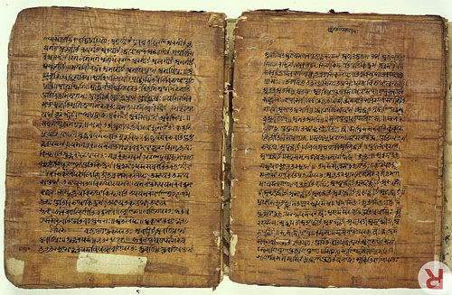
Pāṇini
A 17th-century birch bark manuscript of Pāṇini's grammar treatise from Kashmir
Notable work
Aṣṭādhyāyī (Classical Sanskrit)
Era fl. 4th century BCE;[1][2][3];
fl. 400–350 BCE[4];
6th–5th century BCE[5][6][note 1]
Region Northwest Indian subcontinent[note 2]
Pāṇini was a Sanskrit philologist, grammarian, and revered scholar in ancient India,[7][9][10] variously dated between the 6th[5][6][note 1] and 4th century BCE.[1][2][3][4]
Since the discovery and publication of his work by European scholars in the nineteenth century, Pāṇini has been considered the "first descriptive linguist",[11] and even labelled as “the father of linguistics”.[12][13][14]
Pāṇini's grammar was influential on such foundational linguists as Ferdinand de Saussure and Leonard Bloomfield.[15]
Legacy
Pāṇini is known for his text Aṣṭādhyāyī, a sutra-style treatise on Sanskrit grammar,[10][7] 3,959 verses or rules on linguistics, syntax and semantics in "eight chapters" which is the foundational text of the Vyākaraṇa branch of the Vedanga, the auxiliary scholarly disciplines of the Vedic period.[16][17][18] His aphoristic text attracted numerous bhashya (commentaries), of which Patanjali's Mahābhāṣya is the most famous in Hindu traditions.[19]His ideas influenced and attracted commentaries from scholars of other Indian religions such as Buddhism.[20]
Pāṇini's analysis of noun compounds still forms the basis of modern linguistic theories of compounding in Indian languages. Pāṇini's comprehensive and scientific theory of grammar is conventionally taken to mark the start of Classical Sanskrit.[21] His systematic treatise inspired and made Sanskrit the preeminent Indian language of learning and literature for two millennia.
Pāṇini's theory of morphological analysis was more advanced than any equivalent Western theory before the 20th century.[22] His treatise is generative and descriptive, uses metalanguage and meta-rules, and has been compared to the Turing machine wherein the logical structure of any computing device has been reduced to its essentials using an idealized mathematical model.[23]
Pāṇini likely lived in Śalatura in ancient Gandhāra in the northwest Indian subcontinent[a] during the Mahājanapada era.[25][4]
The name Pāṇini is a patronymic meaning descendant of Paṇina.[26] His full name was "Dakṣiputra Pāṇini" according to verses 1.75.13 and 3.251.12 of Patanjali's Mahābhāṣya, with the first part suggesting his mother's name was Dakṣi.[6]
Dating
Nothing definite is known about when Pāṇini lived, not even in which century he lived. Pāṇini has been dated between the seventh[27] or sixth[6] and fourth century BCE.[28][1][2][3][4][note 1] Von Hinüber (1989) based on numismatic arguments [coins] and Falk (1993) based on his Indic script studies, place him in mid-fourth century BCE.[28][1][2][3] Others use internal evidence and textual evidence in ancient Indian texts to date him in the sixth or fifth century BCE,[6] while Bod mentions the seventh to fifth century BCE.[24] George Cardona (1997) in his authoritative survey and review of Pāṇini-related studies, states that the available evidence strongly supports a dating no later than between 400 to 350 BCE, while earlier dating depends on interpretations and is not probative.[29]
According to Bod, Pāṇini's grammar defines Classical Sanskrit, so Pāṇini is chronologically placed in the later part of the Vedic period.[24] According to A. B. Keith, the Sanskrit text that most matches the language described by Pāṇini is the Aitareya Brāhmaṇa (8th-6th c. BCE).[30] According to Scharfe, "his proximity to the Vedic language as found in the Upanisads and Vedic sūtras suggests the 5th or maybe 6th c. B.C."[6]
Based on numismatic findings, Von Hinüber and Falk place Pāṇini in the mid-4th century BCE. Pāṇini's rupya (A 5.2.120) mentions a specific coin which was introduced in India in the 4th-century BCE.[3] According to Houben, "the date of "ca. 350 B.C.E. for Pāṇini is thus based on concrete evidence which till now has not been refuted."[3] According to Bronkhorst, there is no reason to doubt the validity of Von Hinüber's and Falk's argument, setting the terminus post quem[ b] for the date of Pāṇini at 350 BCE or the decades thereafter. [28] According to Bronkhorst,
Cardona mentions two major pieces of internal evidence for the dating of Pāṇini.[31] The occurrence of the word yavanānī in 4.1.49, referring to a writing (lipi) c.q. cuneiform writing, or to Greek writing, suggests a date for Pāṇini after Alexander the Great. Cardona rejects this possibility, arguing that yavanānī may also refer to a Yavana woman; and that Indians had contacts with the Greek world before Alexander's conquests.[32][note 3] Sutra 2.1.70 of Pāṇini mentions kumāraśramaṇa, derived from śramaṇa, which refers to a female renunciates, c.q. "Buddhist nuns," implying that Pāṇini should be placed after Gautama Buddha. K. B. Pathak (1930) argued that kumāraśramaṇa could also refer to a Jain nun, meaning that Pāṇini is not necessarily to be placed after the Buddha.[31]
It is not certain whether Pāṇini used writing for the composition of his work, though it is generally agreed that he knew of a form of writing, based on references to words such as lipi ("script") and lipikara ("scribe") in section 3.2 of the Aṣṭādhyāyī.[35][36][37] The dating of the introduction of writing in India may therefore give further information on the dating of Pāṇini.[note 4]
Pāṇini cites at least ten grammarians and linguists before him: Āpiśali, Kāśyapa, Gārgya, Gālava, Cākravarmaṇa, Bhāradvāja, Śākaṭāyana, Śākalya, Senaka and Sphoṭāyana.[44] According to Kamal K. Misra, Pāṇini also refers to Yaska, "whose writings date back to the middle of the 4th century B.C."[45] Both Brihatkatha and Mañjuśrī-mūla-kalpa mention Pāṇini to have been a contemporary with the Nanda king (4th c. BCE).[46]
Location
Nothing certain is known about Pāṇini's personal life. In an inscription of Siladitya VII of Valabhi, he is called Śalāturiya, which means "man from Salatura". This means Panini lived in Salatura of ancient Gandhara (present day north-west Pakistan), which likely was near Lahor, a town at the junction of Indus and Kabul rivers.[d][47][48] According to the memoirs of 7th-century Chinese scholar Xuanzang, there was a town called Suoluoduluo on the Indus where Pāṇini was born, and he composed the Qingming-lun (Sanskrit: Vyākaraṇa).[47][49][50]
According to Hartmut Scharfe, Pāṇini lived in Gandhara close to the borders of the Achaemenid Empire, and Gandhara was then an Achaemenian satrapy following the Achaemenid conquest of the Indus Valley. He must, therefore, have been technically a Persian subject but his work shows no awareness of the Persian language.[6][51] According to Patrick Olivelle, Pāṇini's text and references to him elsewhere suggest that "he was clearly a northerner, probably from the northwestern region".[52]
Legends and later reception
Panini is mentioned in Indian fables and ancient texts. The Panchatantra, for example, mentions that Pāṇini was killed by a lion.[53][54][55]
Pāṇini was depicted on a five-rupee Indian postage stamp in August, 2004.[56][57][58][59]
Aṣṭādhyāyī
Main article: Aṣṭādhyāyī
The most important of Pāṇini's works, the Aṣṭādhyāyī is a grammar that essentially defines the Sanskrit language. Modeled on the dialect and register of elite speakers in his time, the text also accounts for some features of the older Vedic language.
The Aṣtādhyāyī is a prescriptive and generative grammar with algebraic rules governing every aspect of the language. It is supplemented by three ancillary texts: akṣarasamāmnāya, dhātupāṭha[A] and gaṇapāṭha.[ b][60]
Growing out of a centuries-long effort to preserve the language of the Vedic hymns from 'corruption', the Aṣtādhyāyī is the high point of a vigorous, sophisticated grammatical tradition devised to arrest language change. The Aṣtādhyāyī's preeminence is underlined by the fact that it eclipsed all similar works that came before: while not the first, it is the oldest such text surviving in its entirety.[61][62][63][64]
The Aṣṭādhyāyī consists of 3,959 sūtras[C] in eight chapters, which are each subdivided into four sections or pādas. The text takes material from lexical lists (dhātupāṭha, gaṇapātha) as input and describes algorithms to be applied to them for the generation of well-formed words.
The Aṣṭādhyāyī, composed in an era when oral composition and transmission was the norm, is staunchly embedded in that oral tradition. In order to ensure wide dissemination, Pāṇini is said to have preferred brevity over clarity[65] - it can be recited end-to-end in two hours. This has led to the emergence of a great number of commentaries[α] of his work over the centuries, which for the most part adhere to the foundations laid by Pāṇini's work.[66][61]
Bhaṭṭikāvya
Main article: Bhaṭṭikāvya
The learning of Indian curriculum in late classical times had at its heart a system of grammatical study and linguistic analysis.[67] The core text for this study was the Aṣṭādhyāyī of Pāṇini, the sine qua non of learning.[68] This grammar of Pāṇini had been the object of intense study for the ten centuries prior to the composition of the Bhaṭṭikāvya. It was plainly Bhaṭṭi's purpose to provide a study aid to Pāṇini's text by using the examples already provided in the existing grammatical commentaries in the context of the gripping and morally improving story of the Rāmāyaṇa. To the dry bones of this grammar Bhaṭṭi has given juicy flesh in his poem. The intention of the author was to teach this advanced science through a relatively easy and pleasant medium. In his own words:
Modern linguistics
Pāṇini's work became known in 19th-century Europe, where it influenced modern linguistics initially through Franz Bopp, who mainly looked at Pāṇini. Subsequently, a wider body of work influenced Sanskrit scholars such as Ferdinand de Saussure, Leonard Bloomfield, and Roman Jakobson. Frits Staal (1930–2012) discussed the impact of Indian ideas on language in Europe. After outlining the various aspects of the contact, Staal notes that the idea of formal rules in language – proposed by Ferdinand de Saussure in 1894 and developed by Noam Chomsky in 1957 – has origins in the European exposure to the formal rules of Pāṇinian grammar.[69] In particular, de Saussure, who lectured on Sanskrit for three decades, may have been influenced by Pāṇini and Bhartrihari; his idea of the unity of signifier-signified in the sign somewhat resembles the notion of Sphoṭa. More importantly, the very idea that formal rules can be applied to areas outside of logic or mathematics may itself have been catalysed by Europe's contact with the work of Sanskrit grammarians.[69]
De Saussure
Pāṇini, and the later Indian linguist Bhartrihari, had a significant influence on many of the foundational ideas proposed by Ferdinand de Saussure, professor of Sanskrit, who is widely considered the father of modern structural linguistics and with Charles S. Peirce on the other side, to semiotics, although the concept Saussure used was semiology. Saussure himself cited Indian grammar as an influence on some of his ideas. In his Mémoire sur le système primitif des voyelles dans les langues indo-européennes (Memoir on the Original System of Vowels in the Indo-European Languages) published in 1879, he mentions Indian grammar as an influence on his idea that "reduplicated aorists represent imperfects of a verbal class." In his De l'emploi du génitif absolu en sanscrit (On the Use of the Genitive Absolute in Sanskrit) published in 1881, he specifically mentions Pāṇini as an influence on the work.[70]
Prem Singh, in his foreword to the reprint edition of the German translation of Pāṇini's Grammar in 1998, concluded that the "effect Panini's work had on Indo-European linguistics shows itself in various studies" and that a "number of seminal works come to mind," including Saussure's works and the analysis that "gave rise to the laryngeal theory," further stating: "This type of structural analysis suggests influence from Panini's analytical teaching." George Cardona, however, warns against overestimating the influence of Pāṇini on modern linguistics: "Although Saussure also refers to predecessors who had taken this Paninian rule into account, it is reasonable to conclude that he had a direct acquaintance with Panini's work. As far as I am able to discern upon rereading Saussure's Mémoire, however, it shows no direct influence of Paninian grammar. Indeed, on occasion, Saussure follows a path that is contrary to Paninian procedure."[70][71]
Leonard Bloomfield
The founding father of American structuralism, Leonard Bloomfield, wrote a 1927 paper titled "On some rules of Pāṇini".[72]
Comparison with modern formal systems
Pāṇini's grammar is the world's first formal system, developed well before the 19th century innovations of Gottlob Frege and the subsequent development of mathematical logic. In designing his grammar, Pāṇini used the method of "auxiliary symbols", in which new affixes are designated to mark syntactic categories and the control of grammatical derivations. This technique, rediscovered by the logician Emil Post, became a standard method in the design of computer programming languages.[73][74] Sanskritists now accept that Pāṇini's linguistic apparatus is well-described as an "applied" Post system. Considerable evidence shows ancient mastery of context-sensitive grammars, and a general ability to solve many complex problems. Frits Staal has written that "Panini is the Indian Euclid."
Other works
Two literary works are attributed to Pāṇini, though they are now lost.
Jāmbavati Vijaya is a lost work cited by Rajashekhara in Jalhana's Sukti Muktāvalī. A fragment is to be found in Ramayukta's commentary on Namalinganushasana. From the title it may be inferred that the work dealt with Krishna's winning of Jambavati in the underworld as his bride. Rajashekhara in Jahlana's Sukti Muktāvalī:
Ascribed to Pāṇini, Pātāla Vijaya is a lost work cited by Namisadhu in his commentary on Kavyalankara of Rudrata.
There are many mathematical works related to Pāṇini's works. Pāṇini came up with a plethora of ideas to organize the known grammatical forms of his day in a systematic way. Like any mathematician who models a known phenomenon in mathematical language, Pāṇini created a metalanguage and it is very close to the modern-day ideas of algebra. See "Mathematical Structures of Panini's Ashtaadhyayi" by Bhaskar Kompella.
See also
• Vyākaraṇa
• Bhaṭṭikāvya
• Pingala
• Mahajanapadas
• Seṭ and aniṭ roots
• Tolkappiyam
• List of Indian mathematicians
Notes
1. in what is now modern day Pakistan
2. the earliest time an event may have happened
3. Ionian
4. which falls in the Swabi District of modern Pakistan
1. 4th century BCE date:
Johannes Bronkhorst (2019): "Pāṇini's Aṣṭādhyāyī has been the target of much guesswork as to its date. Only recently have more serious proposals been made. Oskar von Hinüber (1990: 34) arrives, on the basis of a comparison of Pāṇini's text with numismatic findings, at a date that can hardly be much earlier than 350 BCE; Harry Falk (1993: 304; 1994: 327 n. 45) refines these reflections and moves the date forward to the decennia following 350 BCE. If Hinüber and Falk are right, and there seems no reason to doubt this, we have here for Pāṇini a terminus post quem.[28]
Vincenzo Vergiani (2017): "For a survey of scholarship about Panini's date see George cardona, Panini: A Survey of Research (Delhi: Motilall Banarsidass, 1980), p.260-262. Oskar von Hinüber, Der Beginn der Schrift und fruhe Schriftlichkeit in Indien (Wiesbaden: Steiner Verlag, 1989), p.34 presents evidence that suggests dating Panini to the 4th century."[1]
Johannes Bronkhorst (2016)"...thanks to the work carried out by Hinüber (1990:34-35) and Falk (1993: 303-304), we now know that Pāṇini lived, in all probability, far closer in time to the period of Asoka than had hitherto been thought. According to Falk's reasoning, Panini must have lived during the decennia following 350 BCE, i.e. just before (or contemporaneously with?) the invasion of Alexander of Macedonia."[2]
Jan E.M Houben (2009): "Pāṇini's rupya (A 5.2.120) refers to a type of coin which appeared in the Indian subcontinent only from the 4th century B.C.E. onwards: cf. von Hinüber 1989: p.34 and Falk 1993: 304. The date of "ca. 350 B.C.E. for Pāṇini is thus based on concrete evidence which till now has not been refuted."[3]
Michael Witzel (2009): "c. 350 BCE"[75]
Kamal K. Misra (2000): "But Pāṇini himself has acknowledged at least ten great Indian grammatrians before him, and one of them was Yaska, whose writings date back to the middle of the 4th century B.C."[45]
Cardona: "The evidence for dating Panini, Katyayana and Patanjali is not absolutely probative and depends on interpretation. However, I think there is one certainty, namely that the evidence available hardly allows one to date Panini later than the early to mid fourth century B. C."[4]
Harry Falk (1993), Schrift im alten Indien: ein Forschungsbericht mit Anmerkungen, Gunter Narr Verlag
Frits Staal (1965): "fourth century B.C."[76]
6th or 5th century BCE date:
Frits Staal (1996): "the Sanskrit grammar of Panini (6th or 5th century b.c.e.)"[5]
Hartmut Scharfe (1977): "Panini's date can be fixed only approximately; he must be older than Katyayana (c. 250 B.C.) who in his comments on Panini's work refers to other [stni] earlier scholars dealing with Panini's grammar; his proximity to the Vedic language as found in the Upanisads and Vedic sutra's suggests the 5th or maybe 6th c. B.C."[6] Scharfe refers to: "F. Kielhoek, GGN 1885.186f.; B. Liebich, BB 10.205-234; 11.273-315 and his book, Panini(Leipzig, 1891), p. 38-50; 0. Wecker, BB 30. 1-61+177-207; P. Thieme, Panini and the Veda(Allahabad, 1935), p. 75-81."[6]
Encyclopedia Britannica: "Ashtadhyayi, Sanskrit Aṣṭādhyāyī ("Eight Chapters"), Sanskrit treatise on grammar written in the 6th to 5th century BCE by the Indian grammarian Panini."
7th to 5th century BCE date
Rens Bod (2013): "All we know is that he was born in Ghandara, in former India (currently Afghanistan), and that it must have been between the seventh and fifth centuries BCE."[27] Bod refers to "S. Shukla, 'Panini', Encyclopedia of Language & Linguistics, 2nd edition, Elsevier, 2006. See also Paul Kiparsky, 'Paninian Linguistics', Encyclopedia of Language and Linguistics, 1st edition, Elsevier, 1993."[77]
2. According to George Cardonna, the tradition believes that Pāṇini came from Salatura in northwest part of the Indian subcontinent.[4] This is likely to be ancient Gandhara.[7]
3. In 1862 Max Müller argued that yavana may have meant "Greek"[c] during Pāṇinis time, but may also refer to Semitic or dark-skinned Indian people.[33][34]
4. Pāṇini's use of the term lipi has been a source of scholarly disagreements. Harry Falk in his 1993 overview states that ancient Indians neither knew nor used writing script, and Pāṇini's mention is likely a reference to Semitic and Greek scripts.[38] In his 1995 review, Salomon questions Falk's arguments and writes it is "speculative at best and hardly constitutes firm grounds for a late date for Kharoṣṭhī. The stronger argument for this position is that we have no specimen of the script before the time of Aśoka, nor any direct evidence of intermediate stages in its development; but of course this does not mean that such earlier forms did not exist, only that, if they did exist, they have not survived, presumably because they were not employed for monumental purposes before Aśoka".[39] According to Hartmut Scharfe, Lipi of Pāṇini may be borrowed from the Old Persian Dipi, in turn derived from Sumerian Dup. Scharfe adds that the best evidence, at the time of his review, is that no script was used in India, aside from the Northwest Indian subcontinent, before around 300 BCE because Indian tradition "at every occasion stresses the orality of the cultural and literary heritage."[40] Kenneth Norman states writing scripts in ancient India evolved over the long period of time like other cultures, that it is unlikely that ancient Indians developed a single complete writing system at one and the same time in the Maurya era. It is even less likely, states Norman, that a writing script was invented during Ashoka's rule, starting from nothing, for the specific purpose of writing his inscriptions and then it was understood all over South Asia where the Aśoka pillars are found.[41] Jack Goody states that ancient India likely had a "very old culture of writing" along with its oral tradition of composing and transmitting knowledge, because the Vedic literature is too vast, consistent and complex to have been entirely created, memorized, accurately preserved and spread without a written system.[42] Falk disagrees with Goody, and suggests that it is a Western presumption and inability to imagine that remarkably early scientific achievements such as Pāṇini's grammar (5th to 4th century BCE), and the creation, preservation and wide distribution of the large corpus of the Brahmanic Vedic literature and the Buddhist canonical literature, without any writing scripts. Johannes Bronkhorst disagrees with Falk, and states, "Falk goes too far. It is fair to expect that we believe that Vedic memorisation — though without parallel in any other human society — has been able to preserve very long texts for many centuries without losing a syllable. (...) However, the oral composition of a work as complex as Pāṇini's grammar is not only without parallel in other human cultures, it is without parallel in India itself. (...) It just will not do to state that our difficulty in conceiving any such thing is our problem".[43]
Glossary
1. dhātu: root, pāṭha: reading, lesson
2. gaṇa: class
3. aphoristic threads
Traditional glossary and notes
1. bhāṣyas
References
1. Vergiani 2017, p. 243, n.4.
2. Bronkhorst 2016, p. 171.
3. Houben 2009, p. 6.
4. Cardona 1997, p. 268.
5. Staal 1996, p. 39.
6. Scharfe 1977, p. 88.
7. Staal 1965.
8. Staal 1972, p. xi.
9. Lidova 1994, p. 108-112.
10. Lochtefeld 2002a, p. 64–65, 140, 402.
11. François & Ponsonnet (2013: 184).
12. Bod 2013, p. 14-19.
13. Patañjali; Ballantyne, James Robert; Kaiyaṭa; Nāgeśabhaṭṭa (1855). Mahābhāṣya …. Mirzapore. OCLC 47644586.
14. Pāṇini; Boehtlingk, Otto von (1886). Panini's Grammatik, herausgegeben, übersetzt, erläutert… von O. Böhtlingk. Sansk. and Germ. Leipzig. OCLC 562865694.
15. Henry), Robins, R. H. (Robert (1997). A short history of linguistics (4th ed.). London: Longman. ISBN 0582249945. OCLC 35178602.
16. W. J. Johnson (2009), A Dictionary of Hinduism, Oxford University Press, ISBN 978-0198610250, article on Vyakarana
17. Harold G. Coward 1990, p. 105.
18. Lisa Mitchell (2009). Language, Emotion, and Politics in South India. Indiana University Press. p. 108. ISBN 978-0-253-35301-6.
19. James G. Lochtefeld (2002). The Illustrated Encyclopedia of Hinduism: N-Z. The Rosen Publishing Group. p. 497. ISBN 978-0-8239-3180-4.
20. Hartmut Scharfe (1977). Grammatical Literature. Otto Harrassowitz Verlag. pp. 152–154. ISBN 978-3-447-01706-0.
21. Yuji Kawaguchi; Makoto Minegishi; Wolfgang Viereck (2011). Corpus-based Analysis and Diachronic Linguistics. John Benjamins Publishing Company. pp. 223–224. ISBN 978-90-272-7215-7.
22. Staal, Frits (1988). Universals: studies in Indian logic and linguistics. University of Chicago Press. p. 47. ISBN 9780226769998.
23. Kak, Subhash C. (January 1987). "The Paninian approach to natural language processing". International Journal of Approximate Reasoning. 1 (1): 117–130. doi:10.1016/0888-613X(87)90007-7.
24. Bod 2013, p. 14-18.
25. Avari, Burjor (2007). India: The Ancient Past: A History of the Indian Sub-Continent from c. 7000 BC to AD 1200. Routledge. p. 156. ISBN 978-1-134-25161-2.
26. Pāṇini; Sumitra Mangesh Katre (1989). Aṣṭādhyāyī of Pāṇini. Motilal Banarsidass. p. xx. ISBN 978-81-208-0521-7.
27. Bod 2013, p. 14.
28. Bronkhorst 2019.
29. Cardona 1997, pp. 261–268; Quote: ".
30. Keith, Arthur Berriedale (1998). Rigveda Brahmanas: the Aitareya and Kauṣītaki Brāhmaṇas of the Rigveda. Delhi: Motilal Banarsidass. ISBN 978-8120813595. OCLC 611413511.
31. Cardona 1997, p. 261-262.
32. Cardona 1997, p. 261.
33. Max Müller (1862). On Ancient Hindu Astronomy and Chronology. Oxford. pp. footnotes of 69–71. Bibcode:1862ahac.book.....M.
34. Patrick Olivelle (1999). Dharmasutras. Oxford University Press. p. xxxii with footnote 13. ISBN 978-0-19-283882-7.
35. Richard Salomon (1998). Indian Epigraphy: A Guide to the Study of Inscriptions in Sanskrit, Prakrit, and the other Indo-Aryan Languages. Oxford University Press. p. 11. ISBN 978-0-19-535666-3.
36. Juhyung Rhi (2009). "On the Peripheries of Civilizations: The Evolution of a Visual Tradition in Gandhāra". Journal of Central Eurasian Studies. 1: 5, 1–13.
37. Rita Sherma; Arvind Sharma (2008). Hermeneutics and Hindu Thought: Toward a Fusion of Horizons. Springer. p. 235. ISBN 978-1-4020-8192-7.
38. Falk, Harry (1993). Schrift im alten Indien: ein Forschungsbericht mit Anmerkungen (in German). Gunter Narr Verlag. pp. 109–167.
39. Salomon, Richard (1995). "Review: On the Origin of the Early Indian Scripts". Journal of the American Oriental Society. 115 (2): 271–278. doi:10.2307/604670. JSTOR 604670.
40. Scharfe, Hartmut (2002), Education in Ancient India, Handbook of Oriental Studies, Leiden, Netherlands: Brill, pp. 10–12
41. Oskar von Hinüber (1989). Der Beginn der Schrift und frühe Schriftlichkeit in Indien. Akademie der Wissenschaften und der Literatur. pp. 241–245. ISBN 9783515056274. OCLC 22195130.
42. Jack Goody (1987). The Interface Between the Written and the Oral. Cambridge University Press. pp. 110–124. ISBN 978-0-521-33794-6.
43. Johannes Bronkhorst (2002), Literacy and Rationality in Ancient India, Asiatische Studien / Études Asiatiques, 56(4), pages 803-804, 797-831
44. Cardona 1997, §1.3.
45. Misra 2000, p. 49.
46. [A History of Ancient and Early Medieval India: From the Stone Age to the 12th Century, Upinder Singh, Pearson Education India, 2008 p. 258]
47. Hartmut Scharfe (1977). Grammatical Literature. Otto Harrassowitz Verlag. pp. 88 with footnotes. ISBN 978-3-447-01706-0.
48. Saroja Bhate, Panini, Sahitya Akademi (2002), p. 4
49. Singh, Nagendra Kr., ed. (1997), Encyclopaedia of Hinduism, New Delhi: Centre for International Religious Studies : Anmol Publications, pp. 1983–2007, ISBN 978-81-7488-168-7
50. Mishra, Giridhar (1981). "प्रस्तावना" [Introduction]. अध्यात्मरामायणेऽपाणिनीयप्रयोगाणां विमर्शः[Deliberation on non-Paninian usages in the Adhyatma Ramayana] (in Sanskrit). Varanasi, India: Sampurnanand Sanskrit University. Retrieved 21 May 2013.
51. Lal, Shyam Bihari (2004). "Yavanas in the Ancient Indian Inscriptions". Proceedings of the Indian History Congress. 65: 1115–1120. ISSN 2249-1937. JSTOR 44144820.
52. Patrick Olivelle (1999). Dharmasutras. Oxford University Press. pp. xxvi–xxvii. ISBN 978-0-19-283882-7.
53. George Cardona (1997). Pāṇini: a survey of research. The verse reads siṃho vyākaraṇasya kartur aharat prāṇān priyān pāṇineḥ "a lion took the dear life of Panini, author of the grammatical treatise". The context is a list of scholars killed by animals, siṃho vyākaraṇasya kartur aharat prāṇān priyān pāṇineḥ / mīmāṃsākṛtam unmamātha sahasā hastī muniṃ jaiminim // chandojnānanidhim jaghāna makaro velātaṭe piṅgalam / ajñānāvṛtacetasām atiruṣāṃ ko'rthas tiraścām guṇaiḥ // Translation: "A lion killed Pāṇini; an elephant madly crushed the sage Jaimini, Mimamsa's author; Pingala, treasury of knowledge of poetic meter, was killed by a crocodile at the water's edge. What do senseless beasts, overcome with fury, care for intellectual virtues?" (Pañcatantra II.28, sometimes ascribed to Vallabhadeva)
54. Bhattacharyya, D. C. (1928). "Date of the Subhasitavali". Journal of the Royal Asiatic Society of Great Britain and Ireland. 60 (1): 135–137. doi:10.1017/S0035869X00059773. JSTOR 25221320.
55. Winternitz, Moriz (1963). History of Indian Literature. Motilal Banarsidass. p. 462. ISBN 978-81-208-0056-4.; Nakamura, Hajime (1983). A History of Early Vedānta Philosophy. Motilal Banarsidass. p. 400. ISBN 978-81-208-0651-1.
56. "Stamps 2004". Indian Department of Posts, Ministry of Communications & Information Technology. 23 April 2015. Retrieved 3 June 2015.
57. "Panini". http://www.istampgallery.com. Retrieved 11 December 2018.
58. Academy, Himalayan. "Hinduism Today Magazine". http://www.hinduismtoday.com. Retrieved 11 December 2018.
59. "India Postage Stamp on Panini issued on 01 Aug 2004". http://www.getpincodes.com. Retrieved 11 December 2018.
60. Cardona, §1-3.
61. Burrow, §2.1.
62. Coulson, p. xv.
63. Whitney, p. xii.
64. Cardona, §4.
65. Whitney, p. xiii
66. Coulson, p xvi.
67. Filliozat. 2002 The Sanskrit Language: An Overview – History and Structure, Linguistic and Philosophical Representations, Uses and Users. Indica Books.
68. Fallon, Oliver. 2009. Bhatti's Poem: The Death of Rávana (Bhaṭṭikāvya). New York: Clay Sanskrit Library[1]. ISBN 978-0-8147-2778-2 | ISBN 0-8147-2778-6 |
69. Frits Staal, The science of language, Chapter 16, in Gavin D. Flood, ed. The Blackwell Companion to Hinduism Blackwell Publishing, 2003, 599 pages ISBN 0-631-21535-2, ISBN 978-0-631-21535-6. p. 357-358
70. George Cardona (2000), "Book review: Pâṇinis Grammatik", Journal of the American Oriental Society, 120 (3): 464–5, JSTOR 606023
71. D'Ottavi, Giuseppe (2013). "Paṇini et le Mémoire". Arena Romanistica. 12: 164–193. (reprinted in "De l'essence double du langage" et le renouveau du saussurisme. 2016.).
72. Leonard Bloomfield (1927). On some rules of Pāṇini. Journal of the American Oriental Society. 47. American Oriental Society. pp. 61–70. doi:10.2307/593241. ISBN 9780226060712. JSTOR 593241.
73. Bhate, S. and Kak, S. (1993) Panini and Computer Science. Annals of the Bhandarkar Oriental Research Institute, vol. 72, pp. 79-94.
74. Kadvany, John (2007), "Positional Value and Linguistic Recursion", Journal of Indian Philosophy, 35 (5–6): 487–520, CiteSeerX 10.1.1.565.2083, doi:10.1007/s10781-007-9025-5, S2CID 52885600.
75. Witzel 2009.
76. Staal 1965, p. 99.
77. Bod 2013, p. 14, n.2.
Bibliography
• Bhate, S. and Kak, S. (1993) Panini and Computer Science. Annals of the Bhandarkar Oriental Research Institute, vol. 72, pp. 79–94.
• Bod, Rens (2013), A New History of the Humanities: The Search for Principles and Patterns from Antiquity to the Present, Oxford University Press, ISBN 978-0-19-966521-1
• Bronkhorst, Johannes (2016), How the Brahmins Won: From Alexander to the Guptas, BRILL, ISBN 9789004315518
• Bronkhorst, Johannes (2019), A Śabda Reader: Language in Classical Indian Thought, Columbia University Press, ISBN 9780231548311
• Cardona, George (1997) [1976], Pāṇini: A Survey of Research, Motilal Banarsidass, ISBN 978-81-208-1494-3
• Harold G. Coward (1990). The Philosophy of the Grammarians, in Encyclopedia of Indian Philosophies Volume 5 (Editor: Karl Potter). Princeton University Press. ISBN 978-81-208-0426-5.
• Carter, George F.; et al. (1979). "On Mundkur on Diffusion". Current Anthropology. 20 (2): 425–428. doi:10.1086/202297. S2CID 143783458.
• François, Alexandre; Ponsonnet, Maïa (2013). "Descriptive linguistics" (PDF). In Jon R. McGee; Richard L. Warms (eds.). Theory in Social and Cultural Anthropology: An Encyclopedia. 1. SAGE Publications, Inc. pp. 184–187. ISBN 9781412999632.
• Ingerman, Peter Zilahy (March 1967). ""Pāṇini-Backus Form" Suggested". Communications of the ACM. 10 (3): 137. doi:10.1145/363162.363165. S2CID 52817672. Ingerman suggests that the then-called Backus normal form be renamed to the Pāṇini–Backus form, to give due credit to Pāṇini as the earliest independent inventor.
• Kadvany, John (8 February 2008). "Positional Value and Linguistic Recursion". Journal of Indian Philosophy. 35 (5–6): 487–520. CiteSeerX 10.1.1.565.2083. doi:10.1007/s10781-007-9025-5. S2CID 52885600.
• Tibor Kiss (2015). Syntax - Theory and Analysis. Walter de Gruyter. ISBN 978-3-11-037740-8.
• Lidova, Natalia (1994), Drama and Ritual of Early Hinduism, Motilal Banarsidass, ISBN 978-81-208-1234-5
• Locjtfeld, James G. (2002a), The Illustrated Encyclopedia of Hinduism: A-M, The Rosen Publishing Group, ISBN 978-0-8239-3179-8
• Misra, Kamal K. (2000), Textbook of Anthropological Linguistics, Concept Publishing Company
• Prince, Alan; Smolensky, Paul (15 April 2008). Optimality Theory: Constraint Interaction in Generative Grammar. John Wiley & Sons. ISBN 978-0-470-75939-4.
• T. R. N. Rao. Pāṇini-backus form of languages. 1998.
• Scharfe, Hartmut (1977), Grammatical Literature, Otto Harrassowitz Verlag, ISBN 978-3-447-01706-0
• Staal, Frits (April 1965), "Euclid and Pāṇini", Philosophy East and West, 15 (2): 99–116, doi:10.2307/1397332, JSTOR 1397332
• Staal, Frits (1972). A Reader on the Sanskrit Grammarians. MIT Press. ISBN 0-262-19078-8.
• Staal, Frits (1996), Ritual and Mantras: Rules Without Meaning, Motilal Banarsidass, ISBN 978-8120814127
• Tiwary, Kapil Muni 1968 Pāṇini's description of nominal compounds, University of Pennsylvania doctoral dissertation, unpublished.
• Vergiani, Vincenzo (2017), "Bhartrhari on Language, Perception, and Consciousness", in Ganeri, Jonardon (ed.), The Oxford Handbook of Indian Philosophy, Oxford University Press, ISBN 9780199314638
• Witzel, Michael (2009), "Moving Targets? Texts, language, archaeology and history in the Late Vedic and early Buddhist periods", Indo-Iranian Journal, 52 (2–3): 287–310, doi:10.1163/001972409X12562030836859
Further reading[edit]
Works
• Pāṇini. Ashtādhyāyī. Book 4. Translated by Chandra Vasu. Benares, 1896. (in Sanskrit and English)
• Pāṇini. Ashtādhyāyī. Book 6–8. Translated by Chandra Vasu. Benares, 1897. (in Sanskrit and English)
Pāṇini
• O'Connor, John J.; Robertson, Edmund F., "Pāṇini", MacTutor History of Mathematics archive, University of St Andrews 2000.
• Pāṇini - His work and its traditions, George Cardona. 1997. (in English)
External links
• PaSSim – Paninian Sanskrit Simulator simulates the Pāṇinian Process of word formation
• The system of Panini
• Gaṇakāṣṭādhyāyī, a software on Sanskrit grammar, based on Pāṇini's Sutras
• Ashtadhyayi, Work by Pāṇini
• Forizs, L. Pāṇini, Nāgārjuna and Whitehead – The Relevance of Whitehead for Contemporary Buddhist Philosophy
• The Aṣṭādhyāyī of Pāṇini, with the Mahābhāṣya and Kāśikā commentaries, along with the Nyāsa and Padamanjara commentaries on the Kāśikā. (PDF) Sanskrit.
• Pāṇinian Linguistics
********************************
Aṣṭādhyāyī
by Wikipedia
Accessed: 9/3/21
The Aṣṭādhyāyī (Devanagari: अष्टाध्यायी) is a grammar that describes a form of early Indo-Aryan: Sanskrit. Authored by Sanskrit philologist and scholar Pāṇini and dated to around 500 BCE, it describes the language as current in his time, specifically the dialect and register of an élite of model speakers, referred to by Pāṇini himself as śiṣṭa. The work also accounts both for some features specific to the older Vedic form of the language, as well as certain dialectal features current in the author's time.
The Aṣṭādhyāyī employs a derivational system to describe the language, where real speech is derived from posited abstract utterances formed by means of affixes added to bases under certain conditions.
The Aṣṭādhyāyī is supplemented by three ancillary texts: akṣarasamāmnāya, dhātupāṭha[A] and gaṇapāṭha.[ b][1]
Etymology
Aṣṭādhyāyī is made of two words aṣta-, 'eight' and adhyāya-, 'chapter', thus meaning eight-chaptered, or 'the book of eight chapters'.[2]
Background
Grammatical tradition
By 1000 BCE, a large body of hymns composed in the oldest attested form of the Proto-Indo-Aryan language had been consolidated into the Ṛg·Veda, which formed the canonical basis of the Vedic religion, being transmitted from generation to generation entirely orally.
In the course of the following centuries, as the popular speech evolved, growing concern among the guardians of the Vedic religion that the hymns be passed on without 'corruption' led to the rise of a vigorous, sophisticated grammatical tradition involving the study of linguistic analysis, in particular phonetics alongside grammar. The high point of this centuries-long endeavor was Pāṇini's Aṣṭādhyāyī, which eclipsed all others before him.[3][4][5]
While not the first, the Aṣtādhyāyī is the oldest linguistic and grammar text, and one of the oldest Sanskrit texts, surviving in its entirety. Pāṇini refers to older texts such as the Unādisūtra, Dhātupāṭha, and Gaṇapātha but some of these have only survived in part.[6]
Arrangement
The Aṣṭādhyāyī consists of 3,959 sūtras[C] in eight chapters, which are each subdivided into four sections or pādas. There are different types of sūtras, with the vidhisūtra - operational rules, being the main one. The other, ancillary sūtras, are:[7]
• paribhāṣā - metarules
• adhikāra - headings
• atideśa•sūtra - extension rules
• niyama•sūtra - restrictive rules
• pratiṣedha- & niṣedha•sūtra - negation rules
Related fields
The Aṣṭādhyāyī is the foundation of Vyākaraṇa, one of the Vedic ancillary fields (Vedāṅgas),[8] and complements others such as the Niruktas, Nighaṇṭus, and Śikṣā.[9] Regarded as extremely compact without sacrificing completeness, it would become the model for later specialist technical texts or sūtras.[10]
Method
The text takes material from lexical lists (dhātupāṭha, gaṇapātha) as input and describes algorithms to be applied to them for the generation of well-formed words. It is highly systematised and technical. Inherent in its approach are the concepts of the phoneme, the morpheme and the root.[a] A consequence of his grammar's focus on brevity is its highly unintuitive structure, reminiscent of modern notations such as the "Backus–Naur form".[citation needed] His sophisticated logical rules and technique have been widely influential in ancient and modern linguistics.
Pāṇini makes use of a technical metalanguage consisting of a syntax, morphology, and lexicon. This metalanguage is organised according to a series of meta-rules, some of which are explicitly stated while others can be deduced.[12][ b]
Commentarial tradition
The Aṣṭādhyāyī, composed in an era when oral composition and transmission was the norm, is staunchly embedded in that oral tradition. In order to ensure wide dissemination, Pāṇini is said to have preferred brevity over clarity[14] - it can be recited end-to-end in two hours. This has led to the emergence of a great number of commentaries[α] of his work over the centuries, which for the most part adhere to the foundations laid by Pāṇini's work.[15][3]
The most famous and among the most ancient of these Bhāṣyas is the Mahābhāṣya[c][16] of Patañjali.[17][18][d][e][f] Non-Hindu texts and traditions on grammar emerged after Patañjali, some of which include the Sanskrit grammar text of Jainendra of Jainism and the Chandra school of Buddhism.
Critical responses
In the Aṣṭādhyāyī, language is observed in a manner that has no parallel among Greek or Latin grammarians. Pāṇini's grammar, according to Renou and Filliozat, defines the linguistic expression and a classic that set the standard for Sanskrit language.[20]
Rules
The first two sutras are as follows:
In these sutras, the letters which here are put into the upper case actually are special meta-linguistic symbols; they are called IT [iii] markers or, by later writers such as Katyayana and Patanjali, anubandhas (see below). The C and Ṅ refer to Shiva Sutras 4 ("ai, au, C") and 3 ("e, o, Ṅ"), respectively, forming what are known as the pratyāhāras "comprehensive designations" aiC, eṄ. They denote the list of phonemes {ai, au} and {e, o} respectively. The T [iv] appearing (in its variant form /d/) in both sutras is also an IT marker: Sutra 1.1.70 defines it as indicating that the preceding phoneme does not represent a list, but a single phoneme, encompassing all supra-segmental features such as accent and nasality. For further example, āT[v] and aT[vi] represent ā[vii] and a[viii] respectively.
When a sutra defines the technical term, the term defined comes at the end, so the first sutra should have properly been ādaiJ vṛddhir instead of vṛddhir ādaiC. However the orders are reversed to have a good-luck word at the very beginning of the work; vṛddhir happens to mean 'prosperity' in its non-technical use.
Thus the two sūtras consist of a list of phonemes, followed by a technical term; the final interpretation of the two sūtras above is thus:
At this point, one can see they are definitions of terminology: guṇa and vṛ́ddhi are the terms for the full and the lengthened Indo-European ablaut grades, respectively.
List of IT markers
its or anubandhas are defined in P. 1.3.2 through P. 1.3.8. These definitions refer only to items taught in the grammar or its ancillary texts such at the dhātupāţha; this fact is made clear in P. 1.3.2 by the word upadeśe, which is then continued in the following six rules by anuvṛtti, Ellipsis. As these anubandhas are metalinguistic markers and not pronounced in the final derived form, pada (word), they are elided by P. 1.3.9 tasya lopaḥ – 'There is elision of that (i.e. any of the preceding items which have been defined as an it).' Accordingly, Pāṇini defines the anubandhas as follows:
1. Nasalized vowels, e.g. bhañjO. Cf. P. 1.3.2.
2. A final consonant (haL). Cf. P. 1.3.3.
2. (a) except a dental, m and s in verbal or nominal endings. Cf. P. 1.3.4.
3. Initial ñi ṭu ḍu. Cf. P 1.3.5
4. Initial ṣ of a suffix (pratyaya). Cf. P. 1.3.6.
5. Initial palatals and cerebrals of a suffix. Cf. P. 1.3.7
6. Initial l, ś, and velars but not in a taddhita 'secondary' suffix. Cf. P. 1.3.8.
A few examples of elements that contain its are as follows:
• suP nominal suffix
• Ś-IT
o Śi strong case endings
o Ślu elision
o ŚaP active marker
• P-IT
o luP elision
o āP ā-stems
CāP
ṬāP
ḌāP
o LyaP (7.1.37)
• L-IT
• K-IT
o Ktvā
o luK elision
• saN Desiderative
• C-IT
• M-IT
• Ṅ-IT
o Ṅí Causative
o Ṅii ī-stems
ṄīP
ṄīN
Ṅī'Ṣ
o tiṄ verbal suffix
o lUṄ Aorist
o lIṄ Precative
• S-IT
• GHU class of verbal stems (1.1.20)
• GHI (1.4.7)
Auxiliary texts
Pāṇini's Ashtadhyayi has three associated texts.
• The Shiva Sutras are a brief but highly organised list of phonemes.
• The Dhatupatha is a lexical list of verbal roots sorted by present class.
• The Ganapatha is a lexical list of nominal stems grouped by common properties.
Main article: Śiva Sūtras
The Śiva Sūtras describe a phonemic notational system in the fourteen initial lines preceding the Aştādhyāyī. The notational system introduces different clusters of phonemes that serve special roles in the morphology of Sanskrit, and are referred to throughout the text. Each cluster, called a pratyāhāra ends with a dummy sound called an anubandha (the so-called IT index), which acts as a symbolic referent for the list. Within the main text, these clusters, referred through the anubandhas, are related to various grammatical functions.
Dhātupāțha
The Dhātupāțha is a lexicon of Sanskrit verbal roots subservient to the Aștādhyāyī. It is organised by the ten present classes of Sanskrit, i.e. the roots are grouped by the form of their stem in the present tense.
The ten present classes of Sanskrit are:
1. bhū•ādayaḥ (root-full grade thematic presents)
2. ad•ādayaḥ (root presents)
3. juhoty•ādayaḥ (reduplicated presents)
4. div•ādayaḥ (ya thematic presents)
5. su•ādayaḥ (nu presents)
6. tud•ādayaḥ (root-zero grade thematic presents)
7. rudh•ādayaḥ (n-infix presents)
8. tan•ādayaḥ (no presents)
9. krī•ādayaḥ (ni presents)
10. cur•ādayaḥ (aya presents, causatives)
The small number of class 8 verbs are a secondary group derived from class 5 roots, and class 10 is a special case, in that any verb can form class 10 presents, then assuming causative meaning. The roots specifically listed as belonging to class 10 are those for which any other form has fallen out of use (causative deponents, so to speak).
This lexicon lists all the verbal roots (dhatu) of Sanskrit, indicating their properties and meanings in Sanskrit. There are approximately 2300 roots in Dhatupatha. Of these, 522 roots are often used in classical Sanskrit.
There are other similar descriptions of the roots of Sanskrit and commentaries to them, for example: “Dhatuparayana»Dhātupārāyaṇa. And also, there are "Dhatupathis" by other authors, but with the same meaning: descriptions of the roots of Sanskrit.
Dhatu-patha is divided into two parts, in the second part - the content and an alphabetical list of all roots. In the first part, the roots are located along the ghana. Within the ghana, roots are sorted by endings and by their behavior during word formation and conjugation (roots with similar behavior are grouped into one section). Many roots in Dhatupatha were introduced along with anubadhas (anubandha is a letter that is not part of the root, but indicates some kind of rule, similar to the modern function of hyperlinks).
Gaņapāțha
The Gaņapāțha is a list of groups of primitive nominal stems used by the Aștâdhyāyī.
Examples of groups include:
1. Listing of verbal prefixes (upasargas).
2. Listing of "pronouns" - this is not really an accurate translation but is commonly used as the list includes 'he', 'she', 'it', but also 'all' (from which the group gets its name), 'that'... Correct name is sarvaņāman.
Commentary
After Pāṇini, the Mahābhāṣya of Patañjali on the Aṣṭādhyāyī is one of the three most famous works in Sanskrit grammar. It was with Patañjali that Indian linguistic science reached its definite form. The system thus established is extremely detailed as to Śikṣā (phonology, including accent) and vyākaraṇa (morphology). Syntax is scarcely touched, but nirukta (etymology) is discussed, and these etymologies naturally lead to semantic explanations. People interpret his work to be a defence of Pāṇini, whose Sūtras are elaborated meaningfully. He also attacks Kātyāyana rather severely. But the main contributions of Patañjali lies in the treatment of the principles of grammar enunciated by him.
Other information
Pāṇini's work has been one of the important sources of cultural, religious, and geographical information about ancient India, with he himself being referred to as a Hindu scholar of grammar and linguistics.[21][22][23] His work, for example, illustrates the word Vasudeva (4.3.98) as a proper noun in an honorific sense, that can equally mean a divine or an ordinary person. This has been interpreted by scholars as attesting the significance of god Vasudeva (Krishna) or the opposite.[24] The concept of dharma is attested in his sutra 4.4.41 as, dharmam carati or "he observes dharma (duty, righteousness)" (cf. Taittiriya Upanishad 1.11).[25][26] Much social, geographical and historical information has been thus inferred from a close reading of Pāṇini's grammar.[27]
Editions
• Rama Nath Sharma, The Aṣṭādhyāyī of Pāṇini (6 Vols.), 2001, ISBN 8121500516[28]
• Otto Böhtlingk, Panini's Grammatik 1887, reprint 1998 ISBN 3-87548-198-4
• Katre, Sumitra M., Astadhyayi of Panini, Austin: University of Texas Press, 1987. Reprint Delhi: Motilal Banarsidass, 1989. ISBN 0-292-70394-5
• Misra, Vidya Niwas, The Descriptive Technique of Panini, Mouton and Co., 1966.
• Vasu, Srisa Chandra, The Ashṭádhyáyí of Páṇini. Translated into English, Indian Press, Allahabad, 1898.[29]
Notes
1. His rules have a reputation for perfection[11] – that is, they tersely describe Sanskrit morphology unambiguously and completely.
2. "Udayana states that a technical treatise or śāstra, in any discipline, should aspire to clarity (vaiśadya), compactness (laghutā), and completeness (kṛtsnatā). A compilation of sūtras maximises compactness and completeness, at the expense of clarity. A bhāṣya is complete and clear, but not compact. A group of sūtras, a 'section' or prakaraṇa of the whole compilation, is clear and compact, but not complete. The sūtras achieve compactness i) by making sequence significant, ii) letting one item stand for or range over many, and iii) using grammar and lexicon artificially. The background model is always Pāṇini's grammar for the Sanskrit language, the Aṣṭādhyāyī, which exploits a range of brevity-enabling devices to compose what has often been described as the tersest and yet most complete grammar of any language." The monumental multi-volume grammars published in the 20th century (for Sanskrit, the Altindische Grammatik 1896–1957) of course set new standards in completeness, but the Aṣṭādhyāyī remains unrivalled in terms of terseness.[13]
3. great commentary
4. Patañjali may or may not be the same person as the one who authored Yogasūtras
5. The Mahābhāṣya is more than a commentary on Aṣṭādhyāyī. It is the earliest known philosophical text of the Hindu Grammarians.
6. The earliest secondary literature on the primary text of Pāṇini are by Kātyāyana (~3rd century BCE) and Patanjali (~2nd century BCE).[19]
Glossary
1. dhātu: root, pāṭha: reading, lesson
2. gaṇa: class
3. aphoristic threads
Traditional glossary and notes
1. bhāṣyas
References
1. Cardona, §1-3.
2. Monier Monier-Williams
3. Jump up to:a b Burrow, §2.1.
4. Coulson, p. xv.
5. Whitney, p. xii.
6. Cardona, §4.
7. Cardona (1997) §10.
8. Harold G. Coward 1990, pp. 13-14, 111.
9. James Lochtefeld (2002), "Vyākaraṇa" in The Illustrated Encyclopedia of Hinduism, Vol. 2: N-Z, Rosen Publishing, ISBN 0-8239-2287-1, pages 476, 744-745, 769
10. Jonardon Ganeri, Sanskrit Philosophical Commentary (PDF)
11. Bloomfield, L., 1929, "Review of Liebich, Konkordanz Pāṇini-Candra," Language 5, 267–276.
12. Angot, Michel. L'Inde Classique, pp.213–215. Les Belles Lettres, Paris, 2001. ISBN 2-251-41015-5
13. In the 1909 Imperial Gazetteer of India, it was still possible to describe it as "at once the shortest and the fullest grammar in the world". Sanskrit Literature, The Imperial Gazetteer of India, vol. 2 (1909), p. 263.
14. Whitney, p. xiii
15. Coulson, p xvi.
16. George Cardona 1997, pp. 243-259.
17. Harold G. Coward 1990, p. 16.
18. Harold G. Coward 1990, pp. 16-17.
19. Tibor Kiss 2015, pp. 71-72.
20. Louis Renou & Jean Filliozat. L'Inde Classique, manuel des etudes indiennes, vol.II pp.86–90, École française d'Extrême-Orient, 1953, reprinted 2000. ISBN 2-85539-903-3.
21. Steven Weisler; Slavoljub P. Milekic (2000). Theory of Language. MIT Press. p. 44. ISBN 978-0-262-73125-6., Quote:"The linguistic investigations of Panini, the notable Hindu grammarian, can be ..."
22. Morris Halle (1971). The Sound Pattern of Russian: A Linguistic and Acoustical Investigation. Walter de Gruyter. p. 88. ISBN 978-3-11-086945-3., Quote: "The problem was, however, faced by the Hindu grammarian Panini, who apparently was conscious of the grammatical implications of his phonetic classificatory scheme."
23. John Bowman (2005). Columbia Chronologies of Asian History and Culture. Columbia University Press. pp. 728 (Panini, Hindu grammarian, 328). ISBN 978-0-231-50004-3.
24. R. G. Bhandarkar (1910), Vasudeva of Panini IV, iii, 98, The Journal of the Royal Asiatic Society of Great Britain and Ireland, Cambridge University Press, (Jan., 1910), pp. 168-170
25. Rama Nath Sharma (1999). The Aṣṭādhyāyī of Pāṇini: English translation of adhyāyas four and five. Munshiram Manoharlal. p. 377. ISBN 978-81-215-0747-9.
26. Peter Scharf (2014). Ramopakhyana - The Story of Rama in the Mahabharata. Routledge. p. 192. ISBN 978-1-136-84655-7.
27. VĀSUDEVA S. AGARVĀLĀ (1963). India as known to Pāṇini. A study of the cultural material in the Ashṭādhyāyī. (Radha Kumud Mookerji Endowment Lectures for 1952.) [With a plate and folding maps.] Varanasi. OCLC 504674962.
28. "The Astadhyayi of Panini (6 Vols.) by Rama Nath Sharma at Vedic Books". http://www.vedicbooks.net. Retrieved 2016-09-22.
29. Books I, III, IV, V, VI, VII, VIII.
Bibliography
• Cardona, George (1997). Pāṇini - His Work and its Traditions - Vol 1 (2nd ed.). Motilal Banarsidass. ISBN 81-208-0419-8.
• Fortson, Benjamin W. Indo-European Language and Culture (2010 ed.). Wiley-Blackwell. ISBN 978-1-4051-8895-1.
• Burrow, T. The Sanskrit Language (2001 ed.). Motilal Banarsidass. ISBN 81-208-1767-2.
• Whitney, William Dwight. Sanskrit Grammar (2000 ed.). Motilal Banarsidass. ISBN 81-208-0620-4.
• Macdonnel, Arthur Anthony. A Sanskrit Grammar for Students. Motilal Banarsidass. ISBN 81-246-0094-5.
• Kale, M R. A Higher Sanskrit Grammar (2002 ed.). Motilal Banarsidass. ISBN 81-208-0177-6.
• Monier-Williams, Monier. A Sanskrit Dictionary. Oxford Clarendon Press.
by Wikipedia
Accessed: 9/3/21
The argument of "brahmanical fantasy" has been used in other areas as well. Cf. Mill's statement on the Brahmins above. Also, in connection with the Dhatupatha, a list of some two thousand verbal roots of which more than half have not been met with in Sanskrit literature, it has been suggested that it was "concocted" by the Indian grammarians (Whitney 1884; reprinted in Staal 1992: 142). In fact, the Indian pandits have been accused of inventing the Sanskrit language (Dugald Stewart and Christoph Meiners, quoted in Rosane Rocher 1983: 78).
-- Chapter 4: Law Books in an Oral Culture: The Indian Dharmasastras, Excerpt from "Studies in Hindu Law and Dharmaśastra", by Ludo Rocher
Pāṇini
A 17th-century birch bark manuscript of Pāṇini's grammar treatise from Kashmir
Notable work
Aṣṭādhyāyī (Classical Sanskrit)
Era fl. 4th century BCE;[1][2][3];
fl. 400–350 BCE[4];
6th–5th century BCE[5][6][note 1]
Region Northwest Indian subcontinent[note 2]
The greatest linguist of antiquity
Pāṇini.. was the greatest linguist of antiquity, and deserves to be treated as such.
— JF Staal, A reader on the Sanskrit Grammarians[8]
Pāṇini was a Sanskrit philologist, grammarian, and revered scholar in ancient India,[7][9][10] variously dated between the 6th[5][6][note 1] and 4th century BCE.[1][2][3][4]
Since the discovery and publication of his work by European scholars in the nineteenth century, Pāṇini has been considered the "first descriptive linguist",[11] and even labelled as “the father of linguistics”.[12][13][14]
Pāṇini's grammar was influential on such foundational linguists as Ferdinand de Saussure and Leonard Bloomfield.[15]
Legacy
Pāṇini is known for his text Aṣṭādhyāyī, a sutra-style treatise on Sanskrit grammar,[10][7] 3,959 verses or rules on linguistics, syntax and semantics in "eight chapters" which is the foundational text of the Vyākaraṇa branch of the Vedanga, the auxiliary scholarly disciplines of the Vedic period.[16][17][18] His aphoristic text attracted numerous bhashya (commentaries), of which Patanjali's Mahābhāṣya is the most famous in Hindu traditions.[19]His ideas influenced and attracted commentaries from scholars of other Indian religions such as Buddhism.[20]
Pāṇini's analysis of noun compounds still forms the basis of modern linguistic theories of compounding in Indian languages. Pāṇini's comprehensive and scientific theory of grammar is conventionally taken to mark the start of Classical Sanskrit.[21] His systematic treatise inspired and made Sanskrit the preeminent Indian language of learning and literature for two millennia.
Pāṇini's theory of morphological analysis was more advanced than any equivalent Western theory before the 20th century.[22] His treatise is generative and descriptive, uses metalanguage and meta-rules, and has been compared to the Turing machine wherein the logical structure of any computing device has been reduced to its essentials using an idealized mathematical model.[23]
Father of linguistics
The history of linguistics begins not with Plato or Aristotle, but with the Indian grammarian Panini.
— Rens Bod, University of Amsterdam[24]
Pāṇini likely lived in Śalatura in ancient Gandhāra in the northwest Indian subcontinent[a] during the Mahājanapada era.[25][4]
The name Pāṇini is a patronymic meaning descendant of Paṇina.[26] His full name was "Dakṣiputra Pāṇini" according to verses 1.75.13 and 3.251.12 of Patanjali's Mahābhāṣya, with the first part suggesting his mother's name was Dakṣi.[6]
Dating
Nothing definite is known about when Pāṇini lived, not even in which century he lived. Pāṇini has been dated between the seventh[27] or sixth[6] and fourth century BCE.[28][1][2][3][4][note 1] Von Hinüber (1989) based on numismatic arguments [coins] and Falk (1993) based on his Indic script studies, place him in mid-fourth century BCE.[28][1][2][3] Others use internal evidence and textual evidence in ancient Indian texts to date him in the sixth or fifth century BCE,[6] while Bod mentions the seventh to fifth century BCE.[24] George Cardona (1997) in his authoritative survey and review of Pāṇini-related studies, states that the available evidence strongly supports a dating no later than between 400 to 350 BCE, while earlier dating depends on interpretations and is not probative.[29]
According to Bod, Pāṇini's grammar defines Classical Sanskrit, so Pāṇini is chronologically placed in the later part of the Vedic period.[24] According to A. B. Keith, the Sanskrit text that most matches the language described by Pāṇini is the Aitareya Brāhmaṇa (8th-6th c. BCE).[30] According to Scharfe, "his proximity to the Vedic language as found in the Upanisads and Vedic sūtras suggests the 5th or maybe 6th c. B.C."[6]
Based on numismatic findings, Von Hinüber and Falk place Pāṇini in the mid-4th century BCE. Pāṇini's rupya (A 5.2.120) mentions a specific coin which was introduced in India in the 4th-century BCE.[3] According to Houben, "the date of "ca. 350 B.C.E. for Pāṇini is thus based on concrete evidence which till now has not been refuted."[3] According to Bronkhorst, there is no reason to doubt the validity of Von Hinüber's and Falk's argument, setting the terminus post quem[ b] for the date of Pāṇini at 350 BCE or the decades thereafter. [28] According to Bronkhorst,
...thanks to the work carried out by Hinüber (1990:34-35) and Falk (1993: 303-304), we now know that Pāṇini lived, in all probability, far closer in time to the period of Aśoka than had hitherto been thought. According to Falk's reasoning, Panini must have lived during the decennia following 350 BCE, i.e. just before (or contemporaneously with?) the invasion of Alexander of Macedonia[2]
Cardona mentions two major pieces of internal evidence for the dating of Pāṇini.[31] The occurrence of the word yavanānī in 4.1.49, referring to a writing (lipi) c.q. cuneiform writing, or to Greek writing, suggests a date for Pāṇini after Alexander the Great. Cardona rejects this possibility, arguing that yavanānī may also refer to a Yavana woman; and that Indians had contacts with the Greek world before Alexander's conquests.[32][note 3] Sutra 2.1.70 of Pāṇini mentions kumāraśramaṇa, derived from śramaṇa, which refers to a female renunciates, c.q. "Buddhist nuns," implying that Pāṇini should be placed after Gautama Buddha. K. B. Pathak (1930) argued that kumāraśramaṇa could also refer to a Jain nun, meaning that Pāṇini is not necessarily to be placed after the Buddha.[31]
It is not certain whether Pāṇini used writing for the composition of his work, though it is generally agreed that he knew of a form of writing, based on references to words such as lipi ("script") and lipikara ("scribe") in section 3.2 of the Aṣṭādhyāyī.[35][36][37] The dating of the introduction of writing in India may therefore give further information on the dating of Pāṇini.[note 4]
Pāṇini cites at least ten grammarians and linguists before him: Āpiśali, Kāśyapa, Gārgya, Gālava, Cākravarmaṇa, Bhāradvāja, Śākaṭāyana, Śākalya, Senaka and Sphoṭāyana.[44] According to Kamal K. Misra, Pāṇini also refers to Yaska, "whose writings date back to the middle of the 4th century B.C."[45] Both Brihatkatha and Mañjuśrī-mūla-kalpa mention Pāṇini to have been a contemporary with the Nanda king (4th c. BCE).[46]
Location
Nothing certain is known about Pāṇini's personal life. In an inscription of Siladitya VII of Valabhi, he is called Śalāturiya, which means "man from Salatura". This means Panini lived in Salatura of ancient Gandhara (present day north-west Pakistan), which likely was near Lahor, a town at the junction of Indus and Kabul rivers.[d][47][48] According to the memoirs of 7th-century Chinese scholar Xuanzang, there was a town called Suoluoduluo on the Indus where Pāṇini was born, and he composed the Qingming-lun (Sanskrit: Vyākaraṇa).[47][49][50]
According to Hartmut Scharfe, Pāṇini lived in Gandhara close to the borders of the Achaemenid Empire, and Gandhara was then an Achaemenian satrapy following the Achaemenid conquest of the Indus Valley. He must, therefore, have been technically a Persian subject but his work shows no awareness of the Persian language.[6][51] According to Patrick Olivelle, Pāṇini's text and references to him elsewhere suggest that "he was clearly a northerner, probably from the northwestern region".[52]
Legends and later reception
Panini is mentioned in Indian fables and ancient texts. The Panchatantra, for example, mentions that Pāṇini was killed by a lion.[53][54][55]
Pāṇini was depicted on a five-rupee Indian postage stamp in August, 2004.[56][57][58][59]
Aṣṭādhyāyī
Main article: Aṣṭādhyāyī
The most important of Pāṇini's works, the Aṣṭādhyāyī is a grammar that essentially defines the Sanskrit language. Modeled on the dialect and register of elite speakers in his time, the text also accounts for some features of the older Vedic language.
The Aṣtādhyāyī is a prescriptive and generative grammar with algebraic rules governing every aspect of the language. It is supplemented by three ancillary texts: akṣarasamāmnāya, dhātupāṭha[A] and gaṇapāṭha.[ b][60]
Growing out of a centuries-long effort to preserve the language of the Vedic hymns from 'corruption', the Aṣtādhyāyī is the high point of a vigorous, sophisticated grammatical tradition devised to arrest language change. The Aṣtādhyāyī's preeminence is underlined by the fact that it eclipsed all similar works that came before: while not the first, it is the oldest such text surviving in its entirety.[61][62][63][64]
The Aṣṭādhyāyī consists of 3,959 sūtras[C] in eight chapters, which are each subdivided into four sections or pādas. The text takes material from lexical lists (dhātupāṭha, gaṇapātha) as input and describes algorithms to be applied to them for the generation of well-formed words.
The Aṣṭādhyāyī, composed in an era when oral composition and transmission was the norm, is staunchly embedded in that oral tradition. In order to ensure wide dissemination, Pāṇini is said to have preferred brevity over clarity[65] - it can be recited end-to-end in two hours. This has led to the emergence of a great number of commentaries[α] of his work over the centuries, which for the most part adhere to the foundations laid by Pāṇini's work.[66][61]
Bhaṭṭikāvya
Main article: Bhaṭṭikāvya
The learning of Indian curriculum in late classical times had at its heart a system of grammatical study and linguistic analysis.[67] The core text for this study was the Aṣṭādhyāyī of Pāṇini, the sine qua non of learning.[68] This grammar of Pāṇini had been the object of intense study for the ten centuries prior to the composition of the Bhaṭṭikāvya. It was plainly Bhaṭṭi's purpose to provide a study aid to Pāṇini's text by using the examples already provided in the existing grammatical commentaries in the context of the gripping and morally improving story of the Rāmāyaṇa. To the dry bones of this grammar Bhaṭṭi has given juicy flesh in his poem. The intention of the author was to teach this advanced science through a relatively easy and pleasant medium. In his own words:
This composition is like a lamp to those who perceive the meaning of words and like a hand mirror for a blind man to those without grammar. This poem, which is to be understood by means of a commentary, is a joy to those sufficiently learned: through my fondness for the scholar I have here slighted the dullard.
-- Bhaṭṭikāvya 22.33–34.
Modern linguistics
Pāṇini's work became known in 19th-century Europe, where it influenced modern linguistics initially through Franz Bopp, who mainly looked at Pāṇini. Subsequently, a wider body of work influenced Sanskrit scholars such as Ferdinand de Saussure, Leonard Bloomfield, and Roman Jakobson. Frits Staal (1930–2012) discussed the impact of Indian ideas on language in Europe. After outlining the various aspects of the contact, Staal notes that the idea of formal rules in language – proposed by Ferdinand de Saussure in 1894 and developed by Noam Chomsky in 1957 – has origins in the European exposure to the formal rules of Pāṇinian grammar.[69] In particular, de Saussure, who lectured on Sanskrit for three decades, may have been influenced by Pāṇini and Bhartrihari; his idea of the unity of signifier-signified in the sign somewhat resembles the notion of Sphoṭa. More importantly, the very idea that formal rules can be applied to areas outside of logic or mathematics may itself have been catalysed by Europe's contact with the work of Sanskrit grammarians.[69]
De Saussure
Pāṇini, and the later Indian linguist Bhartrihari, had a significant influence on many of the foundational ideas proposed by Ferdinand de Saussure, professor of Sanskrit, who is widely considered the father of modern structural linguistics and with Charles S. Peirce on the other side, to semiotics, although the concept Saussure used was semiology. Saussure himself cited Indian grammar as an influence on some of his ideas. In his Mémoire sur le système primitif des voyelles dans les langues indo-européennes (Memoir on the Original System of Vowels in the Indo-European Languages) published in 1879, he mentions Indian grammar as an influence on his idea that "reduplicated aorists represent imperfects of a verbal class." In his De l'emploi du génitif absolu en sanscrit (On the Use of the Genitive Absolute in Sanskrit) published in 1881, he specifically mentions Pāṇini as an influence on the work.[70]
Prem Singh, in his foreword to the reprint edition of the German translation of Pāṇini's Grammar in 1998, concluded that the "effect Panini's work had on Indo-European linguistics shows itself in various studies" and that a "number of seminal works come to mind," including Saussure's works and the analysis that "gave rise to the laryngeal theory," further stating: "This type of structural analysis suggests influence from Panini's analytical teaching." George Cardona, however, warns against overestimating the influence of Pāṇini on modern linguistics: "Although Saussure also refers to predecessors who had taken this Paninian rule into account, it is reasonable to conclude that he had a direct acquaintance with Panini's work. As far as I am able to discern upon rereading Saussure's Mémoire, however, it shows no direct influence of Paninian grammar. Indeed, on occasion, Saussure follows a path that is contrary to Paninian procedure."[70][71]
Leonard Bloomfield
The founding father of American structuralism, Leonard Bloomfield, wrote a 1927 paper titled "On some rules of Pāṇini".[72]
Comparison with modern formal systems
Pāṇini's grammar is the world's first formal system, developed well before the 19th century innovations of Gottlob Frege and the subsequent development of mathematical logic. In designing his grammar, Pāṇini used the method of "auxiliary symbols", in which new affixes are designated to mark syntactic categories and the control of grammatical derivations. This technique, rediscovered by the logician Emil Post, became a standard method in the design of computer programming languages.[73][74] Sanskritists now accept that Pāṇini's linguistic apparatus is well-described as an "applied" Post system. Considerable evidence shows ancient mastery of context-sensitive grammars, and a general ability to solve many complex problems. Frits Staal has written that "Panini is the Indian Euclid."
Other works
Two literary works are attributed to Pāṇini, though they are now lost.
Jāmbavati Vijaya is a lost work cited by Rajashekhara in Jalhana's Sukti Muktāvalī. A fragment is to be found in Ramayukta's commentary on Namalinganushasana. From the title it may be inferred that the work dealt with Krishna's winning of Jambavati in the underworld as his bride. Rajashekhara in Jahlana's Sukti Muktāvalī:
नमः पाणिनये तस्मै यस्मादाविर भूदिह।
आदौ व्याकरणं काव्यमनु जाम्बवतीजयम्॥
namaḥ pāṇinaye tasmai yasmādāvirabhūdiha।
ādau vyākaraṇaṃ kāvyamanu jāmbavatījayam॥
Ascribed to Pāṇini, Pātāla Vijaya is a lost work cited by Namisadhu in his commentary on Kavyalankara of Rudrata.
There are many mathematical works related to Pāṇini's works. Pāṇini came up with a plethora of ideas to organize the known grammatical forms of his day in a systematic way. Like any mathematician who models a known phenomenon in mathematical language, Pāṇini created a metalanguage and it is very close to the modern-day ideas of algebra. See "Mathematical Structures of Panini's Ashtaadhyayi" by Bhaskar Kompella.
See also
• Vyākaraṇa
• Bhaṭṭikāvya
• Pingala
• Mahajanapadas
• Seṭ and aniṭ roots
• Tolkappiyam
• List of Indian mathematicians
Notes
1. in what is now modern day Pakistan
2. the earliest time an event may have happened
3. Ionian
4. which falls in the Swabi District of modern Pakistan
1. 4th century BCE date:
Johannes Bronkhorst (2019): "Pāṇini's Aṣṭādhyāyī has been the target of much guesswork as to its date. Only recently have more serious proposals been made. Oskar von Hinüber (1990: 34) arrives, on the basis of a comparison of Pāṇini's text with numismatic findings, at a date that can hardly be much earlier than 350 BCE; Harry Falk (1993: 304; 1994: 327 n. 45) refines these reflections and moves the date forward to the decennia following 350 BCE. If Hinüber and Falk are right, and there seems no reason to doubt this, we have here for Pāṇini a terminus post quem.[28]
Vincenzo Vergiani (2017): "For a survey of scholarship about Panini's date see George cardona, Panini: A Survey of Research (Delhi: Motilall Banarsidass, 1980), p.260-262. Oskar von Hinüber, Der Beginn der Schrift und fruhe Schriftlichkeit in Indien (Wiesbaden: Steiner Verlag, 1989), p.34 presents evidence that suggests dating Panini to the 4th century."[1]
Johannes Bronkhorst (2016)"...thanks to the work carried out by Hinüber (1990:34-35) and Falk (1993: 303-304), we now know that Pāṇini lived, in all probability, far closer in time to the period of Asoka than had hitherto been thought. According to Falk's reasoning, Panini must have lived during the decennia following 350 BCE, i.e. just before (or contemporaneously with?) the invasion of Alexander of Macedonia."[2]
Jan E.M Houben (2009): "Pāṇini's rupya (A 5.2.120) refers to a type of coin which appeared in the Indian subcontinent only from the 4th century B.C.E. onwards: cf. von Hinüber 1989: p.34 and Falk 1993: 304. The date of "ca. 350 B.C.E. for Pāṇini is thus based on concrete evidence which till now has not been refuted."[3]
Michael Witzel (2009): "c. 350 BCE"[75]
Kamal K. Misra (2000): "But Pāṇini himself has acknowledged at least ten great Indian grammatrians before him, and one of them was Yaska, whose writings date back to the middle of the 4th century B.C."[45]
Cardona: "The evidence for dating Panini, Katyayana and Patanjali is not absolutely probative and depends on interpretation. However, I think there is one certainty, namely that the evidence available hardly allows one to date Panini later than the early to mid fourth century B. C."[4]
Harry Falk (1993), Schrift im alten Indien: ein Forschungsbericht mit Anmerkungen, Gunter Narr Verlag
Frits Staal (1965): "fourth century B.C."[76]
6th or 5th century BCE date:
Frits Staal (1996): "the Sanskrit grammar of Panini (6th or 5th century b.c.e.)"[5]
Hartmut Scharfe (1977): "Panini's date can be fixed only approximately; he must be older than Katyayana (c. 250 B.C.) who in his comments on Panini's work refers to other [stni] earlier scholars dealing with Panini's grammar; his proximity to the Vedic language as found in the Upanisads and Vedic sutra's suggests the 5th or maybe 6th c. B.C."[6] Scharfe refers to: "F. Kielhoek, GGN 1885.186f.; B. Liebich, BB 10.205-234; 11.273-315 and his book, Panini(Leipzig, 1891), p. 38-50; 0. Wecker, BB 30. 1-61+177-207; P. Thieme, Panini and the Veda(Allahabad, 1935), p. 75-81."[6]
Encyclopedia Britannica: "Ashtadhyayi, Sanskrit Aṣṭādhyāyī ("Eight Chapters"), Sanskrit treatise on grammar written in the 6th to 5th century BCE by the Indian grammarian Panini."
7th to 5th century BCE date
Rens Bod (2013): "All we know is that he was born in Ghandara, in former India (currently Afghanistan), and that it must have been between the seventh and fifth centuries BCE."[27] Bod refers to "S. Shukla, 'Panini', Encyclopedia of Language & Linguistics, 2nd edition, Elsevier, 2006. See also Paul Kiparsky, 'Paninian Linguistics', Encyclopedia of Language and Linguistics, 1st edition, Elsevier, 1993."[77]
2. According to George Cardonna, the tradition believes that Pāṇini came from Salatura in northwest part of the Indian subcontinent.[4] This is likely to be ancient Gandhara.[7]
3. In 1862 Max Müller argued that yavana may have meant "Greek"[c] during Pāṇinis time, but may also refer to Semitic or dark-skinned Indian people.[33][34]
4. Pāṇini's use of the term lipi has been a source of scholarly disagreements. Harry Falk in his 1993 overview states that ancient Indians neither knew nor used writing script, and Pāṇini's mention is likely a reference to Semitic and Greek scripts.[38] In his 1995 review, Salomon questions Falk's arguments and writes it is "speculative at best and hardly constitutes firm grounds for a late date for Kharoṣṭhī. The stronger argument for this position is that we have no specimen of the script before the time of Aśoka, nor any direct evidence of intermediate stages in its development; but of course this does not mean that such earlier forms did not exist, only that, if they did exist, they have not survived, presumably because they were not employed for monumental purposes before Aśoka".[39] According to Hartmut Scharfe, Lipi of Pāṇini may be borrowed from the Old Persian Dipi, in turn derived from Sumerian Dup. Scharfe adds that the best evidence, at the time of his review, is that no script was used in India, aside from the Northwest Indian subcontinent, before around 300 BCE because Indian tradition "at every occasion stresses the orality of the cultural and literary heritage."[40] Kenneth Norman states writing scripts in ancient India evolved over the long period of time like other cultures, that it is unlikely that ancient Indians developed a single complete writing system at one and the same time in the Maurya era. It is even less likely, states Norman, that a writing script was invented during Ashoka's rule, starting from nothing, for the specific purpose of writing his inscriptions and then it was understood all over South Asia where the Aśoka pillars are found.[41] Jack Goody states that ancient India likely had a "very old culture of writing" along with its oral tradition of composing and transmitting knowledge, because the Vedic literature is too vast, consistent and complex to have been entirely created, memorized, accurately preserved and spread without a written system.[42] Falk disagrees with Goody, and suggests that it is a Western presumption and inability to imagine that remarkably early scientific achievements such as Pāṇini's grammar (5th to 4th century BCE), and the creation, preservation and wide distribution of the large corpus of the Brahmanic Vedic literature and the Buddhist canonical literature, without any writing scripts. Johannes Bronkhorst disagrees with Falk, and states, "Falk goes too far. It is fair to expect that we believe that Vedic memorisation — though without parallel in any other human society — has been able to preserve very long texts for many centuries without losing a syllable. (...) However, the oral composition of a work as complex as Pāṇini's grammar is not only without parallel in other human cultures, it is without parallel in India itself. (...) It just will not do to state that our difficulty in conceiving any such thing is our problem".[43]
Glossary
1. dhātu: root, pāṭha: reading, lesson
2. gaṇa: class
3. aphoristic threads
Traditional glossary and notes
1. bhāṣyas
References
1. Vergiani 2017, p. 243, n.4.
2. Bronkhorst 2016, p. 171.
3. Houben 2009, p. 6.
4. Cardona 1997, p. 268.
5. Staal 1996, p. 39.
6. Scharfe 1977, p. 88.
7. Staal 1965.
8. Staal 1972, p. xi.
9. Lidova 1994, p. 108-112.
10. Lochtefeld 2002a, p. 64–65, 140, 402.
11. François & Ponsonnet (2013: 184).
12. Bod 2013, p. 14-19.
13. Patañjali; Ballantyne, James Robert; Kaiyaṭa; Nāgeśabhaṭṭa (1855). Mahābhāṣya …. Mirzapore. OCLC 47644586.
14. Pāṇini; Boehtlingk, Otto von (1886). Panini's Grammatik, herausgegeben, übersetzt, erläutert… von O. Böhtlingk. Sansk. and Germ. Leipzig. OCLC 562865694.
15. Henry), Robins, R. H. (Robert (1997). A short history of linguistics (4th ed.). London: Longman. ISBN 0582249945. OCLC 35178602.
16. W. J. Johnson (2009), A Dictionary of Hinduism, Oxford University Press, ISBN 978-0198610250, article on Vyakarana
17. Harold G. Coward 1990, p. 105.
18. Lisa Mitchell (2009). Language, Emotion, and Politics in South India. Indiana University Press. p. 108. ISBN 978-0-253-35301-6.
19. James G. Lochtefeld (2002). The Illustrated Encyclopedia of Hinduism: N-Z. The Rosen Publishing Group. p. 497. ISBN 978-0-8239-3180-4.
20. Hartmut Scharfe (1977). Grammatical Literature. Otto Harrassowitz Verlag. pp. 152–154. ISBN 978-3-447-01706-0.
21. Yuji Kawaguchi; Makoto Minegishi; Wolfgang Viereck (2011). Corpus-based Analysis and Diachronic Linguistics. John Benjamins Publishing Company. pp. 223–224. ISBN 978-90-272-7215-7.
22. Staal, Frits (1988). Universals: studies in Indian logic and linguistics. University of Chicago Press. p. 47. ISBN 9780226769998.
23. Kak, Subhash C. (January 1987). "The Paninian approach to natural language processing". International Journal of Approximate Reasoning. 1 (1): 117–130. doi:10.1016/0888-613X(87)90007-7.
24. Bod 2013, p. 14-18.
25. Avari, Burjor (2007). India: The Ancient Past: A History of the Indian Sub-Continent from c. 7000 BC to AD 1200. Routledge. p. 156. ISBN 978-1-134-25161-2.
26. Pāṇini; Sumitra Mangesh Katre (1989). Aṣṭādhyāyī of Pāṇini. Motilal Banarsidass. p. xx. ISBN 978-81-208-0521-7.
27. Bod 2013, p. 14.
28. Bronkhorst 2019.
29. Cardona 1997, pp. 261–268; Quote: ".
30. Keith, Arthur Berriedale (1998). Rigveda Brahmanas: the Aitareya and Kauṣītaki Brāhmaṇas of the Rigveda. Delhi: Motilal Banarsidass. ISBN 978-8120813595. OCLC 611413511.
31. Cardona 1997, p. 261-262.
32. Cardona 1997, p. 261.
33. Max Müller (1862). On Ancient Hindu Astronomy and Chronology. Oxford. pp. footnotes of 69–71. Bibcode:1862ahac.book.....M.
34. Patrick Olivelle (1999). Dharmasutras. Oxford University Press. p. xxxii with footnote 13. ISBN 978-0-19-283882-7.
35. Richard Salomon (1998). Indian Epigraphy: A Guide to the Study of Inscriptions in Sanskrit, Prakrit, and the other Indo-Aryan Languages. Oxford University Press. p. 11. ISBN 978-0-19-535666-3.
36. Juhyung Rhi (2009). "On the Peripheries of Civilizations: The Evolution of a Visual Tradition in Gandhāra". Journal of Central Eurasian Studies. 1: 5, 1–13.
37. Rita Sherma; Arvind Sharma (2008). Hermeneutics and Hindu Thought: Toward a Fusion of Horizons. Springer. p. 235. ISBN 978-1-4020-8192-7.
38. Falk, Harry (1993). Schrift im alten Indien: ein Forschungsbericht mit Anmerkungen (in German). Gunter Narr Verlag. pp. 109–167.
39. Salomon, Richard (1995). "Review: On the Origin of the Early Indian Scripts". Journal of the American Oriental Society. 115 (2): 271–278. doi:10.2307/604670. JSTOR 604670.
40. Scharfe, Hartmut (2002), Education in Ancient India, Handbook of Oriental Studies, Leiden, Netherlands: Brill, pp. 10–12
41. Oskar von Hinüber (1989). Der Beginn der Schrift und frühe Schriftlichkeit in Indien. Akademie der Wissenschaften und der Literatur. pp. 241–245. ISBN 9783515056274. OCLC 22195130.
42. Jack Goody (1987). The Interface Between the Written and the Oral. Cambridge University Press. pp. 110–124. ISBN 978-0-521-33794-6.
43. Johannes Bronkhorst (2002), Literacy and Rationality in Ancient India, Asiatische Studien / Études Asiatiques, 56(4), pages 803-804, 797-831
44. Cardona 1997, §1.3.
45. Misra 2000, p. 49.
46. [A History of Ancient and Early Medieval India: From the Stone Age to the 12th Century, Upinder Singh, Pearson Education India, 2008 p. 258]
47. Hartmut Scharfe (1977). Grammatical Literature. Otto Harrassowitz Verlag. pp. 88 with footnotes. ISBN 978-3-447-01706-0.
48. Saroja Bhate, Panini, Sahitya Akademi (2002), p. 4
49. Singh, Nagendra Kr., ed. (1997), Encyclopaedia of Hinduism, New Delhi: Centre for International Religious Studies : Anmol Publications, pp. 1983–2007, ISBN 978-81-7488-168-7
50. Mishra, Giridhar (1981). "प्रस्तावना" [Introduction]. अध्यात्मरामायणेऽपाणिनीयप्रयोगाणां विमर्शः[Deliberation on non-Paninian usages in the Adhyatma Ramayana] (in Sanskrit). Varanasi, India: Sampurnanand Sanskrit University. Retrieved 21 May 2013.
51. Lal, Shyam Bihari (2004). "Yavanas in the Ancient Indian Inscriptions". Proceedings of the Indian History Congress. 65: 1115–1120. ISSN 2249-1937. JSTOR 44144820.
52. Patrick Olivelle (1999). Dharmasutras. Oxford University Press. pp. xxvi–xxvii. ISBN 978-0-19-283882-7.
53. George Cardona (1997). Pāṇini: a survey of research. The verse reads siṃho vyākaraṇasya kartur aharat prāṇān priyān pāṇineḥ "a lion took the dear life of Panini, author of the grammatical treatise". The context is a list of scholars killed by animals, siṃho vyākaraṇasya kartur aharat prāṇān priyān pāṇineḥ / mīmāṃsākṛtam unmamātha sahasā hastī muniṃ jaiminim // chandojnānanidhim jaghāna makaro velātaṭe piṅgalam / ajñānāvṛtacetasām atiruṣāṃ ko'rthas tiraścām guṇaiḥ // Translation: "A lion killed Pāṇini; an elephant madly crushed the sage Jaimini, Mimamsa's author; Pingala, treasury of knowledge of poetic meter, was killed by a crocodile at the water's edge. What do senseless beasts, overcome with fury, care for intellectual virtues?" (Pañcatantra II.28, sometimes ascribed to Vallabhadeva)
54. Bhattacharyya, D. C. (1928). "Date of the Subhasitavali". Journal of the Royal Asiatic Society of Great Britain and Ireland. 60 (1): 135–137. doi:10.1017/S0035869X00059773. JSTOR 25221320.
55. Winternitz, Moriz (1963). History of Indian Literature. Motilal Banarsidass. p. 462. ISBN 978-81-208-0056-4.; Nakamura, Hajime (1983). A History of Early Vedānta Philosophy. Motilal Banarsidass. p. 400. ISBN 978-81-208-0651-1.
56. "Stamps 2004". Indian Department of Posts, Ministry of Communications & Information Technology. 23 April 2015. Retrieved 3 June 2015.
57. "Panini". http://www.istampgallery.com. Retrieved 11 December 2018.
58. Academy, Himalayan. "Hinduism Today Magazine". http://www.hinduismtoday.com. Retrieved 11 December 2018.
59. "India Postage Stamp on Panini issued on 01 Aug 2004". http://www.getpincodes.com. Retrieved 11 December 2018.
60. Cardona, §1-3.
61. Burrow, §2.1.
62. Coulson, p. xv.
63. Whitney, p. xii.
64. Cardona, §4.
65. Whitney, p. xiii
66. Coulson, p xvi.
67. Filliozat. 2002 The Sanskrit Language: An Overview – History and Structure, Linguistic and Philosophical Representations, Uses and Users. Indica Books.
68. Fallon, Oliver. 2009. Bhatti's Poem: The Death of Rávana (Bhaṭṭikāvya). New York: Clay Sanskrit Library[1]. ISBN 978-0-8147-2778-2 | ISBN 0-8147-2778-6 |
69. Frits Staal, The science of language, Chapter 16, in Gavin D. Flood, ed. The Blackwell Companion to Hinduism Blackwell Publishing, 2003, 599 pages ISBN 0-631-21535-2, ISBN 978-0-631-21535-6. p. 357-358
70. George Cardona (2000), "Book review: Pâṇinis Grammatik", Journal of the American Oriental Society, 120 (3): 464–5, JSTOR 606023
71. D'Ottavi, Giuseppe (2013). "Paṇini et le Mémoire". Arena Romanistica. 12: 164–193. (reprinted in "De l'essence double du langage" et le renouveau du saussurisme. 2016.).
72. Leonard Bloomfield (1927). On some rules of Pāṇini. Journal of the American Oriental Society. 47. American Oriental Society. pp. 61–70. doi:10.2307/593241. ISBN 9780226060712. JSTOR 593241.
73. Bhate, S. and Kak, S. (1993) Panini and Computer Science. Annals of the Bhandarkar Oriental Research Institute, vol. 72, pp. 79-94.
74. Kadvany, John (2007), "Positional Value and Linguistic Recursion", Journal of Indian Philosophy, 35 (5–6): 487–520, CiteSeerX 10.1.1.565.2083, doi:10.1007/s10781-007-9025-5, S2CID 52885600.
75. Witzel 2009.
76. Staal 1965, p. 99.
77. Bod 2013, p. 14, n.2.
Bibliography
• Bhate, S. and Kak, S. (1993) Panini and Computer Science. Annals of the Bhandarkar Oriental Research Institute, vol. 72, pp. 79–94.
• Bod, Rens (2013), A New History of the Humanities: The Search for Principles and Patterns from Antiquity to the Present, Oxford University Press, ISBN 978-0-19-966521-1
• Bronkhorst, Johannes (2016), How the Brahmins Won: From Alexander to the Guptas, BRILL, ISBN 9789004315518
• Bronkhorst, Johannes (2019), A Śabda Reader: Language in Classical Indian Thought, Columbia University Press, ISBN 9780231548311
• Cardona, George (1997) [1976], Pāṇini: A Survey of Research, Motilal Banarsidass, ISBN 978-81-208-1494-3
• Harold G. Coward (1990). The Philosophy of the Grammarians, in Encyclopedia of Indian Philosophies Volume 5 (Editor: Karl Potter). Princeton University Press. ISBN 978-81-208-0426-5.
• Carter, George F.; et al. (1979). "On Mundkur on Diffusion". Current Anthropology. 20 (2): 425–428. doi:10.1086/202297. S2CID 143783458.
• François, Alexandre; Ponsonnet, Maïa (2013). "Descriptive linguistics" (PDF). In Jon R. McGee; Richard L. Warms (eds.). Theory in Social and Cultural Anthropology: An Encyclopedia. 1. SAGE Publications, Inc. pp. 184–187. ISBN 9781412999632.
• Ingerman, Peter Zilahy (March 1967). ""Pāṇini-Backus Form" Suggested". Communications of the ACM. 10 (3): 137. doi:10.1145/363162.363165. S2CID 52817672. Ingerman suggests that the then-called Backus normal form be renamed to the Pāṇini–Backus form, to give due credit to Pāṇini as the earliest independent inventor.
• Kadvany, John (8 February 2008). "Positional Value and Linguistic Recursion". Journal of Indian Philosophy. 35 (5–6): 487–520. CiteSeerX 10.1.1.565.2083. doi:10.1007/s10781-007-9025-5. S2CID 52885600.
• Tibor Kiss (2015). Syntax - Theory and Analysis. Walter de Gruyter. ISBN 978-3-11-037740-8.
• Lidova, Natalia (1994), Drama and Ritual of Early Hinduism, Motilal Banarsidass, ISBN 978-81-208-1234-5
• Locjtfeld, James G. (2002a), The Illustrated Encyclopedia of Hinduism: A-M, The Rosen Publishing Group, ISBN 978-0-8239-3179-8
• Misra, Kamal K. (2000), Textbook of Anthropological Linguistics, Concept Publishing Company
• Prince, Alan; Smolensky, Paul (15 April 2008). Optimality Theory: Constraint Interaction in Generative Grammar. John Wiley & Sons. ISBN 978-0-470-75939-4.
• T. R. N. Rao. Pāṇini-backus form of languages. 1998.
• Scharfe, Hartmut (1977), Grammatical Literature, Otto Harrassowitz Verlag, ISBN 978-3-447-01706-0
• Staal, Frits (April 1965), "Euclid and Pāṇini", Philosophy East and West, 15 (2): 99–116, doi:10.2307/1397332, JSTOR 1397332
• Staal, Frits (1972). A Reader on the Sanskrit Grammarians. MIT Press. ISBN 0-262-19078-8.
• Staal, Frits (1996), Ritual and Mantras: Rules Without Meaning, Motilal Banarsidass, ISBN 978-8120814127
• Tiwary, Kapil Muni 1968 Pāṇini's description of nominal compounds, University of Pennsylvania doctoral dissertation, unpublished.
• Vergiani, Vincenzo (2017), "Bhartrhari on Language, Perception, and Consciousness", in Ganeri, Jonardon (ed.), The Oxford Handbook of Indian Philosophy, Oxford University Press, ISBN 9780199314638
• Witzel, Michael (2009), "Moving Targets? Texts, language, archaeology and history in the Late Vedic and early Buddhist periods", Indo-Iranian Journal, 52 (2–3): 287–310, doi:10.1163/001972409X12562030836859
Further reading[edit]
Works
• Pāṇini. Ashtādhyāyī. Book 4. Translated by Chandra Vasu. Benares, 1896. (in Sanskrit and English)
• Pāṇini. Ashtādhyāyī. Book 6–8. Translated by Chandra Vasu. Benares, 1897. (in Sanskrit and English)
Pāṇini
• O'Connor, John J.; Robertson, Edmund F., "Pāṇini", MacTutor History of Mathematics archive, University of St Andrews 2000.
• Pāṇini - His work and its traditions, George Cardona. 1997. (in English)
External links
• PaSSim – Paninian Sanskrit Simulator simulates the Pāṇinian Process of word formation
• The system of Panini
• Gaṇakāṣṭādhyāyī, a software on Sanskrit grammar, based on Pāṇini's Sutras
• Ashtadhyayi, Work by Pāṇini
• Forizs, L. Pāṇini, Nāgārjuna and Whitehead – The Relevance of Whitehead for Contemporary Buddhist Philosophy
• The Aṣṭādhyāyī of Pāṇini, with the Mahābhāṣya and Kāśikā commentaries, along with the Nyāsa and Padamanjara commentaries on the Kāśikā. (PDF) Sanskrit.
• Pāṇinian Linguistics
********************************
Aṣṭādhyāyī
by Wikipedia
Accessed: 9/3/21
The Aṣṭādhyāyī (Devanagari: अष्टाध्यायी) is a grammar that describes a form of early Indo-Aryan: Sanskrit. Authored by Sanskrit philologist and scholar Pāṇini and dated to around 500 BCE, it describes the language as current in his time, specifically the dialect and register of an élite of model speakers, referred to by Pāṇini himself as śiṣṭa. The work also accounts both for some features specific to the older Vedic form of the language, as well as certain dialectal features current in the author's time.
The Aṣṭādhyāyī employs a derivational system to describe the language, where real speech is derived from posited abstract utterances formed by means of affixes added to bases under certain conditions.
The Aṣṭādhyāyī is supplemented by three ancillary texts: akṣarasamāmnāya, dhātupāṭha[A] and gaṇapāṭha.[ b][1]
Etymology
Aṣṭādhyāyī is made of two words aṣta-, 'eight' and adhyāya-, 'chapter', thus meaning eight-chaptered, or 'the book of eight chapters'.[2]
Background
Grammatical tradition
By 1000 BCE, a large body of hymns composed in the oldest attested form of the Proto-Indo-Aryan language had been consolidated into the Ṛg·Veda, which formed the canonical basis of the Vedic religion, being transmitted from generation to generation entirely orally.
In the course of the following centuries, as the popular speech evolved, growing concern among the guardians of the Vedic religion that the hymns be passed on without 'corruption' led to the rise of a vigorous, sophisticated grammatical tradition involving the study of linguistic analysis, in particular phonetics alongside grammar. The high point of this centuries-long endeavor was Pāṇini's Aṣṭādhyāyī, which eclipsed all others before him.[3][4][5]
While not the first, the Aṣtādhyāyī is the oldest linguistic and grammar text, and one of the oldest Sanskrit texts, surviving in its entirety. Pāṇini refers to older texts such as the Unādisūtra, Dhātupāṭha, and Gaṇapātha but some of these have only survived in part.[6]
Arrangement
The Aṣṭādhyāyī consists of 3,959 sūtras[C] in eight chapters, which are each subdivided into four sections or pādas. There are different types of sūtras, with the vidhisūtra - operational rules, being the main one. The other, ancillary sūtras, are:[7]
• paribhāṣā - metarules
• adhikāra - headings
• atideśa•sūtra - extension rules
• niyama•sūtra - restrictive rules
• pratiṣedha- & niṣedha•sūtra - negation rules
Related fields
The Aṣṭādhyāyī is the foundation of Vyākaraṇa, one of the Vedic ancillary fields (Vedāṅgas),[8] and complements others such as the Niruktas, Nighaṇṭus, and Śikṣā.[9] Regarded as extremely compact without sacrificing completeness, it would become the model for later specialist technical texts or sūtras.[10]
Method
The text takes material from lexical lists (dhātupāṭha, gaṇapātha) as input and describes algorithms to be applied to them for the generation of well-formed words. It is highly systematised and technical. Inherent in its approach are the concepts of the phoneme, the morpheme and the root.[a] A consequence of his grammar's focus on brevity is its highly unintuitive structure, reminiscent of modern notations such as the "Backus–Naur form".[citation needed] His sophisticated logical rules and technique have been widely influential in ancient and modern linguistics.
Pāṇini makes use of a technical metalanguage consisting of a syntax, morphology, and lexicon. This metalanguage is organised according to a series of meta-rules, some of which are explicitly stated while others can be deduced.[12][ b]
Commentarial tradition
The Aṣṭādhyāyī, composed in an era when oral composition and transmission was the norm, is staunchly embedded in that oral tradition. In order to ensure wide dissemination, Pāṇini is said to have preferred brevity over clarity[14] - it can be recited end-to-end in two hours. This has led to the emergence of a great number of commentaries[α] of his work over the centuries, which for the most part adhere to the foundations laid by Pāṇini's work.[15][3]
The most famous and among the most ancient of these Bhāṣyas is the Mahābhāṣya[c][16] of Patañjali.[17][18][d][e][f] Non-Hindu texts and traditions on grammar emerged after Patañjali, some of which include the Sanskrit grammar text of Jainendra of Jainism and the Chandra school of Buddhism.
Critical responses
In the Aṣṭādhyāyī, language is observed in a manner that has no parallel among Greek or Latin grammarians. Pāṇini's grammar, according to Renou and Filliozat, defines the linguistic expression and a classic that set the standard for Sanskrit language.[20]
Rules
The first two sutras are as follows:
1.1.1 vṛddhir ādaiC [i]
1.1.2 adeṄ guṇaḥ [ii]
In these sutras, the letters which here are put into the upper case actually are special meta-linguistic symbols; they are called IT [iii] markers or, by later writers such as Katyayana and Patanjali, anubandhas (see below). The C and Ṅ refer to Shiva Sutras 4 ("ai, au, C") and 3 ("e, o, Ṅ"), respectively, forming what are known as the pratyāhāras "comprehensive designations" aiC, eṄ. They denote the list of phonemes {ai, au} and {e, o} respectively. The T [iv] appearing (in its variant form /d/) in both sutras is also an IT marker: Sutra 1.1.70 defines it as indicating that the preceding phoneme does not represent a list, but a single phoneme, encompassing all supra-segmental features such as accent and nasality. For further example, āT[v] and aT[vi] represent ā[vii] and a[viii] respectively.
When a sutra defines the technical term, the term defined comes at the end, so the first sutra should have properly been ādaiJ vṛddhir instead of vṛddhir ādaiC. However the orders are reversed to have a good-luck word at the very beginning of the work; vṛddhir happens to mean 'prosperity' in its non-technical use.
Thus the two sūtras consist of a list of phonemes, followed by a technical term; the final interpretation of the two sūtras above is thus:
1.1.1: {ā, ai, au} are called vṛ́ddhi.
1.1.2: {a, e, o} are called guṇa.
At this point, one can see they are definitions of terminology: guṇa and vṛ́ddhi are the terms for the full and the lengthened Indo-European ablaut grades, respectively.
List of IT markers
its or anubandhas are defined in P. 1.3.2 through P. 1.3.8. These definitions refer only to items taught in the grammar or its ancillary texts such at the dhātupāţha; this fact is made clear in P. 1.3.2 by the word upadeśe, which is then continued in the following six rules by anuvṛtti, Ellipsis. As these anubandhas are metalinguistic markers and not pronounced in the final derived form, pada (word), they are elided by P. 1.3.9 tasya lopaḥ – 'There is elision of that (i.e. any of the preceding items which have been defined as an it).' Accordingly, Pāṇini defines the anubandhas as follows:
1. Nasalized vowels, e.g. bhañjO. Cf. P. 1.3.2.
2. A final consonant (haL). Cf. P. 1.3.3.
2. (a) except a dental, m and s in verbal or nominal endings. Cf. P. 1.3.4.
3. Initial ñi ṭu ḍu. Cf. P 1.3.5
4. Initial ṣ of a suffix (pratyaya). Cf. P. 1.3.6.
5. Initial palatals and cerebrals of a suffix. Cf. P. 1.3.7
6. Initial l, ś, and velars but not in a taddhita 'secondary' suffix. Cf. P. 1.3.8.
A few examples of elements that contain its are as follows:
• suP nominal suffix
• Ś-IT
o Śi strong case endings
o Ślu elision
o ŚaP active marker
• P-IT
o luP elision
o āP ā-stems
CāP
ṬāP
ḌāP
o LyaP (7.1.37)
• L-IT
• K-IT
o Ktvā
o luK elision
• saN Desiderative
• C-IT
• M-IT
• Ṅ-IT
o Ṅí Causative
o Ṅii ī-stems
ṄīP
ṄīN
Ṅī'Ṣ
o tiṄ verbal suffix
o lUṄ Aorist
o lIṄ Precative
• S-IT
• GHU class of verbal stems (1.1.20)
• GHI (1.4.7)
Auxiliary texts
Pāṇini's Ashtadhyayi has three associated texts.
• The Shiva Sutras are a brief but highly organised list of phonemes.
• The Dhatupatha is a lexical list of verbal roots sorted by present class.
• The Ganapatha is a lexical list of nominal stems grouped by common properties.
Main article: Śiva Sūtras
The Śiva Sūtras describe a phonemic notational system in the fourteen initial lines preceding the Aştādhyāyī. The notational system introduces different clusters of phonemes that serve special roles in the morphology of Sanskrit, and are referred to throughout the text. Each cluster, called a pratyāhāra ends with a dummy sound called an anubandha (the so-called IT index), which acts as a symbolic referent for the list. Within the main text, these clusters, referred through the anubandhas, are related to various grammatical functions.
Dhātupāțha
The Dhātupāțha is a lexicon of Sanskrit verbal roots subservient to the Aștādhyāyī. It is organised by the ten present classes of Sanskrit, i.e. the roots are grouped by the form of their stem in the present tense.
The ten present classes of Sanskrit are:
1. bhū•ādayaḥ (root-full grade thematic presents)
2. ad•ādayaḥ (root presents)
3. juhoty•ādayaḥ (reduplicated presents)
4. div•ādayaḥ (ya thematic presents)
5. su•ādayaḥ (nu presents)
6. tud•ādayaḥ (root-zero grade thematic presents)
7. rudh•ādayaḥ (n-infix presents)
8. tan•ādayaḥ (no presents)
9. krī•ādayaḥ (ni presents)
10. cur•ādayaḥ (aya presents, causatives)
The small number of class 8 verbs are a secondary group derived from class 5 roots, and class 10 is a special case, in that any verb can form class 10 presents, then assuming causative meaning. The roots specifically listed as belonging to class 10 are those for which any other form has fallen out of use (causative deponents, so to speak).
This lexicon lists all the verbal roots (dhatu) of Sanskrit, indicating their properties and meanings in Sanskrit. There are approximately 2300 roots in Dhatupatha. Of these, 522 roots are often used in classical Sanskrit.
There are other similar descriptions of the roots of Sanskrit and commentaries to them, for example: “Dhatuparayana»Dhātupārāyaṇa. And also, there are "Dhatupathis" by other authors, but with the same meaning: descriptions of the roots of Sanskrit.
Dhatu-patha is divided into two parts, in the second part - the content and an alphabetical list of all roots. In the first part, the roots are located along the ghana. Within the ghana, roots are sorted by endings and by their behavior during word formation and conjugation (roots with similar behavior are grouped into one section). Many roots in Dhatupatha were introduced along with anubadhas (anubandha is a letter that is not part of the root, but indicates some kind of rule, similar to the modern function of hyperlinks).
Gaņapāțha
The Gaņapāțha is a list of groups of primitive nominal stems used by the Aștâdhyāyī.
Examples of groups include:
1. Listing of verbal prefixes (upasargas).
2. Listing of "pronouns" - this is not really an accurate translation but is commonly used as the list includes 'he', 'she', 'it', but also 'all' (from which the group gets its name), 'that'... Correct name is sarvaņāman.
Commentary
After Pāṇini, the Mahābhāṣya of Patañjali on the Aṣṭādhyāyī is one of the three most famous works in Sanskrit grammar. It was with Patañjali that Indian linguistic science reached its definite form. The system thus established is extremely detailed as to Śikṣā (phonology, including accent) and vyākaraṇa (morphology). Syntax is scarcely touched, but nirukta (etymology) is discussed, and these etymologies naturally lead to semantic explanations. People interpret his work to be a defence of Pāṇini, whose Sūtras are elaborated meaningfully. He also attacks Kātyāyana rather severely. But the main contributions of Patañjali lies in the treatment of the principles of grammar enunciated by him.
Over the past forty years or so, a theory has been forged in university departments of history and cultural studies that much of what is thought to be ancient in India was actually invented -- or at best reinvented or recovered from oblivion -- during the time of the British Raj. This of course runs counter to the view most Indians, Indophiles, and renaissance hipsters share that India's ancient traditions are ageless verities unchanged since their emergence from the ancient mists of time. When I began this project, I was of the opinion that "classical yoga" -- that is, the Yoga philosophy of the Yoga Sutra (also known as the Yoga Sutras) -- was in fact a tradition extending back through an unbroken line of gurus and disciples, commentators and copyists, to Pantanjali himself, the author of the work who lived in the first centuries of the Common Era. However, the data I have sifted through over the past three years have forced me to conclude that this was not the case...
[A]fter a five-hundred-year period of great notoriety, during which it was translated into two foreign languages (Arabic and Old Javanese) and noted by authors from across the Indian philosophical spectrum, Patanjali's work began to fall into oblivion. After it had been virtually forgotten for the better part of seven hundred years (700), Swami Vivekananda miraculously rehabilitated it in the final decade of the nineteenth century. Since that time, and especially over the past thirty years, Big Yoga -- the corporate yoga subculture -- has elevated the Yoga Sutra to a status it never knew, even during its seventh- to twelfth-century heyday. This reinvention of the Yoga Sutra as the foundational scripture of "classical yoga" runs counter to the pre-twentieth-century history of India's yoga traditions, during which other works (the Bhagavad Gita, Yoga Vasistha, and variouis texts attributed to figures named Yajnavalkya and Hiranyagarbha) and other forms of yoga (Pashupata Yoga, Tantric Yoga, and Hatha Yoga) dominated the Indian yoga scene. This book is an account of the rise and fall, and latter day rise, of the Yoga Sutra as a classic of religious literature and cultural icon.
-- The Yoga Sutra of Patanjali, by David Gordon White
Other information
Pāṇini's work has been one of the important sources of cultural, religious, and geographical information about ancient India, with he himself being referred to as a Hindu scholar of grammar and linguistics.[21][22][23] His work, for example, illustrates the word Vasudeva (4.3.98) as a proper noun in an honorific sense, that can equally mean a divine or an ordinary person. This has been interpreted by scholars as attesting the significance of god Vasudeva (Krishna) or the opposite.[24] The concept of dharma is attested in his sutra 4.4.41 as, dharmam carati or "he observes dharma (duty, righteousness)" (cf. Taittiriya Upanishad 1.11).[25][26] Much social, geographical and historical information has been thus inferred from a close reading of Pāṇini's grammar.[27]
Editions
• Rama Nath Sharma, The Aṣṭādhyāyī of Pāṇini (6 Vols.), 2001, ISBN 8121500516[28]
• Otto Böhtlingk, Panini's Grammatik 1887, reprint 1998 ISBN 3-87548-198-4
• Katre, Sumitra M., Astadhyayi of Panini, Austin: University of Texas Press, 1987. Reprint Delhi: Motilal Banarsidass, 1989. ISBN 0-292-70394-5
• Misra, Vidya Niwas, The Descriptive Technique of Panini, Mouton and Co., 1966.
• Vasu, Srisa Chandra, The Ashṭádhyáyí of Páṇini. Translated into English, Indian Press, Allahabad, 1898.[29]
Notes
1. His rules have a reputation for perfection[11] – that is, they tersely describe Sanskrit morphology unambiguously and completely.
2. "Udayana states that a technical treatise or śāstra, in any discipline, should aspire to clarity (vaiśadya), compactness (laghutā), and completeness (kṛtsnatā). A compilation of sūtras maximises compactness and completeness, at the expense of clarity. A bhāṣya is complete and clear, but not compact. A group of sūtras, a 'section' or prakaraṇa of the whole compilation, is clear and compact, but not complete. The sūtras achieve compactness i) by making sequence significant, ii) letting one item stand for or range over many, and iii) using grammar and lexicon artificially. The background model is always Pāṇini's grammar for the Sanskrit language, the Aṣṭādhyāyī, which exploits a range of brevity-enabling devices to compose what has often been described as the tersest and yet most complete grammar of any language." The monumental multi-volume grammars published in the 20th century (for Sanskrit, the Altindische Grammatik 1896–1957) of course set new standards in completeness, but the Aṣṭādhyāyī remains unrivalled in terms of terseness.[13]
3. great commentary
4. Patañjali may or may not be the same person as the one who authored Yogasūtras
5. The Mahābhāṣya is more than a commentary on Aṣṭādhyāyī. It is the earliest known philosophical text of the Hindu Grammarians.
6. The earliest secondary literature on the primary text of Pāṇini are by Kātyāyana (~3rd century BCE) and Patanjali (~2nd century BCE).[19]
Glossary
1. dhātu: root, pāṭha: reading, lesson
2. gaṇa: class
3. aphoristic threads
Traditional glossary and notes
1. bhāṣyas
References
1. Cardona, §1-3.
2. Monier Monier-Williams
3. Jump up to:a b Burrow, §2.1.
4. Coulson, p. xv.
5. Whitney, p. xii.
6. Cardona, §4.
7. Cardona (1997) §10.
8. Harold G. Coward 1990, pp. 13-14, 111.
9. James Lochtefeld (2002), "Vyākaraṇa" in The Illustrated Encyclopedia of Hinduism, Vol. 2: N-Z, Rosen Publishing, ISBN 0-8239-2287-1, pages 476, 744-745, 769
10. Jonardon Ganeri, Sanskrit Philosophical Commentary (PDF)
11. Bloomfield, L., 1929, "Review of Liebich, Konkordanz Pāṇini-Candra," Language 5, 267–276.
12. Angot, Michel. L'Inde Classique, pp.213–215. Les Belles Lettres, Paris, 2001. ISBN 2-251-41015-5
13. In the 1909 Imperial Gazetteer of India, it was still possible to describe it as "at once the shortest and the fullest grammar in the world". Sanskrit Literature, The Imperial Gazetteer of India, vol. 2 (1909), p. 263.
14. Whitney, p. xiii
15. Coulson, p xvi.
16. George Cardona 1997, pp. 243-259.
17. Harold G. Coward 1990, p. 16.
18. Harold G. Coward 1990, pp. 16-17.
19. Tibor Kiss 2015, pp. 71-72.
20. Louis Renou & Jean Filliozat. L'Inde Classique, manuel des etudes indiennes, vol.II pp.86–90, École française d'Extrême-Orient, 1953, reprinted 2000. ISBN 2-85539-903-3.
21. Steven Weisler; Slavoljub P. Milekic (2000). Theory of Language. MIT Press. p. 44. ISBN 978-0-262-73125-6., Quote:"The linguistic investigations of Panini, the notable Hindu grammarian, can be ..."
22. Morris Halle (1971). The Sound Pattern of Russian: A Linguistic and Acoustical Investigation. Walter de Gruyter. p. 88. ISBN 978-3-11-086945-3., Quote: "The problem was, however, faced by the Hindu grammarian Panini, who apparently was conscious of the grammatical implications of his phonetic classificatory scheme."
23. John Bowman (2005). Columbia Chronologies of Asian History and Culture. Columbia University Press. pp. 728 (Panini, Hindu grammarian, 328). ISBN 978-0-231-50004-3.
24. R. G. Bhandarkar (1910), Vasudeva of Panini IV, iii, 98, The Journal of the Royal Asiatic Society of Great Britain and Ireland, Cambridge University Press, (Jan., 1910), pp. 168-170
25. Rama Nath Sharma (1999). The Aṣṭādhyāyī of Pāṇini: English translation of adhyāyas four and five. Munshiram Manoharlal. p. 377. ISBN 978-81-215-0747-9.
26. Peter Scharf (2014). Ramopakhyana - The Story of Rama in the Mahabharata. Routledge. p. 192. ISBN 978-1-136-84655-7.
27. VĀSUDEVA S. AGARVĀLĀ (1963). India as known to Pāṇini. A study of the cultural material in the Ashṭādhyāyī. (Radha Kumud Mookerji Endowment Lectures for 1952.) [With a plate and folding maps.] Varanasi. OCLC 504674962.
28. "The Astadhyayi of Panini (6 Vols.) by Rama Nath Sharma at Vedic Books". http://www.vedicbooks.net. Retrieved 2016-09-22.
29. Books I, III, IV, V, VI, VII, VIII.
Bibliography
• Cardona, George (1997). Pāṇini - His Work and its Traditions - Vol 1 (2nd ed.). Motilal Banarsidass. ISBN 81-208-0419-8.
• Fortson, Benjamin W. Indo-European Language and Culture (2010 ed.). Wiley-Blackwell. ISBN 978-1-4051-8895-1.
• Burrow, T. The Sanskrit Language (2001 ed.). Motilal Banarsidass. ISBN 81-208-1767-2.
• Whitney, William Dwight. Sanskrit Grammar (2000 ed.). Motilal Banarsidass. ISBN 81-208-0620-4.
• Macdonnel, Arthur Anthony. A Sanskrit Grammar for Students. Motilal Banarsidass. ISBN 81-246-0094-5.
• Kale, M R. A Higher Sanskrit Grammar (2002 ed.). Motilal Banarsidass. ISBN 81-208-0177-6.
• Monier-Williams, Monier. A Sanskrit Dictionary. Oxford Clarendon Press.
- admin
- Site Admin
- Posts: 41342
- Joined: Thu Aug 01, 2013 5:21 am
Re: Freda Bedi Cont'd (#3)
![]() by admin » Sat Sep 04, 2021 1:40 am
by admin » Sat Sep 04, 2021 1:40 am
Kātyāyana
by Wikipedia
Accessed: 9/3/21
For the Buddhist monk, see Katyayana (Buddhist).
Kātyāyana
Born est. 2nd century BC[citation needed]
Southern India
Academic background
Academic work
Era Vedic period
Main interests Sanskrit grammarian, mathematician and Vedic priest
Notable works Vārttikakāra, Vyākarana, later Śulbasūtras
Kātyāyana (कात्यायन) also spelled as Katyayana (c. 2nd century BC)[citation needed] was a Sanskrit grammarian, mathematician and Vedic priest who lived in ancient India.
Origins
According to some legends, he was born in the Katya lineage originating from Vishwamitra, thus called Katyayana.
The Kathāsaritsāgara mentions Kātyāyana as another name of Vararuci, a re-incarnation of Lord Shiva's gana or follower Pushpadanta. The story also mentions him learning grammar from Shiva's son Kartikeya which is corroborated in the Garuda Purana where Kartikeya (also called Kumara) teaches Katyayana the rules of grammar in a way that it could be understood even by children.[1] It may be that his full name was in fact Vararuci Kātyāyana.[2]
Relation to Goddess Katyayini
In texts like Kalika Purana, it is mentioned that he worshipped Mother Goddess to be born as his daughter hence she came to be known as Katyayani or the "daughter of Katyayan" who is worshipped on the sixth day of Navratri festival.[3] According to the Vamana Purana once the gods had gathered together to discuss the atrocities of the demon Mahishasura and their anger manifested itself in the form of energy rays. The rays crystallized in the hermitage of Kātyāyana Rishi, who gave it proper form therefore she is also called Katyayani. [4]
Works
He is known for two works:
• The Vārttikakāra, an elaboration on Pāṇini grammar. Along with the Mahābhāṣya of Patañjali, this text became a core part of the Vyākaraṇa (grammar) canon. This was one of the six Vedangas, and constituted compulsory education for students in the following twelve centuries.
• He also composed one of the later Śulbasūtras, a series of nine texts on the geometry of altar constructions, dealing with rectangles, right-sided triangles, rhombuses, etc.[5]
Views
Kātyāyana's views on the sentence-meaning connection tended towards naturalism. Kātyāyana believed, that the word-meaning relationship was not a result of human convention. For Kātyāyana, word-meaning relations were siddha, given to us, eternal. Though the object a word is referring to is non-eternal, the substance of its meaning, like a lump of gold used to make different ornaments, remains undistorted, and is therefore permanent.
Realizing that each word represented a categorization, he came up with the following conundrum (following Bimal Krishna Matilal):
Clearly, this leads to infinite regress. Kātyāyana's solution to this was to restrict the universal category to that of the word itself — the basis for the use of any word is to be the very same word-universal itself."
This view may have been the nucleus of the Sphoṭa doctrine enunciated by Bhartṛhari in the 5th century, in which he elaborates the word-universal as the superposition of two structures — the meaning-universal or the semantic structure (artha-jāti) is superposed on the sound-universal or the phonological structure (śabda-jāti).
In the tradition of scholars like Pingala, Kātyāyana was also interested in mathematics. Here his text on the sulvasutras dealt with geometry, and extended the treatment of the Pythagorean theorem as first presented in 800 BCE by Baudhayana.[6]
Kātyāyana belonged to the Aindra School of Grammar and may have lived towards the Punjab region of the Indian Subcontinent.[citation needed]
Notes
1. [1]
2. Winternitz, Moriz (1920). Geschichte der indischen Literatur. Bd. 3: Die Kunstdichtung. Die wissenschaftliche Litteratur. Neuindische Litteratur. Nachträge zu allen drei Bänden. Leipzig: Amelang. p. 391.
3. Forms of Durga
4. [2]
5. Joseph (2000), p. 328
6. Pingree (1981), p. 6
References
• Joseph, George Gheverguese: The Crest of the Peacock: Non-European Roots of Mathematics
• Pingree, David. Jyotihsastra: Astral and Mathematical Literature. Otto Harrassowitz. Wiesbaden, 1981. ISBN 3-447-02165-9.
External links
• Katyayana and Advaita
• O'Connor, John J.; Robertson, Edmund F., "Kātyāyana", MacTutor History of Mathematics archive, University of St Andrews
by Wikipedia
Accessed: 9/3/21
For the Buddhist monk, see Katyayana (Buddhist).
Kātyāyana
Born est. 2nd century BC[citation needed]
Southern India
Academic background
Academic work
Era Vedic period
Main interests Sanskrit grammarian, mathematician and Vedic priest
Notable works Vārttikakāra, Vyākarana, later Śulbasūtras
Kātyāyana (कात्यायन) also spelled as Katyayana (c. 2nd century BC)[citation needed] was a Sanskrit grammarian, mathematician and Vedic priest who lived in ancient India.
Origins
According to some legends, he was born in the Katya lineage originating from Vishwamitra, thus called Katyayana.
The Kathāsaritsāgara mentions Kātyāyana as another name of Vararuci, a re-incarnation of Lord Shiva's gana or follower Pushpadanta. The story also mentions him learning grammar from Shiva's son Kartikeya which is corroborated in the Garuda Purana where Kartikeya (also called Kumara) teaches Katyayana the rules of grammar in a way that it could be understood even by children.[1] It may be that his full name was in fact Vararuci Kātyāyana.[2]
Relation to Goddess Katyayini
In texts like Kalika Purana, it is mentioned that he worshipped Mother Goddess to be born as his daughter hence she came to be known as Katyayani or the "daughter of Katyayan" who is worshipped on the sixth day of Navratri festival.[3] According to the Vamana Purana once the gods had gathered together to discuss the atrocities of the demon Mahishasura and their anger manifested itself in the form of energy rays. The rays crystallized in the hermitage of Kātyāyana Rishi, who gave it proper form therefore she is also called Katyayani. [4]
Works
He is known for two works:
• The Vārttikakāra, an elaboration on Pāṇini grammar. Along with the Mahābhāṣya of Patañjali, this text became a core part of the Vyākaraṇa (grammar) canon. This was one of the six Vedangas, and constituted compulsory education for students in the following twelve centuries.
• He also composed one of the later Śulbasūtras, a series of nine texts on the geometry of altar constructions, dealing with rectangles, right-sided triangles, rhombuses, etc.[5]
Views
Kātyāyana's views on the sentence-meaning connection tended towards naturalism. Kātyāyana believed, that the word-meaning relationship was not a result of human convention. For Kātyāyana, word-meaning relations were siddha, given to us, eternal. Though the object a word is referring to is non-eternal, the substance of its meaning, like a lump of gold used to make different ornaments, remains undistorted, and is therefore permanent.
Realizing that each word represented a categorization, he came up with the following conundrum (following Bimal Krishna Matilal):
"If the 'basis' for the use of the word 'cow' is cowhood (a universal) what would be the 'basis' for the use of the word 'cowhood'?
Clearly, this leads to infinite regress. Kātyāyana's solution to this was to restrict the universal category to that of the word itself — the basis for the use of any word is to be the very same word-universal itself."
This view may have been the nucleus of the Sphoṭa doctrine enunciated by Bhartṛhari in the 5th century, in which he elaborates the word-universal as the superposition of two structures — the meaning-universal or the semantic structure (artha-jāti) is superposed on the sound-universal or the phonological structure (śabda-jāti).
In the tradition of scholars like Pingala, Kātyāyana was also interested in mathematics. Here his text on the sulvasutras dealt with geometry, and extended the treatment of the Pythagorean theorem as first presented in 800 BCE by Baudhayana.[6]
Pythagoras, one of the most famous and controversial ancient Greek philosophers, lived from ca. 570 to ca. 490 BCE. He spent his early years on the island of Samos, off the coast of modern Turkey. At the age of forty, however, he emigrated to the city of Croton in southern Italy and most of his philosophical activity occurred there. Pythagoras wrote nothing, nor were there any detailed accounts of his thought written by contemporaries. By the first centuries BCE, moreover, it became fashionable to present Pythagoras in a largely unhistorical fashion as a semi-divine figure, who originated all that was true in the Greek philosophical tradition, including many of Plato's and Aristotle's mature ideas. A number of treatises were forged in the name of Pythagoras and other Pythagoreans in order to support this view.
The Pythagorean question, then, is how to get behind this false glorification of Pythagoras in order to determine what the historical Pythagoras actually thought and did. In order to obtain an accurate appreciation of Pythagoras' achievement, it is important to rely on the earliest evidence before the distortions of the later tradition arose. The popular modern image of Pythagoras is that of a master mathematician and scientist. The early evidence shows, however, that, while Pythagoras was famous in his own day and even 150 years later in the time of Plato and Aristotle, it was not mathematics or science upon which his fame rested. Pythagoras was famous (1) as an expert on the fate of the soul after death, who thought that the soul was immortal and went through a series of reincarnations; (2) as an expert on religious ritual; (3) as a wonder-worker who had a thigh of gold and who could be two places at the same time; (4) as the founder of a strict way of life that emphasized dietary restrictions, religious ritual and rigorous self discipline.
It remains controversial whether he also engaged in the rational cosmology that is typical of the Presocratic philosopher/scientists and whether he was in any sense a mathematician. The early evidence suggests, however, that Pythagoras presented a cosmos that was structured according to moral principles and significant numerical relationships and may have been akin to conceptions of the cosmos found in Platonic myths, such as those at the end of the Phaedo and Republic. In such a cosmos, the planets were seen as instruments of divine vengeance (“the hounds of Persephone”), the sun and moon are the isles of the blessed where we may go, if we live a good life, while thunder functioned to frighten the souls being punished in Tartarus. The heavenly bodies also appear to have moved in accordance with the mathematical ratios that govern the concordant musical intervals in order to produce a music of the heavens, which in the later tradition developed into “the harmony of the spheres.” It is doubtful that Pythagoras himself thought in terms of spheres, and the mathematics of the movements of the heavens was not worked out in detail. There is evidence that he valued relationships between numbers such as those embodied in the so-called Pythagorean theorem, though it is not likely that he proved the theorem.
Pythagoras' cosmos was developed in a more scientific and mathematical direction by his successors in the Pythagorean tradition, Philolaus and Archytas. Pythagoras succeeded in promulgating a new more optimistic view of the fate of the soul after death and in founding a way of life that was attractive for its rigor and discipline and that drew to him numerous devoted followers.
-- Pythagoras, by Carl Huffman, Stanford Encyclopedia of Philosophy
Kātyāyana belonged to the Aindra School of Grammar and may have lived towards the Punjab region of the Indian Subcontinent.[citation needed]
Notes
1. [1]
2. Winternitz, Moriz (1920). Geschichte der indischen Literatur. Bd. 3: Die Kunstdichtung. Die wissenschaftliche Litteratur. Neuindische Litteratur. Nachträge zu allen drei Bänden. Leipzig: Amelang. p. 391.
3. Forms of Durga
4. [2]
5. Joseph (2000), p. 328
6. Pingree (1981), p. 6
References
• Joseph, George Gheverguese: The Crest of the Peacock: Non-European Roots of Mathematics
• Pingree, David. Jyotihsastra: Astral and Mathematical Literature. Otto Harrassowitz. Wiesbaden, 1981. ISBN 3-447-02165-9.
External links
• Katyayana and Advaita
• O'Connor, John J.; Robertson, Edmund F., "Kātyāyana", MacTutor History of Mathematics archive, University of St Andrews
- admin
- Site Admin
- Posts: 41342
- Joined: Thu Aug 01, 2013 5:21 am
Re: Freda Bedi Cont'd (#3)
![]() by admin » Sat Sep 04, 2021 3:13 am
by admin » Sat Sep 04, 2021 3:13 am
Part 1 of 2
Chapter 9: Caravanserais Along the Grand Trunk Road in Pakistan: A Central Asian Legacy
by Saifur Rayman Dar
from The Silk Roads: Highways of Culture and Commerce
Edited by Vadime Elisseeff
Published in association with UNESCO
©2000
Originally published Paris UNESCO, 1998
The famous Grand Trunk Road or Shahrah-i-'Azim connecting Calcutta (India) with Peshawar (Pakistan) has been in existence for the last 2,500 years. It has been variously described as "the muse of history,"1 or "a broad scratch across the shoulders of India and Pakistan."2 As the greatest highway in the world,3 it has been compared with the Pilgrim's Way in England, the Appian Way in Rome, and Jada-i-Shah of the Achaemenians.4 The strategic value of this grand highway and the correctness of its alignment have stood the test of time for more than 2,500 years. The rising British power withstood the ferocious war of independence -- the so-called Mutiny of 1857 -- thanks to this well-planned and well-maintained Grand Trunk Road (GTR).5
All along this highway, there once stood forts (qila), fortified towns (qila band shehr), army halting posts (parrao or chhaoni), caravanserais, dak-posts (chowki), milestones (kos minars), stepped wells (baoli) and, of course, shady trees for the convenience of travelers and passers-by. The present chapter deals briefly with a survey of existing remains of these facilities along the part of the GTR which runs through present-day Pakistan. This survey was carried out by the author during the years 1987-1989. The area interested me for three reasons:
(i) It covered one fifth of the total length of the GTR.
(ii) Part of the Silk Road passing through Pakistan also corresponds to the GTR,6 and
(iii) The portion of the GTR passing through Pakistan certainly comprises the most varied and difficult geographical and geological land mass ever encountered by a road builder7 or a merchant, or even a soldier.
History
No one knows when the GTR [Grand Trunk Road] started. Presumably, it came into existence as soon as vehicular traffic started developing as a complement to river communication. There were numerous such major roads connecting different parts of the vast country. Panini, the famous grammarian (500 B.C.), mentions the existence of an Uttarpatha (Northern Road) as well as Dakshinapatha (Southern Road).8 There was also Vannupatha: The Road from Bannu from the Middle Country passing through a desert. Uttarpatha probably was the same as Kautilya’s Haimavatapath running from Vallika (Balkh or Bactria) to Taxila. Kautilya also gives detailed advice as to different types of roads which a king should build. These include the roads linking different national or provincial centers, those leading to military camps and forts, and roads for chariots, elephants, and other animals together with their respective widths and how to maintain them.9 There is a mention of trade routes (water routes and land routes) and it was the duty of the emperor to maintain them and keep them free from harassment by the king’s favorites, robbers, and herds of cattle.10 The width of a royal highway and those within a droonamukna and a sthaniya or a harbor town were fixed at eight dandas or forty-eight feet.11 The Royal Road of the Mauryans at the beginning of the 3rd century B.C., according to Megasthenes, used to run in eight stages from Purushupura (Peshawar) in the northeast to Pataluputra, the Mauryan capital, in the extreme east.12 Sarkar has given details of these eight stages, three of which fell within today’s Pakistan, namely Purushupura to Takshasila, Takshasila to Jhelum, and Jhelum to Alexander’s Altars on the Beas River.13 To help travelers on this Road, directions and distances were indicated with the help of stone pillars fixed every 10 stadia or one kos.14 These correspond to the medieval kos minar or modern milestone. It is quite possible that Chandra Gupta took this idea of a Royal Road from the Jada-i-Shah of the Achaemenians and this, along with other facts, became instrumental in bringing in the Persian influence which we encounter in Mauryan art. There were charitable lodging houses (dharma vasatha) inside the cities for heretical travelers, ascetics, and Brahmins15 but there is no mention of similar facilities alongside the highways. Chandra Gupta’s grandson Asoka improved upon this road system, as he proudly claims in one of his edicts, by planting trees, digging wells every half kos, and building nimisdhayas all along the Royal Road.16 The word nimisdhayas has been variously interpreted17 but is usually translated as rest-house. Sirkar has accepted it to mean a sarai or hostelry.18 If so, this is the earliest reference to halting stations provided on high roads. Still, Asoka was certainly not the originator of such facilities on the highways because he admits that such comforts were provided by previous kings as well. Earlier Kautilya had advised kings to provide sources of water (setu), land routes and waterways (varisthalapatha), groves (arama), and the like.19 Besides, from various jataka stories, we learn that each caravan was led by a caravan leader, the Sarthavaha, who would decide where to make halts for the night showing thereby that there were no fixed and permanent halting stations on the way.20
The introduction of baolis (or vapis) – stepped walls along the high roads in the subcontinent of Pakistan and India – is attributed to Central Asian people. It is believed that in the second century B.C., the Sakas, in their second wave, introduced here two types of wells – Sakandu and Karkandhu – the former being the stepped well whereas the latter was the Persian wheel.21
Kanishka definitely had control over the Uttarapatha which then formed a part of the Silk Road which now, thanks to the Roman Empire, turned towards the sea coast near Barbaricon or Barygaza. The presence of numerous Indian carved ivories and other works of art from western marts discovered at Begram22 near Hadda testify to this. Various Chinese pilgrims from the fifth to the seventh centuries A.D. also used various land routes to enter northern Pakistan – Fa Hien (c. A.D. 400) and Sung Yun (c. A.D. 521) through Udyana (modern Swat), and Hieun Tsang (seventh century A.D.) through Balkh-Taxlia.23 This also shows that these roads must have been quite busy in those times. It was along these routes that Buddhism and the influence of Gandhara art in particular and art of India in general penetrated Central Asia and far into mainland China.24 These Chinese travelers did not mention the existence of proper inns anywhere on this high road though such facilities had existed within the limits of cities since the time of Kautilya.25 Perhaps they never needed to stay in such places, as they normally stayed in Buddhist monasteries which they found on their way.
Even during early Muslim rule in the subcontinent we have very little knowledge as to how the ancient highways worked and what roadside facilities existed for the comforts of travelers prior to the coming of the Mughals. The first specific reference to roadside inns or sarais is found during the reign of Muhammad bin Tughlaq (A.D. 1324-1351) who contracted sarais, one at each stage, between Delhi and his new capital Daultabad.26 From Shams Siraj Afeef, author of Tarikh-li-Firoze Shahi, we also learn that his successor, Firoze Shah Tughlaq (A.D. 1351-1387), built several buildings including 120 hospices and inns, all in Delhi, for the comfort of travelers.27 In these sarais, travelers were allowed to stay and eat free of charge for three days. After this fashion, Mahmud Baiqara (A.D. 1458-1511) built numerous beautiful sarais in Gujrat for the comfort and convenience of travelers.28 Almost simultaneously, Sikander Lodhi (A.D. 1488-1517) of Delhi also built sarais, mosques, madrassahs, and bazaars at all such places where Hindus had their ritual bathing sites.29
But it was Sher Shah Suri who revived the glory of the Royal Road of Chandra Gupta Maurya and at the same time excelled in providing roadside facilities to the travelers to such an extent that today the Grand Trunk Road and Sher Shah Suri have become synonyms. He ensured that the road journeys between all important centers in his empire, particularly between Sonargaon in Bengal and Attock Banares on the Indus River, were safe and comfortable. He realigned the Grand Trunk Road and Sonargaon at Rhotas, widened it, planted fruit-bearing and shady trees at the sides, constructed sarais every 2 kos,30 and introduced kos minars and baolis at more frequent intervals in between two sarais. Along some other roads, Gaur to Oudh and one from Benaras, for example, besides sarais and fruit-bearing trees, he also planted gardens.31 It has been recorded that, in all Sher Shah built 1,700 sarais throughout the length and breadth of his empire. In some history books the total number is exaggerated to 2,500.32 Nadvi has estimated that there were 1,500 sarais between Bengal and the Indus alone. From some history books, we get a fair idea as to how these Suti sarais looked and how they were maintained. Briefly, these were state-run establishments used both as dak-posts and as resting places for travelers. In these sarais, free food and lodging were provided to all, irrespective of their status, creed, or faith.
Islam Shah (Saleem Shah) succeeded his father, Sher Shah Suri, and ruled from A.D. l1545 to 1552. Along the road to Bengal, he added one more sarai in between every two built by his father. Following traditions established by his father, he continued to serve food, both cooked and uncooked, to travelers.33 In Pakistan, the Kachi Sarai at Gujranwala (now demolished except for its mosque) and the so-called Akbari Sarai, adjacent to Jangir’s Mausoleum are attributable to the Suri period, the latter to Islam Shah Suri.34 During the reign of Akbar the Great (A.D. 1558-1605) the system of having halting places (sarais, dak-cowkis, and baolis) along important roads was further developed and perfected. Not only did the emperor himself build numerous new sarais at different locations, but his courtiers followed suit.35
Jahangir (A.D. 1605-1628), in particular, issued orders that the property of all such persons who die without issue be spent on the construction of mosques and sarais, the digging of wells and tanks, and the repairing of bridges. Simultaneously he ordered the landlords of all such far-off places where roads were not safe, to construct sarais and mosques and dig wells so that people were encouraged to settle near these places. Jahangiri sarais are said to have existed eight kos apart from one another. Jahangir ordered these sarais to be built of stone and burnt brick (pakkalpukhta sarais) and not of mud (kacha sarais). In each of his sarais there were proper baths and tanks of fresh water and regular attendants. Mulberry and other broad-leaved trees were planted at various halting stations between Lahore and Agra.36 Jahangiri kos minars -- such as one each at Manhiala near Jallo and at Shahu Garhi in Lahore -- were between twenty and thirty feet high. The emperor's courtiers too built rabats.37 Besides repairing the old bridges, Jahangir also constructed several new ones over all such rivers and nullahs which came in the way of his highways.38 On the highway leading to Kashmir, he built permanent houses at different stages so that he need not carry tentage with them.39
Shah Jahan's period (1628-1658) is renowned for its building activities. The emperor busied himself with constructing and embellishing royal buildings in Agra, Delhi, and Lahore. His courtiers followed suit.4o Several of his nobles, such as Wazir Khan, are renowned for patronizing building activities. The construction of roads and sarais did not lag behind, though these never had the same attention they received from Jahangir. The bridge of Shah Daula on Nullah Deg on the way from Lahore to Eminabad is definitely a construction from Shah Jahan's period.41 Wazir Khan sarai (now extinct) was built near his grand public hamam inside Delhi Gate. Lahore was also constructed during this period.
Despite this increased activity, the road between Lahore and Kabulthe most important of all highways in ancient India-never had enough sarais at the desired places. Consequently, travelers had to contend with many difficulties while traveling on this section. It was Aurangzeb Alamgir (1659-1707) who realized this. He ordered that, in all parts where there were no sarais and rabats, permanent (pukhta) and commodious sarais should be constructed at government expense. Each new sarai was required to comprise a bazar, a mosque, a well, and a hamam. Older sarais were equally properly attended to and were soon repaired whenever necessary. 42 Some of his noblemen, such as Shaista Khan also built new sarais.43 Khan-i-Khanan, a Wazir of Shah Alam Bahadur (1707-1712) had ordered that each city must have a sarai, a mosque, and a hospice constructed in his name.44 He even despatched funds for that purpose. Amirud Din Sambhli, a courtier of Muhammad Shah (1719-1748), built a beautiful sarai in Sambhal.45 Nawab Asif Jah, during the reign of the same king, built a caravanserai and bridge in Deccan.46 Hussain Ali Khan of Barha built a sarai and a bridge in his locality.47
After the death of Muhammad Shah in A.D. 1748, the Punjab suffered a severe political setback. Central power declined and provincial Subedars of Lahore fought incessantly against invading Durranies and Marathas and the rising power of the Sikhs. Roadways were no longer safe and sarais were unattended to. In A.D. 1799, the Punjab was entirely taken over by the Sikhs. Their rule is a story of inverse development as far as architectural activities are concerned. In a state of political anarchy that characterized most of the eighteenth and nineteenth centuries, the highways became the wounded arteries of national life which drained the blood from the economic body of the country. I do not know if ever during this anarchical period a new sarai was constructed or orders were given to repair the old ones.
When the British occupied the Punjab in 1849, they did not fail to realize that it had always been the gateway to the whole of the subcontinent, and that the Grand Trunk Road was of special significance to this area in particular and to the whole subcontinent in genera1.48 If the danger from the northwest was to be checked and local reserves of fighting men were to be tapped properly to reinforce the British army, this highway must be kept in first-rate condition and further improved. The first twenty-seven years of their reign, therefore, were spent in realigning this highway, making it metaled, constructing bridges, causeways and culverts wherever needed, and building their own sarais. It has been said that the terrain as followed by this highway in the Punjab is perhaps the most difficult and varied ever met by a road-builder. The story of the reconstruction of this highway has been graphically told by K.M. Sarkar in the work quoted above. The new road thus reconstructed hardly differed from the original alignment of the Mughal Highway. More often than not, it followed the former alignment, while at other places it ran parallel to it. Almost all old stations on the GTR such as Sarai Kachi (Gujranwala), Gakharr Cheema, Wazirabad, Gujrat, Kharian, Sarai Alamgir, Rewat, Margalla, Sarai Kala, Sarai Hasanabdal, Begum-ki-Sarai, and Peshawar, still occupy strategic positions on the new GTR. A few others such as Sarai Sheikhan, Eminabad, Khawaspura, Rohtas, Sarai Sultan, Sir Jalal, and Sarai Pukka are not far from it. One has to read the account of the Mughal Highway as given by William Finch49 and compare it with the British Highway as rebuilt from 1849 to 188650 and see how, right from the beginning, the route from Kabul to Peshawar and from Peshawar to Lahore, from most ancient to modern times, has practically never changed. The neywork of the routes in medieval India and Pakistan and the Mughal period and even today passed the cities built during the Sultanate period, bearing in mind the course of ancient routes. If something has changed, it is the institutions of sarais. Better roads, improved means of communications, better transport facilities, lack of time available to individuals, and fast-moving life obliterated the need for caravans to move in groups, the necessity of having night stopovers on the way, short halts for shade under fruit-bearing trees or beside stepped wells, and for taking direction and distances from huge kos minars on the way. The course of the modern GTR has shifted slightly towards the south here and there because traveling in the cool shade of the Himalayan foothills is no longer necessary.
This is the reason why all old sarais, baolis, kos minars, and even ancient bridges have become derelict and are vanishing quickly. It is time for the department concerned to step forward and save these historical landmarks.
Features and Functions of Mughal Sarais
Thus, although the initial alignment of the present-day GTR in Pakistan may date back to a very remote age, provision of various kinds of facilities for travelers on this highway started quite late. We have seen how our information on the subject prior to the coming of the Mughals in the sixteenth century AD. is scanty and incomplete. However, with the coming of the Mughals, the vista of our information, visual and literary, broadens considerably. We now have a well-established empire, with emperors eager to provide their empire with a solid foundation based on a well-organized road system, safe and quick communication, and safe and comfortable road journeys for armies, caravans, and individuals. We now have sufficient, though still not ample, information on how the system worked. Besides, we still have sufficient structural remains scattered allover the country to assist us in visualizing the entire system and interpreting its various functions. Here is a brief account of the system from A.D. 1526 to 1886.
Transport system
To begin with, it should be clear that from the Mauryan to the Mughal periods, traveling within the country, both for local people as well as foreigners, was regulated and controlled through a system of passports (mudra) duly issued and sealed by the Superintendent of Passports (Mudradhyaksha). At various points, there were inspection houses manned by the Superintendent of Meadows (Vivitadhyaksha) who would examine the traveling document of each party passing through that post. What these Inspection Houses looked like, we have no idea. 51
Suri sarais
The first clear picture of a sarai-as an institution and a building -- emerges during the reign of Sher Shah Suri and his son Salim (Islam) Shah Suri (A.D. 1539-1552). Suri sarais were built a distance of two kos apart with stepped wells (baolis, vapis, van or vao) and kos minars at more frequent intervals between every two sarais. Structurally, a sarai comprises a space, invariably a square space, enclosed by a rampart with one gateway called darwazah. As these ramparts were built with sun-dried bricks, they were referred to in later years as kacha sarais and compared to pakka or pukhta sarais of the Mughal period which were built of burnt bricks or stone blocks. Each sarai had rows of cells (khanaha) on all four sides. There were special rooms, one in each corner, and invariably in the center of each wall as well. These were called Khanaha-i-Padshahi, i.e., King's House or Government House reserved for state personnel on the move. There were separate khanaha or cells for Muslims and non-Muslims -- each served by attendants of their respective faiths. Inside each sarai there was a mosque and a well. Revenue-free land (madad-i-maash) was attached to each sarai to meet the salaries of the staff and other contingent expenditure. 52
The sarai acted both as a wayside inn for travelers and an official dak-chowki. Each sarai was run by an official called Shahna or Shiqdar with a number of caretakers (nigehban or chaukidar) to assist him. There was an imam of the mosque and a muezzin to call to prayer. Hot and cold water, together with bed-steads (charpai), edibles (khurdanz), and grain and fodder for the horses (dana-i-asp) were provided by the Government (Sarkar) free of charge. A physician was stationed at every sarai to look after the health of the people of the locality. Bakers were also settled in the sarais.53
Although there are many sarais attributed to the Suri period, only one definite Suri sarai of the type described above is reported in Pakistan. It was in Gujranwala and was called Kachi Sarai. It was extant until the 1950s but has since vanished except for its mosque. The model laid down by the Suri kings was never forgotten by later rulers. What we can observe in later period sarais is only an improved reflection of the prototype of Suri sarais.
Rabats, sarais, and dak-chowkis
According to Arthur Upham Pope, rabats were fortified frontier posts which, during the early Islamic period, were set up as a necessary defense against hostile non-Muslim peoples.54
While discussing the recently discovered Ghaurid period Mausoleum of Khaliq Wali at Khati Chour, Holy Edwards, an American scholar, pronounced this unique fortress-like mausoleum as being a rabat in its original conception. She has described a rabat as a small military outpost on the frontier of a kingdom or state that also accommodates small groups of travelers. If we accept this definition, we have this exceptional example in Pakistan.
Many scholars, on the other hand, regard rabat and sarai as one and the same thing. But there is a minute difference between the two. In Ma'sr-ul-Umara, we learn that Shaikh Farid Murtaza Khan Bukhari, a courtier of Jahangir, built several rabats and sarais. 56 Maulana Nadvi57 has made it clear that sarais were built alongside the highways for temporary stopovers by travelers whereas rabats and khanqahs (hospices) were built inside cities where people could stay for a longer period. These can be considered as guesthouses (mehman khana) or some type of hostelry-although they have never been mentioned under this title.
The Sarais of Sher Shah served both as sarais and dak-chowki and for that purpose two horses were kept in every sarai to convey news to the next station. 58 However, some scholars regard caravanserais as distinct from sarais-cum-dak-chowkis. The former concept developed in Pakistan, northern India, and Gujrat only in the fifteenth century. Caravanserais were invariably private establishments or created by endowments, whereas dak-chowkis were state properties. The dak-post-cum-sarai were usually smaller in size than the sarais. Postal messengers and noblemen (Mirzas) were not supposed to stay in caravanserais which were usually reserved for middle-class people, businessmen, and merchants. In caravanserais, again, the clients were charged moderately but not so in sarais-cum-dak-posts. Caravanserais in cities were usually established by endowments by individuals, organizations, and even by governments but gradually these tended to become rent-yielding properties.
Purpose
The Mughal rulers took upon themselves the responsibility of building roads and bridges and providing halting stations along the way because such arrangements were beneficial militarily, economically, and socially. An efficient road system, with well-supplied halting stations, secure highways, and well-protected fortified places -- as these sarais always were-guaranteed easy passage for armies to guard their frontiers. It also encouraged the caravans and merchants to move along with their valuable merchandise from one place to another with a feeling of security. Establishment of sarais also provided people of the area with ample opportunities for employment and services. Major cities and towns subsequently developed around many sarais built in isolated places. Of course, in times of war and invasion, the villages and cities located on more frequented routes suffered a lot too. Sarais and dak-chowkis helped develop an efficient system of postal communication. Buildings which were just dak-chowkis were also constructed at certain places. One such dak-post, recently repaired under the supervision of the author, can be seen next to the roadside near Wazirbad. The sarais with their monumental gateways, baolis with their towering pavilions, and kos minars with cylindrical masonry columns, 20-30 feet high, guided travelers and caravans to their destinations and helped them cover long distances. Resting places and road-markers such as sarais, kos minars, and baolis were actually an outcome of the development of a centralized state.
Types
A cursory classification of existing remains of known caravanserais along the GTR from Peshawar to Delhi reveal at least five types according to their architectural features and functions:
The Fort-cum-Sarai
Every sarai was basically fortified in a sense that its gates or gate were closed at night and that its four wells usually had no other outlets except the main gate or gates. The earliest type we come across had only one gateway and four solid cornered bastions. Sarai Damdama, Mathura, of the sixteenth century but of pre-Mughal days, with solid pentagonal bastions, is one such example. No such example has survived in Pakistan. The Gakhar period Sarai Rewat, usually called Reway Fort near Rawalpindi can perhaps be classified in this category because it has merlons on the walls, high enough to conceal a soldier behind each, and rows of single cells below without having a veranda in front of each cell as is usual in all sarais. But it is unique in that it has three gates instead of one as in the pre-Mughal era.
The Wayside Sarai
This was perhaps the most common type seen along the roadsides running between big cities or urban centres. It differs from the fort-cum-sarai in two respects. It always had two gateways and usually a few larger rooms (Khanaha-i-Padshahi) in the four corners with side walls. The Akbar period sarai at Chapperghat, south of Kanauj,59 Sarai Nur Mahal in India, Begum-ki-Sarai (of the Akbar or Jahangir period, though with a single gateway), and Sarai Kharbuza Qahangir period) near Rawalpindi, in Pakistan, are good examples. In such sarais, there was usually a bazar, a mosque, and a well-all within the four walls of the sarai.
The town-sarai or rabat
This type of sarai was built as an integral part of an urban center. The Agra Gate Sarai at Fatehpur Sikri and Sarai Ekdilabad, District of Etawa (Shah Jahan period) in India are perhaps good examples. The Sarai Wazir Khan adjoining Delhi Gate in Lahore60 with its colossal public hamam is one example in Pakistan. But its full plan is difficult to exhume today owing to the erection of modern buildings on the site. At least one scholar has interpreted the original building of Khaliq Wali Tomb at Khati Chaur as a rabat with the meaning of a military border post-cumsarai (see above: rabat-sarai and dak-chowkis).
The custom-clearing sarai/sarai with double compound
The Badarpur Sarai near Delhi, with its two compounds, joined together through a common gateway, is unique. Here, entry to the bigger sarai would be through its northern gate, where the traveler waited before being allowed to pass into the adjoining smaller sarai through the connecting door and went out through the southern gate of the smaller sarai after his documents had been checked and clearance obtained. No such type has ever survived in Pakistan.
The mausoleum-cum-garden sarai
This type comprises sarais attached to a garden or mausoleum. The Arab sarai attached to Humayan's tomb in Delhi and the so-called Akbari Sarai attached to Dilamiz Garden (later the Jahangir's Mausoleum) at Shahdara near Lahore are such examples. The mosque of Sarai Akbari certainly belongs to the Suri period, though its rows of cells and three gates belong to the Shah Jahan period. One of the gates provides access to the mausoleum-garden of Jahangir.
The farood gah or royal halting station
Though this is not a typical caravanserai, it belongs to that category because it also served as a temporary halting station, though only for royalty. A typical example of such a halting station is the Wah Garden together with its hamam and an attached forood gah or resting-house. The Hiran Minar near Shaikhupura together with its royal residence, a vast tank and double story pavilion61 can also be regarded as such though it provided a temporary halt for the emperor and his entourage but for an altogether different purpose, namely hunting, shooting, and recreation.
Gateways
The earliest sarai of the Suri period, or even earlier, had only one gateway in one of its four walls. This type continued during the Akbar period as shown by the Arab Sarai at Delhi and Begum-i-Sarai at Attock with only one entrance gate. Normally, Mughal period sarais had two monumental gateways-one located in front of the other in two walls facing each other. Akbari Sarai at Shahdara, Sarai Kharbuza near Rawalpindi, and Pakka Sarai near Gujar Khan are such examples. Two nearer examples in the Indian Punjab are the Jahangir period sarai at Fatehbad62 and another at Doraha.63 A gateway seldom had a fixed size in relation to the size of the sarai itself. It was usually built high and monumental so that it was visible even at a distance, thereby serving the same purpose as that of a kos minar. As seen in the case of Fatehabad and Ooraha Sarais, the gateways were invariably decorated with variegated designs set in a mosaic of glazed tiles. Unfortunately, no such decoration has survived in any of the sarais recorded in Pakistan. These gateways were often two stories with enough rooms to accommodate the shiqdar or shahna and nigehbanl chowkidar. See for example the gateways of Akbari Sarai, Sarai Pakka, and Sarai Sheikhan. The main gateway of Sarai Rewat in its eastern wall looks as if it has two storeys but actually it is a single-storey structure without an elaborate system of attached rooms.
Shapes.
As a rule, all sarais were square in shape. However, in certain cases and depending on the lie of the ground, one side was slightly larger than the other. In Pakistan, Sarai Kharbuza (420' x 420'), Begum-ki-Sarai (323' x 323'), and Sarai Pakka (300 x 300 paces) are examples of perfect squares. The Gakkhar period sarai at Rewat (323.6' x 321.6') and Sarai Sultan (560' x 540') are almost square. Sarai Akbari at Shahdara (797' x 610') is oblongish, whereas Sarai Kala near Taxila is a perfect rectangle (137.5' x 375') with a single (?) gate in its eastern wall. This shape was by choice and not dictated by the terrain. The only other example of a perfect rectangle that has come to my knowledge so far is Raja-ki-Sarai (Agra) with its two gateways set in two shorter walls and one in a longer wall. The gateway of Sarai Kala has been set in one of the long walls. On the Ferozepur Road, near the Central Jail, there used to be a Jahangir period sarai called Sarai Gola Wala,64 which is reported to have been octagonal in layout like some Persian sarais.65 The Sarai Agra Oarwaza ar Fatehput Sikri is irregular in shape.
Disposition of Cells
Inside a sarai, living quarters comprised cells which were invariably of uniform size in all four walls. In front of each cell there was usually a veranda to provide protection from sun and rain as well as to admit indirect light into the cells. No window or ventilator was allowed inside the cell. Sarai Rewat is the exception where there is no veranda in front of the cells. The corner rooms (octagonal or round) were usually set inside the corner bastions and were always larger than the normal cells. These were used by dignitaries or even used as stores. Like ordinary cells, corner rooms too were not provided with a window or ventilator. However, the corner rooms of the Begum-ki-Sarai are exceptions to this rule. Here, all four corner rooms have openings. The openings in two octagonal corner bastions along the western wall provide a beautiful view of the mighty Indus river. The corner rooms of this sarai are the most elaborate. Each is a suite of one large elliptical hall with a veranda in front, an octagonal room at the back, two side rooms, and a set of two staircases leading to the roof We see the comparable arrangement at Sarai Rewat and Sarai Kharbuza. Only Sarai Sultan near Rohtas has a set of larger rooms in the center of the eastern and western walls like the ones in Ooraha Sarai already quoted. Sometimes, in one of the corner rooms, a Turkish hamam was installed such as in Ooraha Sarai just referred to. These hamams inside a sarai were first introduced by Jahangir and copied by some later rulers. But no sarai with a hamam has been reported in Pakistan. Only Oamdama Sarai, Mathura, had solid pentagonal corner towers. All others are either octagonal or circular and are always hollow. The corner tower rooms at Akbari Sarai are square with chambered corners from within and each has a set of two small adjoining oblong rooms. Sarai Kharbuza near Taxila, on the other hand, has two octagonal rooms one set behind the other in each corner. The back room is actually a corner bastion protruding outside the walls of the sarai.
Mosque, bazar, and well inside a Sarai
If there were two gates to a sarai, there was often a bazar in the center of each sarai running from gate to gate.66 It probably comprised of shops of makeshift materials as no permanent structure has ever been discovered inside a sarai. In Pakistan, probably, the Sarai Rewat, Serai Kharbuze, Akbari Sarai at Shahdara, and Sarai Sultan, Rohtas had this arrangement. Elsewhere only at Agra Gate Sarai, Fatehpur Sikri was there a row of permanent shops, but then these were along the outer facade of the sarai and not inside it.67
Somewhere in the open courtyard, a mosque was provided for the faithful such as in Pakka Sarai, Begum-ki-Sarai,68 Sultan Sarai, and Sarai Kharbuza. At times, such a mosque was constructed in the middle of the western wall of the Sarai-as in Akbari Sarai, Sarai Rewat, and Sarai Kala. At the last site, it is slightly off-center. The mosques inside the sarais ranged from a single-domed chamber (as in Sarai Pakka and Sarai Kharbuza) to imposing three-domed structures as seen in Sarai Akbari and Sarai Rewat. Sarai Pakka is unique in that it originally contained two mosques, one for men in the courtyard (it was intact until 1968 when I studied it for the first time but has now been rebuilt completely) and another for women in the western wall (now in complete ruins). Except in the case of sarais close to urban centers, mosques were excluded from the four walls of a sarai such as Chapperghat Sarai.
Invariably, close to the mosques inside the sarai was a burnt-brick well such as in Pakka Sarai, Sarai Sheikhan, Sarai Kharbuza, and Sultan Sarai. Wells catering for the needs of Begum-ki-Sarai, Akbari Sarai, and Sarai Rewat can be found outside the four walls of the sarais proper. The well inside Sarai Kharbuza was in the form of a baoli or vao. As in case of Sarai Sultan and Sarai Pakka, baolis are sometimes found immediately outside a sarai.
- admin
- Site Admin
- Posts: 41342
- Joined: Thu Aug 01, 2013 5:21 am
Re: Freda Bedi Cont'd (#3)
![]() by admin » Sat Sep 04, 2021 3:13 am
by admin » Sat Sep 04, 2021 3:13 am
Part 2 of 2
Staircases
At the main gateways, staircases of two stories were usually provided on either side. Usually staircases were also provided at one or both sides of the special rooms (Khanaha-i-Padshah) or the corner bastions such as at Pakka Sarai and Begum-ki-Sarai.
Parapets
Parapets were usually in the form of medium-sized battlements such as in Begum-ki-Sarai or Sarai Rewat. The merions in the case of Rewat give it the appearance of a fortress. But at other places, such as Sarai Kharbuza and Sarai Pakka, the parapets are simple and plain.
Inscriptions
No proper inscription has been found in any of the surviving sarais in Pakistan. Only some scribbling belonging to different periods has been reported from Begum-ki-Sarai at Attock.69 Outside Pakistan, two Persian inscriptions are known from Sarai Ekdilbad, near Etawa, commemorating the simultaneous construction of a mauza (villageltown), a sarai, and a garden by Shah Jahan.70 Sarai Amanat Khan, built in 1640-1641 by Ahmanat Khan himself, the famous calligrapher of the Taj Mahal, also bears a dedicatory inscription on the west gate71 Sarai Nur Mahal near Phillour (East Punjab, India), the most impressive of all sarais in the Punjab built by Empress Nur Jahan, also bears a dedicatory inscription with two dates A.H. 1028 (A.D. 1618) and A.H. 1030 (A.D. 1620).72
Hamams
Turkish hamams of the Roman thermae type were a speciality of the Mughals and were introduced by them into the subcontinent. Their palaces (Lahore Fort), gardens (Shalamar, Lahore, and Wah Gardens at Hasanabdal), and even some of their sarais (Sarai Itamadud Daula at Doraha), were provided with elaborate hamams. It was Jahangir (A.D. 1605-1628) who introduced hamam into sarais. This practice was continued by others. In none of the sarais in Pakistan is such a hamam known to have survived. However, we have a beautiful and colossal public hamam, attached to, though structurally detached from, Sarai Wazir Khan, inside Delhi Gate, Lahore. It has now been renovated. Wah Gardens, a place officially known as Farood Gah-i-Shahinshah-i-Mughalia or the Resting Place of the Mughal Emperors and therefore to be considered as a category of sarai or temporary residence, has an elaborate hamam of which only the foundations have survived.73
Distances
There is some confusion as regards the exact distance between two sarais, baolis, and kos minars of the Mughal period. The difficulty is due to the conversion of a kos or krohlkrosa into English miles. The former appears to have been measured differently at various times. We know from Sarwani that Sher Shah built his sarais at a distance of two kos.74 His son Salim Shah added one more sarai in between every two built by his father. Thus making the distance between two sarais equal to one koso Sarkar, on the other hand, states that Suri sarais were situated 10 kos apart75 whereas sarais of Jahangir's period according to his own decree were 8 kos apart on the road from Agra to Lahore?6 Following this, the East India Company established Dak bungalows on the highways at 10 mile intervals.77 But, on the other hand, we know from Akbar Nama that the distance between Sarai Hasanabdal and Sarai Zainuddin Ali on the way to Attock was 4.25 kroh and 5 mans (app. 5 krohs as usually accepted) which is usually estimated to equal 10.5 English miles.78 Now, the Akbari kroh has been estimated to equal 5,000 ilahi gaz (of 30" length) or 4,250 English yards.79 As the distance between Peshawar and Lahore is about 264 miles, there must have been at least 26 sarais between these two stations, of which 20 can easily be recognized or presumed to have existed.
Attendants
Nicholas Withington (1612-1616) while writing about a sarai between Ajmer and Agra talks about "hostesses to dress our victuals if we please."8o Peter Mundy also talks about female attendants in sarais.81 However, no such reference has ever been made by a native writer. Perhaps they refer to female attendants, who together with their males were appointed to cook food for travelers in these sarais and about whom Khafi Khan has written that all Bhatiaras and Bhatiarnain of India are the descendants of these very cooks (nan-bais).82
Charges
We know that in the early days of the sarais, both accommodation and food were free. During the Mauryan period, there used to be charitable lodging houses under government control wherein free accommodation was granted to heretical travelers and to ascetics and Brahmins, whereas artisans, artists, and traders were required to lodge with their co-professionals in what can be called as guest-houses attached to their places of work.83 During Feroze Shah Tughlaq's reign, travelers were provided with free board and lodging for three days. However, some of the sarais, especially those created out of endowments, tended to become rent-earning establishments. Sarai Wazir Khan, inside Delhi Gate, Lahore was certainly one such example whose income, together with that of the grand hamam nearby, supported Wazir Khan's Mosque.84 We also learn from some early western travelers that the charge per room around 1634 was about 1 to 3 pice and 3 dams per day inclusive of stabling for horses and cooking space.85
Caravanserais Remains
Our knowledge of caravanserais along the Grand Trunk Road between Calcutta and Agra-Oelhi is perfunctory. However, under Mughal rule -- particularly from Jahangir onward-we are not that poor as regards written information and even actual remains, particularly for the part of ancient GTR that stretched from Agra to Lahore and onward to Peshawar. We have an almost perfect alignment of the road from Agra to Lahore as it existed in 1611 and described by William Finch. He lists the following important stations on this section: Agra, Rankata, Bad-ki Sarai, Akbarpur, Hodal, Palwal, Faridabad, Delhi, Narela, Ganaur, Panipat, Karnal, Thanesar, Shahabad, Ambala, Aluwa Sarai, Sirhind, Ooraha (Sarai), Phillaur-kiSarai, Nakodar, Sultanpur, Fatehpur (Vairowal), Hogee Moheed (Taran Taran?), Cancanna Sarai (Khan-i-Sarai), and Lahore.86
Ruins of some interesting sarais are still traceable in that part of the GTR which once passed through Haryana and the East Punjab in India. These include Nur Mahal Sarai near Phillaur built by Empress Nur Jahan; the Sarai at Ghauranda between Panipat and Kamal; Sarai Amanat Khan on the Taran Taran-Attari Road built by Amanat Khan, the calligrapher of the Taj Mahal; Ohakhini Sarai south of the village of Mahlian Kalan on the Nakodar-Kapurthala Road; Ooraha Sarai at Ooraha south of the Ludhiana-Khanna Road; and Sarai Lashkari Khan twelve kilometers west of Khanna on the GTR in the Ludhiana district.87
Sarai Amanat Khan is probably the last existing stretch of the GTR, before the latter enters into present-day Pakistan via Burj and Raja Tall in India to Purani Bhaini in Pakistan and then straight to Manhala Khan-i-Khanan after the name of Abdul Rahim Khan-i-Khan, the famous general of Akbar and Jahangir. Our journey along the GTR in Pakistan begins here. Here once stood the Sarai Khan-i-Khan, most probably the Cancanna Sarai already mentioned by William Finch. This sarai is no more. But, outside the village, a Mughal period kos minar, one of a pair in the locality, still provides positive evidence of the ancient GTR. One of the two kos minars at Manhala has recently disappeared. The other is also not safe as it has a big hole whereby it could collapse without the slightest malevolent human interference.
From Manhala of Khan-i-Khana, the road used to go to Brahmanabad where an interesting baoli with a small pavilion is now in very poor state and will soon be filled in if no remedial action is taken. From here, the road goes to Mahfuzpura Cantonment where an elegant baoli with a double-ringed well and an imposing two-story domed pavilion has given the site its present name of Baoli Camp. It has been recently repaired by army personnel. Then the road goes to Shahu Garhi where the best-preserved kos minar near the railway line is being encroached upon by modern dwellings. Shahu Garhi is only a few minutes away from Chowk Dara Shikoh and then to the Delhi Gate for entry into the Walled City of Lahore. Here just beside the gate was Sarai Wazir Khan next to a grand public hamam also built by Wazir Khan.
Retracing our steps to mainland India, from Sarai Amanat Khan there was a shorter route which bypassed Lahore and directly reached Eminabad passing through Amritsar in India and Pull Shah Daula in Pakistan. At the latter site we have one of the best-preserved of all Mughal period bridges. This bridge was built on Nala Dek by the famous saint, Shah Jahan. We shall come back to this bridge later.
The Walled City of Lahore marked the starting point of three routes: the road to Delhi and Agra from Delhi Gate on the eastern side, the road to Multan to the south side from the Lahori Gate, and the road to Peshawar from the north side through the Khizri or Kashmiri Gate.
The ancient route to Multan has not so far been studied properly. A hurried survey by the author brought to light a number of remains of ancient sarai along this road, one each at Sarai Chheamba, Sarai Mughal, Sarai Harappa, Sarai Siddhu, and Sarai Khatti Chaur-the last named sarai is different from the rabat at the same site as mentioned above. The Mughal-period sarai at this site was partially excavated by the author during the conservation of the Mughal-period mosque which is probably part of the sarai.
The present study is confined to the GTR going towards the north. For this purpose, the ferry passage over the River Ravi was from the Khizri Gate over to Shahdara-the King's way to Lahore. The precise course of the ancient GTR between Shahdara and Gujranwala is not clear at all points, but it was certainly a little north of the present course. At Shahdara, we have the best-preserved sarais in all Pakistan. Originally built during the Suri period as its mosque still testifies, the present edifice with its three magnificent gateways dates back to Shah Jahan's period. As it was sandwiched between two great monuments -- the Mausoleum-garden ofJahangir and the Mausoleum-garden of Asif Khan -- it served both and hence was saved for posterity.
From Shahdara, the road moves northward passing through Rana Town where, until they were both filled in in 1987, there were two baolis next to the present GTR. From Rana Town, it takes a turn to cross Nullah Deg at Bahmanwali/Chak 46. The crossing is still marked by an ancient bridge and the ruins of a sarai nearby. From here it went straight to Sarai Shaikhan (also called Pukhta Sarai), where a magnificent paneled gateway and an ancient well stand in ruinous condition. From Sarai Shaikhan the road goes to Tapiala Dost Muhammad via Kot Bashir (Chhaoni site and a baoli) to Dera Kharaba (baoli), Tapiala Dost Muhammad (mausoleum) for the onward journey to Pull Shah Daula with an ancient bridge on Nallah Deg, and monuments at Baba Jamna. It continues on to Gunaur, Wahndoki (ancient mound), and Eminabad, where a number of monuments-ancient bridge, baoli, mosque, and tank-give the area some sanctity. Finally, it reaches Kachi Sarai at Gujranwala.88 This sarai, built of mud brick in the characteristic Suri fashion, was intact until about half a century ago. Today, it has totally vanished, leaving behind its central mosque. The baoli of the sarai has also been filled in. The huge vacant area nearby for army encampments (parao) has also been covered with modern constructions. From Eminabad to Gujranwala, I examined a few baolis and a portion of the ancient GTR, with brick-paved berms during my survey in 1987. From Gujranwala, it passes through Gakkhar Gheema, Dhaunkal (baoli, ancient mosque), and Wazirbad (dak-chowki), crosses Nullah Palkhow and the River Chenab, and reaches Gujrat. The dak-chowki at Wazirbad has recently been repaired by the author, but the Akbar-period fort and baoli and a public hamam inside the fort at Gujrat, are seriously threatened. Gujrat was an important station on the ancient GTR as it is on the present-day national highway. From here emanate four roads to Kashmir via Bhimber (where there is a sarai still today), to Lahore via Eminbad just described, and to Lahore by a loop road via Shaikhupura (with a hunting ground at Hiran Minar and an elegant baoli at Jandiala Sher Khan), Hafizabad, and then to Rasul Nagar. The fourth road goes to Peshawar via Khawaspura on Bhimber Nullah, passes through a village called Baoli Sharif (baoli), Kharian with two baolis, a British-period sarai (now partially filled in), on to Sarai Alamgir (sarai and mosque), and crosses the Jhelum River to reach Jhelum city with the Mangla Fort some miles north of it. From here the ancient road deviates a little to the south and goes to the Rohtas Fort with two baolis and an ancient mosque within the fort. Sarai Sultan with a small baoli on the opposite bank of the River Kahan is fully occupied by a modern village -- its main gate and the baoli are also endangered. Midway between Sarai Sultan and Domeli still stand the remains of a huge baoli but without a pavilion -- it is called Khoji baoli.
From Sarai Sultan to Sar Jalal or Jalal Khurd, the path of the ancient road is not clear. It certainly passed through Khojki (baoli) and Domeli where there are hot water springs and another baoli (reported) nearby. But where did the ancient road cross the hot water springs mountain? We are not sure. In historical accounts, at least four stations have been mentioned, namely Rohtas Khurd, Saeed Khan, Naurangabad, and Chokuha between Rohtas and Jalal Khurd. Rohtas Khurd may correspond to Sultan Sarai, but identification of the others remains uncertain. At Jalal Khurd (modern Sar Jalal) we come across the ruins of a sarai (?), an ancient pakka tank, and a T ughlaq-period mosque. From here, the ancient road led to Rewat passing on the way through Dhamyak (grave of Sultan Muhammad Ghori), Hattiya, Mahsa, and Pakka Sarai off Gujar Khan. The Pakka Sarai has survived on the high bank of a hilly torrent.89 It has a well and two mosques inside it and a small baoli outside. At Kallar Sayyidan too, two bao/is have been reported. From here the road reaches Rewat Fort which actually marks the site of a preMughal Sarai with a grand mosque inside it. At Rewat, the modern GTR joins up with the ancient road again.
The course of the ancient road from Rewat to Sarai Kharbuza, once again, is not clear. We once had two square stone bao/is within the fork of the Islamabad-Rawalpindi Road near Rewat, now filled in, and that is all. There are usually two stations in European accounts, namely Lashkari and Rawalpindi. The ancient road probably bypassed presentday Rawalpindi to the north and went straight first to the Pharwala fort and then across the Soan River to Golra Sharif. Two kos minars once stood near Golra railway station. These are still on the record of the Department of Archaeology as protected monuments but are there no more. Onward at Sarai Kharbuza near Tarnol and Sangjani we meet the remains of a saraiwith a baoli and mosque inside it.90 From Sarai Kharbuza, an off-shoot of the GTR went north through Shah Allah Ditta over the mountain to Kainthala for the onward journey to Dhamtaur near Abbotabad as a short cut to Kashmir. At Kainthala we still have a baoli with fresh drinking water and the remains of an ancient road and an ancient site called Rajdhani, a seat of government.
From Sarai Kharbuza, the main GTR goes to Margala Pass where the modern GTR meets it and Attock. At the Margala Pass and under the shadow of the towering Nicholson monument, we still have a considerable stretch of stone-paved road with a Persian inscription from the period of the Mughal Emperor Aurangzeb Alamgir (1658-1705). The stone slab has now been removed and preserved in the Lahore Fort. The historic Giri Fort is not far from the Margalla Pass. From Margalla, the modern GTR joins the ancient one at least as far as Hasanabdal. On the way there are the dilapidated remains of a sarai at Sarai Kala of which only the gateway and mosque remain. At Sarai Kala we meet the remains of an ancient bridge on Kalapani. From this bridge onward, the alignment of the ancient road is marked by the magnificent Laoser Baoli within the Wah Cantonment, the remains of the beautiful Wah Gardens with a Farood Gah-i-Shahinshah-i-Mughalia -- that is to say, the Resting Place of the Mughal Emperors built by Jahangir (1605-1628)-and then another square sarai at Hasanabdal with a sacred tank and two mausoleums. From Hasanabdal onward the road goes to Burhan where once stood to be Sarai Zainud Din Ali (not yet located), to Hattian (Saidan Baoli), to Kamra (Chitti Baoli), Behram Baradari (small walled garden), Begum-ki-Sarai (sarai, mosque, and a square kos minar), and finally Attock where there is still an impressive fort from the Akbar period (1556-1605) with a Persian inscription and an ancient well, a baoli on the bank of Dakhnir Nullah south of Rumain, and the pillars of a boat-bridge from the Akbar period on the Indus River.
Beyond Attock, the ancient road probably used to run northward as does the modern GTR, although the path of the ancient GTR between Attock and Peshawar is not very clear. Very few historical landmarks have so far been recorded between these two historic cities. I know of only one ancient stepped well or baoli just beside the modern GTR near Aza Khe! Payan (Pir Payai railway station), between Nowsherhra and Peshawar. Khushhal Khan Khattack's garden-pavilion at Vallai near Akora Khattack was also probably not far from the path of the ancient GTR. Otherwise, a few more baolis have recently been located between Peshawar and Attock by a team from Peshawar University but they are mostly modern. No report has so far been published. The only definite landmark in this region is the famous Sarai Jahan Aura Begum at Peshawar built by Princess Jahan Aura, daughter of Shah Jahan (1627- 1658), who after the death of her mother became the First Lady of the Empire. Her sarai is popularly known as Gop Khatri as it was built on top of an ancient site of the same name which dated from the second century B.C. The gateway to this sarai is currently being repaired. Very few original cells have been preserved. Qila Bala Hisar in the same city also provides a landmark and fixes a point on the GTR for the onward journey to Kabul. Beyond that point, there are only three more landmarks: Jamrud (Fort), Ali Masjid (famous for its Buddhist Stupa), and Landikotal (Shapoola Stupa). Whether there are remains of any sarai, baoli, kos minar, or dak-chowki between Peshawar and Jalalabad, I am not sure. No published information is available, but the author is hopeful that a survey may reveal some interesting information.
This section is a brief account of the ancient course of the Grand Trunk Road (and its halting stations) which has marked the history of the whole of Northern India as it is today. Along this road marched not only the mighty armies of conquerors, but also the caravans of traders, scholars, artists, and common folk. Together with people, moved ideas, languages, customs, and cultures, not just in one, but in both directions. At different meeting places -- permanent as well as temporary -- people of different origins and from different cultural backgrounds, professing different faiths and creeds, eating different food, wearing different clothes, and speaking different languages and dialects would meet one another peacefully. They would understand one another's food, dress, manners and etiquette, and even borrow words, phrases, idioms and, at times, whole languages from others. As a result of this exchange of people and ideas along this ancient road and in its caravanserais, beside the cooling waters of the stepped wells and in the cool shade of their pavilions, waiting at the crossroads and under the shadows of the mighty kos minars, the seeds of new ways of life, new cultures, and new peoples took root. This was the role of this mighty highway that connected Central Asia with the subcontinent of Pakistan and India. The devastation wrought by invading armies has been forgotten. Merchandise bought and sold has been lost. But the seeds of cultural exchange sown along this road have taken root and given shape to new cultural phenomena that have determined the course of life today along these routes. Here lies the value of the ancient Grand Trunk Road and the halting stations on it.
_______________
Notes:
1. K.M. Sarkar, The Grand Trunk Road in the Punjab: 1849-1886 (Lahore: Punjab Government Record Office Publications, 1926), p. 8, (Monograph No. I).
2. John Wiles, The Grand Trunk Road in the Punjab: Kyber to Calcutta (London: 1972), pp. 7-16. Rudyard Kipling, as quoted by Wiles (p. 8), described this road as a mighty way "bearing, without crowding India's traffic for 1,500 miles such a River of life as nowhere else exists in the world. "
3. Sir James Douie, North West Frontier Province, Punjab and Kashimir, p. 126, see Sarkar, Grand Trunk Road, p. 7.
4. H.L.O. Garret in Sarkar, Grand Trunk Road, Prefatory Note.
5. John Wiles, Grand Trunk Road, p. 7.
6. The part of the Silk Road which passed through Pakistan corresponds to the Grand Trunk Road from Peshawar to Lahore. However, at Lahore, instead of going straight to Delhi, it bent southward and, while embracing the present-day National Highway, it used to terminate at Barbaricon near Karachi and joined the Sea Route. Alexander the Great also followed the same road up to the River Beas. Later invaders, almost without exception, followed the same road to reach the coveted throne of Delhi.
7. Sarkar, Grand Trunk Road, pp. 7-8.
8. See Preface by VS. Agrawala in Moti Chandra, Trade and Routes in Ancient India (New Delhi, 1977), p. vi.
9. Ibid., p. 78; Also see R.P. Kangle, The Kantiliya's Arthasastra, reprinted with Urdu translation by Shan-ul-Haq Haqqi, and Muqadama by Muhammad Ismail (Zabeeh Karachi, 1991), bk. 4, sec. 116, pp. 17-26 (Hamavata Path), and bk. 2. See 22.31 for width of roads.
10. Kangle, Kantiliya's Arthasastra, bk. 2, sec. 19.19 and 38.
11. Ibid., sec. 22, pp. 1-3. Asthaniya was located at the center of800 villages, whereas a dronamukha was at the center of 400 villages (sec. 19.
12. It was on account of and along this Royal Road that Megasthenes could travel to lands never before beheld by Greek eyes. It was maintained by a Board of Works (See Megasthenes' Indika, Fragments 3, 4 and 34, in J.W McCrindle, Ancient India as described by Megasthenes and Arrian (London, 1877), pp. 50, 86. XV I. II. According to Megasthenes, this Royal Road was measured by scheoni (1 scheonus = 40 stadia = one Indian yojana = 4 krosas or kos) and its total length was 10,000 stadia, i.e., about 1,000 koso He also states that there was an authoritative register of the stages on the Royal Road from which Erastothenes derived his estimates of distances between various places in India.
13. Sarkar, Grand Trunk Road, p. 2.
14. Megasthenes' Indika. Ten stadia are usually regarded as equal to 2,022.5 yards or one kos of 4,000 haths--according to some, 8,000 haths. These pillars were meant to show the by-roads and distances. There is great difference of opinion as to what the correct measure of one kos or krosa is-some regard it as less than 3 miles while others regard it as equal to 1.75 miles (2.8 kilometers). Traditionally and within our own memory, a koswas about 2.5 English miles (4 kilometers). For details see Radha Kumud Mookerjee Asoka, 3d ed. (Delhi, 1962), p. 188 wherein he regards 8 kosas equal to 14 miles i.e., I kos = 1.75 miles. Also see Moti Chandra, Trade and Trade Routes in Ancient India (New Delhi, 1977), p. 78.
15. Kangle, The Kautiliya Arthashastra, bk. 2, sec. 56.5.
16. "On the high roads, too, banyan trees were caused to be planted by me that they might give shade to cattle and men, mango-gardens (amba-vadikya) were caused to be planted and wells to be dug by me, at each half kos (adhakosikyam) nimisdhaya were caused to be built, many watering stations (aparani) were caused to be established by me, here and there, for the comfort of cattle and men." See the Seven Pillar Edicts, part 7, as on Dehli-Topra Pillar in Radha Kumud Mookerji, Asoka, pp. 186-93. Also see Dr. R. Bhandarkar, Asoka, 2d ed. (Calcutta, 1932), p. 353.
17. "Nimisdhaya" (Skt. nisdya) has often been translated as "rest-house." Luder, however, translates it as "Steps down to water." Hultzseh also follows Luder. But Woolner and some others do not accept this meaning and are probably right. See also discussion on this word in E. Hultzseh, Corpus Inscription Indicarum, vol. I.
18. Sarkar, Grand Trunk Road, p. 2.
19. Mookerji, Asoka, p. 189, note 3.
20. Moti Chandra, Trade, p. ix. He talks about wells and trees but not the "rest houses" built by Asoka, p. 79. He probably agrees with Luder as regards the meaning of "nimisdhaya" as "stepped well," i.e., baoli.
21. V.S. Agrawala, suggests that, as Kangs were the originators of a canal system in Central Asia in the seventh centuty B.C., Sakas (Scythians) from the same region introduced stepped wells or baolis in the second century B. C.
22. B. Rowland, Art in Ajghanistan. Objects from the Kabul Museum (London: Allen Lane the Penguin Press, 1971), p. 21.
23. Moti Chandra, Trade, p. 19.
24. Saifur Rahman Dar, "The Silk Road and Buddhism in Pakistani Contexts," Lahore Museum Bulletin, vol. I, no. 2 (July-December 1988): pp. 29-53.
25. Moti Chandra, Trade, p. 84. The silence of these travelers about these facilities can be easily explained. As devout Buddhists, they always preferred to stay in Buddhist monasteries which were numerous in those days. Their doors were always open to travelers-pious and lay alike.
26. Muhammad Qasim Farishta, Tarikh-i-Farishta, trans. Abdul Hayee Khawaja (Lahore, 1974), pan I, p. 136. See also MaulanaAbdul Salam Nadvi, Rafo-i-Ama ke kam, Darul Musanafeen, series no. 93 (Azim Garh: n.a.), p. 40. In Briggs' translation of Farishta's history, however, there is no mention of a sarai on the DelhiDaulatabad toad or elsewhere. Instead, Muhammad Tughlaq is reported to have planted shady trees in rows along this road to provide travelers with shade, while poor travelers were fed on this road at public expense. He is also said to have established hospitals for the sick and almshouses for widows and orphans; see Muhammad Qasim Farishta, History of the Rise of the Mahomedan Power in India till the Year 1612, English translation by John Briggs, 4 volumes (1829; reprint Delhi: Low Price Publications, 1990), vol. I, pp. 236 and 242.
27. Shams Siraj Afeef, Tarikh-i-Feroze Shahi, Urdu trans. by Maulvi Muhammad Fida Ali Talib (Karachi: Nafees Academy, 1%5), p. 23. See also R. Nath, History of Sultanate Architecture (New Delhi: Abhinav Publications, 1978), p. 59. From Muhammad Qasim Farishta we learn that Firoze Tughlaq not only repaired the caravanserais built by his predecessors but also built 100 sarais of his own; see Muhammad Qasim Farishta, History of the Rise of the Mohamedan Power in India, vol. 1, pp. 267-70. He also built several other public amenities such as dams, bridges, reservoirs, public wells, public baths and monumental pillars. He set aside lands for the maintenance of these public buildings.
28. Abdul Salam Nadvi, Rafi-i-Ama ke kam, p. 40 quotes Mirat-i-Sikandari, p. 75, for this information.
29. Nadvi, Rafo-i-Ama ke kam, p. 40. Also Qasim Farishta, History of the Rise of the Mohamedan Power in India, vol. 1, p. 186.
30. Abbas Khan Serwani, "Tarikh-i-Sher Shah" in History of India as told by its Historians, edited by H.M. Elliot and John Dowson, vol. 4 (London, 1872), pp. 417-18. See also Rizqullah Mushtaki, Waqiat-i-Mushtaki, in the same volume; Zulfiqar Ali Khan, Sher Shah Suri: Emperor of India (Lahore, 1925); and Hashim Ali Khan (alias Khaft Khan), Mutakhabut-Tawarikh, Urdu translation by Muhmud Ahmad Faruqui, vol. 1 (Karachi: Nafees Academy, 1963), pp. 127-28. The more important roads include the Grand Trunk Road from Sonargaon to the Nilab (Indus River) and those from Lahore to Multan via Harappa and from Agra to Mandu. On the Multan-Lahore Road, there still exist two sarais, namely Sarai Chheemba close to Bhai Pheru (Phul Nagar) and Sarai Mughal near Baloki Headworks. Another Pakka Sarai attributed to Sher Shah Suti was standing as late as 1964, almost in front of the present-day Harappa Museum. A considerable length of an ancient road, still shaded by old trees and called Safon Wali Sarrak, extends on either side of this sarai. This sarai has now been excavated and reported briefly. See Richard H. Meadow and Jonathan Mark Kenoyer, Harappa, 1994-95: Reprints of Reports of the Harappa Archaeological Research Project (December 1995), sec.: "Harappa Excavation 1994," p. 13, fig. 13. Though usually these sarais are attributed to Sher Shah Suri, on the authority of the author of Miasrul Umara, we learn that Khan Dautan Nusrat Jang and Qaleej Khan Torani built several sarais on the road from Lahore to Multan (see note 40 below). Another road linked Lahore with Khushab and onward to the Kurram Valley on the way to Afghanistan. Two beautiful baolis or stepped wells still exist on this road, one each at Gunjial near Quaid Abad and Van Bachran near Mianwali; both are attributed to Sher Shah Suri. See Saifur Rahman Dar, "Khushab-Monuments and Antiquities," Journal of the Research Society of Pakistan, vol. 15, no. 3, part 2 (Lahore, August 1978). There are three interesting baolis in the picturesque Son Valley marking some ancient routes linking Khushab with the Salt Range.
31. Shaikh Rizqullah Mushtaki, "Wakiat-i-Mushtaki," in Elliot and Dowson, History of India, vol. 4, appendix G, p. 550.
32. Elliot and Dowson, History of India, p. 417, footnote 2. This figure occurs in one of the manuscripts of Serwani, whereas Sher Shah is reported as having constructed 2,500 rather than 1,700 sarais. This they attribute to ignorance on two fronts, namely that the total distance between Bengal and the Indus is 2,500 kos, and there was a sarai at each instead of every second koso This tradition can be considered as partly true if it refers to the reign of Salim Shah Suri (A.D. 1545-1552), who is said to have added one more sarai between every two sarais built by his father. Shaikh Rizqullah Mushtaki, "Wakiat-i-Mushtaki," appendix G, p. 550, also puts Suri sarais after one rather than two koso See also Farishta, Tarikh-i-Farishta, vol. I, p. 228, as quoted by Maulana Abdul Salam Nadvi, Rafo-i-Ama ke kam, p. 41.
33. Nadvi, Rafo-i-Ama ke kam, p. 41. Also Qasim Farishta, Tarikh-i-Farishta, vol. 1, p. 332; and Khaft Khan, Muntakhab-ul-Lubab, translated by Muhammad Ahmad Faruqi (Karachi: Nafees Academy, 1963), part 1, p. 135.
34. Dr. M.A. Chaghatai, Tarikhi Masajid-i-Lahore (Lahore, 1976), pp. 29-31.
35. Abul Fazl, Ain-i-Akhbari, vol. 1, p. 115. Among such philanthropists were the widow of Shaikh Abdul Rahim Lukhnavi and Sadiq Muhammad Khan Harvi, who built sarais at Lukhnau and Dhaulpur respectively.
36. The Tuzk-i-Jahangiri or Memoirs of Jahangir, translated by Alexander Rogers, edited by Henry Beveridge (Lahore: Sang-e-Meel Publications, 1974), vol. 1, pp. 7-8, 75, and vol. 2, pp. 63-64, 98, 103, 220, 249; see also Sarkar, Grand Trunk Road, p. 49.
37. Sarkar, Grand Trunk Road, p. 43. Also see Tuzk-i-Jahangiri (Lahore: Nawal Kishore Press, n.d.), p. 5. Such courtiers include Halal Khan, Khawajasara, Saeed Khan Chagatta, the Subedar of Punjab, Shaikh Farid Murtaza Khan Bokhari, and Arnir Ullah Vardi Khan. See Samsamud Daula Shahnawaz Khan, Ma'asrul Umara, Urdu translation by Muhammad Ayub Qadri (Lahore: Urdu Markzi Board, 1%8), pp. 205,407,408,639 under names quoted here: vol. I, p. 205 (Amir Ullah); p. 407 (Halal Khan); vol. 2, p. 408 (Saeed Khan Chagatta); and p. 639 (Farid Murtaza Khan Bukhari). Sarais were built along the roadside whereas rabats were located inside the cities.
38. Rogers and Beveridge, Tuzk-i-jahangiri, p. 77 (Azim Khan). Beside sarais, Jahangir also ordered the preparation of bulghur-khana (free eating houses) where cooked food was served both ro the poor residents as well as travelers; see also A. Rogers and H. Beveridge, Tuzk-i-Jahangiri, vol. 1, p. 75.
39. Ibid, p. 406 and Khafi Khan, Muntakhab-ul-Lubab, p. 302. Jahangir also mentions the existence of several other sarais in his empire, mostly in the Punjab such as Sarai Qazi Ali near Sultanpur, Sarai Pakka near Rewat, Sarai Kharbuza near Tarnaul (also marked on Elphinston's map), Sarai Bara, Sarai Halalabad, Sarai Nur (Mahal) near Sirhind, Sarai Alwatur or Aluwa, and a grand baoli built by his mother at a cost of Rs. 20,000 at Barah. See Rogers and Beveridge, Tuzk-i-Jahangir, vol. 1, pp. 63, 98, and vol. 2, pp. 64, 103, 219, 220,2 49.
40. For example, Azim Khan built a sarai in Islamabad (Mathura) whereas Khan Dauran Nusrat Jang and Qaleeg Khan Torani built sarais every 10 kos on the road from Suraj to Burhanpur and several sarais on the road from Lahore to Multan respectively. See Kahn, Ma'asrul Umara, vol. I, p. 179 (Azim Khan), p. 758. See too previous note.
41. Tariq Masud, "Pull Shah Daula," Lahore Museum Bulletin, vol. 3, no. 2 (July-December 1990).
42. Nadvi, Rafa-i-Ama ke kam, p. 44
43. Shaista Khan, the Emir Umara of Aurangzeb, also built several rabats, mosques and bridges (Ma'asrul Umara, vol. 2, p. 705).
44. Nadvi, Rafa-i-Ama ke kam, p. 44.
45. Kahn, Ma'asrul Umara, vol. 1, p. 358.
46. Kahn, Ma'asrul Umara, vol. 3, p. 882. Also see Nadvi, Rafa-i-Ama ke kam, p. 45.
47. Kahn, Ma'asrul Umara, vol. 1, p. 358, and Nadvi, Rafa-i-Ama ke kam, pp. 44-45.
48. Sarkar, Grand Trunk Road, p. vii.
49. William Foster, ed., Early Travels in India, 1583-1619 (London, 1921; Lahore, 1978), pp. 167-68.
50. Sarkar, Grand Trunk Road, chap. 3-4, pp. 13-45.
51. Moti Chandra, Trade, p. 81, and Abul Fazl, Ain-i-Akbari, vol. 1 (Nawal Kishore Edition), p. 197 (under Ain-i-Kotwal).
52. Shaikh Rizqullah Mushtaki, "Wakiat-i-Mushtaki," in Elliot and Dowson, History of India, vol. 4, appendix G, p. 550; Ishwari Prasad, The Life and Times of Humayun (Bombay: Oriental Longmans, 1955), pp. 168-69; and Dr. Hussain Khan, Sher Shah Suri (Lahore: Ferozsons Ltd., 1987), pp. 332-40. Also see note 32 above.
53. Dr. Hussain Khan, Sher Shah Suri, p. 333.
54. Arthur Upham Pope, Persian Architecture: The Triumph of Form and Colour (New York: George Braziller, 1965), p. 238.
55. Khan, Ma'asrul Umara, vol. 2, p. 639 (see Farid Murtaza Khan Bukhari).
56. Nadvi, Rafa-i-Ama ke kam, p. 45.
57. Dr. Hussain Khan, Sher Shah Suri, p. 333.
58. Ebba Koch, Mughal Architecture: An Outline of Its History and Development (1576- 1858) (Munich: Prestel-Verlag, 1991), p. 67, fig. 65.
59. Catherine B. Asher, "Architecture of Mughal India," in The New Cambridge History of India, vol. 14 (Cambridge, 1992), p. 225.
60. Rogers and Beveridge, Tuzk-i-Jahangiri, vol. 2, p. 182.
61. Subash Parihar, "Two Little-known Mughal Monuments at Fatehbad in East Punjab," Journal of Research Society of Pakistan, vol. 38, no. 2 (Lahore) (April 1991): pp. 57- 62.
62. Subash Parihar, "The Mughal Sarai at Doraha-Architectural Study," East and West, vol. 37 (Rome, December 1987): pp. 309-25.
63. Nur Ahmad Chishti, Tehqiqat-i-Chishti (Lahore: Al-Faisal Printers, 1993), pp. 764-66.
64. Arthur Upham Pope, Persian Architecture, p. 238.
65. Ebba Koch, Mughal Architecture, p. 238.
66. Indian Archaeology, 1980-81, A review (1983): p. 67.
67. There is some controversy as regards the vaulted roof structure in the courtyard of Begum-ki-Sarai. For some it is a mosque, while for others it is not. On either side of the double row of chambers, there are two open platforms, both accessible from within the chamber. Thus, in the western wall, there are three openings in place of a mehrab. This has led some to believe that this structure is a baradari or pavilion rather than a mosque. See Lt. Col. K.A. Rashid, "An Old Serai Near Arrock Fort," reprinted from Pakistan Quarterly, vol. 12, no. 3 (Summer 1964): Plate 4. Bur this is certainly not true. In such deserted places, such as at Begum-ki-Sarai, a mosque was a must. The platform to the west of the Prayer Chamber and three openings in the western walls appear to have been a British-period innovation. Misuse of mosques by British residents for some mundane purpose is not an unknown phenomenon. The use of the famous Dai Anga Mosque, Lahore, as a residence by Mr. Henry Cope, and use of the verandahs of the Badshahi Mosque, Lahore, as a residence for British soldiers, are well-known examples.
68. Lt. Col. K.A. Rashid, "The Inscriptions of Begum Sarai (Arrock)," Journal of Research Society of Pakistan, vol. 1 (Lahore, October 1964): pp. 15-24.
69. Epigraphica India (1953 and 1954), pp. 44-45.
70. Wayne E. Begley, "Four Mughal Caravanserais Built During the Reigns of Jahangir and Shah Jahan," Muqarnas, vol. 1 (1983): p. 173.
71. Subash Parihar, Mughal Monuments in the Punjab and Haryana (New Delhi: Inter-India Publications, 1985), p. 19.
72. Bahadur Khan, "Mughal Garden Wah," Journal of Central Asia, vol. 11, no. 2 (December 1988): p. 154, illust. p. 158.
73. "Tarikh-i-Sher Shah," in Elliot and Dowson, The History of India, p. 140.
74. Sarkar, Grand Trunk Road, p. 48-49.
75. Memoirs of Emperor Jahangir, trans. by Major David Price (Delhi, n.d.), p. 157.
76. Subash Parihar, Mughal Monuments, p. 19 and Sarkar, Grand Trunk Road, p. 48-49.
77. Akbar Nama, vol. 3, p. 378, as quoted by Manzul Haque Siddiqui, Tarikh-i-Hasan Abdal (Lahore), pp. 64-65.
78. Manzar-ul-Haque Siddiqui, Tarikhai-i-Hasan Abdal, p. 65.
79. William Foster, ed., Early Travels, p. 255 and footnote.
80. R.C. Temple, ed., The Travels of Peter Mundy, vol. 2 (London: Hakluyt Society, 1914), p. 121; as quoted by William Foster, Early Travels, p. 225 (footnote).
81. Hussain Khan, Sher Shah Suri, p. 33, and Khafi Khan, Muntakhab-ul-Lubab, vol. I, p.127.
82. R.P. Kangle, Kautiliya Arthashatra, bk. 2. sec. 56, paras. 5-6.
83. Catherine B. Asher, Architecture of Mughal India, p. 225.
84. Foster, Early Travels, p. 225, and Temple, ed., The Travels of Peter Mundy, vol. 2.
85. Foster, Early Travels, pp. 155-60, and Subash Parihar, Mughal Monuments, pp. 19- 26 (footnote 16).
86. Subash Parihar, Mughal Monuments, pp. 19-26. Hugel clearly refers to the road Filor-Nakodar-Sooltanpur-Fatehbad-Noorooddeen Suraee (near Taran Taran), Khyroodden Suraee (near Rajah Ku) -- Manihala-Taihar (baoli nearby) -- Lahore as the "old Badshahee Road." See Baron Charles Hugel, Travels in Kashmir and the Punjab (1845; reprint Lahore: Qausain, 1976), Pocket Map.
87. Waheed Quraishi, "Gujranwala: Past and Present," Oriental College Magazine (Lahore, February-May 1958), p. 20. The first to mention this sarai in 1608 was William Finch under the name "Coojes Sarai." Present-day Gujranwala city actually encompasses the sites of the three ancient sarais and a settlement namely Sarai Kacha, Sarai Kamboh, Sarai Gujran, and a village called Thatta; see Waheed Quraishi, p. 21.
88. In 1607, Jahangir visited this sarai and described the site as "strangely full of dust and earth. The carts reached it with great difficulty owing to the badness of the road. They had brought from Kabul to this place riwaj (rhubarb), which was mostly spoiled" (Tuzk-i-Jahangiri, translated by A. Rogers, vol. 1, p. 99).
89. Sarai Kharbuza is marked on Elphinston's map. Jahangir visited it in 1607 and described it in these words: "On Monday the 10th, the village of Kharbuza was our stage. The Ghakhars in earlier times had built a dome here and taken a toll from travellers. As the dome is shaped like a melon it became known by that name" (Tuzk-i- Jahangiri, translated by A. Rogers, vol. 1, p. 98).
- admin
- Site Admin
- Posts: 41342
- Joined: Thu Aug 01, 2013 5:21 am
Re: Freda Bedi Cont'd (#3)
![]() by admin » Sat Sep 04, 2021 3:25 am
by admin » Sat Sep 04, 2021 3:25 am
An Altar of Alexander Now Standing at Delhi [REDUCED VERSION]
by Ranajit Pal (An expanded version of this paper appears in Scholia, vol. 15.)
January, 2006
© University of Otago, 2006
Apart from legends, today the fame of a historical figure is also determined by his archaeological relics. Alexander fell an easy prey to unwary critics mainly due to two factors; his image was tarnished by a vilification campaign launched by the Generals, [ i] who probably poisoned him, and secondly there appears to be very little archeological evidence of his historic voyage [ii]. Sir Mortimer Wheeler wrote with a touch of sorrow,
However, it has to be remembered that the survival of relics is often a matter of chance. To the layman the accounts of Arrian, Plutarch and others may appear insignificant in contrast to the lustre of the Taj Mahal or the splendour of the relics of Tutenkhamon but the historian must tread more cautiously. Natural disasters like earthquakes and floods, wilful destruction by political or religious reactionaries and at times plain misjudgment of historians may add up to diminish a legitimate hero. Lastly one must also take into account the effects of misappropriation. Had it not been for the ballasting of more than hundred miles of the Lahore-Multan railway with bricks from the monuments of Harappa, the task of reconstructing the glories of the Indus civilisation would have been far easier. This has other dimensions as well; Alexander was keenly aware of the importance of monuments and erected colossal stone altars to record for posterity his presence in northwest India yet nothing survives. In contrast one is confronted with the spectacular emergence of the pillars of Asoka a little more than fifty years later. If one notes that Asoka was an Indo-Greek whose native province was also the northwest [iii], it becomes natural to suspect a link between the sudden appearance of his Pillar edicts and the disappearance of Alexander's altars.
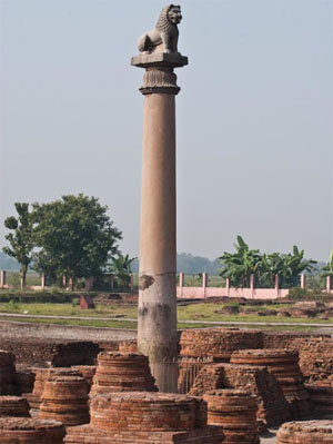
An Asokan pillar with a lion-capital
Who Erected Pillars In India Before Asoka?
The find-spot of a relic is of great importance in the reconstruction of history but one of the many problems in Indian history is that pillars were frequently re-written and re-erected at different locations. Unfortunately the effect of this misuse by later rulers has often been overlooked by gullible historians. Even though the weight of some of the Asokan pillars is about thirty tons, it is not safe to assume that these were erected in their present locations. In the fourteenth century Sultan Feroz Shah was so impressed by the Asokan pillars that he had two of them shifted to Delhi, one from Meerut and another from Topra in Ambala district, about 90 miles northwest of Delhi. F. J. Monahan[iv] wrote,
The fame of Samudragupta as one of the greatest conquerors of India rests on his famous Allahabad inscription which was rewritten on an old Asokan pillar. Kulke and Rothermund[v] suggest that it was transported from Kausambi. In the Mudrarakshasa Chandragupta is called Piadamsana. From this H.C. Raychaudhuri concluded that
Although Asoka was the first to use pillars and other monuments for the propagation of Dhamma, the intriguing fact that emerges from his edicts is that pillars similar to those bearing his edicts had been in existence in India before his time; in the seventh of his Pillar Edicts, after recording that he has erected 'pillars of the Sacred Law' (Dhamma-thambani), Asoka writes,
The crucial question that arises now is who erected these pre-Asokan pillars?
Asoka's 13th Edict Echoes Nebuchadrezzar's Inscription
The thirteenth edict of Asoka occupies a special place for the poignancy of its diction. The humane tone of remorse and the account of the subsequent change of heart of the Emperor after victory in the bloody battle of Kalinga sounds very authentic and moving. One cannot but contrast it with the imperial and swaggering style of Darius' edicts. But as pointed out by Bhattacharya [vi] the reasons for which he fought the battle in the eighth year of his reign are not clear. Kalinga was most probably not modern Orissa [vii] as none of the Orissa edicts mention the war in which one hundred thousand men were killed and fifty thousand taken away as captives. From archaeological data regarding urbanism in the third century BC it can be said that deporting fifty thousand people (to Patna?) would have been an impossible task. Even if one considers a different geographical location, war on such a scale can safely be ruled out as there is no indication from other sources. There can be little doubt regarding victory in a war and the remorse and change of heart of the emperor but the propagandist element in the edict cannot be missed. Asoka is clearly emulating Nebuchadrezzar who also narrated his victory in his eighth year in which many thousands were killed and many more deported. In fact, as we know from the stories of the Old Testament Nebuchadrezzar was one of the greatest heroes whose fame had reached the farthest corners of the ancient world. D. J. Wiseman writes [viii],
The similarity with Asoka's tone cannot be missed. The great king of Babylon was an easterner and it is likely that he was from Seistan [ix] which was also a primary area for Asoka or Diodotus-I.
Gomata Of Seistan Was The True Gotama
It is impossible to study a historical figure without first ascertaining his locale and his era. The Rumminidei edict is unique as it alone lends some credence to the theory that Gotama was an easterner but here also one cannot escape from the possibility that it was brought in from a different location[x]. Even though he was unable to pinpoint Jones' blunder, the eminent archaeologist A. Ghosh wrote in clear terms,
Very few Indologists were prepared to accept the consequences of the fact that the bricks from Lumbini date only from the third century BC [xii]. Vincent Smith [xiii] notes many curious aspects of the Rumminidei inscription; not only that it is not inscribed by Asoka, it does not even claim to have been incised by a royal command. Presumably it was both drafted and engraved by a local authority. A similar inscription found at Kapileswara in Orissa, on the basis of which Chakradhar Mahapatra [xiv] claims that the real home of the Buddha is Orissa, is of a later date.
The nothingness of the archeological finds at Lumbini and elsewhere can only be explained by noting that Gotama was not an easterner - Gomata of the Behistun inscriptions was the true Gotama. [xv] The Avesta speaks of clashes between Zoroaster and Buddha which shows that Gotama was from the northwest. One of the greatest failures of Assyriology was to gloss over the fact that Bagapa of Babylon was Gomata who was the same as Gotama Buddha whose title was Bhagava [xvi]. As early as 1915 Dr. Spooner wrote [xvii] that both Gotama and Chandragupta were from Persia. Although Piprahwa was called Kapilavastu in the Kanishka era, B. N. Mukherjee's enthusiasm [xviii] about its identification as Gotama's birth-place is entirely misplaced; no Buddhist artefacts datable to 6th century BC has been found here. Debala Mitra, who carried out excavations at Lumbini, writes,
Most of the problems disappear once Kuh-e-Khwaja is recognised as the true Kapilavastu. This is where Sir Aurel Stein discovered a Buddhist shrine in the early years of the last century [xx]. Both Herzfeld and Ghirshman described the frescoes of Kuh-e-Khwaja as the earliest known examples of Gandhara art which clearly shows its links with Buddhism.
Echo Of Alexander's Directives In The Rumminidei Edict
The identification of Kapilavastu is of great relevance in the history of Alexander. Historians have not pondered over the fact that Alexander spent nearly two months with the Ariaspians of the Kuh-e-Khwaja area in Seistan. This was when he was hotly pursuing Bessos, his hated enemy [xxi]. His naming of this area as Alexandria Prophthasia clearly shows that Stein's discovery was linked to the birth-place of Gotama. It is significant that the Greek historians also referred to the traditional sanctity of the district. It was said that the Ariaspians enjoyed special privileges as they had given succour to the starving army of Cyrus the great. This is surely not the full story as the holiness of Seistan is well recorded in the Iranian tradition, in particular, the Shahnama. The Indian texts throw more significant light on the history of Ariaspians or Hariasvas who are described as a lost tribe [xxii]. From the Mahabharata we learn that King Hariasva never ate flesh in his life [xxiii]. It is likely that the sage Asvaghosa (Calanus) whose name is given as Sphines or Aspines belonged to the clan of the Ariaspians. Alexander noted that their system of justice was very much like that of the Greeks [xxiv]. Impressed by their way of life and civic administration, Alexander extended their boundaries and conferred nominal freedom. Though not explicitly stated, waiving part of the taxes payable to the state must have been an element of his decree. It is important to note that Alexander's conflicts with his officers started after his stay in Seistan. The Philotas affair, the slaying of Cleitus and the Callisthenes tragedy are all linked with the Alexander's fascination for Gotama and Ariaspians.
The Lion Of Chaeronea And Asoka's Lions
Wheeler was amazed by the double-lion capitals at Persepolis but could not recognise that these could have been erected by Alexander. When the Sarnath pillar was first discovered it created a flutter of sensation on an international scale. Sir John Marshall wrote [xxv],
But what puzzled scholars like Foucher was that if it assumed that Asoka was a native of Bihar as R. Thapar and other Indologists imagine, his fascination for the lion symbol remains an enigma. The lion is an intrusive element in Indian art. On the other hand the lion symbol was much favoured in Mycenae. It was also a symbol of great importance for the Macedonians.
Philip's lion statue at Chaeronea
When Phillip wanted to commemorate the great Macedonian victory at Chaeronea, he setup the famous lion statue. It is thus very likely that his illustrious son had also erected lion capitals in India; it is well known that he always carried a small golden lion. However, it can be argued that Asoka borrowed the lion symbol from Nebuchadrezzar's Babylon - lions guarded the famous E-Sagila - or from the Sumerians who also had a preference for the lion symbol; Gudea's double lion mace-head is well known [xxvi]. As Cumont noted, the lion was a symbol of ancient Lydia. Four lions also guarded the Meghazil tomb near Amrit, but the fact that Asoka was an Indo-Greek closely related to Seleucus' line makes it more likely that his lions were Greek-inspired. However, though truth is indestructible it is often stranger than fiction - the historians job has been made nearly impossible by Asoka who had no qualms about overwriting on the much-sought-after pillars of Alexander.
Alexander's Altar That Once Stood Near Hyphasis
The Englishman Thomas Coryat who came to Delhi in 1616 was one of the first westerners to notice the Asokan pillars after the middle ages. Coryat was greatly impressed by the superbly polished forty feet high monolithic column and presumed that it must have been erected by Alexander the Great 'in token of his victorie' over Porus. In Coryat's time the script of the inscriptions in the pillar was undeciphered but today, thanks to Prinsep, we know that it contains an inscription of Asoka; yet there is more to it than meets the eye. From Asoka's own inscription it is almost certain that some of his pillars were not erected by him.
After the mutiny at Hyphasis Alexander gave up his plans to march further east and to commemorate his presence in India erected twelve massive altars of dressed stone as a thanksgiving to the deities who had blessed his success. Arrian wrote,
Surprisingly, although most of the writers place the altars on the right bank of the river, Pliny placed them on the left or the eastern bank. He wrote (vi, 21),
Alexander's altar was initially at Topra near Chandigarh
Pliny's information suggests a reappraisal of the age-old riddle of Alexander's altars. Precisely how far east had Alexander and his men come? This has been a matter of inconclusive debate; Sir E.H. Banbury held that the point where Alexander erected the twelve altars cannot be regarded as determined within even approximate limits but the Indian evidence now sheds new light on the problem. Masson placed the altars on the united stream of the Hyphasis and Sutlez[xxvii]. McCrindle also wrote that the Sutlez marked the limit of Alexander's march eastward[xxviii] and this is precisely the locality from which Feroze Shah transported a colossal pillar to Delhi. R. Thapar ignores Alexander's momentous voyage[xxix] and writes that though at present there is no archaeological evidence, Topra was probably an important stopping place on the road from Pataliputra to the northwest. This clearly skirts the central issue. It is impossible to think that anyone other than Alexander could have erected such a grand pre-Asokan pillar in this locality. There can be little doubt that the Delhi-Topra pillar [xxx] which now bears Asoka's seventh edict is in fact one of the missing altars of Alexander the Great [xxxi].
Who Was Asoka?
Asoka emerges as the first figure of Indian history about whose era and persona we are fairly well informed. His Edicts speak of a love and sympathy for men and other beings which has very few parallels in world history, [xxxii] yet some very important aspects of his life are still unknown [xxxiii]. Asoka is not known to be represented in any coin or statue. From his study of Buddhist art, Alfred Foucher, one of the greatest commentators on Indian art, raised many questions that apparently had no precise answer. Foucher was surprised to find that the symbols of Buddhism like the lion, the lotus etc. had no antecedents in the art of Eastern India where one must expect them. This is linked to the fact that no original Buddhist texts have been unearthed from modern India. G. Tucci pointed out that even the Stupa is of west Asian origin. Similar views were held by A. Coomaraswamy. "Mahalake hi vijitam" ('Vast is my empire'), proclaimed Ashoka. How extensive really was his dominion in the West? It is impossible to recognize the real Asoka without answering this question. Foucher was not aware of the blunder of Jones or the fact that Kuh-e-Khwaja in Seistan was Kapilavastu[xxxiv], yet solely from his profound study of art history he came to the very significant conclusion that the Mauryan empire must have extended in the north-west to the Hindu-Kush, and to the west as far as Aria and Seistan.
Foucher's remark, in a sense, opens a Pandora's box. If Seistan and Bactria were within the Maurya empire it is not unnatural to expect that the Indo-Greek rulers of Bactria and Seistan were somehow related to the Mauryas. From the fact that Seleucus' daughter became a member of the Mauryan royal family, it can be easily argued that Asoka could have been an Indo-Greek[xxxv]. Asoka's name Asoka Vardhana links him with Parthian Kings like Vardanes, Satibarzanes etc.. R. Thapar suggests that Antiochus could have been his half-brother. It turns out that Asoka's history matches that of Diodotus-I almost line by line.
Devanampiya And Devadatta
R. Thapar writes that the classical writers did not refer to Asoka [xxxvi]. This is clearly absurd ; they must have used a different name, not Asoka or Piyadassi. A careful study shows that Devanampiya, the most common name of Asoka in the Edicts is in fact the same as Devadatta[xxxvii] or Diodotus. The interpretation of Devanampiya as `beloved of the Gods' is superficial. Asoka states that his ancestors were Devanampiyas, which shows that it is a patronymic, not a title - even Chandragupta was a Devanampiya or Diodotus (of Erythrae). 'Nam' in Persian and 'Nomos' in Greek means 'law' another Persian word for which is 'Dat'. Thus Devanam is the same as Devadat. Piya or Priya may have had the sense of a redeemer as in the case of the name of Priam of Troy. Many Parthian Kings assumed the titles Priapatius and Assak. As can be seen from the Shahnama, the Avesta and Xerexes' inscriptions, `Deva' initially meant a clan, not god. Ignorance of this has led to senseless translations of Asoka's Edicts as `Gods mingled with men'. Only oblique scholarship has obscured that the name Devadatta occurring in the second line of Asoka's famous Taxila pillar inscription refers to Asoka himself. The line "l dmy dty `l " [xxxviii] which Marshall and Andreas translated as `for Romedatta', refers to Devadatta.
The Kandahar Edict clearly shows Asoka as the master of Arachosia, whereas the coins indicate that Diodotus was the sovereign of this region. The problem can be resolved only by assuming that Asoka was the same as Diodotus-I. Asoka died exactly when Diodotus died; Asoka's Edicts stopped appearing in 245 BC[xxxix] the year of Diodotus' death. According to Wheeler, the first Edicts were inscribed 'in and after 257BC'. A.K. Narain and others maintain that Diodotus proclaimed himself as king by about 256 BC. The great Indologist F. W. Thomas noted that in his Edicts Asoka did not mention Diodotus Theos who should have been his neighbour[xl]. It is difficult to imagine that the man whose religious overtures won the heart of nearly the entire civilized world failed to impress upon his god-like neighbour. Asoka does not mention Iran also in his Edicts; the nearest foreign king that he mentions being Antiochus. This may indicate that the Syrian King stationed at Seleucia near Babylon was indeed his neighbour. Asoka does not refer to Devadatta because he was Devadatta himself.
Hellenistic Influence On Mauryan Art
The Indo-Greek identity of Asoka throws a flood of light on the history of Mauryan art. Here one must pay tribute to scholars like Sir John Marshall, Alfred Foucher and Niharranjan Ray who were not aware that Asoka was Diodotus-I yet made no mistake in recognising the Hellenistic content of Mauryan art. Marshall realised that the lion capitals of Asoka represent a new era in Indian art that has no precursors. Their fixed expression, authentic spirit, canon-based form and stylisation all betray a strong Hellenistic inspiration. Niharranjan Ray echoes a similar sentiment[xli]. Ray doubted that the impetus could be from Achaemenid Persia and traced it to Hellenistic art. The history of the Topra pillar leaves no doubt about how this stimulus was transmitted. The failure to recognize that Chandragupta was in fact Sasigupta who was once a satrap of Alexander has been at the root of many problems in the interpretation of Gandhara art and Mauryan art. However, though Marshall and Ray came very close to the truth, they failed to see Alexander's hand behind the lions of Asoka.
Nebuchadrezzar And Brotherhood Of Man
Although there is considerable Achaemenian influence[xlii] in Asoka's writing and art it is not difficult to see that his true hero was Nebuchadrezzar whose history is linked with Jainism- Buddhism. As already indicated, Asoka's 13th Edict echoes the campaign of the Babylonian king in his 8th year. Nebuchadrezzar was widely seen as a universal liberator, not a national hero. He was a captor of the Jews yet Jewish Prophets like Jeremiah hailed him as a saviour. Like Asoka, NebuChadrezzar also changed his religion, gave up animal food, was a great temple builder and propagator of religion based on righteousness, (Dhamma) not priestly cults.
Gotama was also strongly influenced by Nebuchadrezzar. The Emperor's horror of the withering tree as told by Daniel in the Old Testament reminds one Gotama's horror of withering, decay and death which played a central role in his renunciation. The same impulse can be seen behind the quest for immortality of Gilgamesh. The great king of Babylon was an easterner and it is likely that the dream is in some way related to the defoliation of the Seistan area which was once a granary of Iran. A strong sentiment against defoliation is also discernible in Buddhist literature and art.
The true significance of Alexander's fascination for Nebuchadrezzar has largely remained unappreciated. Critics who have scoffed at Alexander's call for Brotherhood of Man are not aware that Nebuchadrezzar also wanted to establish a Brotherhood of Man based on righteousness as contrasted to the hegemony of a holy priesthood. Woolley suggested that he introduced a religious reformation that involved congregational worship as contrasted to the priestly rituals. Only Tarn suspected that there may be some religious background to the fact that the Brahmans (the priestly party) were always the strong opponents of Alexander. He was, like Alexander, one of the greatest conquerors of history yet he became a great builder of temples, gave up all animal food and chose to live like a hermit in the forest and courted death by refusing food. This has been senselessly interpreted as madness by some writers unfamiliar with eastern religions. Many Greeks, not only Alexander, saw Nebuchadrezzar as a saviour. Antimenides, brother of the poet Alcaeus fought on behalf of Nebuchadrezzar. Apart from Greek military superiority this is why Alexander was so heartily welcomed in Babylon[xliii].
Alexander And Asoka
The corpus of Asoka's inscriptions is extensive but one is mystified by some things he did not say. Curiously he never names his father or his illustrious grandfather[xliv]. He also maintains a measured silence on Alexander. He opens the famous seventh edict with the sentence,
Who are these kings? The most probable answer is Alexander and Nebuchadrezzar . Plutarch writes that in his days the altars of Alexander were held in much veneration by the Prasiians, whose kings, he says, were in the habit of crossing the Ganges every year to offer sacrifices in the Grecian manner [xlv] upon them. It can be seen from the Mudrarakshasa that even though he played a part in his poisoning, Sasigupta [Sisikottos; Sisocostus !!!] had great respect for Alexander who was once his master. From whatever little we know of Bindusara he probably had the same attitude. This could also have been true of Asoka [xlvi]. His proscription of samajas or revelling parties may be due to his horror of Alexander's poisoning in such a party.
Like Cambyses, Alexander got a very bad press. If his hands were stained by the blood of Cleitus, Asoka was the ruthless terminator of 99 brothers in his youth. This may be echoed by the 'Brother's war' of the classical historians. Susima, Asoka's elder brother who was killed by him before accession to the throne, may be a close relative of Susina (Abd Susin) whose coins have been found from Persepolis. Only Tarn recognised the links between Alexander and Asoka, [xlvii]
Had he been alive, Tarn would have been delighted to learn that it is mainly due to Jones' blunder that Alexander's true legacy remains hidden; his direct influence did not vanish from India within a generation, it only assumed a highly embellished Asokan garb. It is very likely that excavations near the Topra area would yield relics of Alexander which are of crucial importance in world history.
_______________
Notes:
[i] The very existence of the junta depended on a falsification and defamation campaign which was extensive and thoroughgoing. That Ptolemy had to defend Alexander only shows the extent of such a campaign. Needless to say Sasigupta could justify his role only by blackening Alexander. Some Athenian Greeks swayed by Demosthenes' fiery rhetoric spared no effort to belittle Alexander.
[ii] Jones' false discovery of Palibothra at Patna shifted the focus to the east and misled such erudite scholars as Rostovtzeff and Tarn into believing that Alexander is not mentioned in Indian literature and had little influence on Indian civilisation. For an elaboration of the consequences of Jones' mislocation of Palibothra at Patna in lieu of Kahnuj in Gedrosia see 'Sasigupta and the Poisoning of Alexander', to be published.
[iii] See Pal, R., 'Non-Jonesian Indology and Alexander', Minerva Press, New Delhi, 2002.
[iv] Like Vincent Smith, Monahan was a distinguished British historian who was a member of the Indian Civil Service, 'The Early History of Bengal', 1925, p.227.
[v] Kulke, H., and Rothermund, D., 'A History of India', Rupa, 1991, p. 86.
[vi] 'A Dictionary of Indian History', University of Calcutta, 1972, p.70.
[vii] Three Kalingas are mentioned in the Inscriptions. This is natural in view of the fact that early Magadha was in the north-west. The present writer has suggested that there were two Bengals, the earlier one being in the Gulf area. See Pal, R., 'Non-Jonesian Indology and Alexander', Minerva Press, New Delhi, to be published.
[viii] "Nebuchadrezzar and Babylon", British Academy, 1985, p. 98.
[ix] There is a lot of controversy about the correct form of the name which is probably NebuChandressar. The Chandresvaras were an ancient tribe of India. See B.C. Law.
[x] Although some of the points made by Monahan can now be seen to be untrue, his statement is still relevant, "The monoliths in question are believed to have been quarried in the neighbourhood of Chunar in the district of Mirzapur. Quarries yielding the same kind of sandstone are worked there to this day, and no other place is known where the huge blocks required for the purpose could have been obtained. When it is considered that the weight of each of the monoliths is estimated at about 50 tons, it will be apparent that their transport to and erection at such distant sites as Topra near Umballa, Sanchi in Bhopal, and the Nepalese Terai, were no mean engineering feats". 'The Early History of Bengal", Varanasi, 1975 (reprint), p.225.
[xi] Ghosh, A., `The City in Early Historical India', Simla,1972, p70.
[xii] This is not an isolated phenomenon. Christmas Humphreys writes, 'The Lumbini Gardens where Gotama was born, lie in the difficult Nepal Terai, and Kusinara where the Buddha passed away has little to show ...". 'Buddhism', Penguin Books, 1990, p. 42. S.K. Saraswati wrote about Rajagriha in Bihar, `The Buddhist remains, except for stray and isolated images, are scanty..'. Even the identification of the Sattapani cave, the site of the first Council, is not beyond doubt'. Saraswati blamed this to religious bigotry, a precipice much used by Indian scholars but disproved by the example of Babylon which provided archaeological proof of textual history even after countless acts of destruction. Saraswati, S.K., in "2500 years of Buddhism", ed. Bapat, P.V.,1956, p. 279. Debala Mitra writes about Bodh-Gaya, 'The earliest vestiges that are visible now are of the first century BC...'. About Sarnath she writes, 'The earliest remains at Sarnath date from the days of Ashoka, who erected a pillar....'.
[xiii] 'Asoka', Arihant Publishers, Jaipur, 1988 (reprint), p. 223.
[xiv] 'The Real Birthplace of Buddha', Cuttack, Grantha Mandir, 1977.
[xv] The location of Kapilavastu has been so hotly debated. "The mystery of Kapilavastu will continue for many years to be the sport of unverified conjecture", wrote Vincent Smith, a keen observer of the Indian scene. Encyclopedia of Religion and Ethics, vol. ,p .
[xvi] A.L. Oppenheim saw the wide gaps in the studies on Mesopotamian religion.
[xvii] J.R.A.S., 1915, p. 63-89, p. 405-455.
[xviii] "The identification of Kapilavastu, the capital of the Sakyas, with Piprahwa in the Basti district of UP is nearly confirmed by the discovery of thirty- one seals during the excavations at that place which bear the inscriptions of the Kushana period referring to 'the community of the monks of Kapilavastu (residing) in the Devaputra vihara'. An inscription on the lid of a pot also mentions the same monastery, which should have been in Kapilavastu, must have been located in the area of the discoveries of the seals. In other words, the city itself was in the Piprahwa area." P.H.A.I., O.U.P. '96, p. 577. Nalanda has been identified in an equally reckless manner.
[xix] Debala Mitra, 'Buddhist Monuments', \par 20 Geog. Jour., Aug 1916, p. 362. Though both Herzfeld and Ghirshman dated the temple to the Parthian era, this was rejected by Tarn. Scholars are not aware that what goes as Buddhist art today is in fact Hellenised Indian Buddhist art that was patronised by Alexander and Asoka and dates only from the 4th century BC. Only Stein could imagine what pre-Asokan or pre-Alexandrite Buddhist art could look like.
[xx] Geog. Jour. (Aug. 1916) p. 362.
[xxi] Lane Fox notes the event but fails to read the significance of the name Prophthasia. 'Alexander the Great', p. 282.
[xxii] 'Puranic Encyclopedia', by Vettam Mani, Motilal Banarasidas, p.57.
[xxiii]Anusasana Parva, ch. 11, verse 67.
[xxiv] This cannot but remind one of the Lichchavis who had close connections with Gotama.
[xxv] 'Cambridge History of Ancient India', ed. E.J. Rapson, p.562.
[xxvi] Pal, R., 'Gotama Buddha in West Asia', Annals of Bhandarkar Oriental Research Institute, vol. 77.
[xxvii] In this context it has to be borne in mind that in ancient times the two rivers united at a point forty miles below their present junction.
[xxviii] McCrindle, J.W., "Invasion of India by Alexander the Great", New Delhi, p. 120.
[xxix] "Asoka and the Decline of the Mauryas", Oxford University Press", 1961, p.230. For both Raychaudhuri and Thapar, Alexander does not belong to Indian history proper.
[xxx] The precise location is Firozabad near Delhi.
[xxxi] Philostratos' statement that Apollonius of Tyana on his journey into India in the second century A.D. found the altars still intact and their inscriptions still legible probably indicates that they were in places where Alexander had erected them. It is almost certain that Apollonius could not read the inscriptions as they were not in Greek.
[xxxii] H. G. Wells described his reign as one of the brightest interludes in the troubled history of mankind, 'A Short History of the World', p. Wheeler wrote, 'This book is not a history, but in its last chapter the impersonal disjecta of prehistory may fittingly be assembled for a moment in the in the likeness of a man. Ashoka came to the throne about 268 B.C. and died about 232 B.C. Spiritually and materially his reign marks the first coherent expression of the Indian mind, and, for centuries after his empire had crumbled, his work was implicit in the though t and art of the subcontinent. It is not dead today.' 'Early India and Pakistan', Thames and Hudson, 1968, p. 170.
[xxxiii] Apart from his Edicts, archaeology has unearthed very little inscribed material and though some punch-marked coins have been associated with him, this has been disputed. Palaces unearthed near Patna have been said to be his, but in the absence of inscriptions this is clearly unacceptable. Even Taxila, so often mentioned together with his name in the texts, has proved disappointing.
[xxxiv] Pal, R., 'Non-Jonesian Indology and Alexander, op. cit.
[xxxv] Wheeler wrote, 'It is just possible that Ashoka had Seleukid blood in his veins; at least his reputed vice-royalty of Taxila in the Punjab during the reign of his father could have introduced him to the living memory of Alexander the Great, and, as king, he himself tells us of proselytizing relations with the Western powers'. Wheeler came very near the truth yet he narrowly missed the true face of Asoka. 'Early India and Pakistan', Thames and Hudson, 1968, p. 170.
[xxxvi] D.C. Sircar added that Asoka was unknown because there was no foreign representative in his court. This is clearly absurd; the emperor who claims to have sent emissaries no distant corners of the globe cannot have been unknown to the western world.
[xxxvii] After his conversion to Buddhism Asoka had to change his name Devadatta as it was a hated name among the Buddhists.
[xxxviii] B.N. Mukherjee works into the name proper and translates it by the senseless phrase 'for the creation of law '. 'The Aramaic Edicts of Asoka', Indian Museum, p. 26.
[xxxix] R. Thapar is unaware that the reason why Asoka's edicts stopped appearing after 245 BC is that he died in that year. The year of Asoka's death given by Thapar and others is 232 BC but this is clearly a mistake. Diodotus' son, who was also a Diodotus, died in 232 BC.
[xl] 'Asoka', in Cambridge History of Ancient India, p. 453.
[xli] 'Compared with later figural sculptures in the round of Yakshas and their female counterparts or the reliefs of Bharhut, Sanchi and Bodhgaya, the art represented by these crowning lions belongs to an altogether different world of conception and execution, of style and technique, altogether much more complex, urban and civilised. They have nothing archaic or primitive about them, and the presumption is irresistible that the impetus and inspiration of this art must have come from outside.' 'Age of the Nandas and Mauryas', Motilal Banarasidas, 1967, p. 376.
[xlii] Many scholars felt that Asoka was influenced by Darius' inscriptions though his spirit was nobler. The picture at Persepolis of a lion devouring a bull may be Mauryan. Darius or Xerexes could never show the bull, the pride of the Achaemenians, being devoured. Darius always depicted scenes of lion-hunting. Asoka used some words from Darius' Edicts. Barua held that the habitual script of Asoka's scribes was not Brahmi but west Asian Kharoshti and that his artists followed the style of Persepolis. Even the mason's marks were Persepolitan.
[xliii] Alcaeus' lines may well have inspired Alexander and his men.
[xliv] This could be due to two reasons. As Taranatha wrote he may have been a nephew of Bindusara, not a son. Another reason could be his silent disapproval of Chandragupta's role in the murder of Alexander.
[xlv] This could only be a reference to Buddhistic worship which understandably had many similarities with Greek practices.
[xlvi] As a member of Chandragupta's family it is likely that Asoka did not know the full truth about Alexander's poisoning by the Generals and his grandfather or did he?
[xlvii] Tarn, 'Alexander', p.142
by Ranajit Pal (An expanded version of this paper appears in Scholia, vol. 15.)
January, 2006
© University of Otago, 2006
Apart from legends, today the fame of a historical figure is also determined by his archaeological relics. Alexander fell an easy prey to unwary critics mainly due to two factors; his image was tarnished by a vilification campaign launched by the Generals, [ i] who probably poisoned him, and secondly there appears to be very little archeological evidence of his historic voyage [ii]. Sir Mortimer Wheeler wrote with a touch of sorrow,
And yet it is astonishing how very little actual trace we have of his passing... his material presence has eluded us. It is as though a disembodied idea had come and gone as a mighty spiritual force with little immediate tangibility.
However, it has to be remembered that the survival of relics is often a matter of chance. To the layman the accounts of Arrian, Plutarch and others may appear insignificant in contrast to the lustre of the Taj Mahal or the splendour of the relics of Tutenkhamon but the historian must tread more cautiously. Natural disasters like earthquakes and floods, wilful destruction by political or religious reactionaries and at times plain misjudgment of historians may add up to diminish a legitimate hero. Lastly one must also take into account the effects of misappropriation. Had it not been for the ballasting of more than hundred miles of the Lahore-Multan railway with bricks from the monuments of Harappa, the task of reconstructing the glories of the Indus civilisation would have been far easier. This has other dimensions as well; Alexander was keenly aware of the importance of monuments and erected colossal stone altars to record for posterity his presence in northwest India yet nothing survives. In contrast one is confronted with the spectacular emergence of the pillars of Asoka a little more than fifty years later. If one notes that Asoka was an Indo-Greek whose native province was also the northwest [iii], it becomes natural to suspect a link between the sudden appearance of his Pillar edicts and the disappearance of Alexander's altars.
An Asokan pillar with a lion-capital
Who Erected Pillars In India Before Asoka?
The find-spot of a relic is of great importance in the reconstruction of history but one of the many problems in Indian history is that pillars were frequently re-written and re-erected at different locations. Unfortunately the effect of this misuse by later rulers has often been overlooked by gullible historians. Even though the weight of some of the Asokan pillars is about thirty tons, it is not safe to assume that these were erected in their present locations. In the fourteenth century Sultan Feroz Shah was so impressed by the Asokan pillars that he had two of them shifted to Delhi, one from Meerut and another from Topra in Ambala district, about 90 miles northwest of Delhi. F. J. Monahan[iv] wrote,
The fact that ten of the pillars bear inscriptions of Ashoka is proof they were erected not later than his reign; it does not prove that none of them was erected earlier.
The fame of Samudragupta as one of the greatest conquerors of India rests on his famous Allahabad inscription which was rewritten on an old Asokan pillar. Kulke and Rothermund[v] suggest that it was transported from Kausambi. In the Mudrarakshasa Chandragupta is called Piadamsana. From this H.C. Raychaudhuri concluded that
... it is not always safe to ascribe all epigraphs that make mention of Priyadarsana, irrespective of their contents, to Ashoka the Great.
Although Asoka was the first to use pillars and other monuments for the propagation of Dhamma, the intriguing fact that emerges from his edicts is that pillars similar to those bearing his edicts had been in existence in India before his time; in the seventh of his Pillar Edicts, after recording that he has erected 'pillars of the Sacred Law' (Dhamma-thambani), Asoka writes,
The Devanampiya speaks thus: this inscription of Dhamma is to be engraved wherever there are stone pillars or stone slabs, that it may last long.
The crucial question that arises now is who erected these pre-Asokan pillars?
Asoka's 13th Edict Echoes Nebuchadrezzar's Inscription
The thirteenth edict of Asoka occupies a special place for the poignancy of its diction. The humane tone of remorse and the account of the subsequent change of heart of the Emperor after victory in the bloody battle of Kalinga sounds very authentic and moving. One cannot but contrast it with the imperial and swaggering style of Darius' edicts. But as pointed out by Bhattacharya [vi] the reasons for which he fought the battle in the eighth year of his reign are not clear. Kalinga was most probably not modern Orissa [vii] as none of the Orissa edicts mention the war in which one hundred thousand men were killed and fifty thousand taken away as captives. From archaeological data regarding urbanism in the third century BC it can be said that deporting fifty thousand people (to Patna?) would have been an impossible task. Even if one considers a different geographical location, war on such a scale can safely be ruled out as there is no indication from other sources. There can be little doubt regarding victory in a war and the remorse and change of heart of the emperor but the propagandist element in the edict cannot be missed. Asoka is clearly emulating Nebuchadrezzar who also narrated his victory in his eighth year in which many thousands were killed and many more deported. In fact, as we know from the stories of the Old Testament Nebuchadrezzar was one of the greatest heroes whose fame had reached the farthest corners of the ancient world. D. J. Wiseman writes [viii],
His royal inscriptions are marked by the absence of war-like stances and, despite their reuse of paleo-Babylonian traditional epithets, they emphasise 'moral' qualities.
The similarity with Asoka's tone cannot be missed. The great king of Babylon was an easterner and it is likely that he was from Seistan [ix] which was also a primary area for Asoka or Diodotus-I.
Gomata Of Seistan Was The True Gotama
It is impossible to study a historical figure without first ascertaining his locale and his era. The Rumminidei edict is unique as it alone lends some credence to the theory that Gotama was an easterner but here also one cannot escape from the possibility that it was brought in from a different location[x]. Even though he was unable to pinpoint Jones' blunder, the eminent archaeologist A. Ghosh wrote in clear terms,
... the existence of kiln-burnt brick houses distinguished the town from the village.. . An application of this criterion would deny a civic status even to those places which were renowned cities at the time of the Buddha. [xi]
Very few Indologists were prepared to accept the consequences of the fact that the bricks from Lumbini date only from the third century BC [xii]. Vincent Smith [xiii] notes many curious aspects of the Rumminidei inscription; not only that it is not inscribed by Asoka, it does not even claim to have been incised by a royal command. Presumably it was both drafted and engraved by a local authority. A similar inscription found at Kapileswara in Orissa, on the basis of which Chakradhar Mahapatra [xiv] claims that the real home of the Buddha is Orissa, is of a later date.
The nothingness of the archeological finds at Lumbini and elsewhere can only be explained by noting that Gotama was not an easterner - Gomata of the Behistun inscriptions was the true Gotama. [xv] The Avesta speaks of clashes between Zoroaster and Buddha which shows that Gotama was from the northwest. One of the greatest failures of Assyriology was to gloss over the fact that Bagapa of Babylon was Gomata who was the same as Gotama Buddha whose title was Bhagava [xvi]. As early as 1915 Dr. Spooner wrote [xvii] that both Gotama and Chandragupta were from Persia. Although Piprahwa was called Kapilavastu in the Kanishka era, B. N. Mukherjee's enthusiasm [xviii] about its identification as Gotama's birth-place is entirely misplaced; no Buddhist artefacts datable to 6th century BC has been found here. Debala Mitra, who carried out excavations at Lumbini, writes,
In spite of the record of the activities of Ashoka at Kushinagara, nothing that is definitely earlier than the Kushan period, has been found in the excavations [xix].
Most of the problems disappear once Kuh-e-Khwaja is recognised as the true Kapilavastu. This is where Sir Aurel Stein discovered a Buddhist shrine in the early years of the last century [xx]. Both Herzfeld and Ghirshman described the frescoes of Kuh-e-Khwaja as the earliest known examples of Gandhara art which clearly shows its links with Buddhism.
Echo Of Alexander's Directives In The Rumminidei Edict
The identification of Kapilavastu is of great relevance in the history of Alexander. Historians have not pondered over the fact that Alexander spent nearly two months with the Ariaspians of the Kuh-e-Khwaja area in Seistan. This was when he was hotly pursuing Bessos, his hated enemy [xxi]. His naming of this area as Alexandria Prophthasia clearly shows that Stein's discovery was linked to the birth-place of Gotama. It is significant that the Greek historians also referred to the traditional sanctity of the district. It was said that the Ariaspians enjoyed special privileges as they had given succour to the starving army of Cyrus the great. This is surely not the full story as the holiness of Seistan is well recorded in the Iranian tradition, in particular, the Shahnama. The Indian texts throw more significant light on the history of Ariaspians or Hariasvas who are described as a lost tribe [xxii]. From the Mahabharata we learn that King Hariasva never ate flesh in his life [xxiii]. It is likely that the sage Asvaghosa (Calanus) whose name is given as Sphines or Aspines belonged to the clan of the Ariaspians. Alexander noted that their system of justice was very much like that of the Greeks [xxiv]. Impressed by their way of life and civic administration, Alexander extended their boundaries and conferred nominal freedom. Though not explicitly stated, waiving part of the taxes payable to the state must have been an element of his decree. It is important to note that Alexander's conflicts with his officers started after his stay in Seistan. The Philotas affair, the slaying of Cleitus and the Callisthenes tragedy are all linked with the Alexander's fascination for Gotama and Ariaspians.
The Lion Of Chaeronea And Asoka's Lions
Wheeler was amazed by the double-lion capitals at Persepolis but could not recognise that these could have been erected by Alexander. When the Sarnath pillar was first discovered it created a flutter of sensation on an international scale. Sir John Marshall wrote [xxv],
The Sarnath capital, on the other hand, though by no means a masterpiece, is the product of the most developed art of which the world was cognisant in the third century B.C.
But what puzzled scholars like Foucher was that if it assumed that Asoka was a native of Bihar as R. Thapar and other Indologists imagine, his fascination for the lion symbol remains an enigma. The lion is an intrusive element in Indian art. On the other hand the lion symbol was much favoured in Mycenae. It was also a symbol of great importance for the Macedonians.
Philip's lion statue at Chaeronea
When Phillip wanted to commemorate the great Macedonian victory at Chaeronea, he setup the famous lion statue. It is thus very likely that his illustrious son had also erected lion capitals in India; it is well known that he always carried a small golden lion. However, it can be argued that Asoka borrowed the lion symbol from Nebuchadrezzar's Babylon - lions guarded the famous E-Sagila - or from the Sumerians who also had a preference for the lion symbol; Gudea's double lion mace-head is well known [xxvi]. As Cumont noted, the lion was a symbol of ancient Lydia. Four lions also guarded the Meghazil tomb near Amrit, but the fact that Asoka was an Indo-Greek closely related to Seleucus' line makes it more likely that his lions were Greek-inspired. However, though truth is indestructible it is often stranger than fiction - the historians job has been made nearly impossible by Asoka who had no qualms about overwriting on the much-sought-after pillars of Alexander.
Alexander's Altar That Once Stood Near Hyphasis
The Englishman Thomas Coryat who came to Delhi in 1616 was one of the first westerners to notice the Asokan pillars after the middle ages. Coryat was greatly impressed by the superbly polished forty feet high monolithic column and presumed that it must have been erected by Alexander the Great 'in token of his victorie' over Porus. In Coryat's time the script of the inscriptions in the pillar was undeciphered but today, thanks to Prinsep, we know that it contains an inscription of Asoka; yet there is more to it than meets the eye. From Asoka's own inscription it is almost certain that some of his pillars were not erected by him.
After the mutiny at Hyphasis Alexander gave up his plans to march further east and to commemorate his presence in India erected twelve massive altars of dressed stone as a thanksgiving to the deities who had blessed his success. Arrian wrote,
He then divided the army into brigades, which he ordered to prepare twelve altars to equal in height the highest military towers, and to exceed them in point of breadth, to serve as thank offerings to the gods who had led him so far as a conqueror, and also as a memorial of his own labours. When the altars had been constructed, he offered sacrifice upon them with the customary rites, and celebrated a gymnastic and equestrian contest.
Surprisingly, although most of the writers place the altars on the right bank of the river, Pliny placed them on the left or the eastern bank. He wrote (vi, 21),
The Hyphasis was the limit of the marches of Alexander, who, however, crossed it, and dedicated altars on the further bank.
Alexander's altar was initially at Topra near Chandigarh
Pliny's information suggests a reappraisal of the age-old riddle of Alexander's altars. Precisely how far east had Alexander and his men come? This has been a matter of inconclusive debate; Sir E.H. Banbury held that the point where Alexander erected the twelve altars cannot be regarded as determined within even approximate limits but the Indian evidence now sheds new light on the problem. Masson placed the altars on the united stream of the Hyphasis and Sutlez[xxvii]. McCrindle also wrote that the Sutlez marked the limit of Alexander's march eastward[xxviii] and this is precisely the locality from which Feroze Shah transported a colossal pillar to Delhi. R. Thapar ignores Alexander's momentous voyage[xxix] and writes that though at present there is no archaeological evidence, Topra was probably an important stopping place on the road from Pataliputra to the northwest. This clearly skirts the central issue. It is impossible to think that anyone other than Alexander could have erected such a grand pre-Asokan pillar in this locality. There can be little doubt that the Delhi-Topra pillar [xxx] which now bears Asoka's seventh edict is in fact one of the missing altars of Alexander the Great [xxxi].
Who Was Asoka?
Asoka emerges as the first figure of Indian history about whose era and persona we are fairly well informed. His Edicts speak of a love and sympathy for men and other beings which has very few parallels in world history, [xxxii] yet some very important aspects of his life are still unknown [xxxiii]. Asoka is not known to be represented in any coin or statue. From his study of Buddhist art, Alfred Foucher, one of the greatest commentators on Indian art, raised many questions that apparently had no precise answer. Foucher was surprised to find that the symbols of Buddhism like the lion, the lotus etc. had no antecedents in the art of Eastern India where one must expect them. This is linked to the fact that no original Buddhist texts have been unearthed from modern India. G. Tucci pointed out that even the Stupa is of west Asian origin. Similar views were held by A. Coomaraswamy. "Mahalake hi vijitam" ('Vast is my empire'), proclaimed Ashoka. How extensive really was his dominion in the West? It is impossible to recognize the real Asoka without answering this question. Foucher was not aware of the blunder of Jones or the fact that Kuh-e-Khwaja in Seistan was Kapilavastu[xxxiv], yet solely from his profound study of art history he came to the very significant conclusion that the Mauryan empire must have extended in the north-west to the Hindu-Kush, and to the west as far as Aria and Seistan.
Foucher's remark, in a sense, opens a Pandora's box. If Seistan and Bactria were within the Maurya empire it is not unnatural to expect that the Indo-Greek rulers of Bactria and Seistan were somehow related to the Mauryas. From the fact that Seleucus' daughter became a member of the Mauryan royal family, it can be easily argued that Asoka could have been an Indo-Greek[xxxv]. Asoka's name Asoka Vardhana links him with Parthian Kings like Vardanes, Satibarzanes etc.. R. Thapar suggests that Antiochus could have been his half-brother. It turns out that Asoka's history matches that of Diodotus-I almost line by line.
Devanampiya And Devadatta
R. Thapar writes that the classical writers did not refer to Asoka [xxxvi]. This is clearly absurd ; they must have used a different name, not Asoka or Piyadassi. A careful study shows that Devanampiya, the most common name of Asoka in the Edicts is in fact the same as Devadatta[xxxvii] or Diodotus. The interpretation of Devanampiya as `beloved of the Gods' is superficial. Asoka states that his ancestors were Devanampiyas, which shows that it is a patronymic, not a title - even Chandragupta was a Devanampiya or Diodotus (of Erythrae). 'Nam' in Persian and 'Nomos' in Greek means 'law' another Persian word for which is 'Dat'. Thus Devanam is the same as Devadat. Piya or Priya may have had the sense of a redeemer as in the case of the name of Priam of Troy. Many Parthian Kings assumed the titles Priapatius and Assak. As can be seen from the Shahnama, the Avesta and Xerexes' inscriptions, `Deva' initially meant a clan, not god. Ignorance of this has led to senseless translations of Asoka's Edicts as `Gods mingled with men'. Only oblique scholarship has obscured that the name Devadatta occurring in the second line of Asoka's famous Taxila pillar inscription refers to Asoka himself. The line "l dmy dty `l " [xxxviii] which Marshall and Andreas translated as `for Romedatta', refers to Devadatta.
The Kandahar Edict clearly shows Asoka as the master of Arachosia, whereas the coins indicate that Diodotus was the sovereign of this region. The problem can be resolved only by assuming that Asoka was the same as Diodotus-I. Asoka died exactly when Diodotus died; Asoka's Edicts stopped appearing in 245 BC[xxxix] the year of Diodotus' death. According to Wheeler, the first Edicts were inscribed 'in and after 257BC'. A.K. Narain and others maintain that Diodotus proclaimed himself as king by about 256 BC. The great Indologist F. W. Thomas noted that in his Edicts Asoka did not mention Diodotus Theos who should have been his neighbour[xl]. It is difficult to imagine that the man whose religious overtures won the heart of nearly the entire civilized world failed to impress upon his god-like neighbour. Asoka does not mention Iran also in his Edicts; the nearest foreign king that he mentions being Antiochus. This may indicate that the Syrian King stationed at Seleucia near Babylon was indeed his neighbour. Asoka does not refer to Devadatta because he was Devadatta himself.
Hellenistic Influence On Mauryan Art
The Indo-Greek identity of Asoka throws a flood of light on the history of Mauryan art. Here one must pay tribute to scholars like Sir John Marshall, Alfred Foucher and Niharranjan Ray who were not aware that Asoka was Diodotus-I yet made no mistake in recognising the Hellenistic content of Mauryan art. Marshall realised that the lion capitals of Asoka represent a new era in Indian art that has no precursors. Their fixed expression, authentic spirit, canon-based form and stylisation all betray a strong Hellenistic inspiration. Niharranjan Ray echoes a similar sentiment[xli]. Ray doubted that the impetus could be from Achaemenid Persia and traced it to Hellenistic art. The history of the Topra pillar leaves no doubt about how this stimulus was transmitted. The failure to recognize that Chandragupta was in fact Sasigupta who was once a satrap of Alexander has been at the root of many problems in the interpretation of Gandhara art and Mauryan art. However, though Marshall and Ray came very close to the truth, they failed to see Alexander's hand behind the lions of Asoka.
11-3i. Lion capital of column erected by Emperor Asoka (272-232 B.C.) from Patna (ancient Pataliputra), India. Polished sandstone, 7’ high. Archeological Museum, Sarnath
Nebuchadrezzar And Brotherhood Of Man
Although there is considerable Achaemenian influence[xlii] in Asoka's writing and art it is not difficult to see that his true hero was Nebuchadrezzar whose history is linked with Jainism- Buddhism. As already indicated, Asoka's 13th Edict echoes the campaign of the Babylonian king in his 8th year. Nebuchadrezzar was widely seen as a universal liberator, not a national hero. He was a captor of the Jews yet Jewish Prophets like Jeremiah hailed him as a saviour. Like Asoka, NebuChadrezzar also changed his religion, gave up animal food, was a great temple builder and propagator of religion based on righteousness, (Dhamma) not priestly cults.
Gotama was also strongly influenced by Nebuchadrezzar. The Emperor's horror of the withering tree as told by Daniel in the Old Testament reminds one Gotama's horror of withering, decay and death which played a central role in his renunciation. The same impulse can be seen behind the quest for immortality of Gilgamesh. The great king of Babylon was an easterner and it is likely that the dream is in some way related to the defoliation of the Seistan area which was once a granary of Iran. A strong sentiment against defoliation is also discernible in Buddhist literature and art.
The true significance of Alexander's fascination for Nebuchadrezzar has largely remained unappreciated. Critics who have scoffed at Alexander's call for Brotherhood of Man are not aware that Nebuchadrezzar also wanted to establish a Brotherhood of Man based on righteousness as contrasted to the hegemony of a holy priesthood. Woolley suggested that he introduced a religious reformation that involved congregational worship as contrasted to the priestly rituals. Only Tarn suspected that there may be some religious background to the fact that the Brahmans (the priestly party) were always the strong opponents of Alexander. He was, like Alexander, one of the greatest conquerors of history yet he became a great builder of temples, gave up all animal food and chose to live like a hermit in the forest and courted death by refusing food. This has been senselessly interpreted as madness by some writers unfamiliar with eastern religions. Many Greeks, not only Alexander, saw Nebuchadrezzar as a saviour. Antimenides, brother of the poet Alcaeus fought on behalf of Nebuchadrezzar. Apart from Greek military superiority this is why Alexander was so heartily welcomed in Babylon[xliii].
Alexander And Asoka
The corpus of Asoka's inscriptions is extensive but one is mystified by some things he did not say. Curiously he never names his father or his illustrious grandfather[xliv]. He also maintains a measured silence on Alexander. He opens the famous seventh edict with the sentence,
In the past, kings searched for means whereby people's interest in Dhamma would increase, but the people did not respond accordingly with a greater devotion to Dhamma.
Who are these kings? The most probable answer is Alexander and Nebuchadrezzar . Plutarch writes that in his days the altars of Alexander were held in much veneration by the Prasiians, whose kings, he says, were in the habit of crossing the Ganges every year to offer sacrifices in the Grecian manner [xlv] upon them. It can be seen from the Mudrarakshasa that even though he played a part in his poisoning, Sasigupta [Sisikottos; Sisocostus !!!] had great respect for Alexander who was once his master. From whatever little we know of Bindusara he probably had the same attitude. This could also have been true of Asoka [xlvi]. His proscription of samajas or revelling parties may be due to his horror of Alexander's poisoning in such a party.
Like Cambyses, Alexander got a very bad press. If his hands were stained by the blood of Cleitus, Asoka was the ruthless terminator of 99 brothers in his youth. This may be echoed by the 'Brother's war' of the classical historians. Susima, Asoka's elder brother who was killed by him before accession to the throne, may be a close relative of Susina (Abd Susin) whose coins have been found from Persepolis. Only Tarn recognised the links between Alexander and Asoka, [xlvii]
For when all is said, we come back at the end to his personality; not the soldier or the statesman, but the man. Whatever Asia did or did not get from him she felt him as she scarcely felt any other; she knew that one of the greatest of the earth had passed. Though his direct influence vanished from India within a generation, and her literature does not know him, he affected Indian history for centuries; for Chandragupta saw him and deduced the possibility of realising in actual fact the conception, handed down from Vedic times, of a comprehensive monarchy in India; hence Alexander indirectly created Asoka's empire and enabled the spread of Buddhism.
Had he been alive, Tarn would have been delighted to learn that it is mainly due to Jones' blunder that Alexander's true legacy remains hidden; his direct influence did not vanish from India within a generation, it only assumed a highly embellished Asokan garb. It is very likely that excavations near the Topra area would yield relics of Alexander which are of crucial importance in world history.
_______________
Notes:
[i] The very existence of the junta depended on a falsification and defamation campaign which was extensive and thoroughgoing. That Ptolemy had to defend Alexander only shows the extent of such a campaign. Needless to say Sasigupta could justify his role only by blackening Alexander. Some Athenian Greeks swayed by Demosthenes' fiery rhetoric spared no effort to belittle Alexander.
[ii] Jones' false discovery of Palibothra at Patna shifted the focus to the east and misled such erudite scholars as Rostovtzeff and Tarn into believing that Alexander is not mentioned in Indian literature and had little influence on Indian civilisation. For an elaboration of the consequences of Jones' mislocation of Palibothra at Patna in lieu of Kahnuj in Gedrosia see 'Sasigupta and the Poisoning of Alexander', to be published.
[iii] See Pal, R., 'Non-Jonesian Indology and Alexander', Minerva Press, New Delhi, 2002.
[iv] Like Vincent Smith, Monahan was a distinguished British historian who was a member of the Indian Civil Service, 'The Early History of Bengal', 1925, p.227.
[v] Kulke, H., and Rothermund, D., 'A History of India', Rupa, 1991, p. 86.
[vi] 'A Dictionary of Indian History', University of Calcutta, 1972, p.70.
[vii] Three Kalingas are mentioned in the Inscriptions. This is natural in view of the fact that early Magadha was in the north-west. The present writer has suggested that there were two Bengals, the earlier one being in the Gulf area. See Pal, R., 'Non-Jonesian Indology and Alexander', Minerva Press, New Delhi, to be published.
[viii] "Nebuchadrezzar and Babylon", British Academy, 1985, p. 98.
[ix] There is a lot of controversy about the correct form of the name which is probably NebuChandressar. The Chandresvaras were an ancient tribe of India. See B.C. Law.
[x] Although some of the points made by Monahan can now be seen to be untrue, his statement is still relevant, "The monoliths in question are believed to have been quarried in the neighbourhood of Chunar in the district of Mirzapur. Quarries yielding the same kind of sandstone are worked there to this day, and no other place is known where the huge blocks required for the purpose could have been obtained. When it is considered that the weight of each of the monoliths is estimated at about 50 tons, it will be apparent that their transport to and erection at such distant sites as Topra near Umballa, Sanchi in Bhopal, and the Nepalese Terai, were no mean engineering feats". 'The Early History of Bengal", Varanasi, 1975 (reprint), p.225.
[xi] Ghosh, A., `The City in Early Historical India', Simla,1972, p70.
[xii] This is not an isolated phenomenon. Christmas Humphreys writes, 'The Lumbini Gardens where Gotama was born, lie in the difficult Nepal Terai, and Kusinara where the Buddha passed away has little to show ...". 'Buddhism', Penguin Books, 1990, p. 42. S.K. Saraswati wrote about Rajagriha in Bihar, `The Buddhist remains, except for stray and isolated images, are scanty..'. Even the identification of the Sattapani cave, the site of the first Council, is not beyond doubt'. Saraswati blamed this to religious bigotry, a precipice much used by Indian scholars but disproved by the example of Babylon which provided archaeological proof of textual history even after countless acts of destruction. Saraswati, S.K., in "2500 years of Buddhism", ed. Bapat, P.V.,1956, p. 279. Debala Mitra writes about Bodh-Gaya, 'The earliest vestiges that are visible now are of the first century BC...'. About Sarnath she writes, 'The earliest remains at Sarnath date from the days of Ashoka, who erected a pillar....'.
[xiii] 'Asoka', Arihant Publishers, Jaipur, 1988 (reprint), p. 223.
[xiv] 'The Real Birthplace of Buddha', Cuttack, Grantha Mandir, 1977.
[xv] The location of Kapilavastu has been so hotly debated. "The mystery of Kapilavastu will continue for many years to be the sport of unverified conjecture", wrote Vincent Smith, a keen observer of the Indian scene. Encyclopedia of Religion and Ethics, vol. ,p .
[xvi] A.L. Oppenheim saw the wide gaps in the studies on Mesopotamian religion.
[xvii] J.R.A.S., 1915, p. 63-89, p. 405-455.
[xviii] "The identification of Kapilavastu, the capital of the Sakyas, with Piprahwa in the Basti district of UP is nearly confirmed by the discovery of thirty- one seals during the excavations at that place which bear the inscriptions of the Kushana period referring to 'the community of the monks of Kapilavastu (residing) in the Devaputra vihara'. An inscription on the lid of a pot also mentions the same monastery, which should have been in Kapilavastu, must have been located in the area of the discoveries of the seals. In other words, the city itself was in the Piprahwa area." P.H.A.I., O.U.P. '96, p. 577. Nalanda has been identified in an equally reckless manner.
[xix] Debala Mitra, 'Buddhist Monuments', \par 20 Geog. Jour., Aug 1916, p. 362. Though both Herzfeld and Ghirshman dated the temple to the Parthian era, this was rejected by Tarn. Scholars are not aware that what goes as Buddhist art today is in fact Hellenised Indian Buddhist art that was patronised by Alexander and Asoka and dates only from the 4th century BC. Only Stein could imagine what pre-Asokan or pre-Alexandrite Buddhist art could look like.
[xx] Geog. Jour. (Aug. 1916) p. 362.
[xxi] Lane Fox notes the event but fails to read the significance of the name Prophthasia. 'Alexander the Great', p. 282.
[xxii] 'Puranic Encyclopedia', by Vettam Mani, Motilal Banarasidas, p.57.
[xxiii]Anusasana Parva, ch. 11, verse 67.
[xxiv] This cannot but remind one of the Lichchavis who had close connections with Gotama.
[xxv] 'Cambridge History of Ancient India', ed. E.J. Rapson, p.562.
[xxvi] Pal, R., 'Gotama Buddha in West Asia', Annals of Bhandarkar Oriental Research Institute, vol. 77.
[xxvii] In this context it has to be borne in mind that in ancient times the two rivers united at a point forty miles below their present junction.
[xxviii] McCrindle, J.W., "Invasion of India by Alexander the Great", New Delhi, p. 120.
[xxix] "Asoka and the Decline of the Mauryas", Oxford University Press", 1961, p.230. For both Raychaudhuri and Thapar, Alexander does not belong to Indian history proper.
[xxx] The precise location is Firozabad near Delhi.
[xxxi] Philostratos' statement that Apollonius of Tyana on his journey into India in the second century A.D. found the altars still intact and their inscriptions still legible probably indicates that they were in places where Alexander had erected them. It is almost certain that Apollonius could not read the inscriptions as they were not in Greek.
[xxxii] H. G. Wells described his reign as one of the brightest interludes in the troubled history of mankind, 'A Short History of the World', p. Wheeler wrote, 'This book is not a history, but in its last chapter the impersonal disjecta of prehistory may fittingly be assembled for a moment in the in the likeness of a man. Ashoka came to the throne about 268 B.C. and died about 232 B.C. Spiritually and materially his reign marks the first coherent expression of the Indian mind, and, for centuries after his empire had crumbled, his work was implicit in the though t and art of the subcontinent. It is not dead today.' 'Early India and Pakistan', Thames and Hudson, 1968, p. 170.
[xxxiii] Apart from his Edicts, archaeology has unearthed very little inscribed material and though some punch-marked coins have been associated with him, this has been disputed. Palaces unearthed near Patna have been said to be his, but in the absence of inscriptions this is clearly unacceptable. Even Taxila, so often mentioned together with his name in the texts, has proved disappointing.
[xxxiv] Pal, R., 'Non-Jonesian Indology and Alexander, op. cit.
[xxxv] Wheeler wrote, 'It is just possible that Ashoka had Seleukid blood in his veins; at least his reputed vice-royalty of Taxila in the Punjab during the reign of his father could have introduced him to the living memory of Alexander the Great, and, as king, he himself tells us of proselytizing relations with the Western powers'. Wheeler came very near the truth yet he narrowly missed the true face of Asoka. 'Early India and Pakistan', Thames and Hudson, 1968, p. 170.
[xxxvi] D.C. Sircar added that Asoka was unknown because there was no foreign representative in his court. This is clearly absurd; the emperor who claims to have sent emissaries no distant corners of the globe cannot have been unknown to the western world.
[xxxvii] After his conversion to Buddhism Asoka had to change his name Devadatta as it was a hated name among the Buddhists.
[xxxviii] B.N. Mukherjee works into the name proper and translates it by the senseless phrase 'for the creation of law '. 'The Aramaic Edicts of Asoka', Indian Museum, p. 26.
[xxxix] R. Thapar is unaware that the reason why Asoka's edicts stopped appearing after 245 BC is that he died in that year. The year of Asoka's death given by Thapar and others is 232 BC but this is clearly a mistake. Diodotus' son, who was also a Diodotus, died in 232 BC.
[xl] 'Asoka', in Cambridge History of Ancient India, p. 453.
[xli] 'Compared with later figural sculptures in the round of Yakshas and their female counterparts or the reliefs of Bharhut, Sanchi and Bodhgaya, the art represented by these crowning lions belongs to an altogether different world of conception and execution, of style and technique, altogether much more complex, urban and civilised. They have nothing archaic or primitive about them, and the presumption is irresistible that the impetus and inspiration of this art must have come from outside.' 'Age of the Nandas and Mauryas', Motilal Banarasidas, 1967, p. 376.
[xlii] Many scholars felt that Asoka was influenced by Darius' inscriptions though his spirit was nobler. The picture at Persepolis of a lion devouring a bull may be Mauryan. Darius or Xerexes could never show the bull, the pride of the Achaemenians, being devoured. Darius always depicted scenes of lion-hunting. Asoka used some words from Darius' Edicts. Barua held that the habitual script of Asoka's scribes was not Brahmi but west Asian Kharoshti and that his artists followed the style of Persepolis. Even the mason's marks were Persepolitan.
[xliii] Alcaeus' lines may well have inspired Alexander and his men.
From the ends of the earth you are come,
With your sword hilts of ivory bound with gold ....
Fighting beside the Babylonians you accomplished a great labour,
And delivered them from distress,
For you slew a warrior who wanted only a palm's breadth of five royal cubits.
[xliv] This could be due to two reasons. As Taranatha wrote he may have been a nephew of Bindusara, not a son. Another reason could be his silent disapproval of Chandragupta's role in the murder of Alexander.
[xlv] This could only be a reference to Buddhistic worship which understandably had many similarities with Greek practices.
[xlvi] As a member of Chandragupta's family it is likely that Asoka did not know the full truth about Alexander's poisoning by the Generals and his grandfather or did he?
[xlvii] Tarn, 'Alexander', p.142
- admin
- Site Admin
- Posts: 41342
- Joined: Thu Aug 01, 2013 5:21 am
Re: Freda Bedi Cont'd (#3)
![]() by admin » Sat Sep 04, 2021 4:08 am
by admin » Sat Sep 04, 2021 4:08 am
Part 1 of 3
An Altar of Alexander Now Standing at Delhi [EXPANDED VERSION]
by Ranajit Pal
Bhandarkar Oriental Research Institute,
Pune, India.
January, 2006
© University of Otago, 2006
Abstract. The vanishing of the twelve magnificent altars set up by Alexander the Great has intrigued many scholars. This article shows that one of the Altars was reinscribed by Emperor ASHOKA, WHO WAS THE FAMOUS INDO-GREEK KING DIODOTUS I. There is an indication that Alexander may have tried to promote brotherhood in these altars. It is just possible that the four-lion emblem of India may be linked to Alexander.
Even in the heyday of Assyriology, when the lure of grand discoveries drew archaeologists to Sumer and Akkad, some eminent figures opted for India. Apart from the enigma of the Indus culture, a prime attraction was the undiscovered altars of Alexander cited in several ancient texts. Alexander was the greatest ambassador of the West, and the failure to locate the altars saddened eminent archaeologists like Sir Mortimer Wheeler, who writes:
The vanishing of the altars was seen by some as an index of the insignificance of Alexander’s legacy, and was at the root of much ignorant criticism levelled against him. However, survival of relics is often a matter of chance; to the layman the accounts of Arrian, Plutarch and others may appear trivial in contrast to the lustre of the Taj Mahal or the splendour of Tutenkhamun’s relics, but the historian must tread cautiously. Natural disasters like earthquakes and floods, wilful destruction by political or religious reactionaries, and at times plain misjudgment of historians, may accumulate in order to diminish a legitimate hero. Lastly one must consider the effects of misappropriation. Had it not been for the ballasting of more than one hundred miles of the Lahore-Multan railway with bricks from the monuments of Harappa, the task of reconstructing the glories of the Indus civilisation would have been far easier.
This background has other dimensions as well: only a little more than fifty years after the construction of the altars, all of which apparently disappeared, one encounters the majestic Asokan pillars. Since Asoka has a very strong presence in the northwest, it is natural to suspect a link between the vanishing of all the altars of Alexander and the simultaneous emergence of nearly the same number of his pillar edicts, many of which had lion-capitals. It can be recalled that when Philip wanted to commemorate the momentous victory at Chaeronea he set up the famous lion statue. It is more than likely that his illustrious son had also erected lion capitals in India.
Who Erected Pillars In India before Asoka?
The find-spots of relics are of great importance in the reconstruction of history; but one of the recurrent problems in Indian history is that pillars were often rewritten and re-erected at different locations. Unfortunately this has been totally ignored by gullible historians like H. C. Raychaudhuri and R. Thapar. Even though the weight of some of these pillars is about thirty tons, it is not safe to assume that they were erected in their present locations. Keay writes:
Significantly, although most writers placed this quarry at Chunar near Benares, Prinsep located it somewhere in the outer Himalayas. The altars of Alexander were grand structures. Plutarch writes that in his day these were held in much veneration by the Prasiians, whose kings were in the habit of crossing the Ganges every year to offer sacrifices in the Grecian manner upon them (Plut. Alexander, 62). What happened thereafter? Was there a scramble among the later rulers to use these splendid monuments for their own purposes? The fame of Samudragupta as one of the greatest rulers of India rests on his famous Allahabad inscription which was rewritten on an old Asokan pillar. Kulke and Rothermund suggest that it was shifted from Kausambi. In the fourteenth4 century, Sultan Feroz Shah was so impressed by the Asokan pillars that he had two of them shifted to Delhi, one from Meerut and another from Topra in Ambala district, about 90 miles northwest of Delhi.
Monahan writes:
In the Sanskrit drama Mudrarakshasa, Chandragupta is called Piadamsana.6 From this, Raychaudhuri concludes that it is not always safe to ascribe all epigraphs that mention Priyadarsana to Ashoka the Great. The intriguing fact7 is that Asoka says that pillars bearing edicts had been in existence in India before his time; he was not the first to use pillars for the propagation of Dhamma (Eusebia). In the seventh Pillar Edict, after recording that he has erected ‘pillars of the Sacred Law’ (dhammathambani), Asoka writes:
This shows that there were already pillars in India before the Asokan era and also implies that, like Samudragupta, Asoka also had engraved his own message on at least some of them. To realise that no one other than Alexander could have erected these pre-Asokan pillars, one has to take a close look into an age-old blunder in Indology that has greatly falsified world history.
The Location of Palibothra
Alexander historians have often been baffled by the scarcity of new sources, archaeological or textual, and new writers are usually content with reinterpretation of old documents. Unfortunately this is due to a faulty9 perspective; too much stress has been laid on the Greek and Roman sources at the expense of crucial data from Sanskrit and Pali documents. Moreover, the value of the Indian sources has been impaired by one fatal error—Jones’s location of Palibothra at Patna. This has not only blurred the identity of major10 conspirators in the history of Alexander, but has also left room for much injudicious criticism against him. Once Jones’s idea is rejected and the scenario is shifted to the northwest, important clarifications emerge in the history not only of India but also that of Iran and Afghanistan. It turns out that Alexander11 was chasing through Gedrosia a very powerful adversary, and that he was not quite the villain that he has been made out to be.
Recounting the scenario after the Hyphasis mutiny (Arr. 5.25, Diod. 17.93-5, Curt. 9.2.1-3.19), Badian writes with an air of definiteness:
Badian not only finds Alexander in an awkward position, but also casually notes his subsequent declaration that he would go on nonetheless and his ordering of sacrifices for crossing the river. Alexander’s vow to fight against the Prasii in13 the face of stiff opposition from both the soldiers and officers does appear somewhat comical but here lies a trap—where was their capital Palibothra? Could it really have been at Patna, so far removed from the northwest—the centre of early India?
The significance of this question has been glossed over by all. Only Hammond, discoverer of Aegai, recognises the crucial role of geography in history, and states that ‘Patna is too far east’ to be a Palibothra. Renowned14 archaeologists like A. Ghosh also point out that Jones’s discovery has no archaeological basis. Kulke and Rothermund likewise doubt the Jonesian15,16 story. It is well known that the Maurya empire extended to the west as far as Aria, Seistan and Makran and this makes it likely that Palibothra was in this17 region. Elisseeff remarks that from the archaeological viewpoint, eastern Iran18 was closer to India. Bivar is unaware of Jones’ error or the appalling frauds in19 Nepalese archaeology and his view about the Persepolis tablets is heedless and 20 empty:
The tablets not only throw invaluable light on the geography of greater India but provide data that revolutionise Indology. Sedda Saramana of the tablets appears to be Siddhartha (Sedda-Arta) Gotama and the ubiquitous Suddayauda Saramana seems to be his father Suddo-dhana. Al-beruni writes that Gotama’s real name was Buddho-dana which puts him in the same bracket as Daniel.22 Nunudda of the tablets may be Nanda, a relative of Gotama.
Alexander’s Return Through Gedrosia After the Hyphasis Mutiny
Through the mist of vague reports and geographical misconceptions, it is difficult to probe into the Hyphasis revolt, which came as a serious jolt to Alexander. After this, even though there were safer routes, Alexander chose to return to Iran through the desert of Gedrosia, suffering heavy losses in soldiers and civilians from lack of water, food and the extreme heat. That the motive behind this voyage has appeared so perplexing is due to two crucial lapses—the false location of Palibothra, capital of the Prasii, and the concomitant failure to recognise the mysterious Moeris of Pattala who played a determinant role.
‘Alexander, of course, had read Herodotus’, writes Badian, but misses23 the purport of his reference to Indians in the Gedrosia area. Toynbee writes on world history and makes no mistake to note the shifting nature of India’s boundary:
The reports of Alexander’s historians clearly indicate that southeast Iran was within Greater India in the fourth century BC. As Prasii was in the Gedrosia area, the question arises—did the army refuse to fight the Prasii or only to march eastwards? If Alexander wanted to move eastward it was not to defeat the Prasii. Tarn writes that he had nothing to do with Magadha on the Ganges. If25 he had learnt that the fertile Gangetic plains were only a few days’ march away, and wanted to be there for mere expansion of empire, he would have met little resistance. Reluctance of the army could be due to the lack of any tangible gain, not fear of the mighty Easterners. If this was the case, then Alexander bowed down to the wishes of his men. However, if the reluctance was to confront the Prasii, it appears sensible due to their formidable strength. As Moeris had fought beside Porus, the Prasiian army cannot have been left intact, though it could still have been a fighting force. It is probable that Moeris and his agents fomented discord among Alexander’s officers and soldiers. The magicians and26 other secret agents of Moeris probably overblew the might of the Prasii in order to frighten the invaders. From this point onwards, if not earlier, Eumenes, Perdikkas and Seleucus may have been in touch with Moeris.
Victory Over Moeris At Palibothra
Only Justin (Just. xii, 8) reports that Alexander had defeated the Prasii.
Palibothra, the Prasiian capital was famous for peacocks. Lane Fox writes:
Curiously, Arrian writes that Alexander was so charmed by the beauty of peacocks that he decreed the severest penalties against anyone killing them (Arrian, Indica, xv.218). The picture of Alexander amidst peacocks appears28 puzzling: where did he come across the majestic bird? Does this fascination lead us to Palibothra? The height of absurdity is reached when we are told that eighteen months after the battle with Porus, Alexander suddenly remembered his ‘victory over the Indians’ in the wilderness of Carmania and set upon to celebrate it with fabulous mirth and abandon. Surprisingly it did not jar with the common sense of anyone why this was not celebrated in India. The ‘victory over the Indians’ in southeast Iran can lead to only one judicious conclusion—this was India in the fourth century BC. Moreover, if Alexander had indeed defeated the Indians, who could have been their leader but Moeris or Maurya? This clearly indicates that Alexander had indeed conquered the Prasii in Gedrosia.
Bosworth writes that the name of the place where the victory was celebrated was Kahnuj. The name tells all, for Kanauj was the chief city of the29 Indians, the name of which is echoed in the famous city in eastern India which later became most important.
[29. A. B. Bosworth, Conquest and Empire: The Reign of Alexander the Great (Cambridge 1988) 150, who gives the name Khanu (maps usually give the name Kohnouj or Kahnuj). Nearby Patali may have been Palibothra.]
An Altar of Alexander Now Standing at Delhi [EXPANDED VERSION]
by Ranajit Pal
Bhandarkar Oriental Research Institute,
Pune, India.
January, 2006
© University of Otago, 2006
That the history of Asoka matches that of Diodotus I line by line can only imply that they were one and the same person....
The Parthian Prince An-shih-kao, who dedicated his life to the spread of Buddhism, is clearly Diodotus...
Asoka does not refer to Diodotus because he was Diodotus himself...
Historians have denied Diodotus his true place in world history.
-- An Altar of Alexander Now Standing at Delhi [EXPANDED VERSION], by Ranajit Pal
Diodotus was born between 315-300 BC, likely to parents established as nobles in Bactria. His father (also Diodotus) was believed to have been a dignitary and Diadochi of Alexander the Great, awarded land in Bactria.
The region of Bactria, which encompassed the Oxus river Valley in modern Afghanistan and Tajikistan, was conquered by Alexander between 329 and 327 BC and he settled a number of his veterans in the region. In the wars which followed Alexander's death in 323 BC, the region was largely left to its own devices, but it was incorporated in the Seleucid empire by Seleucus I between 308 and 305 BC, along with the rest of the territories that Alexander had conquered in Iran and Central Asia. Seleucus entrusted the region to his son and co-regent, Antiochus I, around 295 BC. Between 295 and 281 BC, Antiochus I established firm Seleucid control over the region. The region was divided into a number of satrapies (provinces), of which Bactria was one. Antiochus founded or refounded a number of cities on the Greek model in the region and he opened a number of mints to produce coinage on the Attic weight standard. After Antiochus I succeeded his father as ruler of the Seleucid empire in 281 BC, he entrusted the east to his own son, Antiochus II who remained in this position until he in turn succeeded to the throne in 261 BC.[8]
Diodotus became Seleucid satrap (governor) of Bactria during Antiochus II's reign, thus about a generation after the original establishment of Seleucid control over the region .... Archaeological evidence for the period comes largely from excavations of the city of Ai-Khanoum, where this period saw the expansion of irrigation networks, the construction and expansion of civic buildings, and some military activity...
At some point, Diodotus seceded from the Seleucid empire, establishing his realm as an independent kingdom, known in modern scholarship as the Graeco-Bactrian kingdom. The event is mentioned briefly by the Roman historian Justin:Diodotus, the governor of the thousand cities of Bactria, defected and proclaimed himself king; all the other people of the Orient followed his example and seceded from the Macedonians [i.e. the Seleucids].
— Justin Epitome of Pompeius Trogus 41.4...
The limited archaeological evidence reveals no signs of discontinuity or destruction in this period. The transition from Seleucid rule to independence thus seems to have been accomplished peacefully....
The literary sources stress the prosperity of the new kingdom. Justin calls it "the extremely prosperous empire of the thousand cities of Bactria.", while the geographer Strabo says:The Greeks who caused Bactria to revolt grew so powerful on account of the fertility of the country that they became masters, not only of Ariana, but also of India, as Apollodorus of Artemita says: and more tribes were subdued by them than by Alexander... Their cities were Bactra (also called Zariaspa, through which flows a river bearing the same name and emptying into the Oxus), and Darapsa, and several others.
— Strabo Geography 11.11.1
[A]rchaeological evidence makes clear that goods and people continued to move between Bactria and the Seleucid realm.
Diodotus died during the reign of Seleucus II, sometime around 235 BC, probably of natural causes. He was succeeded by his son Diodotus II. The new king concluded a peace with the Parthians and supported Arsaces when Seleucus II attacked him around 228 BC. Diodotus II was subsequently killed by an usurper, Euthydemus [a Greco-Bactrian king], who founded the Euthydemid dynasty....
Diodotus appears also on coins struck in his memory by the later Graeco-Bactrian kings Agathocles and Antimachus. These coins imitate the original design of the tetradrachms issued by Diodotus I, but with a legend on the obverse identifying the king as Ancient Greek: ΔΙΟΔΟΤΟΥ ΣΩΤΗΡΟΣ ('Of Diodotus Soter' [saviour]).
-- Diodotus I, by Wikipedia
In my ten months journey between Aleppo and this court, I spent just three pounds sterling, yet fared reasonably every day; victuals being so cheap in some of the countries through which I travelled, that I often lived competently for one penny a-day. Of that three pounds, I was actually cozened out of ten shillings, by certain evil Christians of the Armenian nation; so that in reality I only expended fifty shillings in all that time. I have been in a city of this country called Delee, where Alexander the Great joined battle, with Porus king of India, and defeated him; and where, in memory of his victory, he caused erect a brazen pillar, which remains there to this day. At this time I have many irons in the fire, as I am learning the Persian, Turkish, and Arabic languages, having already acquired the Italian. I have been already three months at the court of the Great Mogul, and propose, God willing, to remain here five months longer, till I have got these three languages; after which I propose to visit the river Ganges, and then to return to the court of Persia.
-- A General History and Collection of Voyages and Travels, Arranged in Systematic Order: Forming a Complete History of the Origin and Progress of Navigation, Discovery, and Commerce, by Sea and Land, From the Earliest Ages to the Present Time, by Robert Kerry, F.R.S. & F.A.S. Edin., Illustrated by Maps and Charts, Vol. IX, 1824
Asoka’s Lat. —
The next object of interest in the palace of Firoz Shah is the pillar on which Asoka, king of Magadha, published his tolerant edicts to the world. It was put up here by Firoz Shah, in the year 757 A.H. (1356 A D.) It stands on a pyramidal building of rubble stone, with domes of rubble stone irregularly set in mortar of admirable quality, and arches with ribs. [Beglar.]
The pyramid consists of terraces standing on an exterior platform, on the top-most of which the pillar stands; these terraces have cells with arches all round. [Muhammad Anim Razi in his Haft-i-Kalim, describes the pillar, as it was in the time of Akbar, as standing on a house three-storeyed high, being “a monolith of red-stone tapering upwards.” “The three storeys,” says Franklin, “were partly a menagerie, and partly an aviary.” From where this idea was got hold of, I am unable to say.] I agree with Mr. Beglar that there was not another storey over the highest storey now in existence; the presence of two stumps of pillars near the edge of the upper-most storey does not argue, as a matter of even strong probability, that they were parts of pillar- supports, but I am of opinion, that the addition of another storey which would serve to dwarf the size of the pillar would be an ill advised addition for men who were setting up a lofty monument to the glory of their king. The fact that the domes over the four corner towers of the third storey are on a level with the present main roof, is decidedly in favour of the theory that the building was never higher than it is now. “Vertically beneath the base of the pillar, a gallery has been broken through in the top-most storey, disclosing a sort of rough chamber, covered by a rubble dome 4 feet in diameter, on which consequently, the entire weight of the pillar rests. [ Beglar.]
Asoka, king of Magadha, subsequently known as Dhammasoka, was the son of Bindusara, and grandson of Chandra Gupta, “the king of Hindusthan, from Kashmir to Kanauj.” He was born in the orthodox faith, and was a worshipper of Shiva, but became a convert to Bhuddism, and a powerful propagandist of his new faith. He commemorated his conversion and his desire that his new faith should be spread over his empire, by the promulgation of edicts which still stand as undying memorials of his faith, on granite pillars which were erected from Kabul to Orissa. Asoka is the Piyadasi of the pillar inscriptions and Pali records; the contemporary of Antiochus Theos, and his age may be placed between 325-200 B.C.
The pillar under notice is a sand-stone monolith, 42 feet 7 inches high, of which the upper portion of 35 feet is polished and the rest is left rough; the buried portion of the pillar is 4 feet 1 inch long. [Beglar.] Its upper diameter is 25-3 inches and its lower diameter 38-8 inches, the diminution being -39 inches per foot. [Cunningham.] The pillar is supposed to weigh 27 tons. The colour of the stone is pale pink, having black spots outside, something like dark quartz. The usual amount of inaccuracies has found its way in the measurements of this pillar: Major Burt, who examined it in 1837, gives its length as about 35 feet, and diameter as 3-1/4 feet; Franklin gives 50 feet as its length; Von Orlich, 42 feet; William Finch, 24 feet; Shams-i-Siraj, 24 gaz or 34 feet, and its circumference 10 feet. As regards the material of the monolith and the inscriptions it bears, some very curious mistakes have also been made: the Danish Councillor, de Laet, describes it as “a very high obelisk (as some affirm) with Greek characters and placed here (as it is believed) by Alexander the Great;" the eccentric Tom Coryat also ascribes the pillar to Alexander and describes it as “brazen;" the confiding Chaplain Edward Terry, who was so charmed with Coryat’s improbable stories, improves on his informant and calls it a "very great pillar of marble” of Alexander the Great; but strange to say, that the observant Bishop Heber describes it as a pillar of “cast metal,” and, that the description was not an ordinary slip of the pen, is evident from the fact that the Bishop refers to it, to explain the material of the Iron Pillar, both being, in his lordship’s opinion, of “cast metal."
-- Archaeology and Monumental Remains of Delhi, by Carr Stephen, 1876
Delhi is situated in a fine plain; and about two coss [3.6 miles] from thence are the ruins of a hunting seat, or mole, built by Sultan Bemsa, a great Indian sovereign [NOT "Togall Shah"]. It still contains much curious stone-work; and above all the rest is seen a stone pillar, which, after passing through three several stories, rises twenty-four feet above them all, having on the top a globe, surmounted by a crescent. It is said that this stone stands as much below in the earth as it rises above, and is placed below in water, being all one stone. Some say Naserdengady, a Patan king, wanted to take it up, but was prevented by a multitude of scorpions. It has inscriptions.6 [Purchas alleges that these inscriptions are in Greek and Hebrew; and that some affirm it was erected by Alexander the Great.—E.] In divers parts of India the like are to be seen....
From Sirhind, in five stages, making forty-eight coss [86.4 miles], I came to a serai called Fetipoor, built by the present king Shah Selim, in memory of the overthrow of his eldest son, Sultan Cussero, on the following occasion. On some disgust, Shah Selim took up arms in the life of his father Akbar, and fled into Purrop, where he kept the strong castle of Alobasse7 [Purrop, or Porub, has been formerly supposed the ancient kingdom of Porus in the Punjab, and Attobass, here called Alobasse, to have been Attock Benares. — E.] but came in and submitted about three months before his father’s death.
-- A General History and Collection of Voyages and Travels, Arranged in Systematic Order: Forming a Complete History of the Origin and Progress of Navigation, Discovery, and Commerce, By Sea and Land, From the Earliest Ages to the Present Time, by Robert Kerr, F.R.S. & F.A.S. Edin., Vol. VIII, 1824
Abstract. The vanishing of the twelve magnificent altars set up by Alexander the Great has intrigued many scholars. This article shows that one of the Altars was reinscribed by Emperor ASHOKA, WHO WAS THE FAMOUS INDO-GREEK KING DIODOTUS I. There is an indication that Alexander may have tried to promote brotherhood in these altars. It is just possible that the four-lion emblem of India may be linked to Alexander.
Even in the heyday of Assyriology, when the lure of grand discoveries drew archaeologists to Sumer and Akkad, some eminent figures opted for India. Apart from the enigma of the Indus culture, a prime attraction was the undiscovered altars of Alexander cited in several ancient texts. Alexander was the greatest ambassador of the West, and the failure to locate the altars saddened eminent archaeologists like Sir Mortimer Wheeler, who writes:
And yet it is astonishing how very little actual trace we have of his passing... his material presence has eluded us. It is as though a disembodied idea had come and gone as a mighty spiritual force with little immediate tangibility. 2
The vanishing of the altars was seen by some as an index of the insignificance of Alexander’s legacy, and was at the root of much ignorant criticism levelled against him. However, survival of relics is often a matter of chance; to the layman the accounts of Arrian, Plutarch and others may appear trivial in contrast to the lustre of the Taj Mahal or the splendour of Tutenkhamun’s relics, but the historian must tread cautiously. Natural disasters like earthquakes and floods, wilful destruction by political or religious reactionaries, and at times plain misjudgment of historians, may accumulate in order to diminish a legitimate hero. Lastly one must consider the effects of misappropriation. Had it not been for the ballasting of more than one hundred miles of the Lahore-Multan railway with bricks from the monuments of Harappa, the task of reconstructing the glories of the Indus civilisation would have been far easier.
This background has other dimensions as well: only a little more than fifty years after the construction of the altars, all of which apparently disappeared, one encounters the majestic Asokan pillars. Since Asoka has a very strong presence in the northwest, it is natural to suspect a link between the vanishing of all the altars of Alexander and the simultaneous emergence of nearly the same number of his pillar edicts, many of which had lion-capitals. It can be recalled that when Philip wanted to commemorate the momentous victory at Chaeronea he set up the famous lion statue. It is more than likely that his illustrious son had also erected lion capitals in India.
Who Erected Pillars In India before Asoka?
The find-spots of relics are of great importance in the reconstruction of history; but one of the recurrent problems in Indian history is that pillars were often rewritten and re-erected at different locations. Unfortunately this has been totally ignored by gullible historians like H. C. Raychaudhuri and R. Thapar. Even though the weight of some of these pillars is about thirty tons, it is not safe to assume that they were erected in their present locations. Keay writes:
The question of how these pillars had originally been moved round India, and whether they were still in their ordained positions, was an intriguing subject by itself. It was now apparent that they were all of the same stone, all polished by the same unexplained process, and therefore all from the same quarry. 3 [J. Keay, India Discovered: The Achievement of the British Raj (London 1988) 55.]
Thanks largely to Hodgson's discoveries along the Nepalese frontier, Prinsep knew of five Ashoka columns. As he deciphered their messages a sixth came to light in Delhi (the second to be found there). Broken into three pieces and buried in the ground, it was thought to have been the casualty of an explosion in a nearby gunpowder factory sometime in the 17th century. The inscription was badly worn, though evidently the same as that on the other pillars. In due course the whole pillar was offered to the Asiatic Society for their new museum. They accepted it but found the difficulties and cost of transporting it to Calcutta to be prohibitive; eventually they settled for just the bit with the inscription on it.
The question of how these pillars had originally been moved round India, and whether they were still in their ordained positions, was an intriguing subject in itself. It was now appreciated that they were all of the same stone, all polished by the same unexplained process, and therefore all from the same quarry. Prinsep thought this was somewhere in the Outer Himalayas, although we now know their source to have been Chunar on the Ganges near Benares. Either way, they had somehow been moved as much as 500 miles, no mean feat considering that the heaviest weighed over 40 tons.
-- India Discovered, by John Keay
Significantly, although most writers placed this quarry at Chunar near Benares, Prinsep located it somewhere in the outer Himalayas. The altars of Alexander were grand structures. Plutarch writes that in his day these were held in much veneration by the Prasiians, whose kings were in the habit of crossing the Ganges every year to offer sacrifices in the Grecian manner upon them (Plut. Alexander, 62). What happened thereafter? Was there a scramble among the later rulers to use these splendid monuments for their own purposes? The fame of Samudragupta as one of the greatest rulers of India rests on his famous Allahabad inscription which was rewritten on an old Asokan pillar. Kulke and Rothermund suggest that it was shifted from Kausambi. In the fourteenth4 century, Sultan Feroz Shah was so impressed by the Asokan pillars that he had two of them shifted to Delhi, one from Meerut and another from Topra in Ambala district, about 90 miles northwest of Delhi.
Monahan writes:
The fact that ten of the pillars bear inscriptions of Ashoka is proof they were erected not later than his reign; it does not prove that none of them was erected earlier.5
In the Sanskrit drama Mudrarakshasa, Chandragupta is called Piadamsana.6 From this, Raychaudhuri concludes that it is not always safe to ascribe all epigraphs that mention Priyadarsana to Ashoka the Great. The intriguing fact7 is that Asoka says that pillars bearing edicts had been in existence in India before his time; he was not the first to use pillars for the propagation of Dhamma (Eusebia). In the seventh Pillar Edict, after recording that he has erected ‘pillars of the Sacred Law’ (dhammathambani), Asoka writes:
Etaṃ devānaṃpiye āhā: iyaṃ dhaṃma-libi ata athi silā-thaṃbānii vā, silā phalakāni vā tata kaṭaviyā ena esa cila-ṭhitike siyā.
The Devānamṃpiya said: wherever there are either stone pillars or stone slabs, thereon this Dharma rescript is to be engraved, so that it may long endure.8
This shows that there were already pillars in India before the Asokan era and also implies that, like Samudragupta, Asoka also had engraved his own message on at least some of them. To realise that no one other than Alexander could have erected these pre-Asokan pillars, one has to take a close look into an age-old blunder in Indology that has greatly falsified world history.
The Location of Palibothra
Alexander historians have often been baffled by the scarcity of new sources, archaeological or textual, and new writers are usually content with reinterpretation of old documents. Unfortunately this is due to a faulty9 perspective; too much stress has been laid on the Greek and Roman sources at the expense of crucial data from Sanskrit and Pali documents. Moreover, the value of the Indian sources has been impaired by one fatal error—Jones’s location of Palibothra at Patna. This has not only blurred the identity of major10 conspirators in the history of Alexander, but has also left room for much injudicious criticism against him. Once Jones’s idea is rejected and the scenario is shifted to the northwest, important clarifications emerge in the history not only of India but also that of Iran and Afghanistan. It turns out that Alexander11 was chasing through Gedrosia a very powerful adversary, and that he was not quite the villain that he has been made out to be.
Gedrosia is a dry, mountainous country along the northwestern shores of the Indian Ocean. It was occupied in the Bronze Age by people who settled in the few oases in the region. Other people settled on the coast and became known in Greek as Ichthyophagi.
The country was conquered by the Persian king Cyrus the Great (559-530 BCE), although information about his campaign is comparatively late. The capital of Gedrosia was Pura, which is probably identical to modern Bampûr, forty kilometers west of Irânshahr.
Gedrosia became famous in Europe when the Macedonian king Alexander the Great tried to cross the Gedrosian desert and lost one third of his men.
-- Gedrosia (satrapy), by Wikipedia
Recounting the scenario after the Hyphasis mutiny (Arr. 5.25, Diod. 17.93-5, Curt. 9.2.1-3.19), Badian writes with an air of definiteness:
For the moment, he tried to use the weapon that had succeeded before. He withdrew to his tent, for three days. But this time it did not help. The men were determined, and as Coenus had made clear, they had the officers’ support. Alexander could not divide them. All that remained was to save face.12
Badian not only finds Alexander in an awkward position, but also casually notes his subsequent declaration that he would go on nonetheless and his ordering of sacrifices for crossing the river. Alexander’s vow to fight against the Prasii in13 the face of stiff opposition from both the soldiers and officers does appear somewhat comical but here lies a trap—where was their capital Palibothra? Could it really have been at Patna, so far removed from the northwest—the centre of early India?
The significance of this question has been glossed over by all. Only Hammond, discoverer of Aegai, recognises the crucial role of geography in history, and states that ‘Patna is too far east’ to be a Palibothra. Renowned14 archaeologists like A. Ghosh also point out that Jones’s discovery has no archaeological basis. Kulke and Rothermund likewise doubt the Jonesian15,16 story. It is well known that the Maurya empire extended to the west as far as Aria, Seistan and Makran and this makes it likely that Palibothra was in this17 region. Elisseeff remarks that from the archaeological viewpoint, eastern Iran18 was closer to India. Bivar is unaware of Jones’ error or the appalling frauds in19 Nepalese archaeology and his view about the Persepolis tablets is heedless and 20 empty:
So far as India is concerned, the Fortification Tablets attest an active and substantial traffic, though they shed no light on the geography of that province. 21
The tablets not only throw invaluable light on the geography of greater India but provide data that revolutionise Indology. Sedda Saramana of the tablets appears to be Siddhartha (Sedda-Arta) Gotama and the ubiquitous Suddayauda Saramana seems to be his father Suddo-dhana. Al-beruni writes that Gotama’s real name was Buddho-dana which puts him in the same bracket as Daniel.22 Nunudda of the tablets may be Nanda, a relative of Gotama.
Alexander’s Return Through Gedrosia After the Hyphasis Mutiny
Through the mist of vague reports and geographical misconceptions, it is difficult to probe into the Hyphasis revolt, which came as a serious jolt to Alexander. After this, even though there were safer routes, Alexander chose to return to Iran through the desert of Gedrosia, suffering heavy losses in soldiers and civilians from lack of water, food and the extreme heat. That the motive behind this voyage has appeared so perplexing is due to two crucial lapses—the false location of Palibothra, capital of the Prasii, and the concomitant failure to recognise the mysterious Moeris of Pattala who played a determinant role.
‘Alexander, of course, had read Herodotus’, writes Badian, but misses23 the purport of his reference to Indians in the Gedrosia area. Toynbee writes on world history and makes no mistake to note the shifting nature of India’s boundary:
... and we can already see the beginnings of this progressive extension of the name ‘Indian’ in Herodotus’s usage.24
The reports of Alexander’s historians clearly indicate that southeast Iran was within Greater India in the fourth century BC. As Prasii was in the Gedrosia area, the question arises—did the army refuse to fight the Prasii or only to march eastwards? If Alexander wanted to move eastward it was not to defeat the Prasii. Tarn writes that he had nothing to do with Magadha on the Ganges. If25 he had learnt that the fertile Gangetic plains were only a few days’ march away, and wanted to be there for mere expansion of empire, he would have met little resistance. Reluctance of the army could be due to the lack of any tangible gain, not fear of the mighty Easterners. If this was the case, then Alexander bowed down to the wishes of his men. However, if the reluctance was to confront the Prasii, it appears sensible due to their formidable strength. As Moeris had fought beside Porus, the Prasiian army cannot have been left intact, though it could still have been a fighting force. It is probable that Moeris and his agents fomented discord among Alexander’s officers and soldiers. The magicians and26 other secret agents of Moeris probably overblew the might of the Prasii in order to frighten the invaders. From this point onwards, if not earlier, Eumenes, Perdikkas and Seleucus may have been in touch with Moeris.
Porus himself, mounted on a tall elephant, not only directed the movements of his forces but fought on to the very end of the contest; he then received a wound on his right shoulder, the only unprotected part of his body, all the rest of his person being rendered shot-proof by a coat of mail remarkable for its strength and closeness of fit; he now turned his elephant and began to retire. Alexander who had observed and admired his valour in the field was anxious to save his life and sent Taxiles after him on horseback to summon him to surrender; but the sight of this old enemy and traitor roused the indignation of the Paurava, who gave him no hearing and would have killed him, had not Taxiles instantly put his horse to the gallop and got beyond the reach of Porus’. Even this Alexander did not resent; he sent other messengers till at last Meroes (Maurya ?), an old friend of Porus, persuaded him to hear the message of Alexander.
-- Chapter II: Alexander's Campaigns in India, Excerpt from "Age of the Nandas and Mauryas", by K.A. Nilakanta Sastri
Victory Over Moeris At Palibothra
Only Justin (Just. xii, 8) reports that Alexander had defeated the Prasii.
There was one of the kings of India, named Porus, equally distinguished for strength of body and vigour of mind, who, hearing of the fame of Alexander, had been for some time before preparing for war against his arrival. Coming to battle with him, accordingly, he directed his soldiers to attack the rest of the Macedonians, but desired that their king should be reserved as an antagonist for himself. Nor did Alexander decline the contest; but his horse being wounded in the first shock, he fell headlong to the ground, and was saved by his guards gathering round him. Porus, covered with a number of wounds, was made prisoner, and was so grieved at being defeated, that when his life was granted him by the enemy, he would neither take food nor suffer his wounds to be dressed, and was scarcely at last prevailed upon to consent to live. Alexander, from respect to his valour, sent him back in safety to his kingdom. Here he founded two cities, one called Nicaea, and the other, from the name of his horse, Bucephale.
He then overthrew the Adrestae, the Gesteani, the Presidae, and the Gangaridae, with great slaughter among their troops. When he had reached the Cuphites, where the enemy awaited him with two thousand cavalry, the whole army, wearied not less with the number of their victories than with their toils in the field, besought him with tears that “he would at length make an end of war, and think on his country and his return; considering the years of his soldiers, whose remainder of life would scarcely suffice for their journey home.” One pointed to his hoary hairs, another to his wounds, another to his body worn out with an age, another to his person disfigured with scars,6 saying “that they were the only men who had endured unintermitted service under two kings, Philip and Alexander;” and conjuring him in conclusion that “he should restore their remains at least to the sepulchres of their fathers, since they failed not in zeal but in age; and that, if he would not spare his soldiers, he should yet spare himself, and not wear out his good fortune by pressing it too far.” Moved with these reasonable supplications, he ordered a camp to be formed, as if to mark the termination of his conquests, of greater size than usual, by the works of which the enemy might be astonished, and an admiration of himself be left to posterity. No task did the soldiers execute with more alacrity. After great slaughter of the enemy, they returned to this camp with mutual congratulations.
-- Just. xii, 8
Delu is said to have been a prince of uncommon bravery and generosity; benevolent towards men, and devoted to the service of God. The most remarkable transaction of his reign is the building of the city of Delhi, which derives its name from its founder, Delu. In the fortieth year of his reign, Phoor, a prince of his own family, who was governor of Cumaoon, rebelled against the Emperor, and marched to Kinoge, the capital. Delu was defeated, taken, and confined in the impregnable fort of Rhotas.
Phoor immediately mounted the throne of India, reduced Bengal, extended his power from sea to sea, and restored the empire to its pristine dignity. He died after a long reign, and left the kingdom to his son, who was also called Phoor, and was the same with the famous Porus, who fought against Alexander.
The second Phoor, taking advantage of the disturbances in Persia, occasioned by the Greek invasion of that empire under Alexander, neglected to remit the customary tribute, which drew upon him the arms of that conqueror. The approach of Alexander did not intimidate Phoor. He, with a numerous army, met him at Sirhind, about one hundred and sixty miles to the north-west of Delhi, and in a furious battle, say the Indian historians, lost many thousands of his subjects, the victory, and his life. The most powerful prince of the Decan, who paid an unwilling homage to Phoor, or Porus, hearing of that monarch's overthrow, submitted himself to Alexander, and sent him rich presents by his son. Soon after, upon a mutiny arising in the Macedonian army, Alexander returned by the way of Persia.
Sinsarchund, the same whom the Greeks call Sandrocottus, assumed the imperial dignity after the death of Phoor, and in a short time regulated the discomposed concerns of the empire. He neglected not, in the mean time, to remit the customary tribute to the Grecian captains, who possessed Persia under, and after the death of, Alexander. Sinsarchund, and his son after him, possessed the empire of India seventy years. When the grandson of Sinsarchund acceded to the throne, a prince named Jona, who is said to have been a grand-nephew of Phoor, though that circumstance is not well attested, aspiring to the throne, rose in arms against the reigning prince, and deposed him.
-- The History of Hindostan, In Three Volumes, Volume I, by Alexander Dow, Esq., Lieutenant-Colonel in the Company's Service, 1812
Palibothra, the Prasiian capital was famous for peacocks. Lane Fox writes:
... Dhana Nanda's kingdom could have been set against itself and Alexander might yet have walked among Palimbothra's peacocks.27
Curiously, Arrian writes that Alexander was so charmed by the beauty of peacocks that he decreed the severest penalties against anyone killing them (Arrian, Indica, xv.218). The picture of Alexander amidst peacocks appears28 puzzling: where did he come across the majestic bird? Does this fascination lead us to Palibothra? The height of absurdity is reached when we are told that eighteen months after the battle with Porus, Alexander suddenly remembered his ‘victory over the Indians’ in the wilderness of Carmania and set upon to celebrate it with fabulous mirth and abandon. Surprisingly it did not jar with the common sense of anyone why this was not celebrated in India. The ‘victory over the Indians’ in southeast Iran can lead to only one judicious conclusion—this was India in the fourth century BC. Moreover, if Alexander had indeed defeated the Indians, who could have been their leader but Moeris or Maurya? This clearly indicates that Alexander had indeed conquered the Prasii in Gedrosia.
Excerpt from Ptolemy's 9th Asian Map, depicting the lands just west of the Indus River during classical antiquity.
Carmania (Greek: Καρμανία, Karmanía, Old Persian: [x] Karmanā, Middle Persian: Kirmān) is a historical region that approximately corresponds to the modern Iranian province of Kerman, and was a province of the Achaemenid, Seleucid, Arsacid, and Sasanian Empire. The region bordered Persia in the west, Gedrosia in the south-east, Parthia in the north (later known as Abarshahr), and Aria to the north-east. Carmania was considered part of Ariana.
-- Carmania (region), by Wikipedia
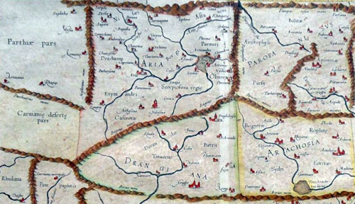
Bosworth writes that the name of the place where the victory was celebrated was Kahnuj. The name tells all, for Kanauj was the chief city of the29 Indians, the name of which is echoed in the famous city in eastern India which later became most important.
[29. A. B. Bosworth, Conquest and Empire: The Reign of Alexander the Great (Cambridge 1988) 150, who gives the name Khanu (maps usually give the name Kohnouj or Kahnuj). Nearby Patali may have been Palibothra.]
As the winter deepened, Alexander approached the Carmanian capital, which Diodorus (xvii.106.4) names Salmus. It was, according to Nearchus (Arr. Ind. 33.7), five days' journey from the coast. The site remains a mystery,386 but it was probably at the western side of the valley of the Halil Rud, in the general vicinity of the modern town of Khanu. The army was in an area of relative plenty but close enough to the coast to receive news of the progress of Nearchus' fleet. There Alexander sacrificed to commemorate his Indian victory and the emergence from the Gedrosian desert, and he held a musical and athletic festival, a drunken and festive affair, notable for the general acclaim achieved by Alexander's favourite Bagoas when he entered the winning chorus.387 During the celebrations, if not before, news came of Nearchus' safe arrival at Harmozeia, the principal seaport of Carmania. The details are supplied for us by Nearchus, and they are open to justifiable suspicion. Nearchus has a rich story, full of dramatic peripeteia, in which he unexpectedly learns of the king's presence in the near vicinity, marches up county with a small escort, strangely missing the search parties sent out by his anxious king, and is finally retrieved, unrecognisable from brine and fatigue, to give the glad news of the fleet's survival to Alexander in person. The details of this Odyssey are beyond verification and there is very probably a good deal of imaginative embellishment.388 What is certain is that the fleet arrived at Harmozeia without serious loss and that its arrival was announced to Alexander by Nearchus in person. It was a moment of general exaltation, and, if we may believe Nearchus (Arr. Ind. 36.3), Alexander renewed the sacrifices and prolonged the games. The celebrations which had begun commemorating the delivery of the army from Gedrosia ended with thanks-offerings for the safe arrival of the fleet.
-- A. B. Bosworth, Conquest and Empire: The Reign of Alexander the Great (Cambridge 1988), p. 150
Kahnuj (Persian: كهنوج, also Romanized as Kahnūj) is a city and capital of Kahnuj County, Kerman Province, Iran.
-- Kahnuj, by Wikipedia
***
Patali (Persian: پاتلي, also Romanized as Pātalī; also known as Kheyrābād-e Pātelī) is a village in Jahadabad Rural District, in the Central District of Anbarabad County, Kerman Province, Iran.
-- Patali, Anbarabad, by Wikipedia
Pataligram to Patna -- The Historical Journey Of The 'City of Flowers'
The cities, towns or villages that once occupied the site of modern Patna had carried quite a large number of names in different periods of history and most of them were in the name of 'FLOWERS.' The earliest to exist at the site seems to have been a small sprawling village with the name of Patali, Pataligrama, Padali or Padalipura as mentioned in Buddhist and Jain traditions.
Vayupurana mentions the name of Pataliputra as Kusumapura. In Tattvarthasutra of Umasvati, a celebrated Jain Author who lived here in the first-second centuries A.D., the place is described as Kusumapura. It literally means a 'city of flowers.' Gargi-Samhita names Pataliputra as Kusum-Dhvaja or Pushpapura -- variant of Kusumapura. The modern name of Phulwarisharif of a small hamlet near Patna is obviously a survival of the ancient name. One tradition says that in the time of Nandas, the name was Padmawati. It is under the Mauryans that the name of Pataliputra came in common use. Megasthenes, the Greek ambassador, at the court of Chandragupta Maurya, mentioned Pataliputra with the Greek utterance of 'Palibothra.' The celebrated Buddhist monk, Hiuen-Tsang who came to India in the seventh century A.D., also knew it by the name of Pataliputra.
-- The Wonder That Was Pataliputra, by brandingbihar.com
"Karavira, Jati, Champaka, Lotus, and Patali, are the five flowers (275)."
-- Mahanirvana Tantra: Tantra of the Great Liberation, Translated by Arthur Avalon (Sir John Woodroffe)
- admin
- Site Admin
- Posts: 41342
- Joined: Thu Aug 01, 2013 5:21 am
Re: Freda Bedi Cont'd (#3)
![]() by admin » Sat Sep 04, 2021 4:09 am
by admin » Sat Sep 04, 2021 4:09 am
Part 2 of 3
Smith is aware that Kanauj in eastern India was not the city mentioned in the ancient texts [??]; yet he does not suspect that the30 same could be true of Jones’ Palibothra. Dow identifies Sandrocottos with31 Sinsarchund who, according to Firista, ruled from Kanauj [Kinoge].
It is therefore clear that Alexander did not run away from the Prasii, as Badian imagines, but had in fact pursued Moeris, their leader, through Gedrosia. The palace at Kahnuj where Alexander rejoiced must have been the fabled one which, according to Aelian, excelled those at Susa and Ekbatana (Aelian, xiii.18).
Nearchus certainly had other tasks than scientific fact-finding; the army was ordered to keep close to the shore and the navy moved in tandem. This orchestration and the large number of troops and horses on ships (quite unnecessary for a scientific mission) show that the navy was not only carrying provisions for the army which was engaged in a grim and protracted battle with a mighty adversary, but that the troops on the ships were also ready to support the army if needed. This is why the navy waited for twenty-four days near Karachi. The names Pataliputra and Pattala and Moeris and Maurya leave little32 to imagination.
Yet Badian fails to recognise that Moeris was Chandragupta33 Maurya of Prasii; and his allusions to Alexander’s insanity, Dyonisius and Semiramis, et cetera are complete non-sequiturs from what can be legitimately inferred from available data. Badian has no idea that the food crisis was due to34 the collusion of Alexander’s officers with Moeris. As a general, Alexander can hardly be blamed for imposing a levy in order to arrange for the supplies for his army; this is the reason why the people of Pattala had fled. In his unseemly haste to cast Alexander in a stereotype, Badian overturns the whole episode and goes on to compare him with Chengiz Khan. Further clarifications in35 Alexander’s history come from an unexpected quarter – the history of Asoka.
Who Ruled Arachosia — Asoka the Saviour or Diodotus I Soter?
A powerful heuristic in artificial intelligence research is ‘coalesce’, which consists in assigning the same value to two different variables. In ancient 36 history also a similar approach at times leads to great simplification. It is not often that Soters rub shoulders with Saviours, but at first sight this is what seems to have happened in Arachosia. Macdonald writes:
That Asoka was the ruler of Arachosia is clear from his bilingual Kandahar38 edict; but curiously evidence from coins seems to suggest that the Indo-Greek39 king Diodotus I was the master of this area. To unravel this seemingly unsolvable mystery one has to delve deep into the persona of the two men. The picture of Asoka in the Indian sources is that of a fearsome warrior who later turned into a pious missionary king, a matchless propagator of Dhamma.40
Tradition has it that in his youth he had a very violent disposition and killed his elder brother Susima on his way to the throne. Indeed, in the thirteenth Rock41 Edict the Emperor himself recalls his enterprises with the sword, and admits that he found pleasure rather in conquests by the Dhamma than in conquests by the sword. In the edict, he writes that he had sent emissaries to distant kingdoms, including that of Epirus. The circumstance of a king of Patna writing to the King of Epirus, of all persons, is a jarring incongruity which under normal circumstances would have led the investigators to a valuable clue regarding the true identity of Asoka; but so stodgy was the prevailing scholarship that no one suspected that Jones’ identification Palibothra could be wrong. Even such a great scholar as Rhys Davids chooses to distrust the king’s account instead.42
The Ceylonese chronicles give the exaggerated story of his killing of ninety-nine brothers in his youth.
It is astonishing that the picture of Diodotus I has exactly the same mien. As already noted, the Mauryas ruled Aria and Seistan. This in a way opens up a Pandora’s box, for if Seistan and Aria were within the Mauryan kingdom it immediately follows that some of the Indo-Greek kings of Bactria and Seistan were Mauryas. Was Diodotus I a Maurya? Diodotus belonged to the same space and time as Asoka, and just like the latter he was a fierce warrior in his youth. An unsuspecting Macdonald writes:
The figure of Zeus wielding the thunderbolt in his coins is perhaps awesome, but there is much more to Diodotus than just brute power. On his gold and silver coins he sometimes calls himself Soter, ‘the saviour’. That he was regarded as a saviour long after his death is clear from the coins struck in his memory by the later Graeco-Bactrian kings Agathocles and Antimachus, which mention Diodotus Soter. The title has baffled all scholars. Tarn dismisses it as mere44 royal rhodomontade, but this is unwarranted. Narain also grapples with the45 problem, and gives the simplistic explanation that Diodotus I took the title Soter as he considered himself as the saviour of the Bactrian Greeks. Turning a blind46 eye to the very real likelihood that Diodotus the warrior may have transcended into a great missionary, Narain holds the myopic view that his name Theodotus (Theos = God) quoted by Justin (Justin, xli.4) was just a scribal error. The47 story of civilisation is replete with instances of fierce men and women who later responded to higher callings, but due to Jonesian delusions, writers like Holt48 have missed that the image of Diodotus wielding the thunderbolt is not at all irreconcilable with that of a Bodhisatva-like Soter spreading the message of homonoia. That the history of Asoka matches that of Diodotus I line by line can only imply that they were one and the same person.
Smith is aware that Kanauj in eastern India was not the city mentioned in the ancient texts [??]; yet he does not suspect that the30 same could be true of Jones’ Palibothra. Dow identifies Sandrocottos with31 Sinsarchund who, according to Firista, ruled from Kanauj [Kinoge].
It is affirmed, by the Brahmins, that it was in the time of this dynasty that the worship of emblematical figures of the divine attributes, was first established in India. The Persians, in their invasions, say they introduced the worship of the Sun, and other heavenly bodies, together with the proper symbol of God, the element of fire; but the mental adoration of the Divinity, as one Supreme Being, was still followed by many: The great city of Kinoge, so long the capital of Hindostan, was built by one of the Surajas, on the banks of the Ganges. The circumference of its walls are said to have been near one hundred miles.
Sirhind / Patiala / Delhi / Kannauj / "Pataliputra"
After the extinction or deposition of the royal house of Suraja, Baraja acceded to the throne of Hindostan, which he possessed thirty-six years. We know little concerning him, but that he built the city of Barage, still remaining in India. He had a genius for music, and wrote some books upon that subject, which were long in high repute. He, at last, grew disordered in his senses, became tyrannical, and was deposed by Keidar, a Brahmin, who assumed the empire.
Keidar, being a man of learning and genius, became an excellent prince. He paid the customary tribute to the King of Persia, and so secured his kingdom from foreign invasion. A domestic enemy, however, arose, that at length deprived him, in the nineteenth year of his reign, of his life and empire. This was Sinkol, a native of Kinoge, who breaking out into open rebellion, in Bengal and Behâr, defeated, in several battles, the imperial army, and mounted the throne.
Sinkol was a warlike and magnificent prince. He rebuilt the capital of Bengal, famous under the names of Lucknouti and Goura, and adorned it with many noble structures. Goura is said to have been the chief city of Bengal for two thousand years; and the ruins that still remain, prove that it has been an amazingly magnificent place. The unwholesomeness of the air prevailed upon the imperial family of Timur to order its being abandoned, and Tanda became the seat of government two hundred and fifty years ago.
Sinkol, keeping an immense army in pay, was induced to withhold the tribute from the King of Persia, and to turn the ambassador of that Monarch, with disgrace, from his court. Fifty thousand Persian horse, under their general, Peiran, invaded India, and advanced without much opposition to the confines of Bengal, where they came to battle with the imperial army, under Sinkol. Though the bravery of the Persians was much superior to that of the Hindoos, they were, at last, by the mere weight of numbers, driven from the field, and obliged to take shelter, in a strong post, in the neighbouring mountains, from whence the victors found it impossible to dislodge them. They continued to ravage the country, from their strong hold, and dispatched letters to Persia, to inform the King of their situation.
Affrasiab, for that, say the Brahmins, was the name of the monarch who reigned, in the days of Sinkol, over Persia and a great part of Tartary, was at the city of Gindis, near the borders of China, when he received intelligence of the misfortune of his army in India. He hastened to their relief with one hundred thousand horse, came to battle with the Emperor Sinkol, whom he totally defeated, and pursued to the capital of Bengal. Sinkol did not think it safe to remain long at that place, and therefore took refuge in the inaccessible mountains of Turhat. Affrasiab, in the mean time, laid waste the country with fire and sword. Sinkol thought it prudent to beg peace and forgiveness of Affrasiab, and he accordingly came, in the character of a suppliant, to the Persian camp, with a sword and a coffin carried before him, to signify that his life was in the disposal of the King. Sinkol was carried prisoner to Tartary, as an hostage for the obedience of his son Rohata, who was placed upon the throne of Hindostan.
Sinkol died in the 731 year before the Christian æra, and Rohata continued his reign over India. He was a wise, religious, and affable prince. The revenues of the empire, which extended from Kirmi to Malava [The Malavas or Malwas were an ancient Indian tribe. Modern scholars identify them with the Malloi who were settled in the Punjab region at the time of Alexander's invasion in the 4th century BCE. -- Malavas, by Wikipedia], he divided into three parts; one he expended in charities, another he sent to Persia, by way of tribute, and to support his father, and a third he appropriated to the necessary expences of government. The standing army of the empire was, upon this account, small, which encouraged the prince of Malava to revolt, and to support himself in his rebellion, Rohata built the famous fort of Rhotas, and left what remained to him of the empire, in peace, to his son. The race of Sinkol held the sceptre of India 81 years after his death, and then became extinct.
After a long dispute about the succession, a chief of the Raja-put tribe of Cutswa, assumed the dignities of the empire, under the name of Maraja. The first act of the reign of Maraja, was the reduction of Guzerat, where some disturbances had happened in the time of his predecessor. He built a port in that country, where he constructed vessels, and carried on commerce with all the states of Asia. He mounted the throne, according to the annals of India, in the 586 year before the birth of Christ, and reigned forty years. He is said to have been cotemporary with Gustasp, or Hystaspes, the father of Darius, who mounted the throne of Persia after the death of Smerdis. It is worthy of being remarked in this place, that the chronology of the Hindoos agrees, almost exactly, with that established by Sir Isaac Newton. Newton fixes the commencement of the reign of Darius in the 521 year before the Christian æra; so that, if we suppose that Hystaspes, who was governor of Turkestan, or Transoxiana, made a figure in Tartary twenty-five years before the accession of his son to the throne of Persia, which is no way improbable, the chronology of India agrees perfectly with that of Sir Isaac Newton.
Keda-raja, who was nephew, by a sister, to the former emperor, was nominated by him to the throne. Rustum Dista, the Persian governor of the ceded Indian provinces, being dead, Keda-raja turned his arms that way, reduced the countries upon the Indus, and fixed his residence in the city of Bera. The mountaineers of Cabul and Candahar, who are now called Afgans, or Patans, advanced against Keda-raja, and recovered all the provinces of which he had possessed himself upon the Indus. We know no more of the transactions of Keda-raja. He died after a reign of forty-three years.
Jei-chund, the commander in chief of Keda-raja's armies, found no great difficulty in mounting the throne after the death of his sovereign. We know little of the transactions of the reign of Jei-chund. A pestilence and famine happened in his time, and he himself was addicted to indolence and pleasure. He reigned sixty years, and his son succeeded him in the empire, but was dispossessed by Delu, the brother of Jei-chund. Bemin and Darâb, or Darius, say the Indians, were two successive Kings of Persia, in the days of Jei-chund, and he punctually paid to them the stipulated tribute.
Delu is said to have been a prince of uncommon bravery and generosity; benevolent towards men, and devoted to the service of God. The most remarkable transaction of his reign is the building of the city of Delhi, which derives its name from its founder, Delu. In the fortieth year of his reign, Phoor, a prince of his own family, who was governor of Cumaoon, rebelled against the Emperor, and marched to Kinoge, the capital. Delu was defeated, taken, and confined in the impregnable fort of Rhotas.
Phoor immediately mounted the throne of India, reduced Bengal, extended his power from sea to sea, and restored the empire to its pristine dignity. He died after a long reign, and left the kingdom to his son, who was also called Phoor, and was the same with the famous Porus, who fought against Alexander.
The second Phoor, taking advantage of the disturbances in Persia, occasioned by the Greek invasion of that empire under Alexander, neglected to remit the customary tribute, which drew upon him the arms of that conqueror. The approach of Alexander did not intimidate Phoor. He, with a numerous army, met him at Sirhind, about one hundred and sixty miles to the north-west of Delhi, and in a furious battle, say the Indian historians, lost many thousands of his subjects, the victory, and his life. The most powerful prince of the Decan, who paid an unwilling homage to Phoor, or Porus, hearing of that monarch's overthrow, submitted himself to Alexander, and sent him rich presents by his son. Soon after, upon a mutiny arising in the Macedonian army, Alexander returned by the way of Persia.
Sinsarchund, the same whom the Greeks call Sandrocottus, assumed the imperial dignity after the death of Phoor, and in a short time regulated the discomposed concerns of the empire. He neglected not, in the mean time, to remit the customary tribute to the Grecian captains, who possessed Persia under, and after the death of, Alexander. Sinsarchund, and his son after him, possessed the empire of India seventy years. When the grandson of Sinsarchund acceded to the throne, a prince named Jona, who is said to have been a grand-nephew of Phoor, though that circumstance is not well attested, aspiring to the throne, rose in arms against the reigning prince, and deposed him.
Jona was an excellent prince, endued with many and great good qualities. He took great pains in peopling and in cultivating the waste parts of Hindostan, and his indefatigable attention to the police of the country established to him a lasting reputation for justice and benevolence. Jona acceded to the throne of India little more than two hundred and sixty years before the commencement of the Christian æra; and, not many years after, Aridshere, whom the Greeks call Arsaces, possessing himself of the Eastern provinces of Persia, expelled the successors of Alexander, and founded the Parthian, or second Persian empire. Arsaces assumed the name of King about two hundred and fifty-six years before Christ, according to the writers of Greece, which perfectly agrees with the accounts of the Brahmins. Aridshere, or Arsaces, claimed and established the right of Persia to a tribute from the empire of India, and Jona, fearing his arms, made him a present of elephants and a vast quantity of gold and jewels. Jona reigned long after this transaction, in great tranquillity, at Kinoge; and he and his posterity together possessed the throne peaceably, during the space of ninety years.
Callian-chund, by what means is not certain, was in possession of the empire of Hindostan about one hundred and seventy years before the commencement of our æra. He was of an evil disposition, oppressive, tyrannical, and cruel. Many of the best families in Hindostan, to avoid his tyrannies, fled beyond the verge of the empire; so that, say the Brahmin writers, the lustre of the court, and the beauty of the country, were greatly diminished. The dependent princes at length took arms, and Callian-chund, being deserted by his troops, fled, and died in obscurity.
With him the empire of India may be said to have fallen. The princes and governors assumed independence, and though some great men, by their valour and conduct, raised themselves afterwards to the title of Emperors, there never was a regular succession of Kings. From the time of Callian-chund, the scanty records we have, give very little light in the affairs of India, to the time of Bicker-Majit, King of Malava, who made a great figure in that part of the world.
Bicker-Majit is one of the most renowned characters in Indian history. In policy, justice, and wisdom, they affirm that he had no equal. He is said to have travelled over a great part of the East, in the habit of a mendicant devotee, in order to acquire the learning, arts, and policy of foreign nations. It was not till after he was fifty years of age that he made a great figure in the field; and his uncommon success, justified, in some measure, a notion, that he was impelled to take arms by divine command. In a few months he reduced the kingdoms of Malava and Guzerat, securing with acts of justice and sound policy what his arms obtained. The poets of those days praise his justice, by affirming that the magnet, without his permission, durst not exert its power upon iron, nor amber upon the chaff of the field; and such was his temperance and contempt of grandeur, that he slept upon a mat, and reduced the furniture of his apartment to an earthen pot, filled with water from the spring. To engage the attention of the vulgar to religion, he set up the great image of Macâl, or Time, in the city of Ugein, which he built, while he himself worshipped only the infinite and invisible God.
The Hindoos retain such a respect for the memory of Bicker-Majit, that the most of them, to this day, reckon their time from his death, which happened in the 89th year of the Christian æra. Shawpoor, or the famous Sapor, king of Persia, is placed, in the Indian chronology, as cotemporary with this renowned king of Malava. He was slain in his old age, in a battle against a confederacy of the princes of the Decan.
The empire of Malava, after the demise of Bicker. Majit, who had raised it to the highest dignity, fell into anarchy and confusion. The great vassals of the crown assumed independence in their respective governments, and the name of Emperor was, in a great measure, obliterated from the minds of the people. One Raja-Boga, of the same tribe with Bicker-Majit, drew, by his valour, the reins of general government into his hands. He was a luxurious, though otherwise an excellent prince. His passion for architecture produced many magnificent fabrics, and several fine cities in Hindostan own him for their founder. He reigned in all the pomp of luxury, about fifty years, over a great part of India.
The ancient empire of Kinoge was in some measure revived by Basdeo, who, after having reduced Bengal and Behâr, assumed the imperial titles. He mounted the throne at Kinoge about 330 years after the birth of Christ, and reigned with great reputation. Byram-gore, king of Persia, came, in the time of Basdeo, to India, under the character of a merchant, to inform himself of the power, policy, manners, and government of that vast empire. This circumstance is corroborated by the joint testimonies of the Persian writers; and we must observe upon the whole, that, in every point, the accounts extracted from the Maha-barit agree with those of foreign writers, when they happen to treat upon the same subject: which is a strong proof, that the short detail it gives of the affairs of India is founded upon real facts. An accident which redounded much to the honour of Byram-gore brought about his being discovered. A wild elephant, in rutting-time, if that expression may be used, attacked him in the neighbourhood of Kinoge, and he pierced the animal's forehead with an arrow, which acquired to him such reputation, that the Emperor Basdeo ordered the merchant into his presence; where Byram-gore was known by an Indian nobleman, who had carried the tribute, some years before, to the court of Persia. Basdeo, being certainly assured of the truth, descended from his throne, and embraced the royal stranger.
Byram-gore being constrained to assume his proper character, was treated with the utmost magnificence and respect while he remained at the Indian court, where he married the daughter of Basdeo, and returned, after some time, into Persia. Basdeo and the princes, his posterity; ruled the empire in tranquillity for the space of eighty years.
Upon the accession of a prince of the race of Basdeo in his non-age, civil disputes arose, and those soon gave birth to a civil war. The empire being torn to pieces by civil dissensions, an assembly of the nobles thought it prudent to exclude the royal line from the throne, and to raise to the supreme authority Ramdeo, general of the imperial forces. Ramdeo was of the tribe of Rhator, the same with the nation, well known in India, under the name of Mahrators. He was a bold, wise, generous and good prince. He reduced into obedience the chiefs, who, during the distractions of the empire, had rendered themselves independent. He recovered the country of Marvar from the tribe of Cutswa, who had usurped the dominion of it, and planted it with his own tribe of Rhator, who remain in possession of Marvar to this day.
Ramdeo was one of the greatest princes that ever sat upon the throne of Hindostan. In the course of many successful expeditions, which took up several years, he reduced all India under his dominion, and divided the spoil of the vanquished princes among his soldiers. After a glorious reign of fifty-four years, he yielded to his fate; but the actions of his life, says our author, have rendered his name immortal. Notwithstanding his great power, he thought it prudent to continue the payment of the usual tribute to Feros-sassa, the father of the great Kei-kobâd, king of Persia.
After the death of Ramdeo, a dispute arose between his sons concerning the succession, which afterwards terminated in a civil war. Partab-chund, who was captain-general to the Emperor Ramdeo, taking advantage of the public confusions, mounted the throne, and, to secure the possession of it, extirpated the imperial family. Partab was cruel, treacherous and tyrannical. He drew by fair, but false promises, the princes of the empire from their respective governments, and, by cutting off the most formidable, rendered the rest obedient to his commands. An uninterrupted course of success made Partab too confident of his own power. He neglected, for some years, to send the usual tribute to Persia, returning, says our author, the ambassadors of the great Noshirwan, with empty hands, and dishonour, from his court. A Persian invasion, however, soon convinced Partab, that it was in vain to contend with the Lord Paramount of his empire. He was, in short, forced to pay up his arrears, to advance the tribute of the ensuing year, and to give hostages for his future obedience.
Partab mounted the imperial throne of India about the 500th year of Christ; and though he left the empire in the possession of his family, it soon declined in their hands. The dependent princes rendered themselves absolute in their respective governments; and the titular Emperor became so insignificant, with regard to power, that he gradually lost the name of Raja, or Sovereign, and had that of Rana substituted in its place. The Ranas, however, possessed the mountainous country of Combilmere, and the adjacent provinces of Chitor and Mundusir, till they were conquered by the Emperors of Hindostan of the Mogul race.
Soon after the death of Partáb-chund, Annindeo, a chief of the tribe of Bise, seized upon the extensive kingdom of Malava, and, with rapidity of conquest, brought the peninsula of Guzerat, the country of the Mahrattors, and the whole province of Berâr, into the circle of his command. Annindeo was cotemporary with Chusero Purvese, king of Persia; and he reigned over his conquests for sixteen years. At the same time that Annindeo broke the power of the empire, by his usurpation of the best of its provinces, one Maldeo, a man of an obscure original, raised himself into great power, and took the city of Delhi and its territory, from the imperial family. He soon after reduced the imperial city of Kinoge, which was so populous, that there were, within the walls, thirty thousand shops, in which arreca, a kind of nut, which the Indians use as Europeans do tobacco, was sold. There were also in Kinoge, sixty thousand bands of musicians and singers, who paid a tax to government. Maldeo, during the space of forty years, kept possession of his conquests, but he could not transmit them to his posterity. Every petty governor and hereditary chief in Hindostan rendered themselves independent, and the name of universal empire was lost, till it was established, by the Mahommedans, on the confines of India and Persia. The history of this latter empire comprehended the whole plan of Ferishta's annals; but to understand them properly, it may be necessary to throw more light, than he furnishes, upon the origin of that power which spread afterwards over all India.
-- The History of Hindostan, In Three Volumes, Volume I, by Alexander Dow, Esq., Lieutenant-Colonel in the Company's Service, 1812
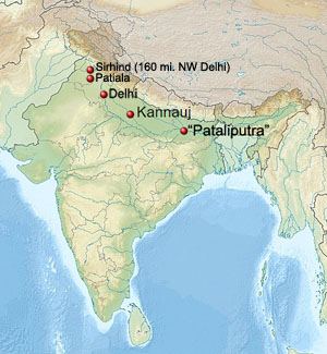
It is therefore clear that Alexander did not run away from the Prasii, as Badian imagines, but had in fact pursued Moeris, their leader, through Gedrosia. The palace at Kahnuj where Alexander rejoiced must have been the fabled one which, according to Aelian, excelled those at Susa and Ekbatana (Aelian, xiii.18).
The Royal Parks of India and Their Birds
18. In the royal residences in India where the greatest of the kings of that country lives, there are so many objects for admiration that neither Memnon's city of Susa with all its extravagance, nor the magnificence of Ecbatana is to be compared with them. (These places appear to be the pride of Persia, if there is to be any comparison between the two countries.) The remaining splendours it is not the purpose of this narrative to detail; but in the parks tame peacocks and pheasants are kept, and they <live> in the cultivated shrubs to which the royal gardeners pay due attention. Moreover there are shady groves and herbage growing among them, and the boughs are interwoven by the woodman's art. And what is more remarkable about the climate of the country, the actual trees are of the evergreen type, and their leaves never grow old and fall: some of them are indigenous, others have been imported from abroad after careful consideration. And these, the olive alone excepted, are an ornament to the place and enhance its beauty. India does not bear the olive of its own accord, nor if it comes from elsewhere, does it foster its growth.
Well, there are other birds besides, free and unenslaved, which come of their own accord and make their beds and resting-places in these trees. There too Parrots are kept and crowd around the king. But no Indian eats a Parrot in spite of their great numbers, the reason being that the Brahmins regard them as sacred and even place them above all other birds. And they add that they are justified in so doing, for the Parrot is the only bird that gives the most convincing imitation of human speech. There are also in these royal domains beautiful lakes, the work of man's hands, which contain fish of immense size and tame. And nobody hunts them, only the king's sons during their childhood; and in calm waters, quite free from danger, they fish and sport and even learn the art of sailing as well.
-- Aelian, Characteristics of animals, book XIII, Chapter 18
Nearchus certainly had other tasks than scientific fact-finding; the army was ordered to keep close to the shore and the navy moved in tandem. This orchestration and the large number of troops and horses on ships (quite unnecessary for a scientific mission) show that the navy was not only carrying provisions for the army which was engaged in a grim and protracted battle with a mighty adversary, but that the troops on the ships were also ready to support the army if needed. This is why the navy waited for twenty-four days near Karachi. The names Pataliputra and Pattala and Moeris and Maurya leave little32 to imagination.
Nearchos.
Among all the great men associated with Alexander no one has left a reputation more noble and unsullied than that of Nearchos. The long and difficult voyage in unknown seas which he successfully accomplished ranks as one of the greatest achievements in the annals of navigation. He was free from the mad ambition to rule which gave rise to the deadly feuds between Alexander’s other great generals, and stained the records of their lives with so many dark crimes. He was a native of Crete, but settled at Amphipolis, a Macedonian city near the Thracian border. He held a high position at the court of King Philip, where he attached himself to the party of the young prince, and was banished along with Ptolemy, Harpalos, and others, who had involved themselves in his intrigues. Alexander, on mounting the throne, recalled his former partisans, and did not neglect their interests. Nearchos accompanied him into Asia, where he was appointed governor of Lykia and other provinces south of the Tauros. This post he continued to hold for five years. He rejoined Alexander before he left Baktria to invade India, and in India he was appointed commander of the fleet which was built on the Hydaspes. He conducted it down that river and the Akesines and the Indus to Patala (now Haidarabad), a naval station at the apex of the Indus Delta. He arrived at that place about the time when the south-west monsoon usually sets in. Alexander, on returning to Patala from the excursions he made to the ocean, removed the fleet to Killouta, an island in the western branch of the Indus, which possessed a commodious haven. He then set out on his return to Persia, leaving the fleet with Nearchos, who had relieved Alexander’s mind of a load of anxiety by voluntarily proffering his services to conduct the expedition by sea to the head of the Persian Gulf. When we consider, as Bunbury remarks, the total ignorance of the Greeks at this time concerning the Indian seas, and the imperfect character of their navigation, it is impossible not to admire the noble confidence with which Nearchos ventured to promise that he would bring the ships in safety to the shores of Persia, “if the sea were navigable and the thing feasible for mortal man.” Nearchos wished to defer his departure till the monsoon had quite subsided, but as he was in danger of being attacked by the natives, who were no longer overawed by Alexander’s presence, he set sail on the 21st of September, 325 B.C.. He was forced, however, by the violence of the weather, when he had reached the mouth of the Indus, to take refuge in a sheltered bay at a station which he called Alexander’s Haven, and which is now known as Karachi, the great emporium of the trade of the Indus. After a detention here for twenty-four days, he resumed his voyage on the 23rd of October. Coasting the shore of the Arabies for 80 miles, he reached the mouth of the river Arabis (now the Purali), which divides the Arabies from the Oreitai. The coast of the latter people, which was 100 miles in extent, was navigated in eighteen days. At one of the landing-places the ships were supplied by Leonnatos with stores of corn, which lasted ten days. The navigation of the Mekran coast which succeeded occupied twenty days, and the distance traversed was 480 miles English, though Nearchos in his journal has set it down at 10,000 stadia or 1250 miles. The expedition in this part of the voyage suffered great distress for want of provisions. The coast was barren, and its savage inhabitants, the Ichthyophagi,1 [According to Dr. Bellew this name is the Greek equivalent of the Persian Mahikhoran, "fish-eaters,” still surviving in the modern Makran. (Since the above note was written the cause of Eastern learning and research has suffered a grievous loss by the death of this distinguished Orientalist, whose work on the Ethnology of Afghanistan will prove a lasting monument to his fame. The work discusses inter alia the ethnic affinities of the various races with which Alexander came into contact during his Asiatic expedition.)] had little else to subsist on than fish, which some of them ate raw.2 [Major E. Mockler, the political agent of Makran, contributed some years ago to the Journal of the Royal Asiatic Society a valuable paper on the identification of places on this coast mentioned by Arrian, Ptolemy, and Marcian, in which he corrected some errors into which the commentators on these authors had fallen.] The Karmanian coast, which succeeded, was not so distressingly barren, but was even, in certain favoured localities, extremely fertile and beautiful. Its length was 296 miles, and the time taken in its navigation was nineteen days, some of which, however, were spent at the mouth of the river Anamis (now the Minab), whence Nearchos made a journey into the interior to apprise Alexander of the safety of his fleet. The coasts of Persis and Sousis were navigated in thirty-one days. Nearchos had intended to sail up the Tigris, but having passed its mouth unawares, continued sailing westward till he reached Diridotis (Teredon), an emporium in Babylonia on the Pallocopas branch of the Euphrates. He thence retraced his course to the Tigris, and ascended its stream till he reached a lake through which at that time it flowed and which received the river Pasitigris, the Ulai of Scripture, and now the Karun. The fleet proceeded up this river till it met the army near a bridge on the highway from Persis to Sousa. It anchored at the bridge on the 24th of February, 324 B.C., so that the whole voyage was performed in 146 days. Nearchos received appropriate rewards for the splendid service he had so successfully performed. Alexander was sending him away on another great maritime expedition when the illness which carried off the great conqueror broke up the enterprise. In the discussions which followed regarding the succession to the throne, Nearchos unsuccessfully advocated the claims of Herakles, the son of Alexander by Barsine, who was the daughter of Artabazos and the widow of Memnon the Rhodian. He acquiesced, however, in the arrangements made by the other generals, and was content with receiving his former government, even though he was to hold it subject to the authority of Antigonos. He accompanied his superior when he marched against Eumenes, and interceded for the life of the latter when he fell into the hands of his enemies. Nothing is known of his history after the year 314 B.C., when he was selected by Antigonos to assist his son Demetrios with his counsels when left for the first time in command of an army.
-- The Invasion of India by Alexander the Great as described by Arrian Q. Curtius Diodorus Plutarch and Justin: Being Translations of Such Portions of the Works of These and Other Classical Authors as Describe Alexander's Campaigns in Afghanistan the Panjab Sindh Gedrosia and Karmania With An Introduction Containing a Life of Alexander, Copious Notes Illustrations Maps and Indices, by J.W. McCrindle M.A., Late Principal of the Government College Patna and Fellow of the Calcutta University Member of the General Council of the University of Edinburgh
Yet Badian fails to recognise that Moeris was Chandragupta33 Maurya of Prasii; and his allusions to Alexander’s insanity, Dyonisius and Semiramis, et cetera are complete non-sequiturs from what can be legitimately inferred from available data. Badian has no idea that the food crisis was due to34 the collusion of Alexander’s officers with Moeris. As a general, Alexander can hardly be blamed for imposing a levy in order to arrange for the supplies for his army; this is the reason why the people of Pattala had fled. In his unseemly haste to cast Alexander in a stereotype, Badian overturns the whole episode and goes on to compare him with Chengiz Khan. Further clarifications in35 Alexander’s history come from an unexpected quarter – the history of Asoka.
The first kings of the Dynasty of the Barhadrathas being omitted in the table, are given here from the Harivansa. The famous Uparichara was the sixth in lineal descent from Curu; and his son wasVrihadratha
Cushagra
Vrishabha
Pushpavan
Satyasahita
Urja
Sambhava
Jara-Sandha.
Jara-Sandha, literally old Sandha or Sandhas, was the lord paramount of India or Maha Raja, and in the spoken dialects Ma-Raj. This word was pronounced Morieis by the Greeks; for Hesychius says, that Morieis signifies king in India, and in another place, that Mai in the language of that country, signified great. Nonnus, in his Dionysiacs, calls the lord paramount of India, Morrheus, and says that his name was Sandes, with the title of Hercules. Old Sandha is considered as a hero to this day in India, and pilgrimages, I am told, are yearly performed to the place of his abode, to the cast of Gaya, in south Bahar, It is called Raja-Griha, or the royal mansion, in the low hills of Raja-giri, or the royal mountains; though their name I suspect to be derived from Raja-Griha The Dionysiacs of Nonnus are really the history of the Maha Bharata, or great war, as we shall see hereafter.
-- Essay III. Of the Kings of Magadha; their Chronology, by Captain Wilford, Asiatic Researches, Volume 9, 1809.
Who Ruled Arachosia — Asoka the Saviour or Diodotus I Soter?
A powerful heuristic in artificial intelligence research is ‘coalesce’, which consists in assigning the same value to two different variables. In ancient 36 history also a similar approach at times leads to great simplification. It is not often that Soters rub shoulders with Saviours, but at first sight this is what seems to have happened in Arachosia. Macdonald writes:
Who was the lord of Arachosia when it was traversed by the Seleucid troops, it is difficult to say. It had once been Asoka.37
That Asoka was the ruler of Arachosia is clear from his bilingual Kandahar38 edict; but curiously evidence from coins seems to suggest that the Indo-Greek39 king Diodotus I was the master of this area. To unravel this seemingly unsolvable mystery one has to delve deep into the persona of the two men. The picture of Asoka in the Indian sources is that of a fearsome warrior who later turned into a pious missionary king, a matchless propagator of Dhamma.40
Tradition has it that in his youth he had a very violent disposition and killed his elder brother Susima on his way to the throne. Indeed, in the thirteenth Rock41 Edict the Emperor himself recalls his enterprises with the sword, and admits that he found pleasure rather in conquests by the Dhamma than in conquests by the sword. In the edict, he writes that he had sent emissaries to distant kingdoms, including that of Epirus. The circumstance of a king of Patna writing to the King of Epirus, of all persons, is a jarring incongruity which under normal circumstances would have led the investigators to a valuable clue regarding the true identity of Asoka; but so stodgy was the prevailing scholarship that no one suspected that Jones’ identification Palibothra could be wrong. Even such a great scholar as Rhys Davids chooses to distrust the king’s account instead.42
Three languages were used, Prakrit, Greek and Aramaic. The edicts are composed in non-standardized and archaic forms of Prakrit. Prakrit inscriptions were written in Brahmi and Kharosthi scripts, which even a commoner could read and understand. The inscriptions found in the area of Pakistan are in the Kharoshthi script. Other Edicts are written in Greek or Aramaic. The Kandahar Greek Edict of Ashoka (including portions of Edict No.13 and No.14) is in Greek only, and originally probably contained all the Major Rock Edicts 1-14...
The Major Pillar Edicts of Ashoka refer to seven separate major Edicts inscribed on columns, the Pillars of Ashoka, which are significantly detailed and extensive.
These edicts are preceded chronologically by the Minor Rock Edicts and the Major Rock Edicts, and constitute the most technically elegant of the inscriptions made by Ashoka. They were made at the end of his reign, from the years 26 and 27 of his reign, that is, from 237-236 BCE. Chronologically they follow the fall of Seleucid power in Central Asia and the related rise of the Parthian Empire and the independent Greco-Bactrian Kingdom circa 250 BCE. Hellenistic rulers are not mentioned anymore in these last edicts, as they only appear in Major Rock Edict No.13 (and to a lesser extent Major Rock Edict No.2), which can be dated to about the 14th year of the reign of Ashoka circa 256–255. The last Major Pillar Edicts (Edict No.7) is testamental in nature, making a summary of the accomplishments of Ashoka during his life.….
Proselytism beyond India….Now, it is the conquest by the Dharma that the Beloved of the Gods considers as the best conquest. And this one (the conquest by the Dharma) was won here, on the borders, and even 600 yojanas (leagues) from here, where the king Antiochos reigns, and beyond where reign the four kings Ptolemy, Antigonos, Magas and Alexander [Alexander II of Epirus], likewise in the south, where live the Cholas, the Pandyas, and as far as Tamraparni.
— Extract from Major Rock Edict No.13.
It is not clear in Hellenic records whether these emissaries were actually received, or had any influence on the Hellenic world. But the existence of the edicts in a very high-level Greek literary and philosophical language testifies to the high sophistication of the Greek community of Kandahar, and to a true communication between Greek intellectuals and Indian thought. According to historian Louis Robert, it becomes quite likely that these Kandahar Greeks who were very familiar with Indian culture could in turn transmit Indian ideas to the philosophical circles of the Mediterranean world, in Seleucia, Antioch, Alexandria, Pella or Cyrene. He suggests that the famous Ashoka emissaries sent to the Western Hellenistic Courts according to Ashoka's Major Rock Edict No.13 were in fact Greek subjects and citizens of Kandahar, who had the full capacity to carry out these embassies.….
Proselytism within Ashoka's territories
Inside India proper, in the realm of Ashoka, many different populations were the object of the King's proselytism. Greek communities also lived in the northwest of the Mauryan empire, currently in Pakistan, notably ancient Gandhara, and in the region of Gedrosia, nowadays in Southern Afghanistan, following the conquest and the colonization efforts of Alexander the Great around 323 BCE. These communities therefore seem to have been still significant during the reign of Ashoka. The Kambojas are a people of Central Asian origin who had settled first in Arachosia and Drangiana (today's southern Afghanistan), and in some of the other areas in the northwestern Indian subcontinent in Sindhu, Gujarat and Sauvira. The Nabhakas, the Nabhapamkits, the Bhojas, the Pitinikas, the Andhras and the Palidas were other people under Ashoka's rule:Here in the king's domain among the Greeks, the Kambojas, the Nabhakas, the Nabhapamkits, the Bhojas, the Pitinikas, the Andhras and the Palidas, everywhere people are following Beloved-of-the-Gods' instructions in Dhamma.
-- Rock Edict No.13 (S. Dhammika)
-- Edicts of Ashoka, by Wikipedia
Epirus (/ɪˈpaɪrəs/) is a geographical and historical region in southeastern Europe, now shared between Greece and Albania. It lies between the Pindus Mountains and the Ionian Sea, stretching from the Bay of Vlorë and the Acroceraunian Mountains in the north to the Ambracian Gulf and the ruined Roman city of Nicopolis in the south. It is currently divided between the region of Epirus in northwestern Greece and the counties of Gjirokastër, Vlorë, and Berat in southern Albania. The largest city in Epirus is Ioannina, seat of the region of Epirus, with Gjirokastër the largest city in the Albanian part of Epirus.
A rugged and mountainous region, Epirus was the north-west area of ancient Greece. It was inhabited by the Greek tribes of the Chaonians, Molossians, and Thesprotians. It was home to the sanctuary of Dodona, the oldest oracle in ancient Greece, and the second most prestigious after Delphi. Unified into a single state in 370 BC by the Aeacidae dynasty, Epirus achieved fame during the reign of Pyrrhus of Epirus who fought the Roman Republic in a series of campaigns. Epirus subsequently became part of the Roman Republic along with the rest of Greece in 146 BC, which was followed by the Roman Empire and Eastern Roman Empire.
-- Epirus, by Wikipedia
The Ceylonese chronicles give the exaggerated story of his killing of ninety-nine brothers in his youth.
It is astonishing that the picture of Diodotus I has exactly the same mien. As already noted, the Mauryas ruled Aria and Seistan. This in a way opens up a Pandora’s box, for if Seistan and Aria were within the Mauryan kingdom it immediately follows that some of the Indo-Greek kings of Bactria and Seistan were Mauryas. Was Diodotus I a Maurya? Diodotus belonged to the same space and time as Asoka, and just like the latter he was a fierce warrior in his youth. An unsuspecting Macdonald writes:
The spectacle of the greatness of the Maurya empire would not be lost upon a satrap of such force of character as the elder Diodotus. 43
The figure of Zeus wielding the thunderbolt in his coins is perhaps awesome, but there is much more to Diodotus than just brute power. On his gold and silver coins he sometimes calls himself Soter, ‘the saviour’. That he was regarded as a saviour long after his death is clear from the coins struck in his memory by the later Graeco-Bactrian kings Agathocles and Antimachus, which mention Diodotus Soter. The title has baffled all scholars. Tarn dismisses it as mere44 royal rhodomontade, but this is unwarranted. Narain also grapples with the45 problem, and gives the simplistic explanation that Diodotus I took the title Soter as he considered himself as the saviour of the Bactrian Greeks. Turning a blind46 eye to the very real likelihood that Diodotus the warrior may have transcended into a great missionary, Narain holds the myopic view that his name Theodotus (Theos = God) quoted by Justin (Justin, xli.4) was just a scribal error. The47 story of civilisation is replete with instances of fierce men and women who later responded to higher callings, but due to Jonesian delusions, writers like Holt48 have missed that the image of Diodotus wielding the thunderbolt is not at all irreconcilable with that of a Bodhisatva-like Soter spreading the message of homonoia. That the history of Asoka matches that of Diodotus I line by line can only imply that they were one and the same person.
- admin
- Site Admin
- Posts: 41342
- Joined: Thu Aug 01, 2013 5:21 am
Who is online
Users browsing this forum: No registered users and 431 guests