Re: Freda Bedi, by Wikipedia
XIT Ranch
by Wikipedia
Accessed: 1/3/20
NOTICE: THIS WORK MAY BE PROTECTED BY COPYRIGHT
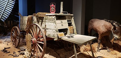
XIT Ranch chuck wagon, Panhandle Plains Historical Museum
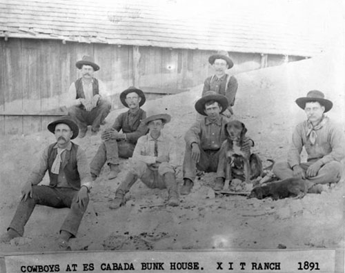
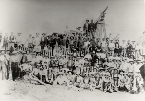
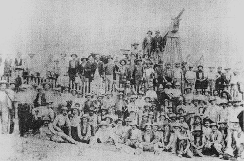
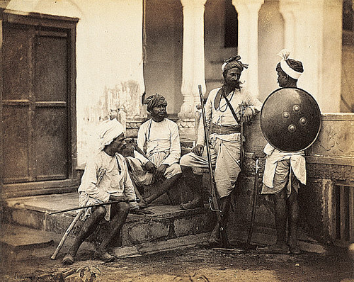
Cowboys at the XIT Ranch in 1891
The XIT Ranch was a cattle ranch in the Texas Panhandle which operated from 1885 to 1912. Comprising over 3,000,000 acres (12,000 km²) of land, it ran for 200 miles (300 km) along the border with New Mexico, varying in width from 20 to 30 miles (30 to 50 km). The massive ranch stretched through ten counties in Texas, and at its peak regularly handled 150,000 head of cattle.
History
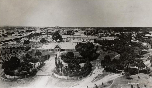
In 1879, the 16th Texas Legislature appropriated 3,000,000 acres (12,000 km²) of land to finance a new state capitol.[1] In 1882, in a special legislative session, the 17th Texas Legislature struck a bargain with Charles B. and John V. Farwell of Chicago, Illinois, under which a syndicate led by the Farwells, with mostly British investors, agreed to build a new Texas State Capitol in Austin and to accept the 3,000,000 acres (12,000 km²) of Panhandle land as payment.[2][3][4] The ranch stretched across all or portions of Dallam, Hartley, Oldham, Deaf Smith, Parmer, Castro, Bailey, Lamb, Cochran, and Hockley Counties.[1]
Total expense for the Capitol building materials and labor amounted to $3,744,630.60, of which the Syndicate Company paid $3,224,593.45. In return, they received 3,000,000 acres.[5]:53
Though Mathias Schnell won the contract for constructing the new building in January 1882, by May he had assigned all interest to Taylor, Babcock and Company. This company was composed of Col. Abner Taylor of Chicago, Col. A.C. Babcock of Canton, and John V. and Charles B. Farwell of Chicago. Abner Taylor was assigned company representative in June. Babcock inspected the Capitol Tract that same year, setting out from Tascosa on 23 March and arriving at the Yellow Houses on 27 April. His inspection noted the 1880 J.T. Munson survey, used to define the capitol lands, used the northwest boundary of the state defined by John H. Clark's 1859 survey. Clark's line defining the 103rd meridian, approved by Congress in 1891, turned out to be about one half mile west of the true meridian. The issue was not settled until John V. Farwell and President Taft were instrumental in passing a 16 Feb. 1911 joint resolution by Congress honoring the Clark line. This action saved Texas a strip of land one half mile wide and 310 miles long.[5]:52,57,59–67
In order to raise the capital needed to fence the ranch, build houses and barns, provide water, and purchase the cattle, John V. Farwell formed the Capitol Freehold Land and Investment Company, Limited, in London. The money was raised through the sale of debentures paying 5 percent interest. Directors of the company included John V. and Charles B. Farwell, Walter Potter, Henry Seton-Karr, Sir William Ewart, Edward M. Denny, Baron Thurlow, and the Marquis of Tweeddale, while the Earl of Aberdeen and Quintin Hogg were Trustees. The company existed until 1909, when all bonds had been redeemed,[5]:72–73
Company headquarters were located in the northern boundary of the ranch, at Buffalo Springs, with George Findlay directing business. Col. B.H. Campbell became general manager, and Berry Nations range foreman. The ranch started operations in 1885, purchasing cattle and moving them onto the ranch. By 1887, the herd was maintained at between 125,000 and 150,000, or about 20 acres per head. W.S. Mabry surveyed in the four-wire barbed wire fence line, and by 1886, 781 miles of fence were in place, including a 260 mile long west line and a 275 mile long east line. Cross fences were added by the late 1890s to make 94 pastures, bringing the total to 1500 miles of fence. A telephone line connected Tascosa to Alamocitos in 1888. Though the northern portion of the ranch had plenty of water near Buffalo Springs, the portion south of the Canadian River needed wells, which were also surveyed in by W.S. Mabry. By 1900, the ranch had 335 windmills averaging 34 feet high, with 12–18 foot wheels, producing water from an average depth of 125 feet. Additionally, 100 earthen dams were constructed. Trail driver Ab Blocker devised the XIT brand. The brand was simply made with a five inch long straight bar, applied five times. Yet, the XIT brand was not immune from "brand burning" by rustlers, which involved burning the original brand into another brand. Cowboy legends also kept alive the myth that the brand means "Ten In Texas." Each calf was branded with XIT on its side, the last numeral of the year on its shoulder, and the number of the division on its jaw.[5][2][1]
The ranch was initially divided into 7 division headquarters, located at (1) Buffalo Springs, (2) Middle Water, (3) Ojo Bravo, (4) Rito Blanco, (5) Escarbada, (6) Spring Lake, and (7) Yellow Houses, with (8) Bovina added later. Each was equipped with residences, cellars, bunkhouses, store rooms, barns, corrals, and two-wagon freight outfit. Large warehouses were maintained at Tascosa in 1887, after the introduction of the Fort Worth and Denver Railroad, and in Bovina, after it was connected to the J.J. Hagerman's Pecos Valley and Northeastern Railroad in 1898. General headquarters were moved to Channing in 1890. Each division wrote a monthly report and an annual report containing details about the cattle, range weather, and the men employed. Buffalo Springs became the steer ranch, Middle Water the cull ranch, while Ojo Bravo, Escarbada, Spring Lake and Yellow Houses became breeding ranges. The 10-12 cowboys working a division in the winter increased to 25-30 in the summer.[5]:97–98,147–150
Unfortunately, Campbell's management led to the ranch becoming a "stopping place and rendezvous for a large number of bad men and criminals," in the words of A.L. Matlock. Matlock was picked by John V. Farwell to run the ranch in 1887. Matlock chose A.G. Boyce as his general range manager.[5]:100–102,109
The Texas Trail was used for trail drives connecting Tascosa to Dodge City until 1885. Afterwards, the Northern Trail connected Buffalo Springs to the XIT range on Cedar Creek, 60 miles north of Miles City, Montana. That trail was used from 1886 until 1897. Over a period of 3 months, some 10,000 to 12,500 steers were moved from the Yellow Houses 1000 miles north to Cedar Creek. There they would graze for two years before being shipped to Chicago.[5]:126–128,136–137,141
Though the original stock consisted of Texas Longhorn cattle, in 1889, work started to improve the herd by introducing Hereford cattle and Polled Angus cattle. Registered herds were bought in 1892, and the Rito Blanco division bred the Angus, while the Escarbada, Spring Lake and Yellow Houses divisions bred the Herefords.[5]:182,187–190
Rules of the XIT Ranch
The XIT Ranch had 23 rules, on Abner Taylor's orders. They included prohibitions against carrying arms (No. 11); drinking alcohol (No. 15); and gambling (No. 12). Rule No. 22 stated the aim of the ranch was "sterling honesty and integrity".[1][5]:116,241–245
Sold off
The original plan of the Capitol Company was colonization, with ranching viewed as a temporary use of the land until farmers arrived. In 1890, Matlock began using an immigration agency, and 80,000 acres were prepared as farming tracts.[5]:71,205,211,224
Cattle prices crashed in 1886 and 1887, and in the fall of 1888, the ranch was unable to sell its cattle and make a profit. The ranch operated most years without showing any profit. Predators such as the Mexican wolf and cattle rustling led to further losses.[1]
In 1901, the ranch syndicate began selling off acreage to pay the Capitol Freehold Land and Investment Company, Limited, bonds. Large tracts were sold to cattlemen such as George W. Littlefield, who bought 235,858.5 acres of Yellow Houses in 1901. In 1904, the ranch started using land and development companies for wholesale purchases, but in 1905, 800,000 acres were also divided up into 160-640 acre tracts. Finally, in 1905, to prevent speculation, the syndicate established a land commissioner, and in 1915, a real estate trust. This trust, Capitol Reservations Lands, operated until 31 Dec. 1950. Yet, Capitol Mineral Rights Company retained much of the mineral rights.[5]:218–225
The family of Minnie Lou Bradley, who went on to establish the Bradley 3 Ranch in Childress County east of Amarillo, made large purchases of XIT land. Other purchasers included Texas cattlemen William E. Halsell, and John M. Shelton.[1]
Lee Bivins bought 70,000 acres from XIT's Capitol Syndicate. Located near Channing, Texas, the purchase included XIT headquarters.[6]
The last of the XIT cattle were sold on 1 Nov. 1912.[1][5]:217
Recognizing that their earlier surveys exceeded the stipulated areas by 2-4 percent, the state of Texas sued the Syndicate in 1918, claiming the excess was 57,840.5 acres. As a consequence, the state recovered 27,613.6 acres in Dallam County, and 30,226.9 acres in Hartley County.[5]:216–217
Legacy
In remembrance of the massive ranch, the City of Dalhart hosts the XIT Museum and the annual XIT Rodeo and Reunion held the first Thursday through Sunday of August. The celebration includes three days of junior and professional (PRCA) rodeo events, the world’s largest free barbecue, three nights of live music, a mud bog competition, an antique tractor-pull, and other activities.
Several businesses in the Dalhart area use "XIT" in their names and styles.
In popular culture
The Charles Ives song, "Charlie Rutlage," is about a poor XIT ranch hand who is killed. Cowboy artist Red Steagall song “6000 miles of wire” is about the forming of the XIT ranch.
See also
• Ira Aten
• Patrick H. Landergin
References
1. XIT Ranch from the Handbook of Texas Online; retrieved April 13, 2005.
2. Thumbnail History of the XIT Ranch; The XIT Museum website; retrieved March 20, 2009
3. "Fairlawn: The Farwell/McGann Estate at 965 East Deerpath" Biography of Charles B. Farwell; retrieved March 17, 2011
4. History of XIT Ranch; "My Turn;" Hidden Ancestors ; retrieved March 17, 2011
5. Haley, J. Evetts (1929). The XIT Ranch of Texas: And the Early Days of the Llano Estacado. Norman: University of Oklahoma Press. pp. 3, 75, 77, 83–88, 95–96, 106, 121–122, 149. ISBN 0806114282.
6. Archer, Jeanne; Taras, Stephanie (2009). Touching Lives: The Lasting Legacy of the Bivins Family. Tell Studios Inc. p. 41. ISBN 9780974914862.
Further reading
• Cordia Sloan Duke and Joe B. Frantz; 6,000 Miles of Fence: Life on the XIT Ranch of Texas; Austin: University of Texas Press; 1961.
External links
• The XIT Museum
• XIT Rodeo & Reunion
• Photos of the XIT Ranch hosted by the Portal to Texas History
by Wikipedia
Accessed: 1/3/20
NOTICE: THIS WORK MAY BE PROTECTED BY COPYRIGHT
YOU ARE REQUIRED TO READ THE COPYRIGHT NOTICE AT THIS LINK BEFORE YOU READ THE FOLLOWING WORK, THAT IS AVAILABLE SOLELY FOR PRIVATE STUDY, SCHOLARSHIP OR RESEARCH PURSUANT TO 17 U.S.C. SECTION 107 AND 108. IN THE EVENT THAT THE LIBRARY DETERMINES THAT UNLAWFUL COPYING OF THIS WORK HAS OCCURRED, THE LIBRARY HAS THE RIGHT TO BLOCK THE I.P. ADDRESS AT WHICH THE UNLAWFUL COPYING APPEARED TO HAVE OCCURRED. THANK YOU FOR RESPECTING THE RIGHTS OF COPYRIGHT OWNERS.
XIT Ranch chuck wagon, Panhandle Plains Historical Museum
Cowboys at the XIT Ranch in 1891
The XIT Ranch was a cattle ranch in the Texas Panhandle which operated from 1885 to 1912. Comprising over 3,000,000 acres (12,000 km²) of land, it ran for 200 miles (300 km) along the border with New Mexico, varying in width from 20 to 30 miles (30 to 50 km). The massive ranch stretched through ten counties in Texas, and at its peak regularly handled 150,000 head of cattle.
History
In 1879, the 16th Texas Legislature appropriated 3,000,000 acres (12,000 km²) of land to finance a new state capitol.[1] In 1882, in a special legislative session, the 17th Texas Legislature struck a bargain with Charles B. and John V. Farwell of Chicago, Illinois, under which a syndicate led by the Farwells, with mostly British investors, agreed to build a new Texas State Capitol in Austin and to accept the 3,000,000 acres (12,000 km²) of Panhandle land as payment.[2][3][4] The ranch stretched across all or portions of Dallam, Hartley, Oldham, Deaf Smith, Parmer, Castro, Bailey, Lamb, Cochran, and Hockley Counties.[1]
The Merriam Webster Dictionary defines syndicate as a group of people or businesses that work together as a team. This may be a council or body or association of people or an association of concerns, officially authorized to undertake a duty or negotiate business with an office or jurisdiction. It may mean an association of racketeers in organized crime.
-- Syndicate, by Wikipedia
In 1879 the Sixteenth Texas Legislature appropriated three million acres of land to finance a new state capitol building and appointed a Capitol Board (composed of the governor, comptroller, treasurer, attorney general, and land commissioner) to give the land to a contractor in exchange for building the Capitol. In 1881, after a fire destroyed the limestone Capitol, in Austin, which served the Republic from 1839 to 1842 and the state from 1845 to 1852, the state government pushed forward its plans to build a new Capitol. First, the Capitol Board hired architect Elijah E. Myers for $12,000 after he won the building commission’s design competition in 1881. Next, Mathias Schnell accepted the contract in return for the land. Schnell later transferred three-fourths interest to Taylor, Babcock, and Company of Chicago, which organized the Capitol Syndicate. The land that the syndicate was to receive as payment was in the unsettled Panhandle, so the syndicate established the XIT Ranch to make the most of the land until it could be sold.
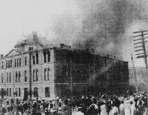
Myers modeled the Texas Capitol after the National Capitol, using a Renaissance Revival design. His plans called for native limestone, but Myers agreed to use red granite donated by the owners of Granite Mountain instead. Because red granite is harder than limestone, Myers modified his plans and eliminated the original design’s elaborate carvings. Myers, however, suffered from psychosomatic illnesses, which made him so difficult to work with that he was fired in 1886.
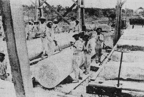
Construction began in 1882, and eventually Gustav Wilke, a Chicago builder, took over the massive project. Because the red granite was so expensive to transport and work with, the state stepped in, constructing a railroad from Granite Mountain to Burnet and providing convict labor. In 1885 union laborers—angry about the use of convict labor and the low wages Wilke offered—boycotted, and Wilke sent a representative to Scotland to contract granite cutters. The U.S. government indicted Wilke in 1886 for violating the Alien Contract Labor Law and fined him $64,000, which equaled $1,000 for each laborer imported.
-- Texas History 101: The Capitol Building's history is as colorful as its exterior, by TexasMonthly, June 30, 2003
Total expense for the Capitol building materials and labor amounted to $3,744,630.60, of which the Syndicate Company paid $3,224,593.45. In return, they received 3,000,000 acres.[5]:53
Though Mathias Schnell won the contract for constructing the new building in January 1882, by May he had assigned all interest to Taylor, Babcock and Company. This company was composed of Col. Abner Taylor of Chicago, Col. A.C. Babcock of Canton, and John V. and Charles B. Farwell of Chicago. Abner Taylor was assigned company representative in June. Babcock inspected the Capitol Tract that same year, setting out from Tascosa on 23 March and arriving at the Yellow Houses on 27 April. His inspection noted the 1880 J.T. Munson survey, used to define the capitol lands, used the northwest boundary of the state defined by John H. Clark's 1859 survey. Clark's line defining the 103rd meridian, approved by Congress in 1891, turned out to be about one half mile west of the true meridian. The issue was not settled until John V. Farwell and President Taft were instrumental in passing a 16 Feb. 1911 joint resolution by Congress honoring the Clark line. This action saved Texas a strip of land one half mile wide and 310 miles long.[5]:52,57,59–67
In order to raise the capital needed to fence the ranch, build houses and barns, provide water, and purchase the cattle, John V. Farwell formed the Capitol Freehold Land and Investment Company, Limited, in London. The money was raised through the sale of debentures paying 5 percent interest. Directors of the company included John V. and Charles B. Farwell, Walter Potter, Henry Seton-Karr, Sir William Ewart, Edward M. Denny, Baron Thurlow, and the Marquis of Tweeddale, while the Earl of Aberdeen and Quintin Hogg were Trustees. The company existed until 1909, when all bonds had been redeemed,[5]:72–73
Company headquarters were located in the northern boundary of the ranch, at Buffalo Springs, with George Findlay directing business. Col. B.H. Campbell became general manager, and Berry Nations range foreman. The ranch started operations in 1885, purchasing cattle and moving them onto the ranch. By 1887, the herd was maintained at between 125,000 and 150,000, or about 20 acres per head. W.S. Mabry surveyed in the four-wire barbed wire fence line, and by 1886, 781 miles of fence were in place, including a 260 mile long west line and a 275 mile long east line. Cross fences were added by the late 1890s to make 94 pastures, bringing the total to 1500 miles of fence. A telephone line connected Tascosa to Alamocitos in 1888. Though the northern portion of the ranch had plenty of water near Buffalo Springs, the portion south of the Canadian River needed wells, which were also surveyed in by W.S. Mabry. By 1900, the ranch had 335 windmills averaging 34 feet high, with 12–18 foot wheels, producing water from an average depth of 125 feet. Additionally, 100 earthen dams were constructed. Trail driver Ab Blocker devised the XIT brand. The brand was simply made with a five inch long straight bar, applied five times. Yet, the XIT brand was not immune from "brand burning" by rustlers, which involved burning the original brand into another brand. Cowboy legends also kept alive the myth that the brand means "Ten In Texas." Each calf was branded with XIT on its side, the last numeral of the year on its shoulder, and the number of the division on its jaw.[5][2][1]
The ranch was initially divided into 7 division headquarters, located at (1) Buffalo Springs, (2) Middle Water, (3) Ojo Bravo, (4) Rito Blanco, (5) Escarbada, (6) Spring Lake, and (7) Yellow Houses, with (8) Bovina added later. Each was equipped with residences, cellars, bunkhouses, store rooms, barns, corrals, and two-wagon freight outfit. Large warehouses were maintained at Tascosa in 1887, after the introduction of the Fort Worth and Denver Railroad, and in Bovina, after it was connected to the J.J. Hagerman's Pecos Valley and Northeastern Railroad in 1898. General headquarters were moved to Channing in 1890. Each division wrote a monthly report and an annual report containing details about the cattle, range weather, and the men employed. Buffalo Springs became the steer ranch, Middle Water the cull ranch, while Ojo Bravo, Escarbada, Spring Lake and Yellow Houses became breeding ranges. The 10-12 cowboys working a division in the winter increased to 25-30 in the summer.[5]:97–98,147–150
Unfortunately, Campbell's management led to the ranch becoming a "stopping place and rendezvous for a large number of bad men and criminals," in the words of A.L. Matlock. Matlock was picked by John V. Farwell to run the ranch in 1887. Matlock chose A.G. Boyce as his general range manager.[5]:100–102,109
The Texas Trail was used for trail drives connecting Tascosa to Dodge City until 1885. Afterwards, the Northern Trail connected Buffalo Springs to the XIT range on Cedar Creek, 60 miles north of Miles City, Montana. That trail was used from 1886 until 1897. Over a period of 3 months, some 10,000 to 12,500 steers were moved from the Yellow Houses 1000 miles north to Cedar Creek. There they would graze for two years before being shipped to Chicago.[5]:126–128,136–137,141
Though the original stock consisted of Texas Longhorn cattle, in 1889, work started to improve the herd by introducing Hereford cattle and Polled Angus cattle. Registered herds were bought in 1892, and the Rito Blanco division bred the Angus, while the Escarbada, Spring Lake and Yellow Houses divisions bred the Herefords.[5]:182,187–190
Rules of the XIT Ranch
The XIT Ranch had 23 rules, on Abner Taylor's orders. They included prohibitions against carrying arms (No. 11); drinking alcohol (No. 15); and gambling (No. 12). Rule No. 22 stated the aim of the ranch was "sterling honesty and integrity".[1][5]:116,241–245
Sold off
The original plan of the Capitol Company was colonization, with ranching viewed as a temporary use of the land until farmers arrived. In 1890, Matlock began using an immigration agency, and 80,000 acres were prepared as farming tracts.[5]:71,205,211,224
Cattle prices crashed in 1886 and 1887, and in the fall of 1888, the ranch was unable to sell its cattle and make a profit. The ranch operated most years without showing any profit. Predators such as the Mexican wolf and cattle rustling led to further losses.[1]
In 1901, the ranch syndicate began selling off acreage to pay the Capitol Freehold Land and Investment Company, Limited, bonds. Large tracts were sold to cattlemen such as George W. Littlefield, who bought 235,858.5 acres of Yellow Houses in 1901. In 1904, the ranch started using land and development companies for wholesale purchases, but in 1905, 800,000 acres were also divided up into 160-640 acre tracts. Finally, in 1905, to prevent speculation, the syndicate established a land commissioner, and in 1915, a real estate trust. This trust, Capitol Reservations Lands, operated until 31 Dec. 1950. Yet, Capitol Mineral Rights Company retained much of the mineral rights.[5]:218–225
The family of Minnie Lou Bradley, who went on to establish the Bradley 3 Ranch in Childress County east of Amarillo, made large purchases of XIT land. Other purchasers included Texas cattlemen William E. Halsell, and John M. Shelton.[1]
Lee Bivins bought 70,000 acres from XIT's Capitol Syndicate. Located near Channing, Texas, the purchase included XIT headquarters.[6]
The last of the XIT cattle were sold on 1 Nov. 1912.[1][5]:217
Recognizing that their earlier surveys exceeded the stipulated areas by 2-4 percent, the state of Texas sued the Syndicate in 1918, claiming the excess was 57,840.5 acres. As a consequence, the state recovered 27,613.6 acres in Dallam County, and 30,226.9 acres in Hartley County.[5]:216–217
Legacy
In remembrance of the massive ranch, the City of Dalhart hosts the XIT Museum and the annual XIT Rodeo and Reunion held the first Thursday through Sunday of August. The celebration includes three days of junior and professional (PRCA) rodeo events, the world’s largest free barbecue, three nights of live music, a mud bog competition, an antique tractor-pull, and other activities.
Several businesses in the Dalhart area use "XIT" in their names and styles.
In popular culture
The Charles Ives song, "Charlie Rutlage," is about a poor XIT ranch hand who is killed. Cowboy artist Red Steagall song “6000 miles of wire” is about the forming of the XIT ranch.
See also
• Ira Aten
• Patrick H. Landergin
References
1. XIT Ranch from the Handbook of Texas Online; retrieved April 13, 2005.
2. Thumbnail History of the XIT Ranch; The XIT Museum website; retrieved March 20, 2009
3. "Fairlawn: The Farwell/McGann Estate at 965 East Deerpath" Biography of Charles B. Farwell; retrieved March 17, 2011
4. History of XIT Ranch; "My Turn;" Hidden Ancestors ; retrieved March 17, 2011
5. Haley, J. Evetts (1929). The XIT Ranch of Texas: And the Early Days of the Llano Estacado. Norman: University of Oklahoma Press. pp. 3, 75, 77, 83–88, 95–96, 106, 121–122, 149. ISBN 0806114282.
6. Archer, Jeanne; Taras, Stephanie (2009). Touching Lives: The Lasting Legacy of the Bivins Family. Tell Studios Inc. p. 41. ISBN 9780974914862.
Further reading
• Cordia Sloan Duke and Joe B. Frantz; 6,000 Miles of Fence: Life on the XIT Ranch of Texas; Austin: University of Texas Press; 1961.
External links
• The XIT Museum
• XIT Rodeo & Reunion
• Photos of the XIT Ranch hosted by the Portal to Texas History