Re: Freda Bedi, by Wikipedia
Nain Singh Rawat
by Wikipedia
Accessed: 2/4/20
Nain Singh Rawat
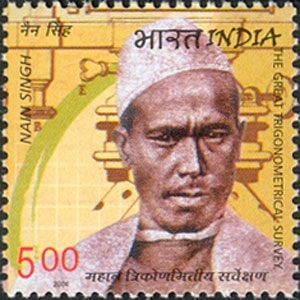
Nain Singh Rawat on a 2004 stamp of India
Born: 21 October 1830, Milam Village
Died: 1 February 1882, Moradabad
Nationality: Indian
Occupation: Asian explorer
Nain Singh Rawat (21 October 1830 – 1 February 1882),[1][2] was one of the first of the late 19th century Indian explorers (pundits) who explored the Himalayas for the British. He hailed from the Johar Valley of Kumaon. He surveyed the trade route through Nepal to Tibet, determined for the first time the location[3] and altitude of Lhasa, and surveyed a large section of the Brahmaputra. He walked "1,580 miles, or 3,160,000 paces, each counted."[3]
Early life
Rai Bahadur Nain Singh Rawat was born to Lata Burha in 1830 in Milam village, a Bhotia village at the foot of the Milam glacier where the river Goriganga originates in the valley of Johar now on India-China border now in present day Pithoragarh district of Uttarakhand state of India. The Rawats ruled over the Johar valley, during the reign of Chand dynasty in Kumaon; this was followed by the Gorkha rule. In 1816 the British defeated the Gorkhas but maintained a policy of non-interference and friendship towards the Johar Bhotias. The famous Bhotia explorers mostly belong to the village of Johar.
After leaving school, Nain Singh helped his father. He visited different centres in Tibet with him, learned the Tibetan language, customs and manners and became familiar with the Tibetan people. This knowledge of Tibetan language and local customs and protocol came in handy in Nain Singh's work as a "spy explorer". Due to the extreme cold conditions, Milam and other villages of the upper Johar valley are inhabited only for a few months from June to October. During this time the men used to visit Gya'nyima, Gartok and other markets in Western Tibet.
During his secret survey of Tibet, Nain Singh was the first non-Tibetan to visit many legendary areas of Tibet, including the Thok Jalung goldfields on 26 August 1867.[4] He would later say that Thok Jalung was the coldest place he had ever visited.[5]
Nain Singh was a cousin of Krishna Singh Rawat (1850-1921), also an explorer and cartographer, who was first to map the Ramgarh crater on a finer scale of (1 : 63,360).[6]
Legacy
On 27 June 2004, an Indian postage stamp featuring Nain Singh[7] was issued commemorating his role in the Great Trigonometric Survey. In 2006, Shekhar Pathak and Uma Bhatt brought out a biography of Nain Singh with three of his diaries and the RGS articles about his travels in three volumes titled Asia ki Peeth Par published by Pahar, Naini Tal.
The Nain Singh Range of mountains south of Lake Pangong are named in Nain's honour.[8]
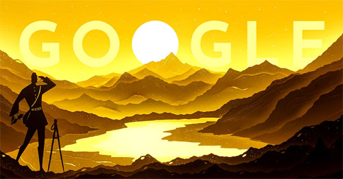
On 21 October 2017, Google celebrated Nain Singh Rawat's 187th birthday with a Google Doodle.[2]
See also
• Shauka - Johar
• Krishna Singh Rawat
• Mani Singh Rawat
• Cartography of India
Notes
1. The dates are tentative. The date of birth is based on the Google Doodle. The date of death is based on an obituary letter where Col. Edmund Smyth notes in April 1882 that Nain Singh died of Cholera at Moradabad around the "1st of February last". He mentions an obituary in "the Times" dated 15 March.
2. "Nain Singh Rawat's 187th birthday". http://www.google.com. Retrieved 20 October 2017.
3. Wade., Davis (2012). Into the Silence : The Great War, Mallory, and the Conquest of Everest. New York: Vintage Books. p. 49. ISBN 9780375708152. OCLC 773021726. The pundit Nain Singh, the first surveyor to fix the location of the Tibetan capital, traveled on foot from Sikkim to Lhasa and then all over central Tibet, walking 1,580 miles, or 3,160,000 paces, each counted.
4. "Nain Singh Rawat's 187th birthday". Google. Alphabet. Retrieved 24 April 2019.
5. Hopkirk, p. 39.
6. BALASUNDARAM, M., DUBE, A. Ramgarh, 1973, "Structure, India", Nature (journal), 242, 40 doi:10.1038/242040a0.
7. Trigonometrical Survey. midco.net
8. Waller, p. 121.
References
• Montgomerie, T. G. (1868a). "Report of a Route-Survey Made by Pundit, from Nepal to Lhasa, and Thence Through the Upper Valley of the Brahmaputra to Its Source". The Journal of the Royal Geographical Society of London. 38: 129–219. doi:10.2307/1798572. JSTOR 1798572.
• Montgomerie, T. G. (1868b). "Report of the Trans-Himalayan Explorations during 1867". Proceedings of the Royal Geographical Society of London. 13 (3): 183–198. doi:10.2307/1798932. JSTOR 1798932.
• Montgomerie, T. G. (1869). "Report of the Trans-Himalayan Explorations during 1867". The Journal of the Royal Geographical Society of London. 39: 146–187. doi:10.2307/1798550. JSTOR 1798550.
• Trotter, H. (1876). "Account of the Pundit's Journey in Great Tibet from Leh in Ladákh to Lhása, and of His Return to India viâ Assam". Proceedings of the Royal Geographical Society of London. 21 (4): 325–350. doi:10.2307/1799962. JSTOR 1799962.
• "Presentation of the Royal and Other Awards". Proceedings of the Royal Geographical Society of London. 21 (5): 397–403. 1876. JSTOR 1799720.
• Smyth, Edmund (1882). "Obituary: The Pundit Nain Singh". Proceedings of the Royal Geographical Society and Monthly Record of Geography. 4 (5): 315–317. JSTOR 1800228.
• Mason, Kenneth (1923). "Kishen Singh and the Indian Explorers". The Geographical Journal. 62 (6): 429–440. doi:10.2307/1781169. JSTOR 1781169.
• Waller, D. (2015) The Pundits: British Exploration of Tibet and Central Asia, University Press of Kentucky: Lexington, Kentucky. ISBN 9780813149042.
External links
• A Nain Singh anecdote
• Chapter from The Pundits: British exploration of Tibet and Central Asia by Derek Waller
• Nain Singh Rawat – The Indian explorer who explored the Himalayas
*******************************************
Explorer, Path Breaker, Spy: 16 Things About the Legendary Nain Singh Rawat
Born in 1830 in Milam, a village nestled in the valleys of the Kumaon Hills, the man’s ‘spy’ expedition proved to be a game changer in a time when the exploration game was a clear monopoly of the Europeans.
by Lekshmi Priya S
The Better India
October 21, 2017
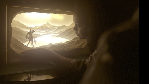
The Google Doodle by Hari and Deepti Panicker. Source: Google.
Today’s Google Doodle features Nain Singh Rawat, celebrating the 187th birth anniversary of the fearsome Indian explorer who surveyed the vast unexplored expanses of Tibet in the late 19th century.
But did you know that the man was the first person in the world to do that, besides determining the exact location and altitude of Lhasa, mapping the Tsangpo, and finally, bringing the fabled gold mines of Thok Jalung to world’s notice?
Born in 1830 in Milam, a village nestled in the valleys of the Kumaon Hills, the man’s ‘spy’ expedition proved to be a game changer in a time when the exploration game was a clear monopoly of the Europeans.
Here’s everything you need to know about the legendary explorer whose name continues to elicit nothing less of than admiration in the wide circles of exploration:
1. Rai Bahadur Nain Singh Rawat was born in a Shauka village located in the valley of Johar in Kumaon Hills, which is famous for being the home of Bhotia explorers from the British Era.
2. After leaving school, Nain Singh helped his father and visited different centres in Tibet with him. In the process, not only did he learn the Tibetan language, but also comprehended the customs and mannerisms practised by the local people, which would prove to be extremely beneficial in years to follow.
3. In 1855, a 25-year-old Nain Singh was first recruited by German geographers, the Schlagintweit brothers. The German scientists had approached the office of the Survey of India, which reluctantly allowed them to proceed with their survey.
4. Following which, along with three members of his family, Nain Singh set afoot on his first exploration trip between 1855 and 1857 and travelled to Lakes Manasarovar and Rakas Tal and then further to Gartok and Ladakh.
5. After the exploration with the German brothers, Nain Singh Rawat joined the Education Department and was appointed as the headmaster of a government vernacular school in his village at Milam from 1858 to 1863.
6. In 1863, Nain Singh Rawat and his cousin, Mani Singh Rawat, were selected and sent to the Great Trigonometrical Survey office in Dehradun where they underwent training for two years. This included training on the use of scientific instruments and ingenious ways of measuring and recording and the art of disguise.
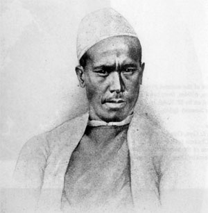
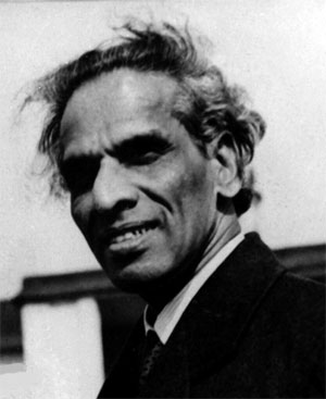
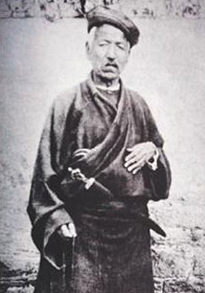
The legendary explorer, Nain Singh Rawat. Source: History Nuggets.
7. Being exceptionally intelligent, Nain Singh Rawat quickly learned the correct use of scientific instruments like the sextant and compass and could easily recognise all major stars and different constellations easily.
8. Part of the secret ‘spy’ exploration mission, he had donned the guise of a Tibetan Monk and walked from his home region of Kumaon to places as far as Kathmandu, Lhasa, and Tawang. He was trained to maintain a precisely measured pace, which included covering one mile in 2000 steps, and measuring those steps using a modified Buddhist rosary or mala.
9. Several other ingenious methods were devised, where the notes of measurements were coded in the form of written prayers, and these scrolls of paper were hidden in the cylinder of the prayer wheel to escape notice during the secret missions.
10. Collecting intelligence under the most testing conditions, he travelled closely with the local population in caravans and thus followed some of the most fascinating accounts in the history of exploration, which led Nain Singh to map the vast expanses of Tibet and its river systems.
11. In 1865, Nain Singh left the Trigonometrical Survey and head out for Nepal with Mani Singh. While Mani returned to India soon, Nain went on to explore Tashilhunpo, where he met the Panchen Lama, and later Lhasa, where he met the Dalai Lama.
12. During his stay in Lhasa, his true identity was discovered by two Kashmiri Muslim merchants. Interestingly, they did not report him to the authorities and on the contrary, lent him a small sum of money against the pledge of his watch.
On 27 June 2004, an Indian postage stamp featuring Nain Singh was issued commemorating his role in the Great Trigonometric Survey. Source: EUttarakhand.
13. On his second voyage, in 1867, Singh explored western Tibet and stumbled across the fabled gold mines of Thok Jalung. He was also blown away by the humility of the workers, who only dug for gold near the surface, as they believed that digging deeper was a crime against the Earth and would deprive it of its fertility.
14. His last and greatest journey was completed between the years 1873 and 1875, where he travelled from Leh in Kashmir to Lhasa, by a route more northerly than the one along the Tsangpo that he had taken on his first journey.
15. In recognition of his stupendous feats of exploration, Nain Singh was presented with an inscribed gold chronometer by the Royal Geographic Society (RGS) in 1868. According to Colonel Henry Yule, “his explorations had added a larger amount of important knowledge to the map of Asia than any other living man”.
16. Nain Singh was also conferred with the award of the Victoria or Patron’s Medal of the RGS in 1877 along with an inscribed watch by the Society of Geographers of Paris. In recognition of his fabulous achievements, the erstwhile government of India honoured the man with a land-grant of two villages.
Work in Progress. Source: Google.
The doodle art is a silhouette diorama illustration by paper cut artists Hari and Deepti Panicker, portraying Nain Singh Rawat as he might have looked on his travels — solitary and courageous, looking back over the distances he had walked, rosary beads in hand, and staff by his side.
************************
Krishna Singh Rawat [Kishen Singh] [Kishan Singh Milamwal] [Rai Bahadur]
by Wikipedia
Accessed: 2/4/20
Krishna Singh Rawat, also known as Kishen Singh, Kishan Singh Milamwal and titled as Rai Bahadur, (1850-1921) was an Indian explorer and cartographer, was styled as a pundit - a title used by the British for the native surveyors who worked for the "Survey of India".[1][2][3]
Early Life
He was born to a trader named Deb Singh Rawat. He was born at Milam village on India-China border now in present day Pithoragarh district. His elder brother was Mani Singh Rawat. His cousin Nain Singh Rawat was his also an explorer.[4][5] [6]
Education (1862-1867)
He simultaneous studied and worked as assistant at "Garbyang government school" in Dharchula area and progressed to later obtain the "Tehsil Mudarisi" diploma from "Normal School" at Almora. He taught at "Milam Girl’s School" and "Garbyang government school".[7][5][6]
Explorer (1867-1885)
He was hired and trained by the Geological Survey of India's Dehradun office, after which he participated in Great Trigonometrical Survey, and later even became a trainer for the survey. James Walker (Surveyor General) took him and his cousin Kishan Singh Rawat on expeditions of Tibet and Central Asia. He was part of the several important expeditions listed below.[8][9][1][10]
1. • 1869 Kailash-Mansarovar expedition.
2. • 1871-1872 Shigache–Lhasa expedition.
3. • 1873-1874 Yarkand–Kashgar expedition, second expedition of this area by Sir Thomas Douglas Forsyth.
4. • 1878-1882 Darjeeling–Lhasa–Mongolia expedition, stayed in Lahsa for a year masquerading as a merchant, surveyed Mekong, Salween, and Irrawaddy rivers.
He was also the first person to map the Ramgarh crater on a finer scale of (1 : 63,360).[11]
Retirement and Death (1885-1921)
He retired in 1885. In 1913 he became a guardian patron of "Johar Upkarini Mahasabha" grassroot development co-operative society of Johar valley. He passed away in February 1921.[2][3]
Retirement and Honors
He received the following:[1][2][3]
1. Royal Geographic Society, honored him with an inscribed gold watch and 500 Indian rupees.
2. Paris Geographical Society, a gold medal.
3. Italian Geographic Society, a gold medal.
4. British government of India, title of Rai Bahadur.
5. British government of India: with a grant of jagir by British in Sitapur district of present day Uttar Pradesh with annual revenue of INR1850.
See also
• Garhwali people
• Kumauni people
• Shauka - Johar
• List of explorers
• Cartography of India
References
Citations
1. Derek J. Waller, 2004, "The Pundits: British Exploration of Tibet and Central Asia," University Press of Kentucky.
2. Dr. Sher Singh Pangtey, 1992, "Madhya Himalaya Ki Bhotia Janjaati (Bhotia Tribe of the Central Himalayas)".
3. Indra Singh Rawat, 1973, "Indian Explorers of the 19th Century".
4. Kenneth Mason, 1923, "Kishen Singh and the Indian Explorers", The Geographical Journal, Vol. LXII-July to December.
5. Babu Ram Singh Pangtey, 1980, "Johar Ka Itihaas (History of Johar)".
6. Peter Hopkirk, 1982, "Trespassers on the Roof of the World: The Race for Lhasa", Oxford University Press.
7. Kenneth Mason, 1923, "Kishen Singh and the Indian Explorers", The Geographical Journal, Vol. LXII-July to December.
8. Clements R. Markham, 1878, "A Memoir on The Indian Surveys", 2nd Ed., W H Allen & Co., London, p.189.
9. Charles E. D. Black, 1891, "A Memoir on The Indian Surveys (1875-90)" , London , p.168.
10. Account of the Pundit's Journey in Great Tibet - Capt. H. Trotter, The Journal of the Royal Geographic Society (1877).
11. BALASUNDARAM, M., DUBE, A. Ramgarh, 1973, "Structure, India", Nature (journal), 242, 40doi:10.1038/242040a0.
External links
• Discoverers Web description of this explorer's activities.
by Wikipedia
Accessed: 2/4/20
Nain Singh Rawat
Nain Singh Rawat on a 2004 stamp of India
Born: 21 October 1830, Milam Village
Died: 1 February 1882, Moradabad
Nationality: Indian
Occupation: Asian explorer
Nain Singh Rawat (21 October 1830 – 1 February 1882),[1][2] was one of the first of the late 19th century Indian explorers (pundits) who explored the Himalayas for the British. He hailed from the Johar Valley of Kumaon. He surveyed the trade route through Nepal to Tibet, determined for the first time the location[3] and altitude of Lhasa, and surveyed a large section of the Brahmaputra. He walked "1,580 miles, or 3,160,000 paces, each counted."[3]
Early life
Rai Bahadur Nain Singh Rawat was born to Lata Burha in 1830 in Milam village, a Bhotia village at the foot of the Milam glacier where the river Goriganga originates in the valley of Johar now on India-China border now in present day Pithoragarh district of Uttarakhand state of India. The Rawats ruled over the Johar valley, during the reign of Chand dynasty in Kumaon; this was followed by the Gorkha rule. In 1816 the British defeated the Gorkhas but maintained a policy of non-interference and friendship towards the Johar Bhotias. The famous Bhotia explorers mostly belong to the village of Johar.
After leaving school, Nain Singh helped his father. He visited different centres in Tibet with him, learned the Tibetan language, customs and manners and became familiar with the Tibetan people. This knowledge of Tibetan language and local customs and protocol came in handy in Nain Singh's work as a "spy explorer". Due to the extreme cold conditions, Milam and other villages of the upper Johar valley are inhabited only for a few months from June to October. During this time the men used to visit Gya'nyima, Gartok and other markets in Western Tibet.
During his secret survey of Tibet, Nain Singh was the first non-Tibetan to visit many legendary areas of Tibet, including the Thok Jalung goldfields on 26 August 1867.[4] He would later say that Thok Jalung was the coldest place he had ever visited.[5]
Nain Singh was a cousin of Krishna Singh Rawat (1850-1921), also an explorer and cartographer, who was first to map the Ramgarh crater on a finer scale of (1 : 63,360).[6]
Legacy
On 27 June 2004, an Indian postage stamp featuring Nain Singh[7] was issued commemorating his role in the Great Trigonometric Survey. In 2006, Shekhar Pathak and Uma Bhatt brought out a biography of Nain Singh with three of his diaries and the RGS articles about his travels in three volumes titled Asia ki Peeth Par published by Pahar, Naini Tal.
The Nain Singh Range of mountains south of Lake Pangong are named in Nain's honour.[8]
On 21 October 2017, Google celebrated Nain Singh Rawat's 187th birthday with a Google Doodle.[2]
See also
• Shauka - Johar
• Krishna Singh Rawat
• Mani Singh Rawat
• Cartography of India
Notes
1. The dates are tentative. The date of birth is based on the Google Doodle. The date of death is based on an obituary letter where Col. Edmund Smyth notes in April 1882 that Nain Singh died of Cholera at Moradabad around the "1st of February last". He mentions an obituary in "the Times" dated 15 March.
2. "Nain Singh Rawat's 187th birthday". http://www.google.com. Retrieved 20 October 2017.
3. Wade., Davis (2012). Into the Silence : The Great War, Mallory, and the Conquest of Everest. New York: Vintage Books. p. 49. ISBN 9780375708152. OCLC 773021726. The pundit Nain Singh, the first surveyor to fix the location of the Tibetan capital, traveled on foot from Sikkim to Lhasa and then all over central Tibet, walking 1,580 miles, or 3,160,000 paces, each counted.
4. "Nain Singh Rawat's 187th birthday". Google. Alphabet. Retrieved 24 April 2019.
5. Hopkirk, p. 39.
6. BALASUNDARAM, M., DUBE, A. Ramgarh, 1973, "Structure, India", Nature (journal), 242, 40 doi:10.1038/242040a0.
7. Trigonometrical Survey. midco.net
8. Waller, p. 121.
References
• Montgomerie, T. G. (1868a). "Report of a Route-Survey Made by Pundit, from Nepal to Lhasa, and Thence Through the Upper Valley of the Brahmaputra to Its Source". The Journal of the Royal Geographical Society of London. 38: 129–219. doi:10.2307/1798572. JSTOR 1798572.
• Montgomerie, T. G. (1868b). "Report of the Trans-Himalayan Explorations during 1867". Proceedings of the Royal Geographical Society of London. 13 (3): 183–198. doi:10.2307/1798932. JSTOR 1798932.
• Montgomerie, T. G. (1869). "Report of the Trans-Himalayan Explorations during 1867". The Journal of the Royal Geographical Society of London. 39: 146–187. doi:10.2307/1798550. JSTOR 1798550.
• Trotter, H. (1876). "Account of the Pundit's Journey in Great Tibet from Leh in Ladákh to Lhása, and of His Return to India viâ Assam". Proceedings of the Royal Geographical Society of London. 21 (4): 325–350. doi:10.2307/1799962. JSTOR 1799962.
• "Presentation of the Royal and Other Awards". Proceedings of the Royal Geographical Society of London. 21 (5): 397–403. 1876. JSTOR 1799720.
• Smyth, Edmund (1882). "Obituary: The Pundit Nain Singh". Proceedings of the Royal Geographical Society and Monthly Record of Geography. 4 (5): 315–317. JSTOR 1800228.
• Mason, Kenneth (1923). "Kishen Singh and the Indian Explorers". The Geographical Journal. 62 (6): 429–440. doi:10.2307/1781169. JSTOR 1781169.
• Waller, D. (2015) The Pundits: British Exploration of Tibet and Central Asia, University Press of Kentucky: Lexington, Kentucky. ISBN 9780813149042.
External links
• A Nain Singh anecdote
• Chapter from The Pundits: British exploration of Tibet and Central Asia by Derek Waller
• Nain Singh Rawat – The Indian explorer who explored the Himalayas
*******************************************
Explorer, Path Breaker, Spy: 16 Things About the Legendary Nain Singh Rawat
Born in 1830 in Milam, a village nestled in the valleys of the Kumaon Hills, the man’s ‘spy’ expedition proved to be a game changer in a time when the exploration game was a clear monopoly of the Europeans.
by Lekshmi Priya S
The Better India
October 21, 2017
The Google Doodle by Hari and Deepti Panicker. Source: Google.
Today’s Google Doodle features Nain Singh Rawat, celebrating the 187th birth anniversary of the fearsome Indian explorer who surveyed the vast unexplored expanses of Tibet in the late 19th century.
But did you know that the man was the first person in the world to do that, besides determining the exact location and altitude of Lhasa, mapping the Tsangpo, and finally, bringing the fabled gold mines of Thok Jalung to world’s notice?
Born in 1830 in Milam, a village nestled in the valleys of the Kumaon Hills, the man’s ‘spy’ expedition proved to be a game changer in a time when the exploration game was a clear monopoly of the Europeans.
Here’s everything you need to know about the legendary explorer whose name continues to elicit nothing less of than admiration in the wide circles of exploration:
1. Rai Bahadur Nain Singh Rawat was born in a Shauka village located in the valley of Johar in Kumaon Hills, which is famous for being the home of Bhotia explorers from the British Era.
2. After leaving school, Nain Singh helped his father and visited different centres in Tibet with him. In the process, not only did he learn the Tibetan language, but also comprehended the customs and mannerisms practised by the local people, which would prove to be extremely beneficial in years to follow.
3. In 1855, a 25-year-old Nain Singh was first recruited by German geographers, the Schlagintweit brothers. The German scientists had approached the office of the Survey of India, which reluctantly allowed them to proceed with their survey.
4. Following which, along with three members of his family, Nain Singh set afoot on his first exploration trip between 1855 and 1857 and travelled to Lakes Manasarovar and Rakas Tal and then further to Gartok and Ladakh.
5. After the exploration with the German brothers, Nain Singh Rawat joined the Education Department and was appointed as the headmaster of a government vernacular school in his village at Milam from 1858 to 1863.
6. In 1863, Nain Singh Rawat and his cousin, Mani Singh Rawat, were selected and sent to the Great Trigonometrical Survey office in Dehradun where they underwent training for two years. This included training on the use of scientific instruments and ingenious ways of measuring and recording and the art of disguise.
The legendary explorer, Nain Singh Rawat. Source: History Nuggets.
7. Being exceptionally intelligent, Nain Singh Rawat quickly learned the correct use of scientific instruments like the sextant and compass and could easily recognise all major stars and different constellations easily.
8. Part of the secret ‘spy’ exploration mission, he had donned the guise of a Tibetan Monk and walked from his home region of Kumaon to places as far as Kathmandu, Lhasa, and Tawang. He was trained to maintain a precisely measured pace, which included covering one mile in 2000 steps, and measuring those steps using a modified Buddhist rosary or mala.
9. Several other ingenious methods were devised, where the notes of measurements were coded in the form of written prayers, and these scrolls of paper were hidden in the cylinder of the prayer wheel to escape notice during the secret missions.
10. Collecting intelligence under the most testing conditions, he travelled closely with the local population in caravans and thus followed some of the most fascinating accounts in the history of exploration, which led Nain Singh to map the vast expanses of Tibet and its river systems.
11. In 1865, Nain Singh left the Trigonometrical Survey and head out for Nepal with Mani Singh. While Mani returned to India soon, Nain went on to explore Tashilhunpo, where he met the Panchen Lama, and later Lhasa, where he met the Dalai Lama.
12. During his stay in Lhasa, his true identity was discovered by two Kashmiri Muslim merchants. Interestingly, they did not report him to the authorities and on the contrary, lent him a small sum of money against the pledge of his watch.
On 27 June 2004, an Indian postage stamp featuring Nain Singh was issued commemorating his role in the Great Trigonometric Survey. Source: EUttarakhand.
13. On his second voyage, in 1867, Singh explored western Tibet and stumbled across the fabled gold mines of Thok Jalung. He was also blown away by the humility of the workers, who only dug for gold near the surface, as they believed that digging deeper was a crime against the Earth and would deprive it of its fertility.
14. His last and greatest journey was completed between the years 1873 and 1875, where he travelled from Leh in Kashmir to Lhasa, by a route more northerly than the one along the Tsangpo that he had taken on his first journey.
15. In recognition of his stupendous feats of exploration, Nain Singh was presented with an inscribed gold chronometer by the Royal Geographic Society (RGS) in 1868. According to Colonel Henry Yule, “his explorations had added a larger amount of important knowledge to the map of Asia than any other living man”.
16. Nain Singh was also conferred with the award of the Victoria or Patron’s Medal of the RGS in 1877 along with an inscribed watch by the Society of Geographers of Paris. In recognition of his fabulous achievements, the erstwhile government of India honoured the man with a land-grant of two villages.
Work in Progress. Source: Google.
The doodle art is a silhouette diorama illustration by paper cut artists Hari and Deepti Panicker, portraying Nain Singh Rawat as he might have looked on his travels — solitary and courageous, looking back over the distances he had walked, rosary beads in hand, and staff by his side.
************************
Krishna Singh Rawat [Kishen Singh] [Kishan Singh Milamwal] [Rai Bahadur]
by Wikipedia
Accessed: 2/4/20
Krishna Singh Rawat, also known as Kishen Singh, Kishan Singh Milamwal and titled as Rai Bahadur, (1850-1921) was an Indian explorer and cartographer, was styled as a pundit - a title used by the British for the native surveyors who worked for the "Survey of India".[1][2][3]
Early Life
He was born to a trader named Deb Singh Rawat. He was born at Milam village on India-China border now in present day Pithoragarh district. His elder brother was Mani Singh Rawat. His cousin Nain Singh Rawat was his also an explorer.[4][5] [6]
Education (1862-1867)
He simultaneous studied and worked as assistant at "Garbyang government school" in Dharchula area and progressed to later obtain the "Tehsil Mudarisi" diploma from "Normal School" at Almora. He taught at "Milam Girl’s School" and "Garbyang government school".[7][5][6]
Explorer (1867-1885)
He was hired and trained by the Geological Survey of India's Dehradun office, after which he participated in Great Trigonometrical Survey, and later even became a trainer for the survey. James Walker (Surveyor General) took him and his cousin Kishan Singh Rawat on expeditions of Tibet and Central Asia. He was part of the several important expeditions listed below.[8][9][1][10]
1. • 1869 Kailash-Mansarovar expedition.
2. • 1871-1872 Shigache–Lhasa expedition.
3. • 1873-1874 Yarkand–Kashgar expedition, second expedition of this area by Sir Thomas Douglas Forsyth.
4. • 1878-1882 Darjeeling–Lhasa–Mongolia expedition, stayed in Lahsa for a year masquerading as a merchant, surveyed Mekong, Salween, and Irrawaddy rivers.
He was also the first person to map the Ramgarh crater on a finer scale of (1 : 63,360).[11]
Retirement and Death (1885-1921)
He retired in 1885. In 1913 he became a guardian patron of "Johar Upkarini Mahasabha" grassroot development co-operative society of Johar valley. He passed away in February 1921.[2][3]
Retirement and Honors
He received the following:[1][2][3]
1. Royal Geographic Society, honored him with an inscribed gold watch and 500 Indian rupees.
2. Paris Geographical Society, a gold medal.
3. Italian Geographic Society, a gold medal.
4. British government of India, title of Rai Bahadur.
5. British government of India: with a grant of jagir by British in Sitapur district of present day Uttar Pradesh with annual revenue of INR1850.
See also
• Garhwali people
• Kumauni people
• Shauka - Johar
• List of explorers
• Cartography of India
References
Citations
1. Derek J. Waller, 2004, "The Pundits: British Exploration of Tibet and Central Asia," University Press of Kentucky.
2. Dr. Sher Singh Pangtey, 1992, "Madhya Himalaya Ki Bhotia Janjaati (Bhotia Tribe of the Central Himalayas)".
3. Indra Singh Rawat, 1973, "Indian Explorers of the 19th Century".
4. Kenneth Mason, 1923, "Kishen Singh and the Indian Explorers", The Geographical Journal, Vol. LXII-July to December.
5. Babu Ram Singh Pangtey, 1980, "Johar Ka Itihaas (History of Johar)".
6. Peter Hopkirk, 1982, "Trespassers on the Roof of the World: The Race for Lhasa", Oxford University Press.
7. Kenneth Mason, 1923, "Kishen Singh and the Indian Explorers", The Geographical Journal, Vol. LXII-July to December.
8. Clements R. Markham, 1878, "A Memoir on The Indian Surveys", 2nd Ed., W H Allen & Co., London, p.189.
9. Charles E. D. Black, 1891, "A Memoir on The Indian Surveys (1875-90)" , London , p.168.
10. Account of the Pundit's Journey in Great Tibet - Capt. H. Trotter, The Journal of the Royal Geographic Society (1877).
11. BALASUNDARAM, M., DUBE, A. Ramgarh, 1973, "Structure, India", Nature (journal), 242, 40doi:10.1038/242040a0.
External links
• Discoverers Web description of this explorer's activities.