Re: Principles of Geology, by Charles Lyell
CHAPTER 13
Crag of Norfolk and Suffolk – Shown by its fossil contents to belong to the older Pliocene period – Heterogeneous in its composition – Superincumbent lacustrine deposits – Relative position of the crag – Forms of stratification – Strata composed of groups of oblique layers – Cause of this arrangement – Dislocations in the crag produced by subterranean movements – Protruded masses of chalk – Passage of marine crag into alluvium – Recent shells in a deposit at Sheppey, Ramsgate, and Brighton
CRAG OF NORFOLK AND SUFFOLK.
THE older Pliocene strata, described in the last chapter, are all situated in countries bordering the Mediterranean, but we shall now consider a group in our own island, which belongs to the same era. We have already alluded to this deposit under the provincial name of crag, [1] and pointed out its superposition to the London clay, a tertiary formation of much higher antiquity. [2] The crag is chiefly developed in the eastern parts of Norfolk and Suffolk, from whence it extends into Essex.
Its relative age. -- A collection of the shells of the 'crag' beds, which I formed in 1829, together with a much larger number sent me by my friend, Mr. Mantell of Lewes, were carefully examined by M. Deshayes, and compared to the tertiary species in his cabinet. This comparison gave the following result: out of 111 species, 66 were extinct or unknown, and 45 recent, the last, with one exception (Voluta Lamberti, Sow.), being now inhabitants of the German ocean. Such being the proportion of recent and extinct species, we may conclude, according to the rules before laid down, [3] that the crag belongs to the older Pliocene period.
Mineral composition. -- So heterogeneous is this deposit in mineral character, that we can scarcely convey any correct notions of its appearance, without describing the beds separately in the different localities where they occur. In general, they consist of sand, gravel, and blue or brown marl-the shells imbedded in the sand and marl being, for the most part, broken and sometimes finely comminuted. In a few spots we find the deposit in the form of a soft stratified rock, composed almost entirely of corals, sponges, and echini, [4] an assemblage of species which probably lived in a tranquil sea of some depth. In other parts of our coast it consists of alternations of sand and shingle, destitute of organic remains, and more than 200 feet in thickness, as in the Suffolk cliffs, between Dunwich and Yarmouth. In others, we meet with an enormous mass, more than 300 feet in thickness, of sand, loam, and clay, containing bones of terrestrial quadrupeds and drift wood, sometimes stratified regularly, at others consisting of a confused heap of rubbish, in which fragments of the chalk and its flints are imbedded in a chalky marl.
In this aggregate are also found many fragments of older rocks, the septaria of the London clay, together with ammonites, vertebrae of ichthyosauri, and other fossils from parts of the oolitic series. It has been questioned whether all the above-mentioned beds can be considered as belonging to the same era. The subject may admit of doubt, but after examining, in 1829, the whole line of coast of Essex, Suffolk, and Norfolk, I found it impossible to draw any line of separation between the different groups. Each seemed in its turn to pass into another, and those masses which approach in character to alluvium, and contain the remains of terrestrial quadrupeds, are occasionally intermixed with the strata of the crag.
There are, however, lacustrine deposits overlying the crag, which probably belong to a distinct zoological period. These are found in small cavities, which must have existed on the surface of the crag after its elevation, and which formed small lakes or ponds wherein recent fresh-water testacea were included in loamy strata. (See wood-cut, No. 30, c.)
Relative position. -- The crag is seen to rest on the chalk and on the London clay, but usually on the former. The strata are in great part horizontal, or slightly undulating; but at some points they are much disturbed, especially where several masses of chalk appear to have been protruded from below.
The annexed section may give a general idea of the manner in which the crag may be supposed to rest on the chalk as we pass from the Norfolk cliffs, at Trimmingham, into the interior, where the country rises gradually.
No. 30.
a, Chalk.
b, Crag.
c, Lacustrine deposit.
D, Trimmingham beacon.
E, Interior and higher parts of Norfolk. [5]
The outline of the surface of the subjacent chalk, in this section, is imaginary, but is such as might explain the relations of those protruded masses, three of which appear in the cliffs near Trimmingham, and which some geologists have too hastily assumed to be unconnected with the great mass of chalk below. We shall treat of these presently, when we describe the disturbances which the crag appears to have suffered since its original deposition.
In the interior, at E, there is a thick covering of sand and gravel upon the chalk, having the characters of an alluvium, partly, perhaps, marine, and partly terrestrial, and which seems to pass gradually in this district into the regular marine strata of the crag.
Forms of stratification. -- In almost every formation the individual strata are rarely persistent for a great distance, the superior and inferior planes being seldom precisely parallel to each other; and if the materials are very coarse, the beds often thin out if we trace them for a few hundred yards. There are also many cases where all the layers are oblique to the general direction of the strata, and the crag affords most interesting illustrations of this phenomenon.
In the sea-cliff near Walton, in Suffolk, opposite the Martello Tower, called R, the section represented in the annexed diagram is seen. The vertical height is about 20 feet, and the beds consist alternately of sets of inclined and horizontal layers of sand and comminuted shells. The sand is siliceous and of a ferruginous colour, but the layers are sometimes made up of small plates of bivalve shells, arranged with their flat sides parallel to the plane of each layer, like mica in micaceous sandstones.
No. 31: Section of shelly crag near Walton, Suffolk.
The number of laminae in the thickness of an inch, both in the siliceous and shelly sand, varies from seven to ten in number, so that it is impossible to express them all ill the diagram. The height of the uppermost stratum is, in this instance, remarkable, as it extends to twelve feet. The inclination of the laminae is about 30°; but in the cliffs of Bawdesey, to the eastward, they are sometimes inclined at an angle of 45°, and even more.
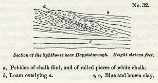
No. 32: Section at the lighthouse near Happisborough. Height sixteen feet.
a, Pebbles of chalk flint, and of rolled pieces of white chalk.
b, Loam overlying a.
c, c, Blue and brown clay.
This diagonal arrangement of the layers, sometimes called 'false stratification,' is not confined to deposits of fine sand and comminuted shells, for we find beds of shingle disposed in the same manner as is seen in the annexed section (No. 32).
The direction of the dip of the inclined layers, throughout the Suffolk coast, is so uniformly to the south, that I only saw two or three instances of a contrary nature, where the inclination was northerly. One of the best examples of this variation is exhibited in a cliff between Mismer and Dunwich, wood-cut No. 33. In this case, there are about six layers in the thickness of an inch, and the part of the cliff represented is about six feet high.
No. 33: Section of part of Little Cat cliff, composed of quartzose sand, showing the inclination of the layers in opposite directions.
Another example may be seen near Walton, where the layers, which are of extreme tenuity, consist of ferruginous sand, brown loam, and comminuted shells. It is not uncommon to find in this manner sets of perfectly horizontal strata resting upon and covered by groups of wavy and transverse layers.
No. 34: Lamination Of shelly sand and loam. near the Signal-house, Walton. Vertical height four feet.
The appearances exhibited in the diagrams are not peculiar to the crag, and I have seen sand and pebble-beds of all ages, including the old red sandstone, greywacke, and clay-slate, exhibit the same arrangement.
When we inquire into the causes of such a disposition of the materials of each bed or group of layers, we may, in the first place, remark, that however numerous may be the successive layers a, b, c, the layer a must have been deposited before b, b before c, and so of the rest.
No. 35.
We must suppose that each thin seam was thrown down on a slope, and that it conformed itself to the side of the steep bank, just as we see the materials of a talus arrange themselves at the foot of a cliff when they have been cast down successively from above. If the transverse layers are cut off by a nearly horizontal line, as in many of the above sections, it may arise from the denuding action of a wave which has carried away the upper portion of a submarine bank and truncated the layers of which it was composed. But I do not conceive this hypothesis to be necessary; for if a bank have a steep side, it may grow by the successive apposition of thin strata thrown down upon its slanting side, and the removal of matter from the top may proceed simultaneously with its lateral extension. The same current may borrow from the top what it gives to the sides, a mode of formation which I had lately an opportunity of observing on the rippled surface of the hills of blown sand near Calais. The undulating ridges and intervening furrows on the dunes of blown sand resembled exactly in form those caused by the waves on a sea-beach, and were always at right angles to the direction of the wind which had produced them. Each ridge had one side slightly inclined and the other steep, the lee side being always steep, as b c, d e, the windward side a gentle slope, as a b, c, d. When a gust of wind blew with sufficient force to drive along a cloud of sand, all the ridges were seen to be in motion at once, each encroaching on the furrow before it, and, in the course of a few minutes, filling the place which the furrows had occupied. Many grains of sand were drifted along the slopes a b, and c d, which, when they fell over the scarps b c, and d e, were under shelter from the wind, so that they remained stationary, resting, according to their shape and momentum, on different parts of the descent. In this manner each ridge was distinctly seen to move slowly on as often as the force of the wind augmented. We think that we shall not strain analogy too far if we suppose the same laws to govern the subaqueous and subaerial phenomena; and if so, we may imagine a submarine bank to be nothing more than one of the ridges of ripple on a larger scale, which may increase in the manner before suggested, by successive additions to the steep scarps.

No. 36.
The set of tides and currents, in opposite directions, may account for sudden variations in the direction of the dip of the layers, as represented in the wood-cut, No. 33, while the general prevalence of a southerly inclination in the Crag of Suffolk may indicate that the matter was brought by a current from the north.
We may refer to a drawing given in the first volume, [6] to show the analogy of the arrangement of the submarine strata, just considered, to that exhibited by deposits formed in the channels of rivers where a considerable transportation of sediment is in progress.
Derangement in the Crag strata. -- In the above examples we have explained the want of parallelism or horizontality in the subordinate layers of different strata, by reference to the mode of their original deposition; but there are signs of disturbance which can only be accounted for by subsequent movements. The same blue and brown clay, or loam, which is often perfectly horizontal, and as regularly bedded as any of our older formations, is, in other places, curved and even folded back upon itself, in the manner represented in the annexed diagrams.
No. 37: Bent strata of loam in the cliffs between Cromer and Runton.

No. 38: Folding of the strata between East and West Runton.
In the last of these cuts a central nucleus of sand is surrounded by argillaceous and sandy layers. This phenomenon is very frequent, and there are instances where the materials thus enveloped consist of broken flints mingled with pieces of chalk, forming a white mass encircled by dark laminated clay. The diameter of these included masses, as seen in sections laid open in the sea-cliffs, varies from five to fifteen feet.
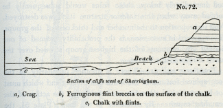
East of Sherringham, a heap of partially-rounded flints, about five feet in diameter, is nearly enveloped by finely-laminated strata of sand and loam, and some of the loam is entangled in the midst of the flints.
No. 39: Section in the Cliffs east of Sherringham.
a, Sand and loam in thin layers.
In this and similar instances, we may imagine the yielding strata, a, to have subsided into a cavity, and the flints belonging to a superincumbent bed. to have pressed down with their weight, so as to cause the strata to fold round them.
That some masses of stratified sand and loam have actually sunk down into cavities, or have fallen like landslips into ravines, seems indicated by other appearances. Thus, near Sherringham, the argillaceous beds, a, represented in the annexed diagram (No. 40), are cut off abruptly, and succeeded by the vertical and contorted series, b, c. The face of the cliff here represented, is 24 feet in height. Some of the layers in b, b, are composed of pebbles, and these alternate with thin beds of loose sand. The whole set must once have been horizontal, and must have moved in a mass, or the relative position of the several parts would not have been preserved. Similar appearances may, perhaps, be produced when chasms open during earthquakes and portions of yielding strata fall in from above and are engulphed.
No. 40: Section east of Sherringham, Norfolk.
a, Sand, loam, and blue clay.
b, b, Sand and gravel.
c, Twisted beds of loam.
Protruded masses of chalk. -- But whatever opinion we may entertain on this point, we cannot doubt that subterranean movements have given rise to some of the local derangements in this formation, particularly where masses of solid chalk pierce, as it were, the crag. Thus, between Mundesley and Trimmingham we see the appearances exhibited in the accompanying view (No. 41). The chalk, of which the strata are highly inclined, or vertical, projects in a promontory, because it offers more resistance to the action of the waves than the tertiary beds which, on both sides, constitute the whole of the cliff. The height of the soft crag strata immediately above the chalk is, in this place, about 130 feet. Those which are in contact (see the wood-cut) are inclined at an angle of 45:), and appear more disturbed than in other parts of the cliffs, as if they had been displaced by the movement by which the chalk was protruded.
No. 41: Side view of a promontory of chalk and crag, Trimmingham, Norfolk.,
a, Gravel and ferruginous sand, rounded and angular pieces of chalk flint, with some quartz pebbles, 3 feet.
b, Laminated blue clay, 8 feet.
c, Yellow sand, 1 foot 6 inches.
d, Dark blue clay with fragments of marine shells, 6 feet.
e, Yellow loam and flint gravel, 3 feet.
f, Light blue clay, 1 foot.
g, Sand and loam, 12 feet.
h, Yellow and white sand, loam, and gravel, about 100 feet.
Very similar appearances are exhibited by the northernmost of the three protuberances of chalk, of which a front view is given in the annexed diagram. It occupies a space of about 100 yards along the shore, and projects about 60 yards in advance of the general line of cliff. One of its edges, at c, rests upon the blue clay beds of the crag, in such a manner as to imply that the mass had been undermined when the crag was deposited, unless we suppose, as some have done, that this chalk is a great detached mass enveloped by crag. For, as one of the 'Needles', or insulated rocks of chalk, which projected 120 feet above high water-mark, at the western extremity of the Isle of Wight, fell into the sea in 1772, [7] so a pinnacle of chalk may have been precipitated into the tertiary sea, at a point where some strata of the crag had previously accumulated. The beds of flint and chalk in the above diagram appear nearly horizontal, but they are in fact highly inclined inwards towards the cliff. The rapid waste of the Norfolk coast might soon enable us to understand the true position of this mass, if observations and drawings are made from time to time of the appearances which present themselves.
No. 42: Northern protuberance of chalk, Trimmingham.
a. Chalk with flints.
b. Gravel, of broken and half-rounded flints.
c. Laminated blue clay.
d. Sand and yellow loam.
Perhaps it may be necessary to suppose, that subterranean movements were in progress during the deposition of the crag, and the extraordinary dislocations of the beds, in some places, which in others are perfectly regular and horizontal, may be most easily accounted for by introducing an alternate rise and depression of the bed of the sea, such as we know to be usually attendant on a series of subterranean convulsions. Several of the contortions may also have been produced by lateral movements.
Passage of marine crag into alluvium. -- By supposing the adjoining lands to have participated in this movement, we may explain the origin of those masses of an alluvial character which contain the detritus of many rocks, the bones of land animals and of drift timber, which were evidently swept down into the sea. The land-floods which accompany earthquakes are, as we have seen, capable of transporting such materials to great distances, [8] and, as part of these alluviums must be left somewhere upon the land, we may expect to find, on exploring the interior, a gradual passage from the terrestrial alluvium to that which was carried down into the sea, and which alternates with marine beds.
The fossil quadrupeds imbedded in the crag appear to be the same as those of a great part of the alluviums of the interior of England, which may, therefore, have been formed when the testacea of the older Pliocene period were in existence.
Upon the whole, we may imagine the crag strata to bear a great resemblance to the formations which may now be in progress in the sea between the British and Dutch coasts, -- a sea for the most part shallow, yet having here and there a depth of 50 or 60 fathoms, and where strong tides and currents prevail; where shells, also, and zoophytes abound, and where matter drifted from wasting cliffs must be thrown down in certain receptacles in the form of sand, shingle, and mud.
In conclusion we may observe that the history of the crag requires further elucidation, and the author is by no means satisfied with the sketch above given; but as the country is so accessible and the formation so interesting both in its structure and zoological characters, it is hoped that these remarks may excite curiosity and lead to fuller investigation.
Sheppey. -- Ramsgate. -- Brighton. -- Deposits have lately been observed by Mr. Crow [9] resting on the London clay, in the Isle of Sheppey, at the height of 140 feet above the sea, and by Captain Kater at Pegwell Bay, near Ramsgate, at the height of a few yards, and by Mr. Mantell, in the cliffs near Brighton, all containing recent marine shells. But as there are only five or six species yet discovered in these localities, we cannot decide, till we obtain further information, whether these strata belong to the crag or to a more recent formation.
_______________
Notes:
1. Chap. ii. p. 19.
2. See above, Diagram No.4, p. 21.
3. Page 54.
4. R. Taylor, Geol. of East Norfolk.
5. This section is compiled principally from one by Mr. Murchison, the others in this chapter are from drawings by the Author.
6. Chap. xiv., Diag. No. 6.
7. Dodsley's Annual Register, vol. xv. p. 140.
8. Vol. i. chap. 25.
9. Of Christ Church College, Cambridge.
Crag of Norfolk and Suffolk – Shown by its fossil contents to belong to the older Pliocene period – Heterogeneous in its composition – Superincumbent lacustrine deposits – Relative position of the crag – Forms of stratification – Strata composed of groups of oblique layers – Cause of this arrangement – Dislocations in the crag produced by subterranean movements – Protruded masses of chalk – Passage of marine crag into alluvium – Recent shells in a deposit at Sheppey, Ramsgate, and Brighton
CRAG OF NORFOLK AND SUFFOLK.
THE older Pliocene strata, described in the last chapter, are all situated in countries bordering the Mediterranean, but we shall now consider a group in our own island, which belongs to the same era. We have already alluded to this deposit under the provincial name of crag, [1] and pointed out its superposition to the London clay, a tertiary formation of much higher antiquity. [2] The crag is chiefly developed in the eastern parts of Norfolk and Suffolk, from whence it extends into Essex.
Its relative age. -- A collection of the shells of the 'crag' beds, which I formed in 1829, together with a much larger number sent me by my friend, Mr. Mantell of Lewes, were carefully examined by M. Deshayes, and compared to the tertiary species in his cabinet. This comparison gave the following result: out of 111 species, 66 were extinct or unknown, and 45 recent, the last, with one exception (Voluta Lamberti, Sow.), being now inhabitants of the German ocean. Such being the proportion of recent and extinct species, we may conclude, according to the rules before laid down, [3] that the crag belongs to the older Pliocene period.
Mineral composition. -- So heterogeneous is this deposit in mineral character, that we can scarcely convey any correct notions of its appearance, without describing the beds separately in the different localities where they occur. In general, they consist of sand, gravel, and blue or brown marl-the shells imbedded in the sand and marl being, for the most part, broken and sometimes finely comminuted. In a few spots we find the deposit in the form of a soft stratified rock, composed almost entirely of corals, sponges, and echini, [4] an assemblage of species which probably lived in a tranquil sea of some depth. In other parts of our coast it consists of alternations of sand and shingle, destitute of organic remains, and more than 200 feet in thickness, as in the Suffolk cliffs, between Dunwich and Yarmouth. In others, we meet with an enormous mass, more than 300 feet in thickness, of sand, loam, and clay, containing bones of terrestrial quadrupeds and drift wood, sometimes stratified regularly, at others consisting of a confused heap of rubbish, in which fragments of the chalk and its flints are imbedded in a chalky marl.
In this aggregate are also found many fragments of older rocks, the septaria of the London clay, together with ammonites, vertebrae of ichthyosauri, and other fossils from parts of the oolitic series. It has been questioned whether all the above-mentioned beds can be considered as belonging to the same era. The subject may admit of doubt, but after examining, in 1829, the whole line of coast of Essex, Suffolk, and Norfolk, I found it impossible to draw any line of separation between the different groups. Each seemed in its turn to pass into another, and those masses which approach in character to alluvium, and contain the remains of terrestrial quadrupeds, are occasionally intermixed with the strata of the crag.
There are, however, lacustrine deposits overlying the crag, which probably belong to a distinct zoological period. These are found in small cavities, which must have existed on the surface of the crag after its elevation, and which formed small lakes or ponds wherein recent fresh-water testacea were included in loamy strata. (See wood-cut, No. 30, c.)
Relative position. -- The crag is seen to rest on the chalk and on the London clay, but usually on the former. The strata are in great part horizontal, or slightly undulating; but at some points they are much disturbed, especially where several masses of chalk appear to have been protruded from below.
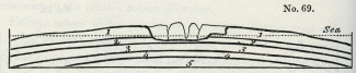
The annexed section may give a general idea of the manner in which the crag may be supposed to rest on the chalk as we pass from the Norfolk cliffs, at Trimmingham, into the interior, where the country rises gradually.
No. 30.
a, Chalk.
b, Crag.
c, Lacustrine deposit.
D, Trimmingham beacon.
E, Interior and higher parts of Norfolk. [5]
The outline of the surface of the subjacent chalk, in this section, is imaginary, but is such as might explain the relations of those protruded masses, three of which appear in the cliffs near Trimmingham, and which some geologists have too hastily assumed to be unconnected with the great mass of chalk below. We shall treat of these presently, when we describe the disturbances which the crag appears to have suffered since its original deposition.
In the interior, at E, there is a thick covering of sand and gravel upon the chalk, having the characters of an alluvium, partly, perhaps, marine, and partly terrestrial, and which seems to pass gradually in this district into the regular marine strata of the crag.
Forms of stratification. -- In almost every formation the individual strata are rarely persistent for a great distance, the superior and inferior planes being seldom precisely parallel to each other; and if the materials are very coarse, the beds often thin out if we trace them for a few hundred yards. There are also many cases where all the layers are oblique to the general direction of the strata, and the crag affords most interesting illustrations of this phenomenon.
In the sea-cliff near Walton, in Suffolk, opposite the Martello Tower, called R, the section represented in the annexed diagram is seen. The vertical height is about 20 feet, and the beds consist alternately of sets of inclined and horizontal layers of sand and comminuted shells. The sand is siliceous and of a ferruginous colour, but the layers are sometimes made up of small plates of bivalve shells, arranged with their flat sides parallel to the plane of each layer, like mica in micaceous sandstones.
No. 31: Section of shelly crag near Walton, Suffolk.
The number of laminae in the thickness of an inch, both in the siliceous and shelly sand, varies from seven to ten in number, so that it is impossible to express them all ill the diagram. The height of the uppermost stratum is, in this instance, remarkable, as it extends to twelve feet. The inclination of the laminae is about 30°; but in the cliffs of Bawdesey, to the eastward, they are sometimes inclined at an angle of 45°, and even more.
No. 32: Section at the lighthouse near Happisborough. Height sixteen feet.
a, Pebbles of chalk flint, and of rolled pieces of white chalk.
b, Loam overlying a.
c, c, Blue and brown clay.
This diagonal arrangement of the layers, sometimes called 'false stratification,' is not confined to deposits of fine sand and comminuted shells, for we find beds of shingle disposed in the same manner as is seen in the annexed section (No. 32).
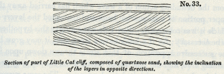
The direction of the dip of the inclined layers, throughout the Suffolk coast, is so uniformly to the south, that I only saw two or three instances of a contrary nature, where the inclination was northerly. One of the best examples of this variation is exhibited in a cliff between Mismer and Dunwich, wood-cut No. 33. In this case, there are about six layers in the thickness of an inch, and the part of the cliff represented is about six feet high.
No. 33: Section of part of Little Cat cliff, composed of quartzose sand, showing the inclination of the layers in opposite directions.
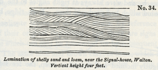
Another example may be seen near Walton, where the layers, which are of extreme tenuity, consist of ferruginous sand, brown loam, and comminuted shells. It is not uncommon to find in this manner sets of perfectly horizontal strata resting upon and covered by groups of wavy and transverse layers.
No. 34: Lamination Of shelly sand and loam. near the Signal-house, Walton. Vertical height four feet.
The appearances exhibited in the diagrams are not peculiar to the crag, and I have seen sand and pebble-beds of all ages, including the old red sandstone, greywacke, and clay-slate, exhibit the same arrangement.
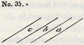
When we inquire into the causes of such a disposition of the materials of each bed or group of layers, we may, in the first place, remark, that however numerous may be the successive layers a, b, c, the layer a must have been deposited before b, b before c, and so of the rest.
No. 35.
We must suppose that each thin seam was thrown down on a slope, and that it conformed itself to the side of the steep bank, just as we see the materials of a talus arrange themselves at the foot of a cliff when they have been cast down successively from above. If the transverse layers are cut off by a nearly horizontal line, as in many of the above sections, it may arise from the denuding action of a wave which has carried away the upper portion of a submarine bank and truncated the layers of which it was composed. But I do not conceive this hypothesis to be necessary; for if a bank have a steep side, it may grow by the successive apposition of thin strata thrown down upon its slanting side, and the removal of matter from the top may proceed simultaneously with its lateral extension. The same current may borrow from the top what it gives to the sides, a mode of formation which I had lately an opportunity of observing on the rippled surface of the hills of blown sand near Calais. The undulating ridges and intervening furrows on the dunes of blown sand resembled exactly in form those caused by the waves on a sea-beach, and were always at right angles to the direction of the wind which had produced them. Each ridge had one side slightly inclined and the other steep, the lee side being always steep, as b c, d e, the windward side a gentle slope, as a b, c, d. When a gust of wind blew with sufficient force to drive along a cloud of sand, all the ridges were seen to be in motion at once, each encroaching on the furrow before it, and, in the course of a few minutes, filling the place which the furrows had occupied. Many grains of sand were drifted along the slopes a b, and c d, which, when they fell over the scarps b c, and d e, were under shelter from the wind, so that they remained stationary, resting, according to their shape and momentum, on different parts of the descent. In this manner each ridge was distinctly seen to move slowly on as often as the force of the wind augmented. We think that we shall not strain analogy too far if we suppose the same laws to govern the subaqueous and subaerial phenomena; and if so, we may imagine a submarine bank to be nothing more than one of the ridges of ripple on a larger scale, which may increase in the manner before suggested, by successive additions to the steep scarps.
No. 36.
The set of tides and currents, in opposite directions, may account for sudden variations in the direction of the dip of the layers, as represented in the wood-cut, No. 33, while the general prevalence of a southerly inclination in the Crag of Suffolk may indicate that the matter was brought by a current from the north.
We may refer to a drawing given in the first volume, [6] to show the analogy of the arrangement of the submarine strata, just considered, to that exhibited by deposits formed in the channels of rivers where a considerable transportation of sediment is in progress.
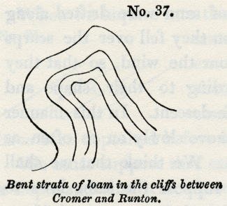
Derangement in the Crag strata. -- In the above examples we have explained the want of parallelism or horizontality in the subordinate layers of different strata, by reference to the mode of their original deposition; but there are signs of disturbance which can only be accounted for by subsequent movements. The same blue and brown clay, or loam, which is often perfectly horizontal, and as regularly bedded as any of our older formations, is, in other places, curved and even folded back upon itself, in the manner represented in the annexed diagrams.
No. 37: Bent strata of loam in the cliffs between Cromer and Runton.
No. 38: Folding of the strata between East and West Runton.
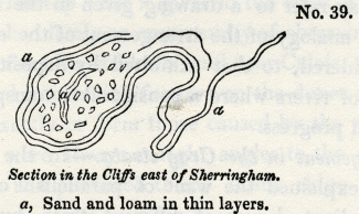
In the last of these cuts a central nucleus of sand is surrounded by argillaceous and sandy layers. This phenomenon is very frequent, and there are instances where the materials thus enveloped consist of broken flints mingled with pieces of chalk, forming a white mass encircled by dark laminated clay. The diameter of these included masses, as seen in sections laid open in the sea-cliffs, varies from five to fifteen feet.
East of Sherringham, a heap of partially-rounded flints, about five feet in diameter, is nearly enveloped by finely-laminated strata of sand and loam, and some of the loam is entangled in the midst of the flints.
No. 39: Section in the Cliffs east of Sherringham.
a, Sand and loam in thin layers.
In this and similar instances, we may imagine the yielding strata, a, to have subsided into a cavity, and the flints belonging to a superincumbent bed. to have pressed down with their weight, so as to cause the strata to fold round them.
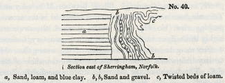
That some masses of stratified sand and loam have actually sunk down into cavities, or have fallen like landslips into ravines, seems indicated by other appearances. Thus, near Sherringham, the argillaceous beds, a, represented in the annexed diagram (No. 40), are cut off abruptly, and succeeded by the vertical and contorted series, b, c. The face of the cliff here represented, is 24 feet in height. Some of the layers in b, b, are composed of pebbles, and these alternate with thin beds of loose sand. The whole set must once have been horizontal, and must have moved in a mass, or the relative position of the several parts would not have been preserved. Similar appearances may, perhaps, be produced when chasms open during earthquakes and portions of yielding strata fall in from above and are engulphed.
No. 40: Section east of Sherringham, Norfolk.
a, Sand, loam, and blue clay.
b, b, Sand and gravel.
c, Twisted beds of loam.
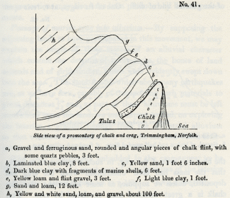
Protruded masses of chalk. -- But whatever opinion we may entertain on this point, we cannot doubt that subterranean movements have given rise to some of the local derangements in this formation, particularly where masses of solid chalk pierce, as it were, the crag. Thus, between Mundesley and Trimmingham we see the appearances exhibited in the accompanying view (No. 41). The chalk, of which the strata are highly inclined, or vertical, projects in a promontory, because it offers more resistance to the action of the waves than the tertiary beds which, on both sides, constitute the whole of the cliff. The height of the soft crag strata immediately above the chalk is, in this place, about 130 feet. Those which are in contact (see the wood-cut) are inclined at an angle of 45:), and appear more disturbed than in other parts of the cliffs, as if they had been displaced by the movement by which the chalk was protruded.
No. 41: Side view of a promontory of chalk and crag, Trimmingham, Norfolk.,
a, Gravel and ferruginous sand, rounded and angular pieces of chalk flint, with some quartz pebbles, 3 feet.
b, Laminated blue clay, 8 feet.
c, Yellow sand, 1 foot 6 inches.
d, Dark blue clay with fragments of marine shells, 6 feet.
e, Yellow loam and flint gravel, 3 feet.
f, Light blue clay, 1 foot.
g, Sand and loam, 12 feet.
h, Yellow and white sand, loam, and gravel, about 100 feet.
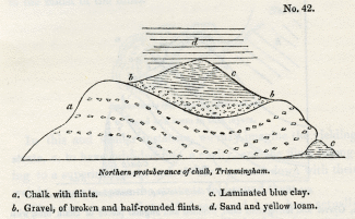
Very similar appearances are exhibited by the northernmost of the three protuberances of chalk, of which a front view is given in the annexed diagram. It occupies a space of about 100 yards along the shore, and projects about 60 yards in advance of the general line of cliff. One of its edges, at c, rests upon the blue clay beds of the crag, in such a manner as to imply that the mass had been undermined when the crag was deposited, unless we suppose, as some have done, that this chalk is a great detached mass enveloped by crag. For, as one of the 'Needles', or insulated rocks of chalk, which projected 120 feet above high water-mark, at the western extremity of the Isle of Wight, fell into the sea in 1772, [7] so a pinnacle of chalk may have been precipitated into the tertiary sea, at a point where some strata of the crag had previously accumulated. The beds of flint and chalk in the above diagram appear nearly horizontal, but they are in fact highly inclined inwards towards the cliff. The rapid waste of the Norfolk coast might soon enable us to understand the true position of this mass, if observations and drawings are made from time to time of the appearances which present themselves.
No. 42: Northern protuberance of chalk, Trimmingham.
a. Chalk with flints.
b. Gravel, of broken and half-rounded flints.
c. Laminated blue clay.
d. Sand and yellow loam.
Perhaps it may be necessary to suppose, that subterranean movements were in progress during the deposition of the crag, and the extraordinary dislocations of the beds, in some places, which in others are perfectly regular and horizontal, may be most easily accounted for by introducing an alternate rise and depression of the bed of the sea, such as we know to be usually attendant on a series of subterranean convulsions. Several of the contortions may also have been produced by lateral movements.
Passage of marine crag into alluvium. -- By supposing the adjoining lands to have participated in this movement, we may explain the origin of those masses of an alluvial character which contain the detritus of many rocks, the bones of land animals and of drift timber, which were evidently swept down into the sea. The land-floods which accompany earthquakes are, as we have seen, capable of transporting such materials to great distances, [8] and, as part of these alluviums must be left somewhere upon the land, we may expect to find, on exploring the interior, a gradual passage from the terrestrial alluvium to that which was carried down into the sea, and which alternates with marine beds.
The fossil quadrupeds imbedded in the crag appear to be the same as those of a great part of the alluviums of the interior of England, which may, therefore, have been formed when the testacea of the older Pliocene period were in existence.
Upon the whole, we may imagine the crag strata to bear a great resemblance to the formations which may now be in progress in the sea between the British and Dutch coasts, -- a sea for the most part shallow, yet having here and there a depth of 50 or 60 fathoms, and where strong tides and currents prevail; where shells, also, and zoophytes abound, and where matter drifted from wasting cliffs must be thrown down in certain receptacles in the form of sand, shingle, and mud.
In conclusion we may observe that the history of the crag requires further elucidation, and the author is by no means satisfied with the sketch above given; but as the country is so accessible and the formation so interesting both in its structure and zoological characters, it is hoped that these remarks may excite curiosity and lead to fuller investigation.
Sheppey. -- Ramsgate. -- Brighton. -- Deposits have lately been observed by Mr. Crow [9] resting on the London clay, in the Isle of Sheppey, at the height of 140 feet above the sea, and by Captain Kater at Pegwell Bay, near Ramsgate, at the height of a few yards, and by Mr. Mantell, in the cliffs near Brighton, all containing recent marine shells. But as there are only five or six species yet discovered in these localities, we cannot decide, till we obtain further information, whether these strata belong to the crag or to a more recent formation.
_______________
Notes:
1. Chap. ii. p. 19.
2. See above, Diagram No.4, p. 21.
3. Page 54.
4. R. Taylor, Geol. of East Norfolk.
5. This section is compiled principally from one by Mr. Murchison, the others in this chapter are from drawings by the Author.
6. Chap. xiv., Diag. No. 6.
7. Dodsley's Annual Register, vol. xv. p. 140.
8. Vol. i. chap. 25.
9. Of Christ Church College, Cambridge.